Glossary

Sort by

A

Aphelion 

Aphelion is the point in the orbit of a planet, asteroid, or.. more

A

Apophysis 

An apophysis is a small, offshoot intrusion of igneous rock that extends.. more

A

Aquiclude 

An aquiclude is a geological formation that, although porous, is impermeable to.. more

A

Aquifer 

An aquifer is a geological formation that can store, transmit, and yield.. more

A

Aquitard 

An aquitard is a geological formation that has low permeability and transmits.. more

A

Archipelago 

An archipelago is a chain or cluster of islands that are formed.. more

A

Arête 

An arête is a sharp, narrow ridge formed between two glacial valleys.. more

A

Aridisol 

Aridisols are a soil order found in arid and semi-arid regions, characterized.. more

A

Arroyo 

An arroyo is a dry creek or stream bed that temporarily or.. more

A

Asthenosphere 

The asthenosphere is a semi-fluid layer within the Earth's mantle, situated beneath.. more

A

Asymmetrical Fold 

An asymmetrical fold is a geological fold in which the limbs of.. more

A

Avalanche 

An avalanche is a rapid flow of snow, ice, and debris down.. more

A

Axial Plane 

The axial plane is an imaginary plane that divides a fold symmetrically.. more

A

Axial Rift 

An axial rift is a linear, narrow trough or valley formed at.. more

A

Axial Tilt 

Axial tilt, also known as obliquity, is the angle between a planet's.. more

B

Back-Arc Basin 

A back-arc basin is a submarine feature associated with subduction zones, formed.. more

B

Bajada 

A bajada is a broad, gently sloping depositional surface formed by the.. more

B

Ball-and-Pillow Structure 

Ball-and-pillow structures are soft-sediment deformation features that form when denser, water-saturated sediment.. more

B

Bar Built Estuary 

A bar-built estuary is an estuary that is formed behind a barrier.. more

B

Barchan Dune 

Barchan dunes are crescent-shaped sand dunes with a convex side facing the.. more

B

Barrier Island 

Barrier islands are long, narrow, offshore landforms made of sand and sediment.. more

B

Basal Sliding 

Basal sliding refers to the movement of a glacier over its bed,.. more

B

Basaltic Lava Flow 

Basaltic lava flows are formed from the eruption of basalt, a type.. more
Load More

Olivine

Fact Sheet:
– Chemical Composition: (Mg, Fe)₂SiO₄ (Magnesium Iron Silicate)
– Hardness: 6.5 to 7 on the Mohs scale
– Crystal System: Orthorhombic
– Color Varieties: Green, yellow-green, brown
– Major Localities: United States, Norway, Myanmar, and Pakistan
– Common Uses: Gemstone (peridot), refractory material, industrial sand, and in high-temperature furnaces

Introduction: Olivine, known for its beautiful green hue, is a common silicate mineral that forms deep within the Earth’s mantle. It is best known as the gemstone peridot and has significant geological importance due to its presence in mantle rocks and its role in tectonic processes.

Formation: Olivine primarily ...

Read more

AAphelion 

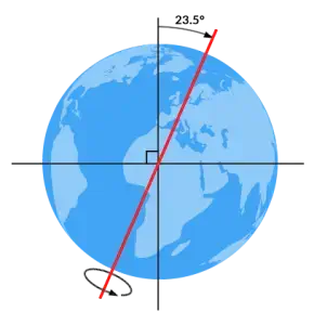
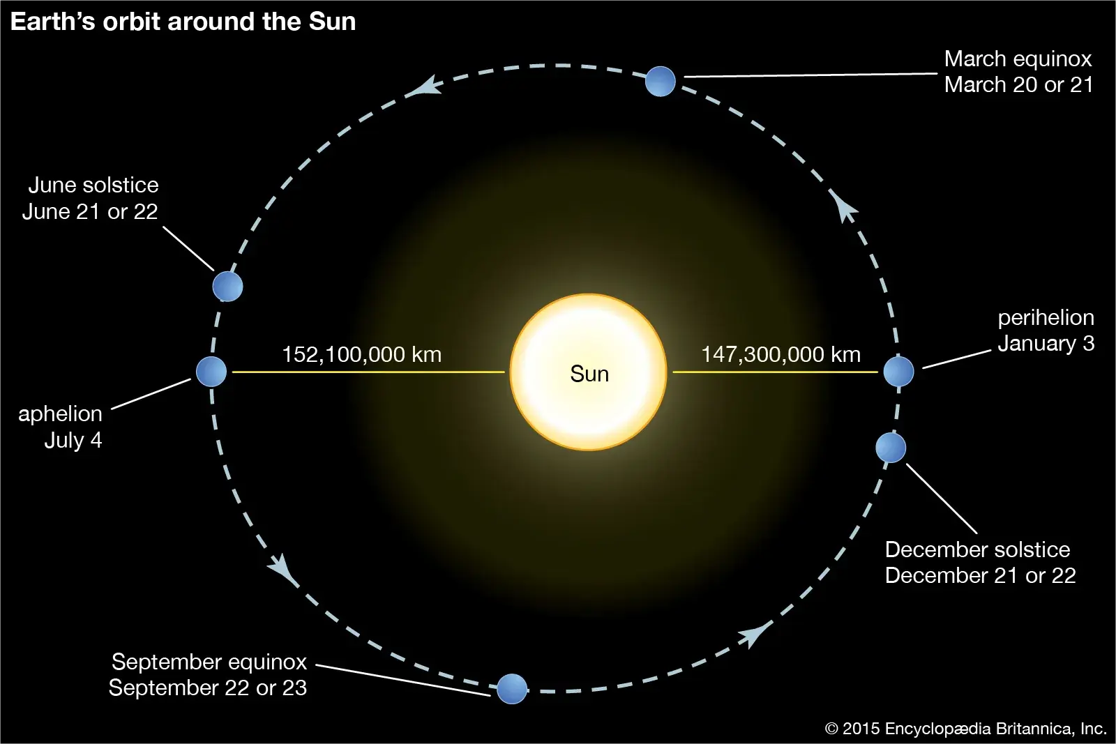
Aphelion is the point in the orbit of a planet, asteroid, or comet where it is farthest from the Sun. For Earth, this occurs in early July. The concept of aphelion is important in understanding the variations in solar energy received by a planet, which can influence seasonal climate patterns. The difference in distance between aphelion and perihelion (the closest point) contributes to the Earth’s elliptical orbit. 

Reference: Laskar, J., Robutel, P., Joutel, F., Gastineau, M., Correia, A. C. M., & Levrard, B. (2004). “A Long-Term Numerical Solution for the Insolation Quantities of the Earth.” Astronomy & Astrophysics, 428(1), 261-285. 

Share 

AApophysis 

An apophysis is a small, offshoot intrusion of igneous rock that extends from a larger igneous body, such as a batholith or pluton. Apophyses are significant in studying the intrusion and cooling processes of igneous rocks, as well as in understanding the complex geometry of magmatic systems. 

Reference: Best, M. G. (2003). Igneous and Metamorphic Petrology. Wiley-Blackwell. 

Share 

AAquiclude 

An aquiclude is a geological formation that, although porous, is impermeable to water, effectively acting as a barrier to groundwater flow. Aquicludes are composed of materials like clay or shale that prevent the movement of water between aquifers. Understanding aquicludes is important in hydrogeology for managing groundwater resources and predicting the movement of contaminants. 

Reference: Todd, D. K., & Mays, L. W. (2005). Groundwater Hydrology. John Wiley & Sons. 

Share 

AAquifer 

An aquifer is a geological formation that can store, transmit, and yield water to wells or springs. Aquifers are composed of permeable materials such as sand, gravel, or fractured rock. They can be confined, with impermeable layers above and below, or unconfined, where they are directly recharged by surface water. Aquifers are crucial for water supply in many regions and are a primary focus in the study of hydrogeology. 

Reference: Freeze, R. A., & Cherry, J. A. (1979). Groundwater. Prentice-Hall. 

Share 

AAquitard 

An aquitard is a geological formation that has low permeability and transmits water at a much slower rate than an aquifer. While not completely impermeable, aquitards significantly impede the flow of groundwater, often acting as a confining layer between two aquifers. Understanding aquitards is essential in hydrogeology for groundwater modeling and resource management. 

Reference: Fetter, C. W. (2001). Applied Hydrogeology. Prentice-Hall. 

Share 

AArchipelago 

An archipelago is a chain or cluster of islands that are formed by tectonic, volcanic, or erosional processes. Archipelagos can result from volcanic activity, as in the case of the Hawaiian Islands, or from the flooding of landmasses due to sea-level rise. These island groups are important for studying biogeography, evolution, and the impact of isolation on species development. 

Reference: Gillespie, R. G., & Clague, D. A. (2009). Encyclopedia of Islands. University of California Press. 

Share 

AArête 

An arête is a sharp, narrow ridge formed between two glacial valleys or cirques. It is typically created by the erosion of glaciers that carve out the sides of a mountain, leaving a steep, knife-edge ridge. Arêtes are common in alpine regions and are significant in understanding the processes of glacial erosion and mountain geomorphology. 

Reference: Benn, D. I., & Evans, D. J. A. (2010). Glaciers and Glaciation. Routledge. 

Share 

AAridisol 

Aridisols are a soil order found in arid and semi-arid regions, characterized by a lack of organic matter and the presence of calcium carbonate or gypsum horizons. These soils are important in the study of desert ecosystems and land use, particularly in understanding soil fertility and the challenges of agriculture in dry climates. 

Reference: Soil Survey Staff (1999). Soil Taxonomy: A Basic System of Soil Classification for Making and Interpreting Soil Surveys. USDA Natural Resources Conservation Service. 

Share 

AArroyo 

An arroyo is a dry creek or stream bed that temporarily or seasonally fills with water after heavy rainfalls, commonly found in arid and semi-arid regions. Arroyos can be sites of flash flooding, and their presence is indicative of episodic water flow and erosion in dryland environments. They are significant in the study of desert hydrology and sediment transport. 

Reference: Bull, W. B. (1997). “Discontinuous Ephemeral Streams.” Geomorphology, 19(3-4), 227-276. 

Share 

AAsthenosphere 

The asthenosphere is a semi-fluid layer within the Earth’s mantle, situated beneath the lithosphere. It extends from about 100 to 700 kilometers below the Earth’s surface and is composed of partially molten rock that allows tectonic plates to move. The asthenosphere plays a crucial role in plate tectonics and is involved in the convection currents that drive the movement of the Earth’s lithospheric plates. 

Reference: Turcotte, D. L., & Schubert, G. (2014). Geodynamics. Cambridge University Press. 

Share 

AAsymmetrical Fold 

An asymmetrical fold is a geological fold in which the limbs of the fold are not mirror images of each other. One limb is steeper than the other, and the fold axis may be inclined rather than horizontal. Asymmetrical folds are important indicators of the direction and magnitude of the forces that caused the folding, providing insights into tectonic stress and deformation history. 

Reference: Davis, G. H., & Reynolds, S. J. (1996). Structural Geology of Rocks and Regions. John Wiley & Sons.

Share 

AAvalanche 

An avalanche is a rapid flow of snow, ice, and debris down a mountainside, often triggered by a combination of factors including snow accumulation, temperature changes, and gravitational forces. Avalanches can be highly destructive, and their occurrence is influenced by the snowpack structure, slope angle, and weather conditions. They are studied extensively in the fields of geology and environmental science for risk assessment and mitigation in mountainous regions.

Reference: McClung, D., & Schaerer, P. (2006). The Avalanche Handbook. The Mountaineers Books. 

Share 

AAxial Plane 

The axial plane is an imaginary plane that divides a fold symmetrically into two equal halves. It is often used in structural geology to describe the orientation of folds and the relationship between different rock layers. The axial plane plays a crucial role in understanding the geometry of folded rock layers and the tectonic forces that caused the folding. 

Reference: Ramsay, J. G. (1967). Folding and Fracturing of Rocks. McGraw-Hill. 

Share 

AAxial Rift 

An axial rift is a linear, narrow trough or valley formed at a divergent plate boundary where two tectonic plates are pulling apart. These rifts are typically found along mid-ocean ridges and are the sites of active volcanism and crustal formation. The study of axial rifts is important for understanding the processes of seafloor spreading and the formation of new oceanic crust. 

Reference: Macdonald, K. C. (1982). “Mid-Ocean Ridges: Fine Scale Tectonic, Volcanic and Hydrothermal Processes within the Plate Boundary Zone.” Annual Review of Earth and Planetary Sciences, 10, 155-190. 

Share 

AAxial Tilt 

Axial tilt, also known as obliquity, is the angle between a planet’s rotational axis and its orbital axis. Earth’s axial tilt is approximately 23.5 degrees, which is responsible for the seasonal variations in climate. Changes in axial tilt over geological timescales can influence climate patterns and are a key factor in the study of Earth’s paleoclimate. 

Reference: Laskar, J., Robutel, P., Joutel, F., Gastineau, M., Correia, A. C. M., & Levrard, B. (2004). “A Long-Term Numerical Solution for the Insolation Quantities of the Earth.” Astronomy & Astrophysics, 428(1), 261-285. 

Share 

BBack-Arc Basin 

A back-arc basin is a submarine feature associated with subduction zones, formed behind a volcanic arc. These basins are created by the process of back-arc spreading, which occurs when the overriding tectonic plate is stretched due to the rollback of the subducting plate. Back-arc basins are important in understanding the dynamics of plate tectonics, particularly in how they relate to the formation of new oceanic crust and volcanic activity. 

Reference: Stern, R. J., & Scholl, D. W. (2010). “Back-Arc Basins.” In: Encyclopedia of Ocean Sciences, Elsevier. 

Share 

BBajada 

A bajada is a broad, gently sloping depositional surface formed by the coalescence of multiple alluvial fans at the base of a mountain range in arid and semi-arid regions. Bajadas are significant in understanding the sedimentary processes in desert environments and the interaction between tectonics, erosion, and sedimentation. 

Reference: Blair, T. C., & McPherson, J. G. (1994). “Alluvial Fans and Their Natural Distinction from Rivers Based on Morphology, Hydraulic Processes, Sedimentary Processes, and Facies Assemblages.” Journal of Sedimentary Research, 64(3), 450-489. 

Share 

BBall-and-Pillow Structure 

Ball-and-pillow structures are soft-sediment deformation features that form when denser, water-saturated sediment layers sink into underlying less-dense layers, creating rounded “ball” shapes. These structures are important indicators of rapid sedimentation and seismic activity and are often found in deltaic and turbidite deposits. 

Reference: Lowe, D. R. (1975). “Water Escape Structures in Coarse-Grained Sediments.” Sedimentology, 22(2), 157-204. 

Share 

BBar Built Estuary 

A bar-built estuary is an estuary that is formed behind a barrier such as a sandbar or spit, typically found along coastal plains. These estuaries are characterized by their shallow waters and limited tidal exchange with the open ocean. They are important ecosystems and are studied for their unique hydrology and role in coastal sediment dynamics. 

Reference: Day, J. W., Kemp, G. P., & Yáñez-Arancibia, A. (2012). Estuarine Ecology. Wiley-Blackwell. 

Share 

BBarchan Dune 

Barchan dunes are crescent-shaped sand dunes with a convex side facing the wind and horns pointing downwind. They form in areas where sand supply is limited, and wind direction is constant. Barchan dunes are significant in the study of desert geomorphology and aeolian processes, providing insights into wind patterns and sediment transport in arid environments. 

Reference: Lancaster, N. (1995). Geomorphology of Desert Dunes. Routledge. 

Share 

BBarrier Island 

Barrier islands are long, narrow, offshore landforms made of sand and sediment that run parallel to the coast. They act as protective barriers against storms and waves, shielding the mainland coast from erosion. Barrier islands are dynamic systems, constantly reshaped by wind, waves, and tides, and are significant in coastal ecology and geology. 

Reference: Stutz, M. L., & Pilkey, O. H. (2011). “Open-Ocean Barrier Islands: Global Influence of Climatic, Oceanographic, and Depositional Settings.” Journal of Coastal Research, 27(2), 207-222. 

Share 

BBasal Sliding 

Basal sliding refers to the movement of a glacier over its bed, facilitated by the presence of meltwater that reduces friction between the ice and the underlying rock. This process is an important component of glacier dynamics and contributes significantly to the overall movement of glaciers, especially in temperate regions where melting is more common. 

Reference: Cuffey, K. M., & Paterson, W. S. B. (2010). The Physics of Glaciers. Elsevier. 

Share 

BBasaltic Lava Flow 

Basaltic lava flows are formed from the eruption of basalt, a type of mafic igneous rock that is low in silica and has a high fluidity. These flows can spread over large areas due to their low viscosity and can form different structures such as pahoehoe (smooth, ropy surface) or ‘a’a (rough, jagged surface). Basaltic lava flows are key in understanding volcanic processes, especially in the context of shield volcanoes and mid-ocean ridges. 

Reference: Macdonald, G. A. (1953). “Pahoehoe, Aa, and Block Lava.” American Journal of Science, 251(3), 169-191. 

Share 

ZArchives: Glossary

Zosterophylls are an extinct group of early vascular plants that lived during the Silurian and Devonian periods. They are significant in paleobotany and evolutionary biology for their role in understanding the evolution of vascular plants, the transition from aquatic to terrestrial ecosystems, and the origins of modern plant lineages. 

Reference: Kenrick, P., & Crane, P. R. (1997). “The Origin and Early Diversification of Land Plants: A Cladistic Study.” Smithsonian Institution Press. 

Share