Glossary

Sort by

U

Unconsolidated Sediment

Unconsolidated sediment refers to loose, uncemented deposits of particles, such as sand,.. more

U

Undercutting

Undercutting refers to the erosion of the base of a slope or.. more

U

Underthrusting

Underthrusting occurs when one tectonic plate is forced beneath another, a process.. more

U

Underwater Landslide

An underwater landslide, also known as a submarine landslide, is the movement.. more

U

Undulating Stratification

Undulating stratification refers to sedimentary layers that exhibit gentle, wave-like undulations, often.. more

U

Uniaxial Compression Test 

A uniaxial compression test is a laboratory test used to determine the.. more

U

Uniaxial Compression Test

A uniaxial compression test is a laboratory test used to determine the.. more

U

Unroofing

Unroofing is the geological process of erosion and removal of overlying rocks,.. more

U

Uplift

Uplift refers to the vertical elevation of the Earth's surface due to.. more

U

Uplifted Terrane

An uplifted terrane is a region of the Earth's crust that has.. more

U

Upwarping

Upwarping is the broad, gentle arching or doming of the Earth's crust,.. more

U

Upwelling

Upwelling is the process by which deep, cold, nutrient-rich water rises to.. more

U

Uranium Lead Dating

Uranium-Lead (U-Pb) dating is a radiometric dating method that uses the decay.. more

U

Uranium-Thorium Dating

Uranium-Thorium (U-Th) dating is a radiometric dating technique that measures the ratio.. more

U

Uvula

Uvula in geomorphology refers to a hanging tongue of rock, typically found.. more

V

Variscan Orogeny

The Variscan Orogeny was a significant mountain-building event that occurred during the.. more

V

Varve

A varve is a pair of sedimentary layers deposited annually, consisting of.. more

V

Vesicle

A vesicle is a small cavity within volcanic rock, formed by the.. more

V

Vesicular Texture

Vesicular texture refers to the presence of numerous small cavities, or vesicles,.. more

V

Vesuvian Eruption

A Vesuvian eruption, named after Mount Vesuvius, is a type of explosive.. more

V

Vesuvianite

Vesuvianite, also known as idocrase, is a silicate mineral found in metamorphic.. more

V

Vitrification

Vitrification is the process of converting a material into glass or a.. more

V

Vitrinite

Vitrinite is a type of maceral (organic component of coal) derived from.. more
Load More
Close-up of a granite rock sample

Granite

Granite is a durable igneous rock used in construction, monuments, and countertops.

Read more
Sedimentary rock layers showing geological strata (unconsolidated sediment)

UUnconsolidated Sediment

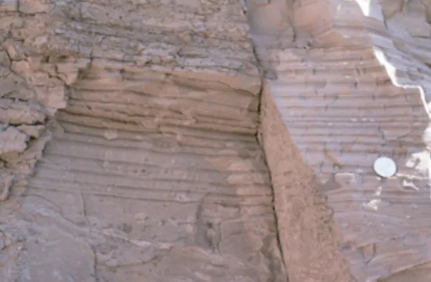
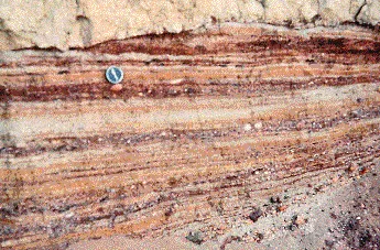
Unconsolidated sediment refers to loose, uncemented deposits of particles, such as sand, gravel, silt, and clay, that have not yet been lithified into solid rock. These sediments are significant in sedimentology for understanding depositional environments, sediment transport, and the early stages of rock formation. 

Reference: Boggs, S. (2009). “Petrology of Sedimentary Rocks.” Cambridge University Press. 

Share 

White chalk cliff by rocky beach shoreline (undercutting)

UUndercutting

Undercutting refers to the erosion of the base of a slope or cliff, typically by water, which can lead to the collapse of the overhanging rock or soil. This process is significant in geomorphology for understanding the development of landforms, the stability of slopes, and the mechanisms of mass wasting. 

Reference: Schumm, S. A. (1973). “Geomorphic Thresholds and Complex Response of Drainage Systems.” Fluvial Geomorphology, 69-85. 

Share 

Tectonic deformation processes: shortening, underthrusting, crustal flow diagram

UUnderthrusting

Underthrusting occurs when one tectonic plate is forced beneath another, a process often associated with subduction zones. This geological phenomenon is significant for understanding plate tectonics, the formation of mountain ranges, and seismic activity related to convergent plate boundaries. 

Reference: Suppe, J. (1985). “Principles of Structural Geology.” Prentice Hall.

Share 

Diagram showing submarine landslide formation process underwater (underwater landslide)

UUnderwater Landslide

An underwater landslide, also known as a submarine landslide, is the movement of a large mass of sediment or rock down the continental shelf and slope, triggered by factors such as earthquakes or rapid sedimentation. These landslides are significant in marine geology for understanding sediment transport, tsunamis, and the formation of underwater landforms. 

Reference: Hampton, M. A., Lee, H. J., & Locat, J. (1996). “Submarine Landslides.” Reviews of Geophysics, 34(1), 33-59.

Share 

UUndulating Stratification

Undulating stratification refers to sedimentary layers that exhibit gentle, wave-like undulations, often formed by the interaction of sedimentation and wave action. This stratification is significant in sedimentology for interpreting past environments, particularly shallow marine and fluvial settings. 

Reference: Reineck, H.-E., & Singh, I. B. (1980). “Depositional Sedimentary Environments.” Springer-Verlag. 

Share 

Concrete cylinder compression testing machine in laboratory (uniaxial compression test)

UUniaxial Compression Test 

A uniaxial compression test is a laboratory test used to determine the compressive strength and deformation behavior of a rock or soil sample under a single axis of compression. This test is significant in rock mechanics and engineering geology for evaluating the mechanical properties of rocks, the stability of slopes and tunnels, and the design of foundations. 

Reference: Hoek, E., & Brown, E. T. (1980). “Underground Excavations in Rock.” Institution of Mining and Metallurgy. 

Share 

UUniaxial Compression Test

A uniaxial compression test is a laboratory test used to determine the compressive strength and deformation behavior of a rock or soil sample under a single axis of compression. This test is significant in rock mechanics and engineering geology for evaluating the mechanical properties of rocks, the stability of slopes and tunnels, and the design of foundations. 

Reference: Hoek, E., & Brown, E. T. (1980). “Underground Excavations in Rock.” Institution of Mining and Metallurgy. 

Share 

UUnroofing

Unroofing is the geological process of erosion and removal of overlying rocks, exposing deeper rocks at the Earth’s surface. This process is significant in understanding the history of mountain ranges, the cooling history of rocks, and the exhumation of high-pressure metamorphic rocks. 

Reference: Brown, R. W., Summerfield, M. A., & Gleadow, A. J. W. (1994). “Apatite Fission Track Analysis of Denudation Chronologies in the British Isles.” Earth and Planetary Science Letters, 126(1-3), 1-17. 

Share 

Snow-covered Himalayan mountain range aerial view (uplift)

UUplift

Uplift refers to the vertical elevation of the Earth’s surface due to tectonic forces, such as those caused by plate collisions, volcanic activity, or the rebound following the melting of ice sheets. Uplift is significant in geology for understanding mountain building, landscape evolution, and the interaction between tectonics and erosion. 

Reference: Molnar, P., & England, P. (1990). “Late Cenozoic Uplift of Mountain Ranges and Global Climate Change: Chicken or Egg?” Nature, 346(6279), 29-34. 

Share 

Diagram of terrane accretion and volcanic arc formation (uplifted terrane)

UUplifted Terrane

An uplifted terrane is a region of the Earth’s crust that has been elevated due to tectonic forces, often resulting in the exposure of older rocks that were previously buried. This geological feature is significant in tectonics and geomorphology for understanding the processes of mountain building, crustal deformation, and the evolution of landscapes. 

Reference: Coney, P. J., Jones, D. L., & Monger, J. W. H. (1980). “Cordilleran Suspect Terranes.” Nature, 288(5789), 329-333. 

Share 

Geological models showing dome and basin formations (upwarping and downwarping)

UUpwarping

Upwarping is the broad, gentle arching or doming of the Earth’s crust, typically caused by tectonic forces or the isostatic response to the removal of overlying material. Upwarping is significant in understanding the formation of large-scale geological structures, the development of plateaus, and the processes of crustal deformation. 

Reference: Wheeler, R. L., & Cramer, C. H. (2002). “Updated Seismic Hazard in the New Madrid Seismic Zone, Central United States.” Bulletin of the Seismological Society of America, 92(2), 663-682. 

Share 

Diagram illustrating ocean upwelling near coastline (upwelling)

UUpwelling

Upwelling is the process by which deep, cold, nutrient-rich water rises to the surface, typically along coastal regions where winds drive surface waters away from the coast. Upwelling is significant in oceanography and marine biology for its role in supporting high biological productivity, influencing climate, and driving marine ecosystems. 

Reference: Sverdrup, H. U., Johnson, M. W., & Fleming, R. H. (1942). “The Oceans: Their Physics, Chemistry, and General Biology.” Prentice Hall. 

Share 

Uranium decays into lead within granite rock (Uranium Lead Dating)

UUranium Lead Dating

Uranium-Lead (U-Pb) dating is a radiometric dating method that uses the decay of uranium isotopes to lead isotopes to determine the age of rocks and minerals, particularly zircon crystals. This method is significant in geochronology for dating the oldest rocks on Earth, understanding the timing of geological events, and constructing the geological time scale. 

Reference: Dickin, A. P. (2005). “Radiogenic Isotope Geology.” Cambridge University Press. 

Share 

Uranium decay chain from uranium to lead (Uranium-Thorium Dating)

UUranium-Thorium Dating

Uranium-Thorium (U-Th) dating is a radiometric dating technique that measures the ratio of uranium to thorium isotopes to determine the age of calcium carbonate materials, such as corals and speleothems. This method is significant in geochronology for dating relatively young geological formations and for studying past climate changes. 

Reference: Edwards, R. L., Chen, J. H., & Wasserburg, G. J. (1987). “Uranium-Series Dating of Marine Carbonates Using Multiple Collectors.” Geochimica et Cosmochimica Acta, 51(9), 2331-2338. 

Share 

Mountain valley surrounded by forested peaks (Uvula)

UUvula

Uvula in geomorphology refers to a hanging tongue of rock, typically found in a karst cave environment. These formations are significant in the study of karst landscapes for understanding cave formation processes, speleogenesis, and the impact of chemical weathering on limestone. 

Reference: Ford, D. C., & Williams, P. W. (2007). “Karst Hydrogeology and Geomorphology.” John Wiley & Sons. 

Share 

Map showing Alleghenian and Hercynian orogeny regions (Variscian Orogeny)

VVariscan Orogeny

The Variscan Orogeny was a significant mountain-building event that occurred during the Late Paleozoic era, resulting from the collision of several continental plates, including Gondwana and Laurussia. This orogeny is significant for understanding the formation of mountain ranges in Europe and North America, the assembly of the supercontinent Pangaea, and the tectonic history of the Paleozoic. 

Reference: Franke, Wolfgang. “The mid-European segment of the Variscides: tectonostratigraphic units, terrane boundaries and plate tectonic evolution.” Geological Society, London, Special Publications 179 (2000): 35 – 61. 

Share 

Sedimentary rock layers with visible stratification (varve)

VVarve

A varve is a pair of sedimentary layers deposited annually, consisting of a light-colored layer of coarse particles deposited in the summer and a dark-colored layer of fine particles in the winter. Varves are significant in paleoclimatology and geology for studying past environmental conditions, dating sedimentary sequences, and reconstructing historical climate change. 

Reference: Ojala, A. E. K. (2001). “Varved Lake Sediments in Southern and Central Finland: Long Climate Records and Holocene Palaeoenvironmental History.” Boreal Environment Research, 6, 25-47. 

Share 

Porous volcanic rock with visible air holes (vesicle)

VVesicle

A vesicle is a small cavity within volcanic rock, formed by the expansion of gas bubbles during the solidification of lava. Vesicles are significant in petrology for understanding the volatile content of magmas, the degassing processes during eruptions, and the texture of volcanic rocks. 

Reference: Cashman, K. V., & Mangan, M. T. (1994). “Physical Aspects of Magmatic Degassing II. Vesiculation and Microlite Formation in Ascending Magma.” Geological Society, London, Special Publications, 110(1), 259-278. 

Share 

Close-up of porous volcanic rock surface (vesicular structure)

VVesicular Texture

Vesicular texture refers to the presence of numerous small cavities, or vesicles, within volcanic rock, formed by the expansion of gas bubbles during the solidification of lava. This texture is significant in petrology for interpreting the volatile content of magmas, the conditions of lava emplacement, and the processes of volcanic degassing. 

Reference: McPhie, J., Doyle, M., & Allen, R. (1993). “Volcanic Textures: A Guide to the Interpretation of Textures in Volcanic Rocks.” University of Tasmania Centre for Ore Deposit and Exploration Studies. 

Share 

Massive volcanic eruption sending ash cloud skyward (vesuvian eruption)

VVesuvian Eruption

A Vesuvian eruption, named after Mount Vesuvius, is a type of explosive volcanic eruption characterized by high ash columns and widespread tephra fall. This eruption style is significant in volcanology for understanding the dynamics of explosive eruptions, the hazards posed to nearby populations, and the preservation of historical records in volcanic deposits. 

Reference: Sigurdsson, H., & Carey, S. (1989). “Plinian and Co-ignimbrite Tephra Fall from the 1815 Eruption of Tambora Volcano.” Bulletin of Volcanology, 51(4), 243-270. 

Share 

Green crystal mineral cluster on display stand (vesuvianite)

VVesuvianite

Vesuvianite, also known as idocrase, is a silicate mineral found in metamorphic rocks, particularly in skarns and contact metamorphosed limestones. This mineral is significant in mineralogy and metamorphic petrology for understanding the conditions of contact metamorphism and the formation of skarn deposits. 

Reference: Groat, L. A., et al. (1990). “Crystal Chemistry of Vesuvianite.” American Mineralogist, 75(1-2), 177-186. 

Share 

Close up of vitrification

VVitrification

Vitrification is the process of converting a material into glass or a glass-like substance, typically through the application of high heat. In geology, vitrification is significant in the study of volcanic rocks, particularly obsidian, and in understanding the effects of extreme heat on geological materials. 

Reference: Dingwell, D. B. (1996). “Volcanic Glasses.” Reviews in Mineralogy and Geochemistry, 32(1), 69-106. 

Share 

Microscopic view showing vitrinites and pyrite minerals.

VVitrinite

Vitrinite is a type of maceral (organic component of coal) derived from woody plant material. It is significant in coal geology and organic petrology for understanding the rank (degree of metamorphism) of coal, its carbon content, and the thermal maturity of hydrocarbon source rocks. 

Reference: Taylor, G. H., et al. (1998). “Organic Petrology.” Gebrüder Borntraeger. 

Share 

Rocky hillside beside calm water (ophiolite rocks)

OArchives: Glossary

Ophiolites are sections of the Earth’s oceanic crust and upper mantle that have been uplifted and exposed above sea level, typically as a result of tectonic processes such as obduction. These rock complexes provide valuable insights into the composition and structure of the oceanic crust, as well as the processes of seafloor spreading and subduction. 

Reference: Moores, E. M., & Vine, F. J. (1971). “The Troodos Massif, Cyprus, and Other Ophiolites as Oceanic Crust: Evaluation and Implications.” Philosophical Transactions of the Royal Society of London. Series A, Mathematical and Physical Sciences, 268(1192), 443-466. 

Share