Opens in a new tab
Geoscopy
Geology, explained.
Generic selectors
Exact matches only
Search in title
Search in content
Post Type Selectors

Rocks

An atlas of rocks and minerals: each one a record of the conditions that made it.

Glossary

Filter - Radio

Sort by

T

Transform Fault

A transform fault is a type of strike-slip fault that occurs at.. more →
T

Transgression

A transgression is a geological event during which sea level rises relative.. more →
T

Travertine

Travertine is a form of limestone deposited by mineral springs, especially hot.. more →
T

Trench

An oceanic trench is a deep, linear depression in the ocean floor.. more →
T

Trilobite

Trilobites are an extinct group of marine arthropods that lived during the.. more →
T

Troposphere

The troposphere is the lowest layer of Earth's atmosphere, extending from the.. more →
T

Tsunami

A tsunami is a series of ocean waves with extremely long wavelengths.. more →
T

Tsunamiite

Tsunamiite is a sedimentary deposit formed by a tsunami, typically characterized by.. more →
T

Tuff

Tuff is a type of rock made of volcanic ash ejected from.. more →
T

Tuff Cone

A tuff cone is a steep, cone-shaped volcanic landform built from the.. more →
T

Tuff Ring

A tuff ring is a low, wide volcanic crater formed by the.. more →
T

Turbidite

A turbidite is a sedimentary deposit formed by turbidity currents, which are.. more →
U

U-Channel Sampling

U-channel sampling is a technique used in paleomagnetism and sedimentology to extract.. more →
U

U-Shaped Valley

A U-shaped valley is a valley with a characteristic U-shaped cross-section, formed.. more →
U

Ubiquitous Clay 

Ubiquitous clay refers to the widespread presence of clay minerals in various.. more →
U

Ultracataclasite 

Ultracataclasite is a type of fault rock formed by intense mechanical grinding.. more →
U

Ultraconglomerate

Ultraconglomerate is a coarse-grained sedimentary rock composed of very large clasts, often.. more →
U

Ultrahigh-Pressure Metamorphism 

Ultrahigh-pressure (UHP) metamorphism occurs when rocks are subjected to pressures greater than.. more →
U

Ultrahigh-Temperature Metamorphism

Ultrahigh-temperature (UHT) metamorphism occurs at extreme temperatures exceeding 900°C, often associated with.. more →
U

Ultramafic Rock

Ultramafic rocks are igneous rocks with very low silica content and high.. more →
U

Ultrasonic Attenuation

Ultrasonic attenuation refers to the decrease in amplitude of ultrasonic waves as.. more →
U

Ultrasonic Velocity

Ultrasonic velocity refers to the speed at which ultrasonic waves travel through.. more →
U

Unconfined Aquifer

An unconfined aquifer is a groundwater reservoir that is directly open to.. more →
U

Unconformity 

An unconformity is a surface within a sequence of layers of sedimentary.. more →
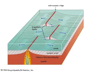
Diagram showing mid-ocean ridge and tectonic plate movement (transform fault)

TTransform Fault

A transform fault is a type of strike-slip fault that occurs at the boundary between two tectonic plates sliding past each other. Transform faults are significant in plate tectonics for accommodating horizontal displacement between plates, commonly found along mid-ocean ridges. 

Reference: Scholz, C. H. (1990). “The Mechanics of Earthquakes and Faulting.” Cambridge University Press.
Share 

Open entry →
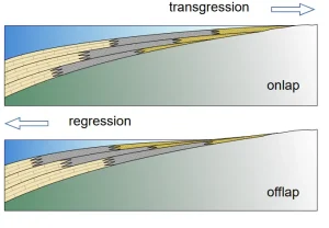
Diagram showing transgression and regression sediment layers

TTransgression

A transgression is a geological event during which sea level rises relative to the land, causing the shoreline to move inland. This process is significant in sedimentology for understanding the deposition of marine sediments, the formation of transgressive sequences, and the changes in coastal environments over time. 

Reference: Catuneanu, O. (2006). “Principles of Sequence Stratigraphy.” Elsevier.

Share 

Open entry →
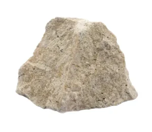
Close-up of a rough travertine rock

TTravertine

Travertine is a form of limestone deposited by mineral springs, especially hot springs. This sedimentary rock is significant in geology for understanding the processes of carbonate precipitation, hydrothermal activity, and the formation of cave and spring deposits. 

Reference: Pentecost, A. (2005). “Travertine.” Springer.

Share 

Open entry →
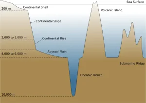
Diagram showing ocean floor topography features (trench)

TTrench

An oceanic trench is a deep, linear depression in the ocean floor formed by the subduction of one tectonic plate beneath another. Trenches are significant in geology for understanding subduction zones, plate tectonics, and the processes that lead to volcanic arcs and earthquake activity. 

Reference: Hilde, T. W. C., Uyeda, S., & Kroenke, L. W. (1977). “Evolution of the Western Pacific and Its Margin.” Tectonophysics, 38(1-2), 145-165.

Share 

Open entry →
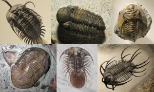
Various fossilized trilobites from different species.

TTrilobite

Trilobites are an extinct group of marine arthropods that lived during the Paleozoic Era, known for their distinctive three-lobed, three-segmented body plan. They are significant in paleontology for understanding the evolution of early life, the diversity of ancient marine ecosystems, and the use of fossils in biostratigraphy. 

Reference: Fortey, R. A. (2000). “Trilobite! Eyewitness to Evolution.” Vintage Books.

Share 

Open entry →
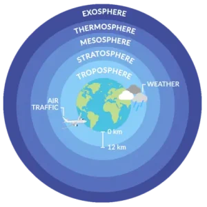
Diagram showing Earth's atmospheric layers (troposphere)

TTroposphere

The troposphere is the lowest layer of Earth’s atmosphere, extending from the surface to an altitude of about 8-15 kilometers. It is significant in meteorology and climatology for understanding weather patterns, climate dynamics, and the interactions between the Earth’s surface and the atmosphere. 

Reference: Wallace, J. M., & Hobbs, P. V. (2006). “Atmospheric Science: An Introductory Survey.” Academic Press.

Share 

Open entry →
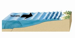
Diagram showing tsunami waves moving toward the coast (Tsunami)

TTsunami

A tsunami is a series of ocean waves with extremely long wavelengths and periods, typically caused by large underwater earthquakes, volcanic eruptions, or landslides. Tsunamis are significant for understanding coastal hazards, oceanography, and the impact of natural disasters on coastal communities. 

Reference: Bryant, E. (2001). “Tsunami: The Underrated Hazard.” Cambridge University Press. 
Share 

Open entry →
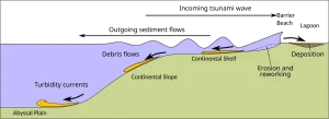
Sediment transport from continental shelf to abyssal plain (Tsunamiite)

TTsunamiite

Tsunamiite is a sedimentary deposit formed by a tsunami, typically characterized by a distinct layer of mixed sediments that may include marine fossils, rip-up clasts, and coarse debris. Tsunamiites are significant in sedimentology for understanding past tsunami events, their sedimentary signatures, and the impacts on coastal environments. 

Reference: Goto, K., Chague-Goff, C., & Jaffe, B. E. (2012). “The Future of Tsunami Research Following the 2011 Tohoku-Oki Event.” Sedimentary Geology, 282, 1-13. 

Share 

Open entry →
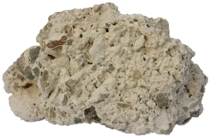
Light porous pumice rock isolated on white background (tuff rock)

TTuff

Tuff is a type of rock made of volcanic ash ejected from a vent during an eruption, which has then consolidated into a solid mass. Tuff is important in volcanology for understanding explosive volcanic eruptions and the deposition of pyroclastic materials. 

Reference: Fisher, R. V., & Schmincke, H.-U. (1984). “Pyroclastic Rocks.” Springer.

Share 

Open entry →
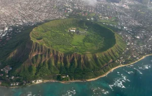
Aerial view of lush volcanic crater near ocean (tuff cone)

TTuff Cone

A tuff cone is a steep, cone-shaped volcanic landform built from the accumulation of volcanic ash and tephra ejected during a phreatomagmatic eruption, where magma interacts with water. Tuff cones are significant in volcanology for understanding the dynamics of explosive eruptions and the formation of volcanic landforms. 

Reference: Heiken, G., & Wohletz, K. (1985). “Volcanic Ash.” University of California Press.

Share 

Open entry →
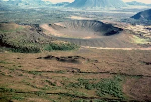
Aerial view of volcanic crater and surrounding landscape (tuff ring)

TTuff Ring

A tuff ring is a low, wide volcanic crater formed by the explosive interaction of magma with water, producing a ring of tuff (consolidated volcanic ash) around the vent. Tuff rings are significant in volcanology for understanding phreatomagmatic eruptions and the formation of volcanic landforms. 

Reference: Lorenz, V. (1986). “On the Growth of Maars and Diatremes and Its Relevance to the Formation of Tuff Rings.” Bulletin of Volcanology, 48(5), 265-274.

Share 

Open entry →
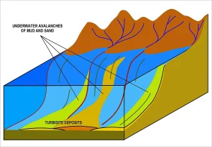
Diagram showing underwater mud and sand avalanches (Turbidite formation)

TTurbidite

A turbidite is a sedimentary deposit formed by turbidity currents, which are underwater flows of sediment-laden water that move down continental slopes and deposit layers of sediment. Turbidites are significant in sedimentology for interpreting deep-sea depositional environments and the history of submarine sedimentation. 

Reference: Bouma, A. H. (1962). “Sedimentology of Some Flysch Deposits: A Graphic Approach to Facies Interpretation.” Elsevier.

Share 

Open entry →

UU-Channel Sampling

U-channel sampling is a technique used in paleomagnetism and sedimentology to extract continuous samples of sediments or rock cores in the shape of a “U,” allowing for detailed magnetic and geochemical analysis. This method is significant for reconstructing past environmental conditions, magnetic field variations, and sedimentary processes. 

Reference: Tauxe, L. (2010). “Essentials of Paleomagnetism.” University of California Press. 

Share 

Open entry →
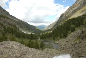
Mountain valley with trees and river under cloudy sky (U-Shaped Valley)

UU-Shaped Valley

A U-shaped valley is a valley with a characteristic U-shaped cross-section, formed by glacial erosion. These valleys are significant in geomorphology for understanding glacial processes, the history of glaciation, and the sculpting of mountain landscapes. 

Reference: Benn, D. I., & Evans, D. J. A. (2010). “Glaciers and Glaciation.” Routledge. 

Share 

Open entry →
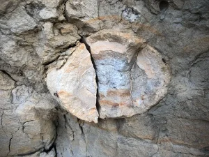
Fossil embedded in layered rock formation (ubiquitous Clay)

UUbiquitous Clay 

Ubiquitous clay refers to the widespread presence of clay minerals in various geological environments, including soils, sedimentary rocks, and hydrothermal deposits. These clays are significant in sedimentology, soil science, and economic geology for their role in soil formation, sedimentary processes, and the development of clay-rich mineral deposits. 

Reference: Moore, D. M., & Reynolds, R. C. (1997). “X-ray Diffraction and the Identification and Analysis of Clay Minerals.” Oxford University Press. 

Share 

Open entry →
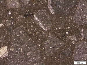
Microscopic view of igneous rock texture (Ultracataclasite)

UUltracataclasite 

Ultracataclasite is a type of fault rock formed by intense mechanical grinding and crushing of rocks along a fault zone, resulting in a very fine-grained, cohesive rock. This material is significant in structural geology for understanding fault mechanics, earthquake processes, and the evolution of fault zones. 

Reference: Sibson, R. H. (1977). “Fault Rocks and Fault Mechanisms.” Journal of the Geological Society, 133(3), 191-213. 

Share 

Open entry →

UUltraconglomerate

Ultraconglomerate is a coarse-grained sedimentary rock composed of very large clasts, often exceeding several meters in size, cemented together. This rock type is significant in sedimentology for understanding high-energy depositional environments, such as alluvial fans and glacial deposits, and the processes of sediment transport and deposition. 

Reference: Boggs, S. (2009). “Petrology of Sedimentary Rocks.” Cambridge University Press. 
Share 

Open entry →
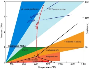
Pressure-temperature diagram of Earth's crust and mantle processes (ultrahigh pressure metamorphism)

UUltrahigh-Pressure Metamorphism 

Ultrahigh-pressure (UHP) metamorphism occurs when rocks are subjected to pressures greater than 2.5 GPa, often during continental collision. UHP metamorphic rocks, such as coesite-bearing eclogite, are significant in geology for providing evidence of deep subduction and the dynamics of crustal processes. 

Reference: Chopin, C. (2003). “Ultrahigh-Pressure Metamorphism: Tracing Continental Crust into the Mantle.” Earth and Planetary Science Letters, 212(1-2), 1-14. 

Share 

Open entry →

UUltrahigh-Temperature Metamorphism

Ultrahigh-temperature (UHT) metamorphism occurs at extreme temperatures exceeding 900°C, often associated with tectonic plate collisions or deep burial of crustal rocks. UHT metamorphic rocks are significant in petrology for understanding the conditions of deep crustal metamorphism, the evolution of orogenic belts, and the processes of crustal melting. 

Reference: Harley, S. L. (1998). “Ultrahigh-Temperature Metamorphism: A New Window on the Thermal Evolution of the Continental Crust.” Geology, 26(4), 315-318. 

Share 

Open entry →
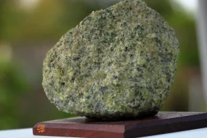
Green peridotite rock on wooden base (ultramafic rock)

UUltramafic Rock

Ultramafic rocks are igneous rocks with very low silica content and high levels of magnesium and iron. These rocks, which include peridotite and dunite, are significant in petrology for understanding the composition of the Earth’s mantle and the processes of mantle melting and magma formation. 

Reference: Le Maitre, R. W. (2002). “Igneous Rocks: A Classification and Glossary of Terms.” Cambridge University Press.
Share 

Open entry →
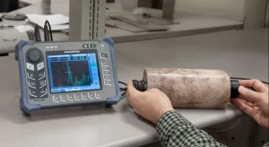
Ultrasonic device testing material sample (ultrasonic attenuation)

UUltrasonic Attenuation

Ultrasonic attenuation refers to the decrease in amplitude of ultrasonic waves as they propagate through a material, often used to characterize the material’s properties. This concept is significant in geophysics for subsurface imaging, detecting fractures, and understanding the mechanical properties of rocks. 

Reference: Krautkrämer, J., & Krautkrämer, H. (1990). “Ultrasonic Testing of Materials.” Springer. 

Share 

Open entry →

UUltrasonic Velocity

Ultrasonic velocity refers to the speed at which ultrasonic waves travel through a material, commonly used in geophysical surveys to characterize rock properties. Ultrasonic velocity is significant in geophysics for understanding the elastic properties of rocks, subsurface imaging, and the detection of fractures and faults. 

Reference: Krautkrämer, J., & Krautkrämer, H. (1990). “Ultrasonic Testing of Materials.” Springer. 

Share 

Open entry →
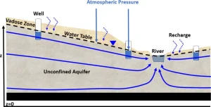
Diagram showing unconfined aquifer and groundwater flow.

UUnconfined Aquifer

An unconfined aquifer is a groundwater reservoir that is directly open to the atmosphere through porous material, such as soil or permeable rock, allowing for the free movement of water. Unconfined aquifers are significant in hydrogeology for understanding groundwater recharge, water table dynamics, and the availability of water resources. 

Reference: Freeze, R. A., & Cherry, J. A. (1979). “Groundwater.” Prentice Hall. 

Share 

Open entry →
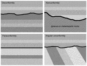
Diagram showing four types of geologic unconformities (disconformity, nonconformity, paraconformity, angular unconformity)

UUnconformity 

An unconformity is a surface within a sequence of layers of sedimentary rock where rock deposition ceased, and erosion removed some previously formed layers before deposition resumed. Unconformities are significant in stratigraphy for understanding geological time gaps, the history of sedimentary basins, and tectonic events. 

Reference: Miall, A. D. (1997). “The Geology of Stratigraphic Sequences.” Springer. 

Share 

Open entry →

join.me

Geology made clear, in your inbox.

Get clear, visual explainers on rocks, minerals, deep time, and the most fascinating parts of Earth science from Geoscopy.
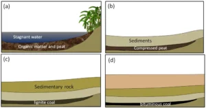
Stages of coal formation from peat to bituminous coal (fossil fuel)

FArchives: Glossary

Fossil fuels are energy resources such as coal, oil, and natural gas, formed from the remains of ancient plants and animals over millions of years under high pressure and temperature. Fossil fuels are a major source of energy globally but are also associated with environmental concerns like greenhouse gas emissions and climate change. Understanding their formation, distribution, and impact is critical in geology, energy studies, and environmental science. 

Reference: Tissot, B. P., & Welte, D. H. (1984). Petroleum Formation and Occurrence. Springer.

Share 

Open entry →