In the early 2000s, petroleum geoscientist Philip Allen noticed a set of concentric rings in 3D seismic data from the southern North Sea and pinned an image to his office wall, hoping someone could explain them. Simon Stewart, then a BP geoscientist, saw it during a visit and suggested an impact origin.
The interpretation remained contested for more than two decades. In September 2025, a new study combined higher-resolution seismic imaging, middle-Eocene biostratigraphy, impact modelling and two shocked mineral grains recovered from 1985 drill cuttings. Together, those lines of evidence make a compelling case that Silverpit formed in a hypervelocity impact.
The 2002 discovery of Silverpit Crater
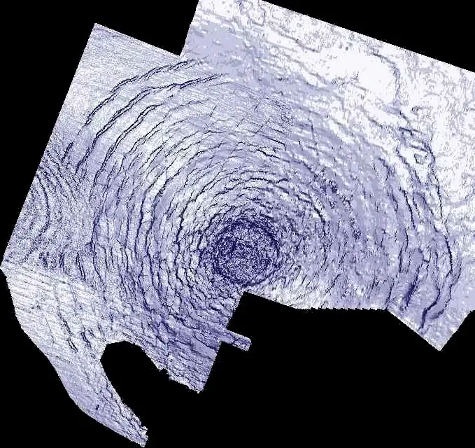
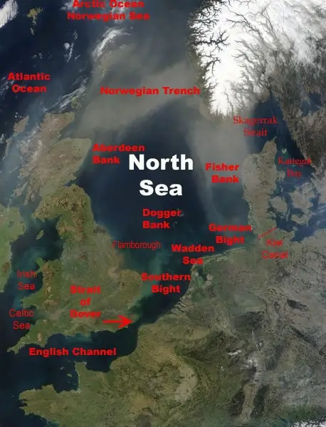
Stewart and Allen published the impact hypothesis in Nature in 2002. They described a 20-km-wide multi-ringed structure with at least ten concentric rings between 2 and 10 km from the centre. If confirmed, it would have been the first impact crater identified in or near Great Britain. Named after the nearby Silver Pit seabed feature, it lies on the UK continental shelf about 130 km (80 miles) off Yorkshire, beneath several hundred metres of younger sediment, the team puts the crater floor around 700 m below the seabed.
Why the Silverpit structure looked like an impact crater
Surrounding those rings were an inner depression and an apparent stratigraphic uplift beneath the crater floor. In a complex crater, the shock briefly makes the rock beneath the crater floor behave like a fluid. It flows upward and inward into the cavity, then freezes in place as the effect dies away, leaving a central uplift. Stewart and Allen initially dated Silverpit to roughly 60–65 million years ago, near the Cretaceous–Paleogene boundary. The geometry was consistent with an impact. It was also consistent with salt withdrawal, and nobody could yet tell the two apart.
The salt-withdrawal theory and the 2009 Silverpit debate
Others read the same data differently. In 2004, University of Edinburgh geologist John Underhill proposed that withdrawal of mobile Upper Permian Zechstein salt at depth had removed support from the overlying strata, allowing them to sag and fault. He developed that intrusion-induced salt-mobility model in a 2009 Petroleum Geoscience paper. Circular collapse and faulting associated with salt movement occur elsewhere in the southern North Sea, and the available seismic data did not then provide a decisive test between the competing interpretations.
On 6 October 2009, the Geological Society of London held the first in a series of Petroleum Group debates, chaired by Channel 4 News science correspondent Julian Rush and sponsored by BP and attended by more than 100 people. Stewart argued that a salt-withdrawal structure should show a traceable collapse profile beneath the feature; Underhill argued that NW–SE dykes related to the Mull igneous centre had mobilised Zechstein salt during the Paleogene. After a 20-minute discussion, the predominantly industry audience voted 80:20 against an impact origin. Nicholson later summed the result up in parliamentary language: the nays had it. Underhill has not moved. Asked about the new study in 2025, he told the Guardian, “I feel like I’m spoiling the party,” adding that the salt explanation is less glamorous but is what the data support. The vote had no bearing on the geology. It closed the question anyway. Research on Silverpit largely stopped for thirteen years.
How the Silverpit investigation restarted
The investigation restarted in late 2022, after a team led by Uisdean Nicholson, a sedimentologist at Heriot-Watt University in Edinburgh, published its first study of the Nadir Crater off West Africa. Nicholson was a PhD student when the vote was held, and remembers it as a well-known debate in geological circles. Ronnie Parr of the North Sea Transition Authority emailed Nicholson and suggested that he revisit Silverpit. Nicholson later told Eos that the earlier controversy had been “a classic, old-school debate” and that “[p]eople simply didn’t believe it was an impact crater.” In a separate essay, he acknowledged that he had accepted the prevailing interpretation without examining the seismic evidence himself.
When Nicholson reviewed the older seismic volumes, the impact interpretation appeared more plausible than he had expected. Parr also pointed him to modern high-resolution 3D seismic data acquired by the Northern Endurance Partnership for a carbon-storage project. The survey covered the proposed central uplift, which critics had suggested might be a stitching artefact in the older patchwork data. The Northern Endurance Partnership data were proprietary, and the team spent several months negotiating access; Nicholson told Eos he begged. The team also obtained cuttings from well 43/25-1, and Gareth Collins at Imperial College London, a co-author on the Nadir work, ran the impact simulations. Parr, whose unsolicited email had restarted the whole thing, is a co-author on the resulting paper.
Shocked quartz and feldspar: the proof of impact
The new survey confirmed that the central uplift and surrounding moat are real geological features rather than stitching artefacts. It also revealed circular depressions roughly 50–150 m across, scattered between the crater rim and about 1.5 km beyond it. They are up to 35 m deep on the lower crater-floor reflection but only about 9 m deep on the upper one. That contrast is why the team thinks they formed during ejecta emplacement, before the returning water partly filled them in. The authors interpret them as probable secondary impact craters formed by ballistic ejecta, while also discussing degassing as an alternative mechanism. Secondary craters are common on the Moon and Mars but are rarely preserved on Earth; a proposed field in Wyoming offers a possible comparison. Nicholson told Eos that the team regarded this as the “first really robust terrestrial evidence for secondary cratering.” The survey also showed elongate features about 250 m by 1 km just inside the rim, interpreted as resurge scars formed as water returned to the crater.
Shock metamorphism is the principal petrographic test for a hypervelocity impact because its diagnostic mineral features require extreme transient pressure. The team therefore examined cuttings from well 43/25-1, drilled by British Gas in 1985 about 1 km northwest of the crater rim. Samples had been collected at intervals of approximately 6 m, wider than the anticipated ejecta layer, and an initial examination found no shocked grains. A sample from 494 m measured depth, close to the team’s preferred tie for the crater-floor-equivalent horizon in the well, contained unusual carbonate-rich material. Nicholson asked Thomas Kenkmann, an impact-cratering specialist at the University of Freiburg who was screening the samples for shock features, to prepare additional slides from that depth.
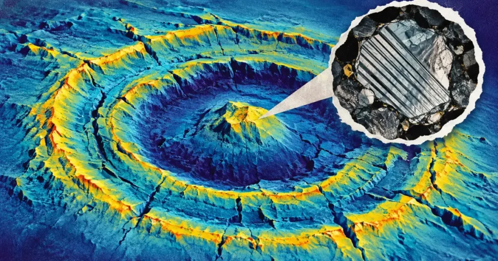
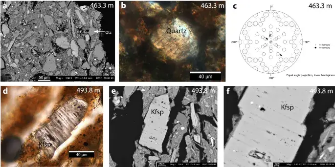
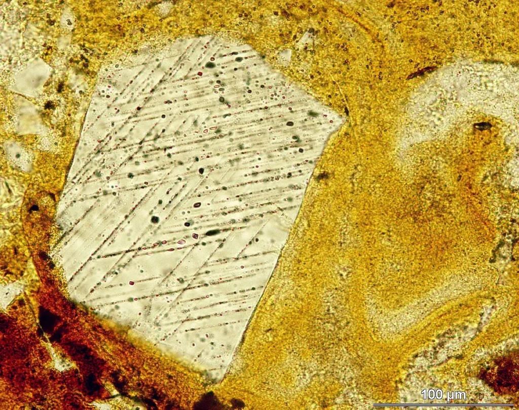
The team identified two grains, 40–80 micrometres wide, containing straight, parallel lamellae decorated by fluid inclusions and spaced 1–7 micrometres apart: quartz at 463 m and potassium feldspar at 494 m. The crystallographic orientations of the quartz lamellae are consistent with shock pressures of 10–13 GPa. The feldspar lamellae have characteristics consistent with shock metamorphism and are interpreted as decorated planar deformation features. The grains are the piece of evidence the 2009 debate had specifically demanded: shock features that no other terrestrial process can produce.
In a Heriot-Watt University press release, Nicholson called the search a “needle-in-a-haystack” effort and said the grains settled the impact question. Collins, who had been in the room for the 2009 debate, said it was rewarding to have finally found the “silver bullet.” The peer-reviewed article uses more measured language, describing the combined seismic, petrographic, biostratigraphic and modelling evidence as compelling.
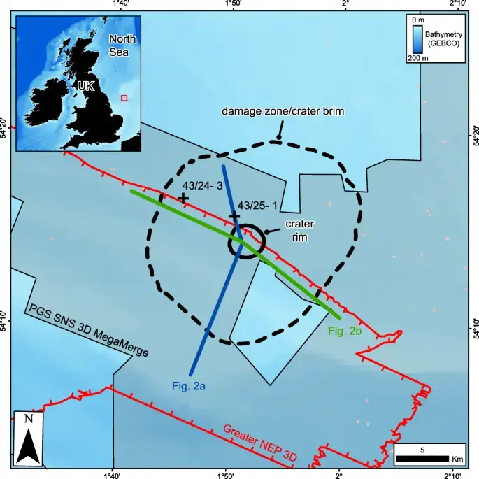
Location map showing the Silverpit crater and its associated damage zone off the Yorkshire coast, with the key 43/25-1 well marked. Credit: Nicholson et al. (2025), Nature Communications 16:8312, CC BY 4.0.
Calcareous nannofossil assemblages from samples tied to the crater-floor horizon place the impact in the middle Eocene. The relevant interval falls within zones CNE10–12, constraining its age to about 46 to 43 million years ago. Stewart and Allen initially proposed an age of roughly 60–65 million years. Wall, Cartwright and Davies argued in 2008 for an Eocene age using biostratigraphy from well 43/25-1, and the 2025 study independently tied the crater-floor reflections to the same interval.
Ruling out salt withdrawal and volcanism at Silverpit
The shocked grains establish that an impact occurred. Ruling out the competing explanations for the structure is the job of the seismic data.
Both the salt-withdrawal model and the later dyke model require the structure to be driven from below, by material either withdrawing or intruding at depth. The new survey shows the opposite pattern. Deformation dies out downwards: faulting is intense through the chalk, narrows to a zone 2.5 km across at the Base Cretaceous unconformity, and stops before it reaches the Triassic. There is no stratigraphic uplift below about 500–700 m beneath the crater floor, and no structural deformation deeper than that. A salt diapir, a withdrawal basin or a volcanic vent would leave a trace all the way down. There is none beneath Silverpit.
The dyke model fails on two further counts. The high-resolution data show no igneous dykes in the vicinity of the crater. And the pit-chain craters elsewhere in the Silverpit Basin that dykes did produce are, on the new age constraint, some 12–16 million years older than Silverpit, and they show no central uplift and no concentric faults. Magmatic diapirs, erosion by bottom currents and gas-escape features are dismissed on the same grounds: none of them produces this architecture.
The authors are explicit that this part of the case stands on its own. The seismic data alone, they argue, provide strong evidence for a hypervelocity impact origin even without the petrography. It is the same argument the group made for the Nadir Crater in 2024, where no rock samples exist at all.
Reconstructing the Silverpit impact
Collins and colleagues ran reconnaissance simulations using a simplified, vertically incident impact. The simulation that best reproduced the nested inner crater, a depression about 1.2 km across sitting inside the 3.2 km rim, used a 160 m rocky impactor with a density of 3,300 kg/m³ and a speed of 15 km/s. The model target comprised 100 m of water, 300 m of weak Paleogene clay, 600 m of brittle chalk, 300 m of ductile mudstone and older sediments below.
The simulation also gives a timeline. Within 12 seconds a transient cavity about 1 km deep and 3 km wide has opened in the seabed, lined with severely shocked clay and chalk. Almost all the material thrown out of it comes from the Paleogene clay, which is stripped down to the chalk inside the crater. That fits what was recovered from the well: silt-sized quartz and feldspar grains in a clay-rich matrix, not fragments of chalk. At about 30 seconds the cavity starts to collapse, the weaker mudstone and the chalk above it rising while the mobile clay slumps inward, widening the transient crater by more than 30%. By 60 seconds the collapse is finished. Water is still pouring back into the hole after two minutes, flooding the cavity and eroding the rim, and sloshing in the shallow, partly enclosed basin probably continued for hours or days afterwards.
At the middle-Eocene horizon, the crater-floor depression is about 3.2 km across. That is far smaller than the 20 km reported in 2002. Much of the gap is definitional: the 2025 team places the rim at 3.2 km and calls the surrounding ring of concentric faults, about 18 km across, the crater brim, a zone of deformation outside the rim, characteristic of impacts into soft marine sediment. The rest is a revision. The earlier figures were mapped at the top of the chalk and assumed a near-end-Cretaceous age, whereas the crater floor is now tied to a middle-Eocene horizon several hundred metres shallower. Stewart and Allen had themselves already revised the rim down to about 8 km in 2005. Beneath it, the Base Cretaceous unconformity forms a stratigraphic uplift about 200 m high, offset roughly 300 m downrange from the centre of the crater floor. The trajectory comes from the asymmetries around that uplift: curved radial faults, normal faults on the western, northern and southern sides against reverse faults in the east, and an axis of bilateral symmetry near 100° from north. Together these point to a low-angle impact from the west-northwest.
A trajectory from the west-northwest creates a problem for the grains. Well 43/25-1 lies about 1 km northwest of the rim, which puts it uprange. Oblique impacts usually leave an uprange forbidden zone, swept clear of ejecta or reached only by material that experienced lower shock pressures, so shocked grains should be scarce on that side. They turned up there anyway. The answer the paper offers is water. Proximal ejecta reaches the position of the well roughly 30 seconds after impact and settles through the water column as a density current, and the resurge and the seiching that followed reworked the seabed for hours or days, distributing material more evenly around the crater than ballistics alone would.
In a Heriot-Watt University press release, Nicholson described a 1.5-km-high curtain of rock and water collapsing into a tsunami more than 100 m high. Those numerical heights do not appear in the peer-reviewed paper. The paper reports that the model generated a “large amplitude, breaking rim-wave tsunami” without assigning it a numerical height.
What the Silverpit evidence proves and what it only suggests
Direct observations include the two shock-metamorphosed grains, the seismic architecture of the structure and the middle-Eocene biostratigraphic age. The outer circular depressions are interpreted as probable secondary craters, and the low-angle trajectory is inferred from structural asymmetry. The estimated 160 m impactor diameter, 15 km/s velocity and tsunami behaviour are model outputs rather than measurements. The authors raise one of the two grains as a caveat themselves. The quartz at 463 m sits about 12 m above the reflection they tie to the crater floor, which is stratigraphically too high for primary ejecta. They cannot completely rule out that it came from a different impact close by in time and space. The explanation they prefer is reworking: seismic sections show deltaic clinoforms above the crater, so this was a mobile shallow-marine setting in which grains could be entrained and moved well after the event. The potassium feldspar at 494 m came from the sample tied to the crater floor itself. The petrographic sample is small, and that is a real limitation. Matthew S. Huber, a planetary scientist at the Planetary Science Institute in Tucson who was not involved in the study, told Eos that finding only one quartz grain and one feldspar grain left room to ask whether the material could have been reworked from another event; he added that the paper could end up being controversial within the impact community. The authors’ case rests on the convergence of seismic, petrographic, biostratigraphic and modelling evidence.
Beneath the crater floor, the top of the chalk is not the sharp peak a complex crater usually produces. It is flat and it is pitted, with depressions between about 50 and 500 m across scattered over both the central uplift and the moat around it. The chalk is also thinner there, roughly 250 m below the crater rim against about 500 m below the outer brim. Assuming an original thickness of 500–600 m, somewhere between 0.9 and 2.2 km³ of rock is missing.
The authors propose that much of it left as gas. Chalk is almost pure calcium carbonate, which decomposes rapidly above about 750 °C into calcium oxide and carbon dioxide, and complete decomposition releases CO₂ equivalent to around 30% of the mass of the original rock. Their simulations put the uppermost 100–200 m of chalk inside the 1 km-wide central uplift above 25 GPa, close to the pressure at which devolatilisation begins once post-shock heating is included. On that reading the chalk under the crater was baked in an instant, and the resulting mixture of carbon dioxide, water vapour, melt and rock fragments escaped upward through the crater floor during the modification stage. Pitted surfaces of similar scale are seen in impact craters on Mars and are interpreted the same way. This remains a model-based interpretation. It needs full three-dimensional oblique simulations, which would also capture the higher vaporisation rates expected in a low-angle impact, and it needs physical samples.
Why marine impact craters like Silverpit are so rare
Impact structures are uncommon in Earth’s surviving geological record because weathering, erosion and tectonic deformation destroy the ones exposed at the surface. Burial works the other way: buried craters are often better preserved, but they cannot be studied without high-resolution seismic imaging or drilling. The 2025 paper cites roughly 200 confirmed terrestrial impact structures in total and about 33 confirmed or probable marine craters; the Earth Impact Database lists 190 confirmed structures, a figure unchanged since 2019, the database has not been substantively updated, rather than no new craters having qualified. The counts differ because the sources use different inventories and thresholds. Oceans cover more than 70% of Earth’s surface, yet only about 33 confirmed or probable marine craters are known, they are inaccessible, usually buried, and identifiable only with seismic imaging or drilling. Silverpit is preserved intact and, unusually, fully imaged, which is why a 3 km crater is getting the attention normally reserved for much larger ones.
How Silverpit compares with Chicxulub and Nadir
Chicxulub is roughly 180 km across and is tied to the end-Cretaceous mass extinction 66 million years ago. Silverpit is two orders of magnitude smaller. Silverpit’s modelled 160 m impactor and 3.2 km crater indicate a major regional event, not an extinction-scale one.
A closer comparison is the Nadir Crater off West Africa, which Nicholson’s group described using 3D seismic data in 2022 and 2024. Nadir has a rim about 9.2 km wide, a brim approximately 22–24 km across and a stratigraphic uplift roughly 425 m high, and it lies near the Cretaceous–Paleogene boundary. Work on Nadir helped prompt the return to Silverpit. Between them, the two structures show how exploration-grade 3D seismic can resolve buried marine impact features in unusual detail.
Why Silverpit matters for planetary defence
A 160 m impactor falls squarely in the size range that concerns planetary defence. It is close in scale to Dimorphos, the asteroid moonlet struck by NASA’s DART spacecraft in September 2022, which measures about 177 by 174 by 116 metres and roughly 151 metres as a volume-equivalent sphere. Congress directed NASA to find at least 90% of near-Earth objects 140 m or larger; Congress set a 2020 deadline, which was missed; as of 2025 roughly 44% of the estimated 25,000 objects in that size range had been found. NEO Surveyor, an infrared space telescope scheduled to launch no earlier than September 2027, is designed to find at least two-thirds of near-Earth objects larger than 140 m during its five-year baseline survey. Silverpit offers a rare geological case study of an object in this approximate size range striking a shallow marine target. In the university release, Nicholson said the findings could help researchers assess the effects of a future impact.
What we still don’t know about Silverpit Crater
Several questions remain open. A fresh core through the crater would provide more extensive and better-controlled petrographic evidence than legacy drill cuttings. The reconnaissance simulations assumed a vertical trajectory, whereas the structural asymmetry suggests an oblique impact from the west-northwest; full three-dimensional oblique simulations are needed to test that interpretation and refine the impactor parameters. The proposed chalk devolatilisation mechanism also awaits confirmation from physical samples. Finally, the central pits and the outer circular depressions are morphologically different and may have separate origins, but both require additional modelling and, ideally, scientific drilling.
More than two decades after its discovery, the 2025 study presents a multi-method case that Silverpit is a middle-Eocene hypervelocity impact structure. The shape had been visible since 2002. What took twenty-three years to arrive was seismic data sharp enough to test it, and two grains of rock, each about as wide as a human hair.
Frequently Asked Questions
Is the Silverpit crater an asteroid crater?
The best current evidence says yes. A 2025 Nature Communications study combines high-resolution 3D seismic imaging, two shock-metamorphosed mineral grains, middle-Eocene biostratigraphy and numerical modelling to build a strong case for a hypervelocity impact. The modelling uses a rocky asteroid, although the geological evidence identifies an impact rather than the object’s composition directly.
How large was the Silverpit asteroid?
Reconnaissance modelling indicates a rocky object about 160 m across, using an assumed density of 3,300 kg/m³ and a speed of 15 km/s. Those values are model inputs that reproduce the inner crater reasonably well, not direct measurements. The estimated diameter is similar to that of Dimorphos.
When did the Silverpit impact occur?
Calcareous nannofossil assemblages tied to the crater-floor horizon constrain the event to approximately 45.95–43.06 million years ago, during the middle Eocene. Earlier studies had placed it closer to the Cretaceous–Paleogene boundary or allowed a broader Late Cretaceous–Eocene interval.
Where is Silverpit crater?
Silverpit lies beneath the southern North Sea on the UK continental shelf, about 130 km (80 miles) off Yorkshire. It is buried beneath several hundred metres of sediment and is named after the nearby Silver Pit seabed feature.
Did the Silverpit impact cause a tsunami?
The numerical model produces a large breaking rim-wave tsunami. A Heriot-Watt University press release describes a water-and-ejecta curtain about 1.5 km high and a tsunami exceeding 100 m, but those numerical heights do not appear in the peer-reviewed paper. They should therefore be presented as press-release estimates based on the modelling, not as measured effects.
Is the Silverpit crater larger than Chicxulub?
No. Silverpit’s crater-floor depression is about 3.2 km across, whereas Chicxulub is roughly 180 km wide and is associated with the global end-Cretaceous mass extinction. Silverpit was a major regional event, but it was far smaller than Chicxulub.