












Introduction
Early on the morning of November 20, 1980, the drilling crew working a floating platform on Lake Peigneur, near New Iberia, Louisiana, had a stuck bit on their hands. Their 14-inch rotary bit had bound up at a drilling depth of about 1,228 feet. That is a nuisance, not an emergency: at such a shallow depth, a stuck bit is usually a routine fix. The men leaned on it. And then, over the next couple of hours, they began to hear things they had never heard before: a series of loud pops from somewhere deep below, and then the unmistakable sensation of the whole rig starting to lean toward the water. They scrambled off and reached the bank. Minutes later the entire platform tipped over and disappeared into a lake that, that morning, was only about ten feet deep.
What the crew had done, though nobody could ever prove it for certain afterward, was drill a hole into the top of a working salt mine. Within about three hours, the lake was gone.
The morning the lake disappeared
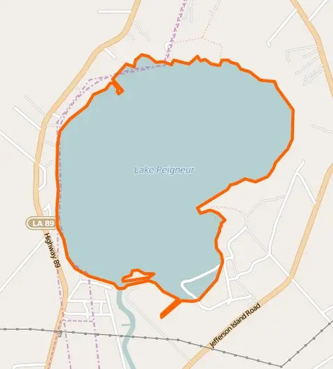
Lake Peigneur in 1980 covered roughly 1,300 acres of Iberia Parish, a plain freshwater lake used for fishing and boating and nowhere more than about ten or eleven feet deep. On its southeastern shore rose Jefferson Island, a low wooded rise crowned by the 1870 home of the actor Joseph Jefferson and by Live Oak Gardens, the tropical garden the Bayless family had planted there. Beneath the lake and the island ran the tunnels of the Diamond Crystal Salt Company mine. Salt had been pulled commercially out of the ground here since at least 1919, first under the Bayless family, who also worked a sulfur deposit in the cap rock from the 1930s. Diamond Crystal, headquartered in St. Clair, Michigan, bought the salt operation in 1956.
Two industries were working the same patch of Louisiana at the same time. Texaco held State Lease 124, covering the mineral rights under the lake, and had subcontracted the Wilson Brothers Corporation to drill an exploratory oil well from a floating platform. Far below, Diamond Crystal miners were cutting salt on several levels, the deepest reaching about 1,500 feet.
When the drill string seized and the pops began, the men on the platform did the smart thing and left. So did the miners underground. The mine’s electrician, Junius Gaddison, noticed a torrent of muddy water spreading across the floor where no water should be, and sounded the alarm. All the miners on shift, 55 of them, rode the single elevator to the surface in an orderly evacuation. Six were later given awards for heroism by Diamond Crystal, including the men who searched the remote workings to make sure no one was left behind.
Above ground, the lake began to move. A whirlpool opened over the puncture and grew until it was estimated at roughly a quarter-mile across, turning slowly at first and then with terrifying speed. It swallowed the drilling platform, then a second rig working nearby, then a barge-loading dock, trucks, trees, and chunks of the shoreline. A fisherman out in a small boat gunned for shore and made it, later reporting that his boat had ended up sitting on mud where the lake floor had been exposed. In the end the disaster killed no people, and there were no serious injuries. Contemporary accounts record the loss of three dogs and nothing more.
What is a salt dome?
To understand why a drill could turn a lake into a drain, you have to go down, a long way down, and a long way back in time.
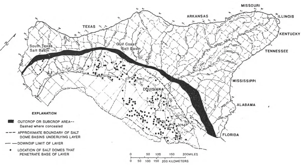
The salt beneath Lake Peigneur belongs to the Louann Salt, a thick evaporite deposited in the Middle Jurassic, traditionally assigned to the Callovian, as North America rifted away from the Yucatán block during the breakup of Pangaea and a young Gulf of Mexico basin repeatedly flooded and dried. That original bed of salt, the “mother bed”, underlies much of the Gulf Coast. At the latitude of the Louisiana coast, the source bed lies deep: Autin, following Kupfer, puts the Louann at roughly 17 kilometers down, and Kumar’s 1982 estimate of perhaps 50,000 feet is the same order.
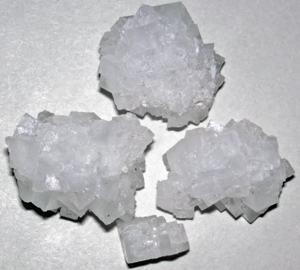
Salt is strange as rocks go. Solid halite has a density of about 2.2 grams per cubic centimeter, and it does not compact under burial the way mud and sand do. Freshly deposited sediment starts out less dense than salt, but as it is buried and squeezed, it compacts and its density climbs past that of the salt. Somewhere around 1.2 to 1.3 kilometers of burial the two densities cross over; deeper than that, the salt is the lighter material, trapped beneath heavier rock. That is an unstable arrangement, and nature resolves it the way a lava lamp resolves a warm blob at the bottom of the glass: the buoyant material rises. Salt also behaves plastically: over geological time it flows like an extremely stiff fluid, so it can creep upward through fractures and weaknesses in the overlying rock, doming and piercing the layers above it. Geologists call the rising column a diapir, from a Greek word meaning “to pierce.”
As a diapir climbs, it drags and bends the surrounding strata upward along its flanks. Those upturned, faulted layers make excellent traps for oil and gas, which is exactly why oil companies have always paid close attention to salt domes, and why Texaco was drilling next to one. The top of a Gulf Coast dome is often capped by a “cap rock” of anhydrite, gypsum, and limestone left behind as groundwater dissolves the crest of the salt, and some domes carry commercial sulfur in that cap.
Jefferson Island and the Five Islands
Jefferson Island is the northernmost of a line of five salt domes strung along a northwest–southeast trend near the western edge of the Mississippi River delta plain:Jefferson, Avery, Weeks, Côte Blanche, and Belle Isle. Locals call them the Five Islands, though none of them is surrounded by water. They are hills, the only substantial relief for miles in a landscape of marsh and coastal plain, pushed up where the rising salt domed the ground above it.
The geologist Whitney J. Autin, whose 2002 paper is the most thorough modern treatment of these features, described them as salt structures rooted kilometers below that held their position near the surface while the ground on either side of them subsided. Their surfaces carry the fingerprints of both processes: unusually steep slopes and fractured surface sediments where the salt has pushed up, and ponds, saddles, and collapse structures up to a kilometer across where it has dissolved away. The mechanism that built them is called downbuilding, a concept traced to Barton in 1933 and Murray in 1961, in which the salt column effectively stays near the surface while the basin sinks around it, sediment piling into the withdrawal areas alongside.
Avery Island, the largest of the five, is the most famous: it is the home of Tabasco sauce and often described as the highest point on the Gulf Coast, at about 163 feet. Jefferson Island is more modest, its crest reaching roughly 75 feet above sea level. In 1982 the geologist Madhurendu B. Kumar, writing for the Houston Geological Society, described Jefferson Island as a peninsula of higher ground jutting into the lake.
How the mine flooded
The Diamond Crystal mine used the room-and-pillar method: miners cut a grid of enormous corridors, each roughly 100 by 80 feet, on several levels down to about 1,500 feet, leaving thick columns of salt in place to hold up the ceilings. It was, in effect, a series of vast, dry, cathedral-like chambers carved into the salt stock.
When the drill assembly punched through into one of those chambers, it opened a path between a ten-foot-deep lake and a mostly empty void more than a thousand feet below. The likely breach point was a mined-out room on the mine’s 1,300-foot level. That was Diamond Crystal’s contention in its lawsuit, and MSHA’s investigators produced their own estimate of the drill hole’s location; Texaco’s side never conceded it.
Here the geology turned a small hole into a catastrophe. The lake was fresh water; the walls of the hole were salt. Fresh water dissolves salt with enthusiasm. As lake water poured down the initial puncture, it ate away the salt around it, and the hole widened, which let more water through, which dissolved more salt, a runaway feedback that no one could stop. The rushing water also carved away the soil and rock around the opening, and it undermined the salt pillars holding up the roof. As those pillars dissolved and failed, sections of the mine roof collapsed, enlarging the cavity into which the surface could sink.
Air trapped in the flooding mine had to go somewhere, and it blew back up the mine shafts, first as blasts of compressed air and then, according to the History Channel’s Modern Marvels, as geysers reaching 400 feet. Popular accounts say roughly 3.5 billion gallons of water drained away in about three hours. The figure is worth flagging: it traces to journalism rather than to any hydrological measurement. Its most influential appearance is Alan Bellows’s widely read 2005 account, which has the lake drained of “most of its 3.5 billion gallons” after three hours. Some accounts cite lower volumes, of 1.5 to 2.5 billion gallons. The spread is the tell: this is an unmeasured estimate, not a gauged value.
The whirlpool eventually pulled down eleven barges, a tugboat, and both drilling platforms. Then, once the mine had filled and the water pressure below equalized with the water above, the disaster performed one last trick. Days later, nine of the eleven sunken barges rose back to the surface on their own. The drilling rigs and the tug stayed entombed in the ruined mine.
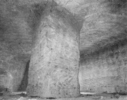
Underground salt mining at nearby Avery Island in 1933. Diamond Crystal’s Jefferson Island mine used the same room-and-pillar approach, leaving salt columns to hold up the roof, columns that dissolved once fresh water poured in. USGS (1933), Public Domain.
The reversed canal and the lost land
Lake Peigneur normally drained southward through the Delcambre Canal, also called Bayou Carlin, a channel roughly 12 miles long that carries the local shrimp fleet down to Vermilion Bay and the Gulf. With the lake suddenly emptying into the mine, the canal’s flow reversed: instead of draining the lake to the sea, salt water from the Gulf now rushed north to refill the crater. Where the reversed canal spilled into the drained basin, it briefly formed the tallest waterfall ever recorded in Louisiana. Sources disagree on its height. Two sources give 150 feet, 64 Parishes, the Louisiana Endowment for the Humanities encyclopedia, and Bellows’s account, while the History Channel’s Modern Marvels puts it at 164 feet. Either way it was a temporary feature, lasting only as long as it took the Gulf to top off the newly deepened lake.
The land loss was permanent. Popular accounts usually say about 65 acres of shoreline were swallowed, including a large piece of Jefferson Island and part of Live Oak Gardens. The figure in the geological literature is more precise: in a 1984 paper for the Gulf Coast Association of Geological Societies, Autin put the loss at 68.2 acres (27.6 hectares) of land along the southeastern margin of the lake, attributing it to a collapse sinkhole that began with an instability deep underground and cascaded into a series of landslides and mudflows at the surface.
The collapse is why the lake never went back to what it was. When the water returned, it filled not the old shallow basin but a deep crater over the drained and collapsed mine. Lake Peigneur today has a maximum depth of about 200 feet (60 meters), against a former depth of about ten feet, making it the deepest lake in Louisiana. It is brackish now rather than fresh.
Who was to blame?
This is the question everyone asks, and no investigation has ever settled it.
The evidence that would have pinned down exactly where the drill went, and exactly where the mine wall stood, was destroyed in the flood. The generally accepted reconstruction is that the drilling operation was in the wrong place relative to the mine, the result of a surveying or triangulation error, and that the bit therefore pierced the mine roof. But the alternative has never been ruled out: that the mine’s own maps of where its workings extended were inaccurate.
The federal investigation reached the same wall. The U.S. Mine Safety and Health Administration produced the official report, The Jefferson Island Mine Inundation, in 1981, authored by Marvin W. Nichols, Jr. and colleagues. Its conclusion is notably candid about the limits of what could be known. In the report’s own words, at page 57: “Because it was impossible to inspect the flooded mine workings, and because of the circumstantial nature of the information available, it would be extremely difficult to determine the precise cause of the inundation.”
The lawyers were less circumspect than the geologists. Diamond Crystal sued Texaco for $260 million; Texaco countersued. Diamond Crystal contended that Wilson Brothers had triangulated the well’s position incorrectly. Wilson Brothers’ attorney went further: after more than two years of investigation, he said, a number of experts had concluded that the well never drilled into the salt mine at all. In July 1983 the parties settled out of court. According to United Press International reporting at the time, Diamond Crystal accepted $32 million from Texaco and Wilson Brothers, with Wilson Brothers paying 6.25 percent and Texaco the remainder. Separately, J. L. Bayless, the Live Oak Gardens Foundation, and Live Oak Gardens Ltd. received $12.8 million from Texaco (70 percent), Diamond Crystal (25 percent), and Wilson Brothers (5 percent). A $45 million figure circulates widely, 64 Parishes gives it as a Texaco payment to Diamond Crystal, and Bellows’s account gives it as Diamond Crystal’s combined recovery. The contemporaneous UPI report is the better authority, and the arithmetic suggests where the larger number came from: $32 million plus $12.8 million is $44.8 million. It is the two settlements added together, not a third payment. Class-action suits brought by miners and other employees were still outstanding at the time of the settlement and were not part of these agreements.
Lake Peigneur today
The Diamond Crystal mine never reopened as a salt mine; it was formally closed in December 1986. But the salt dome did not stop being useful. Since 1994 the dome beneath Lake Peigneur has been used as an underground storage and hub facility for pressurized natural gas, operated by Jefferson Island Storage & Hub, LLC (JISH). AGL Resources of Atlanta bought the facility from an American Electric Power subsidiary in 2004; AGL itself became Southern Company Gas in 2016, and JISH remains one of its subsidiaries today. As the company described it in a 2010 permit-application release, JISH “currently operates two natural gas storage caverns in the Jefferson Island salt dome approximately 4,000 feet below the surface of Lake Peigneur,” caverns it said had operated safely since 1994. (Company releases from 2007 put the same two caverns at approximately 3,000 feet; the 4,000-foot figure comes from the later application.) The gas is pumped into caverns solution-mined in the salt, the same buoyant, impermeable rock that made the region attractive to oil explorers in the first place.
A proposal to add a third and fourth cavern, which would have raised working gas capacity from roughly 8 billion cubic feet to about 20 billion cubic feet, drew organized opposition from the local group Save Lake Peigneur, Inc. Solution mining new caverns means pumping in enormous volumes of fresh water, and the group’s central objection was the risk to the Chicot aquifer, the area’s main source of drinking and agricultural water, alongside safety concerns for the roughly 4,000 residents living within a mile of the facility. The fight reached the courts: in 2014, Judge Keith Comeaux of the 16th Judicial District Court reversed the Louisiana Department of Natural Resources’ decision to issue a coastal use permit for the two new caverns. As of this writing the expansion has not been built.
The lake itself is calm now, ringed by private land and viewable mainly from the restored Rip Van Winkle Gardens on Jefferson Island. A brick chimney still protrudes from the water, a marker of what the flood took. The gardens, badly damaged in 1980, were rebuilt at a fraction of their former acreage.
The geology has not settled down. Louisiana’s salt domes are not inert. A 2021 study in Frontiers in Environmental Science counted 153 known terrestrial salt domes in the state and noted that two of them have produced human-influenced collapse sinkholes: Lake Peigneur in 1980 and Bayou Corne, on the Napoleonville dome, in 2012. From that the authors derive an annual probability that any one dome produces such a collapse of roughly 0.025 percent, two events among 153 domes over 52 years, a frequency they compare to that of damaging earthquakes in western North America. Autin, for his part, has emphasized that uplift of the Five Islands is probably still active, leaving open the possibility of future geomorphic instability.
Lake Peigneur is now a case study in what happens when two industries reach for the same slug of Jurassic salt from opposite directions, in a place where the ground has been rising for a hundred million years and can still fall in an afternoon.
Frequently asked questions
What caused the Lake Peigneur disaster?
A Texaco-contracted oil rig, operated by Wilson Brothers, is believed to have drilled a 14-inch hole into the Diamond Crystal salt mine beneath the lake, probably because the well was in the wrong place relative to the mine. Fresh lake water then poured into the mine, dissolving the salt and enlarging the hole until the entire lake drained. The 1981 MSHA report could not determine the precise cause because the flooded mine could never be inspected.
Did anyone die at Lake Peigneur?
No people died and there were no serious injuries. The drilling crew escaped the platform, all 55 miners on shift evacuated via the mine’s single elevator after electrician Junius Gaddison raised the alarm, and a fisherman on the lake reached shore. Contemporary accounts record the loss of three dogs.
How deep is Lake Peigneur now?
Before 1980 it was about ten feet deep. The collapse of the mine created a deep crater, and the refilled lake now reaches a maximum depth of about 200 feet, making it the deepest lake in Louisiana. It is also now brackish rather than fresh.
Can it happen again?
It can, in principle. A 2021 Frontiers study estimated a roughly 0.025 percent annual probability of a collapse sinkhole forming on a Louisiana salt dome, based on two events (Lake Peigneur in 1980 and Bayou Corne in 2012) among 153 known onshore domes. Both were human-influenced. The salt dome under Lake Peigneur is now used for natural gas storage, which is why proposed expansions have drawn local opposition.
What is a salt dome?
A salt dome is a column of salt that has risen buoyantly through overlying rock. Salt is less dense than compacted sediment and flows plastically over geologic time, so buried salt tends to rise and pierce the layers above it in a process called diapirism. On the Louisiana coast, the salt comes from the Jurassic Louann Salt, and the Five Islands, including Jefferson Island, are surface expressions of such domes.