
Introduction
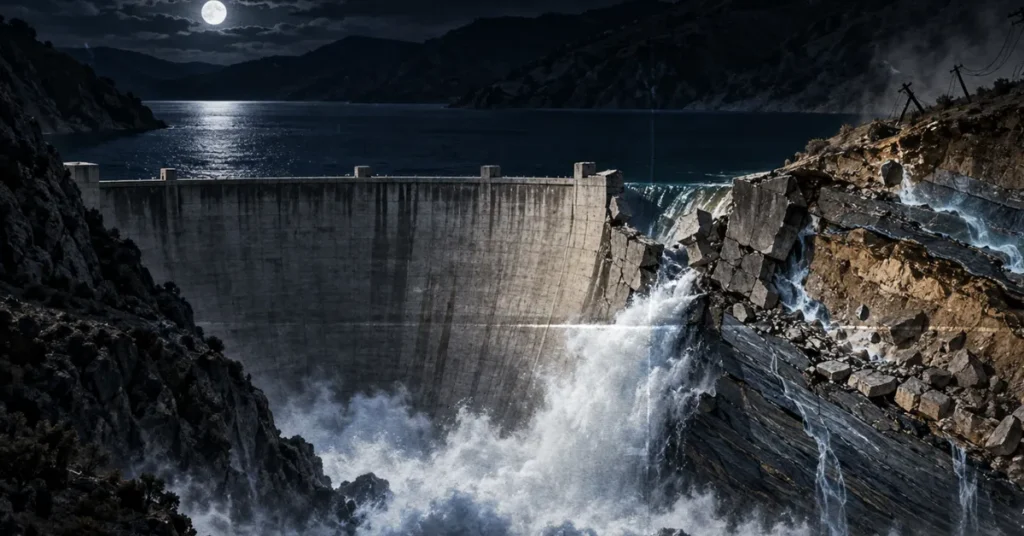
A carpenter named Ace Hopewell rode his motorcycle up San Francisquito Canyon Road a few minutes before midnight on Monday, March 12, 1928. He was headed for Power House No. 1, high in the canyon about forty miles northwest of downtown Los Angeles, and his route took him past the St. Francis Dam, a 205-foot wall of concrete that had been finished less than two years earlier and whose reservoir had been filled to the brim for the first time only five days before. He rode by without a second look. A mile or more beyond the dam he heard a low, grinding rumble behind him, the kind of sound a rockslide makes, and rockslides were ordinary in that canyon. He stopped, listened, and rode on. Hopewell was the last person to see the St. Francis Dam standing and live to tell anyone about it.
The moment itself survives in an electrical record. At 11:57:30 that night the lights dipped across Los Angeles, fifty miles away, and operators at the city’s Bureau of Power and Light logged a sharp two-second drop in voltage. At the Southern California Edison substation in Saugus, a transmission line to Lancaster shorted out and blew an oil switch. That line ran on tandem poles across the hillside above the dam’s east end. Something had just torn the poles down. Behind the dam sat a reservoir of 38,168 acre-feet, about 12.4 billion gallons, held by a structure that its builder had walked across that very morning. By a few minutes after one o’clock the reservoir was empty. The water it released ran for roughly 54 miles down San Francisquito Canyon and the Santa Clara River Valley and reached the Pacific Ocean near Ventura about five and a half hours later, still carrying the wreckage of towns and work camps. At least 400 people died, and by some counts more than 600. The figure most often cited today is 431 or more.
The detail that has haunted the story for nearly a century is the man at the foot of the dam that morning. William Mulholland, the self-taught chief engineer who had built the Los Angeles Aqueduct and made the modern city possible, drove out after the damkeeper telephoned about a leak running muddy. Mulholland and his assistant Harvey Van Norman spent about two hours at the dam, decided the leak was nothing unusual, and returned to the city. Twelve hours later the dam was gone. The deeper reason was not understood for decades, and no one on the site that morning could have seen it: the dam’s east end had been anchored to an ancient, long-dead landslide in a slippery rock called Pelona Schist, and the rising reservoir had quietly brought that landslide back to life.
Where was the St. Francis Dam?
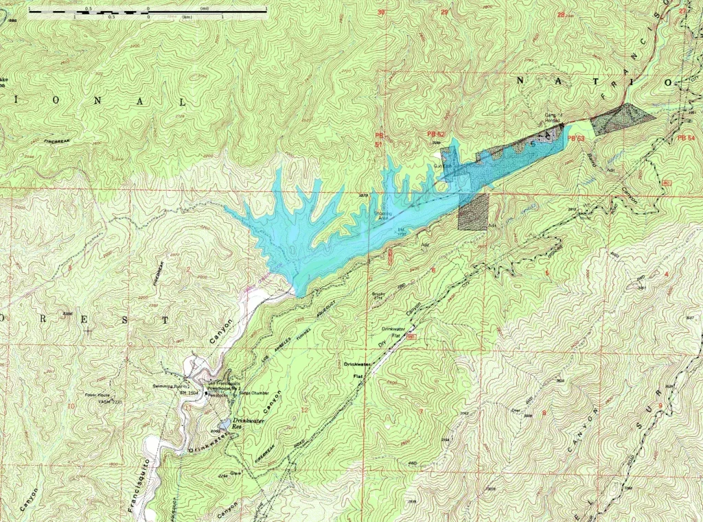
The dam stood in San Francisquito Canyon, in the Sierra Pelona Mountains of northern Los Angeles County, about ten miles north of the present city of Santa Clarita and roughly forty miles from downtown Los Angeles. San Francisquito Creek runs south through the canyon toward the Santa Clara River, and the river turns west from there and flows through Ventura County to the sea. Two hydroelectric plants, Power House No. 1 above the dam site and Power House No. 2 below it, were already in the canyon when the dam was built. Both belonged to the Los Angeles Aqueduct, and the reservoir was placed between them so that water could be stored on its way down to the city.
The dam only makes sense as a piece of that aqueduct. Los Angeles had about 102,000 residents in 1900 and no river worth the name. By 1920 the population had passed 576,000, and by 1930 it would pass 1.2 million. The growth ran on water that fell as snow in the Sierra Nevada, gathered in the Owens River 230 miles to the north, and reached the city through the aqueduct that Mulholland finished in November 1913. Some 40,000 people watched the first water come down the cascades into the San Fernando Valley that day, and Mulholland’s entire speech was a single sentence: “There it is. Take it.”
The aqueduct made the city, and it also made the city fragile. The whole supply ran through one channel that crossed the San Andreas Fault by way of the Elizabeth Tunnel, and Mulholland worried openly that an earthquake could cut it. Through the early 1920s, a run of near-record dry years pressed the point. Rogers, the engineering geologist whose work anchors the modern understanding of the failure, notes that the Bureau of Water Works and Supply built or enlarged nine reservoirs between 1920 and 1926, and St. Francis was the largest of them. In June 1922 Mulholland promised the city’s Board of Public Service Commissioners a reservoir south of the San Andreas that could hold an entire year’s supply.
Then the aqueduct’s enemies gave him a second reason. Farmers and townspeople in the Owens Valley, watching their lake and their livelihoods drain south, turned to sabotage. On May 21, 1924 a party of men dynamited the aqueduct spillway gate near Lone Pine. That November, several dozen armed ranchers seized the Alabama Gates and opened them, dumping the city’s water back into the dry riverbed while crowds picnicked on the bank. More attacks followed through 1927. A big reserve close to Los Angeles, on the safe side of the fault and out of the valley’s reach, stopped being a convenience and became, in Mulholland’s mind, insurance.
He had looked at San Francisquito Canyon long before. A construction camp had been set up there in 1911 while crews bored six and a half miles of aqueduct tunnels through the Pelona Schist between the future sites of the two power houses. Mulholland liked the canyon’s shape: a wide upstream basin that pinched down to a narrow throat, so that a relatively short dam could hold back a great deal of water. Cheap land and a site already served by roads and power lines sealed the choice. Surveying began in 1922, and by the summer of 1924 concrete was going in. What Mulholland could not know was why the canyon had that convenient shape. The natural constriction was itself the leftover of an ancient landslide that had once dammed the creek, a clue that would take more than sixty years to read.
What a gravity-arch dam is, and what this one actually was
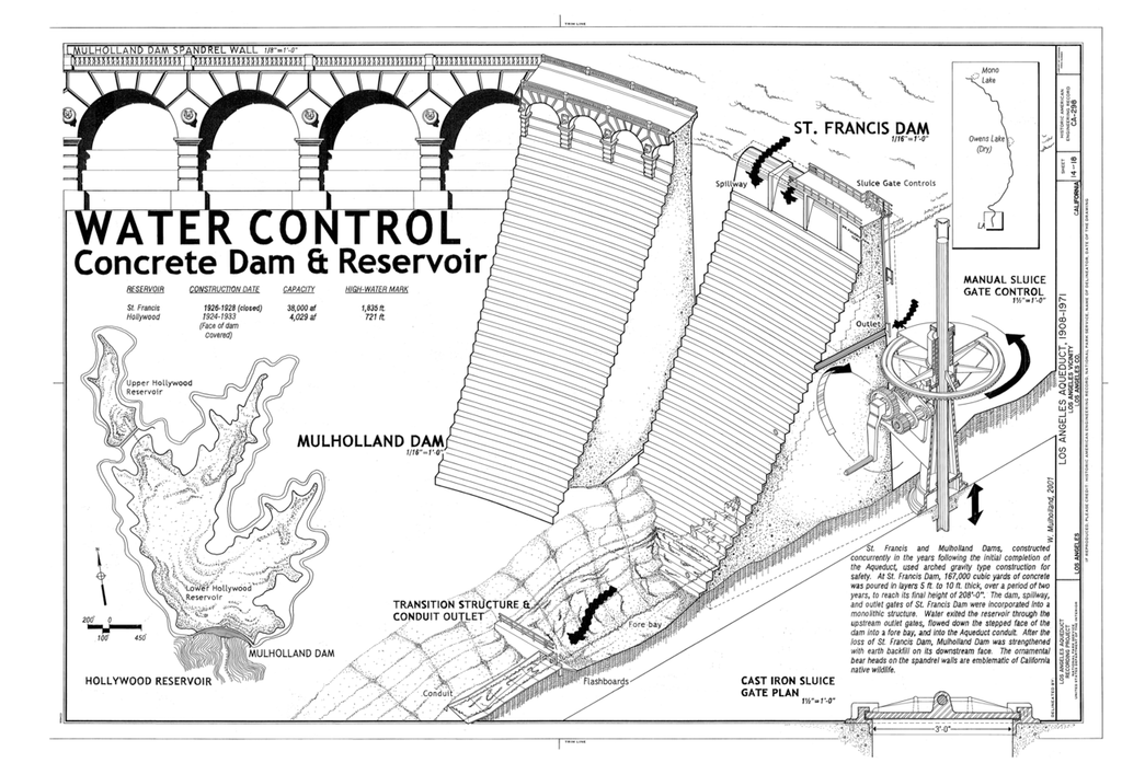
A concrete gravity dam holds back water mainly by being heavy, the way a person holds a door shut against a crowd by leaning their whole weight into it. Its own mass presses down on the bedrock, and that downward press does two jobs at once: it keeps the dam from tipping over, and it creates the friction along the base that keeps the dam from sliding downstream. A gravity-arch dam adds a curve. Bent upstream in plan, the dam can pass some of the water’s push sideways into the canyon walls, the way a stone arch bridge carries its load out into its abutments. The St. Francis Dam was curved, and modern engineers would call it an arch-gravity structure, but in the mid-1920s the mathematics of arch action was so new that its designers ignored the help the curve gave them. They sized it as a plain gravity dam and treated the arch as a bonus. That made the cross-section look conservative for its height. It was not.
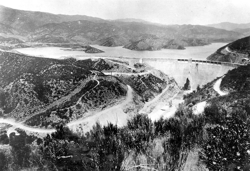
The dam was the second concrete dam the Bureau had ever built. The first was its near twin in Weid Canyon above Hollywood, completed at the end of 1924, dedicated in March 1925 and christened Mulholland Dam, the structure that still holds Hollywood Reservoir. Rogers, who spent years reconstructing the design history, found that Mulholland Dam had been laid out by a Bureau office engineer named Edgar A. Bayley following the worked examples in the standard textbooks of the day, with no cores or tests of the foundation rock and no formal calculations. The St. Francis design was that design carried over to a new site with minor changes. Nobody, in Rogers’s phrase, claimed credit for having designed it.
On paper the finished dam was formidable. It rose 185 feet above the streambed and 205 feet above the deepest point of its foundation. The curved main section ran roughly 700 feet along the crest, and a 588-foot wing dike continued along the ridge west of the canyon to hold the enlarged reservoir. The crest was 16 feet thick. The base, on the cross-section handed to investigators, was about 176 feet thick. About 130,000 cubic yards of concrete went into it, mixed on site from canyon gravel and placed from inclined troughs in five-foot lifts. The downstream face was built as a staircase of shallow steps, each a little narrower than the one below, a feature shared with Mulholland Dam that later helped investigators identify where each shattered block had come from. Eleven spillway panels sat along the crest, and five 30-inch outlet pipes could pass a combined 1,184 cubic feet per second when the reservoir was full. Construction had begun in the summer of 1924, and the dam was declared complete in May 1926.
Why a dam holds, and how it lets go
Two families of force fight over every gravity dam. On one side is the dam’s weight, pushing straight down, pinning it to the rock and generating the friction that stops it sliding. On the other is water: the horizontal shove of the reservoir against the upstream face, and a quieter push that comes from underneath and is described in its own section below. A safe dam is one where weight and friction win by a wide margin, so wide that engineers describe it as a factor of safety, the ratio between what the dam can resist and what the water can throw at it. The 1920s convention was to check that the combined push and weight produced a resultant force that fell within the middle third of the dam’s base, which is the condition for a block that will neither tip nor lift at its upstream heel.
A dam does not need to be shoved over in one piece. It only needs to lose enough of its margin that a single weak link starts a chain the rest cannot stop: a seam of softened rock, or a crack that lets water reach the heel. Once part of a dam moves, the water finds the gap and does the rest at a speed no one can react to. That is the general lesson of gravity-dam failures. The specific lesson of St. Francis is what happened to each of those margins in the two years after the reservoir began to fill.
The base that never got wider
The first design decision investigators seized on came during construction. The dam had been planned in 1923 to rise 175 to 180 feet. In July 1924, shortly after work began, Mulholland ordered it raised ten feet to store more water. In July 1925 he ordered another ten. Together the two changes made the dam about 11 percent taller than planned. Raising a gravity dam changes its arithmetic, because a taller dam holds deeper water and deeper water pushes harder, and the push grows with the square of the depth. To keep the same factor of safety the base normally has to grow wider, so the structure stays heavy enough for the greater load. At St. Francis the base was never widened. The extra twenty feet of height were stacked on a footprint sized for a shorter dam, and the factor of safety against overturning fell accordingly.
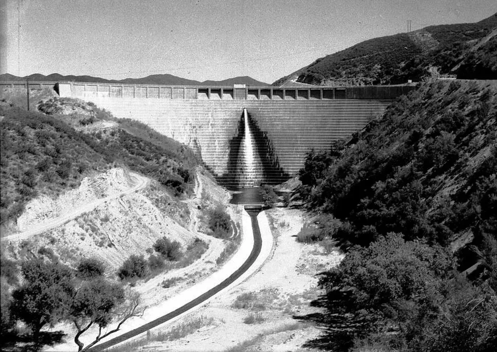
The base was also thinner than the drawings said. Charles Outland, the Santa Paula historian whose 1963 book remains the essential account of the disaster, noticed in a construction photograph that the downstream toe had been chopped off below elevation 1,650 feet rather than carried out to the full profile. Rogers’s reconstruction suggests the real base was closer to 152 feet than the 176 feet on the section given to the Governor’s Commission. Nor had the upstream face been battered, or sloped outward, below elevation 1,645 as the official section implied. In the center of the canyon the upstream part of the foundation was excavated eight feet shallower than the rest and never reached bedrock at all. Each of these choices shaved a little more off a margin that was already smaller than anyone at the Bureau realized, because the design method they had borrowed from textbooks assumed the concrete was perfectly dry and the rock beneath it perfectly tight. Neither assumption held in San Francisquito Canyon.
What caused the St. Francis Dam to fail
Most modern engineers and geologists agree on the short version: the dam was built on ground it should never have trusted, and filling the reservoir for the first time turned that ground against it. Which side of the canyon gave way first has been argued for nearly a century, and that argument gets its own section below.
The east abutment was a fossil landslide in Pelona Schist
Engineers name the sides of a dam as seen looking downstream, so at St. Francis the left abutment was the east side of the canyon and the right abutment was the west. The east side is Pelona Schist. Schist is a metamorphic rock, which means it began as something else, in this case sand and mud on an ancient sea floor, and was then buried, heated, and squeezed until its minerals recrystallized. The squeezing lines up flaky minerals such as mica into parallel sheets, and those sheets give schist its defining habit: it splits along the flat mica layers the way a wet deck of cards slides apart when you press on it at an angle. When the layers are tilted toward a valley and wet, they make treacherous foundation rock, because the whole hillside wants to slide along its own grain.
The Pelona Schist has a long biography. Its sediments were laid down in the Late Cretaceous, roughly 70 to 80 million years ago, dragged deep beneath the edge of the continent in a subduction zone, cooked and flattened there, and later hauled back to the surface along faults in the Transverse Ranges. Aqueduct crews had met it a decade before the dam and had not enjoyed the experience. Workers boring the San Francisquito tunnels complained that the schist dipped dangerously and swelled when it was exposed to air, and they called it “heavy ground,” a phrase the historians Norris Hundley Jr. and Donald C. Jackson later used as the title of their book on the disaster. During the dam’s own site work, Bureau crews blasted a tunnel about 30 feet long into the schist of the east abutment to see what it was like, and left it open until construction began, which can only have loosened the slope further.
The weakness of the rock was only half the problem. The whole hillside above the east abutment was itself an ancient landslide, a mass of schist that had broken loose and slid downhill sometime in the Pleistocene, come to rest, and sat there for tens of thousands of years looking, to a hurried eye, like solid mountainside. Geologists call this a paleo-landslide, a fossil slide, and it behaves like a boulder balanced on a slope: stable for as long as nothing changes the balance of forces holding it, and ready to move the moment something does. The benches and terraces that step up the flanks of the Sierra Pelona are the tops of old slide blocks. At various times in the past 100,000 years these slides had blocked San Francisquito Creek, ponding a lake behind them and filling the canyon floor with lake mud and river gravel. The glen of big trees on the reservoir floor grew on those deposits. The narrow throat that made the canyon such an attractive dam site was, in Rogers’s reading, the remnant of one of those natural landslide dams.
One geologist saw it within weeks. Bailey Willis of Stanford, retained with Carl Grunsky by the Santa Clara River Protective Association, a downstream landowners’ group after the collapse, walked the slopes above the dam and noticed a series of stepped tension cracks cutting across the Bee High Line Road, about 200 feet above the reservoir’s high-water line. He drew a sketch showing the 1928 slide as the toe of a far larger and deeper paleo-landslide complex in the schist. His reading was pushed aside at the time. Outland revived it in 1963, and Rogers built it into a full forensic reconstruction in the 1990s, mapping the foliation and joints of the schist in the field and running them through rock-mechanics software. Rogers’s work later prompted a U.S. Geological Survey inventory, released in 2006, that found at least 153 dams in the United States, and 254 worldwide, that had been built on or against landslides without anyone knowing it. St. Francis was the case that taught the profession to look.
Pore pressure: how a full reservoir woke the slide up
Rock is full of holes. Even hard rock is threaded with pores and cracks, and a fractured, foliated schist is more sponge than brick. When a reservoir rises against a hillside, water seeps into those openings and the pressure of the water trapped inside the rock climbs with the depth of the lake outside. Engineers call it pore pressure. It matters because the strength of a slope comes from friction between grains and blocks of rock, and friction depends on how hard those pieces are pressed together. Water pressure inside the pores pushes the pieces apart, so it steals part of the pressing force and the friction drops. It is the same reason a stack of paper slides apart once a film of water gets between the sheets, and the reason a hillside that stood for a thousand dry years lets go after a week of rain. The rock does not have to dissolve or crumble. The water inside it simply carries part of the load that the grain-to-grain contacts used to carry.
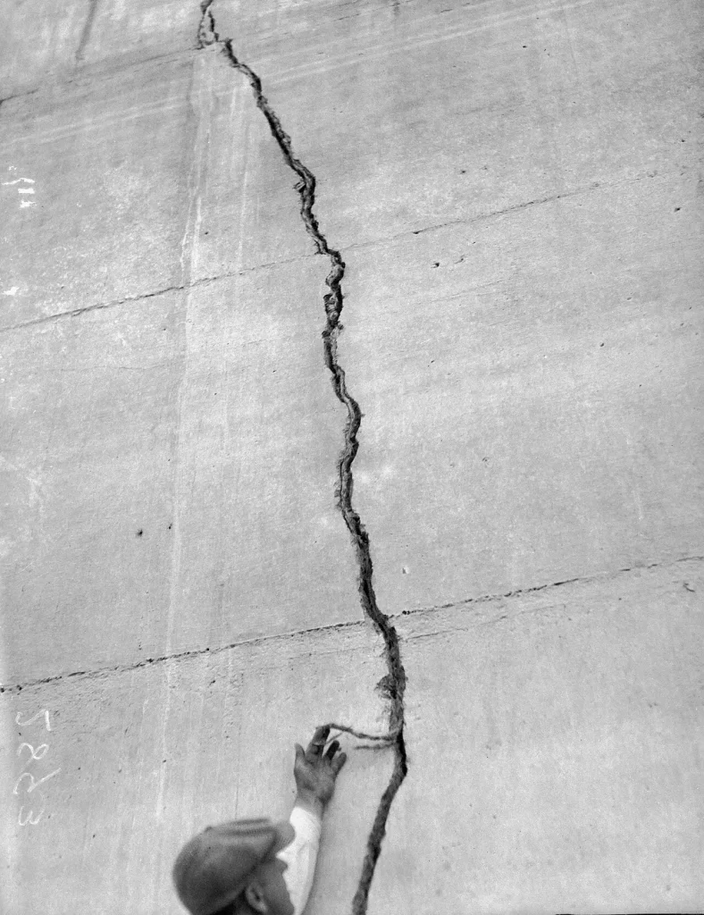
The St. Francis reservoir filled in stages. In the summer of 1926 the pool was brought up 110 feet, to elevation 1,780, and drawn down about 20 feet over the winter. In early 1927 it was raised another 52 feet, to within three feet of the spillway sills, held there for about three weeks in May, then drawn down through the fall. Cracks appeared in the concrete during the first year, most of them the expected work of heat from the setting cement and the contraction that follows. Four prominent joints leaked enough to need grouting, and Mulholland ordered them caulked with oakum, a tarred hemp fiber, so the grout would stay put. Rogers regards that caulking as one of the worst things anyone could have done, because it trapped water inside the concrete instead of letting it drain.
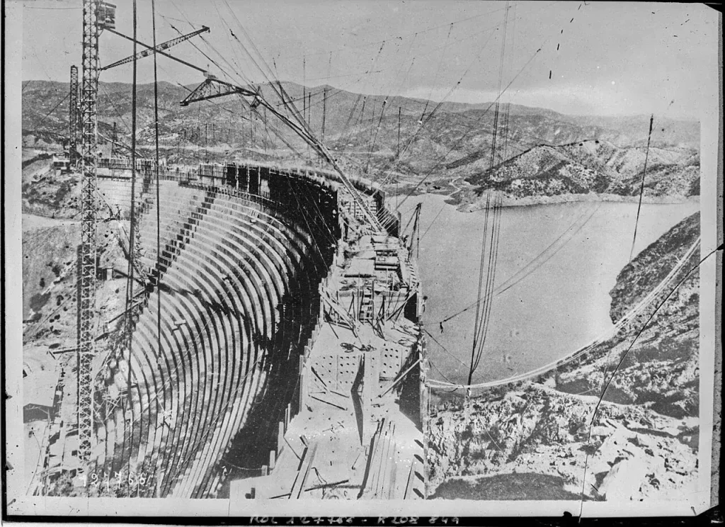
Then came the winter of 1927 to 1928. Rain filled the aqueduct system, and on March 7, 1928 the reservoir stood within three inches of the spillway crest for the first time, so close that wind-driven waves were slopping over the panels. Mulholland ordered that no more water be turned in. Every city reservoir was full by Sunday the eleventh. For the first time, the full depth of the lake was pressing on the foundation and on the fractured schist beside it, and for the first time the water had weeks in which to work its way in. The Geo-Institute’s account of the failure puts it in the language of Darcy’s law, the rule that seepage through rock rises with the pressure driving it: as the reservoir sat full, permeation through the fissile schist beneath the east abutment and the dam itself increased, and locals began noticing.
The slide was moving before anyone understood what they were seeing. Around 8:30 that Monday evening a family named Silvey drove up the canyon road past the dam and, about 100 feet beyond the east abutment, were stopped by a fresh scarp a foot high cutting across the roadway in the schist. Rogers reads that scarp as the entire east abutment having already dropped twelve inches, at least three and a half hours before the dam broke. A Stevens stage recorder mounted on the crest told a similar story. Its trace shows the reservoir beginning to fall slightly around eight o’clock, then dropping sharply near midnight. A drop of about 3.67 inches recorded 40 minutes before the failure is, in Rogers’s analysis, what the gauge would register if the dam had tilted forward by half a degree.
Hydraulic uplift dam failure, explained
Hydraulic uplift is water getting under a dam and pushing up on its base, the way water gets under a car’s tires and floats them during a hydroplane. A gravity dam is only as stable as its weight, and weight is exactly what uplift steals. If pressurized water reaches the foundation, it presses upward across the whole footprint, cancelling part of the downward force of the concrete. A dam that “weighs” less resists less horizontal push and generates less friction against sliding. Rogers puts it plainly: once the reservoir fills, water pressure inside the foundation rock pushes up on the dam and cancels part of its weight. A conventional stability check of the St. Francis section with full uplift included, he found, shows the dam becoming unstable in overturning once the reservoir rose to within seven feet of the crest. In March 1928 it was within three inches.
None of this was secret in the 1920s. Concern about uplift had been building since the 1880s and sharpened after September 30, 1911, when the Bayless dam at Austin, Pennsylvania, a concrete gravity structure, slid off its foundation and killed 78 people. One prominent American engineer declared afterward that designing a dam without considering upward pressure was a crime, and a paper on the subject appeared in the Transactions of the American Society of Civil Engineers the next year. The standard defenses were also established. Grout, a thin cement slurry, could be pumped into holes drilled along the dam’s heel to seal the cracks in the rock, lengthening the path water had to travel and cutting the seepage. A cutoff trench dug into the foundation and carried up both abutments could block seepage at the surface. Drainage wells drilled beneath the dam could bleed off whatever pressure got through. Charles Paul, who had built the 350-foot Arrowrock Dam in Idaho, laid all three out in Foundations, Abutments and Footings, a widely available 1923 McGraw-Hill handbook edited by Hool and Kinne and added that for a masonry dam over 200 feet, the only suitable foundation was “firm, hard rock, without open seams, fissures, or faulting.” He wanted a professional geologist’s report before design began and rock cores at least 20 feet deep, on top of the usual borings and test pits.
The St. Francis site got four or five borings, all along the west abutment and none deeper than 16 feet, plus the blasted tunnel in the east abutment. There were no test pits and no rock cores. There was no foundation grouting program either. Carl Grunsky, one of the most respected civil engineers in California, visited the site in March 1925 and noted that there was no sign of trenching up the hillsides to give the abutments proper vertical faces. The one uplift defense the dam did have was a set of ten drainage wells, two inches in diameter, in two rows beneath the central 120 feet of a structure about 660 feet long. That left roughly 270 feet of dam on each side, the whole of both sloping abutments, with no relief at all. It happens that the central 120 feet with the wells is the section that survived. The abutments without them are the sections that failed.
Part of the explanation is that the profession had not yet caught up with its own warnings. Until Karl Terzaghi showed in 1945 that water pressure could infiltrate mass concrete itself, most engineers assumed a concrete dam on hard rock stayed dry inside, and the textbooks the Bureau copied from summed up the forces on a gravity dam as if it did. The 1959 failure of the Malpasset arch dam in France, which killed more than 400 people when a rock wedge beneath its left abutment lifted, showed how easily uplift on a steep abutment could be underestimated even by the world’s leading arch-dam designer. Whether Mulholland met the standard of his own day is a question historians still argue, and it gets its own section below. What is beyond argument is that the physics was already in print.
The Block 35 “nozzle” and the failure sequence
Investigators numbered the surviving fragments of the dam, and the modern reconstruction turns on a piece called Block 35. It came from the very bottom of the east abutment, part of a stretch that the 1928 surveys could not find at all and labeled the “missing section.” Block 35 was identified months later by the schist stuck to its underside and the angle of its concrete pour lines, and one of the two candidates for it lay farther downstream than any other identified piece of the dam. In the reading developed by Rogers and summarized by the Geo-Institute, the last hour ran roughly like this.
Through the evening, rising pore pressure in the schist and rising uplift beneath the sloping east abutment had pushed the dam’s margins to the edge. By about 11:55 p.m. a piece of the dam at the base of the east abutment, Block 35, broke away. Reservoir water blasted out through the gap under nearly 200 feet of head, and the opening acted like a nozzle, a high-pressure jet fired straight into the foot of a hillside that was already saturated and already creeping. Rogers modeled this orifice flow and found that it alone could destabilize the slope. The reactivated paleo-landslide broke loose, and at 11:57:30 the entire east abutment let go, some 700,000 cubic yards of schist removed within minutes and taking the Lancaster power line with it, which is how the moment was frozen on the electrical record. The landslide threw a displacement wave across the reservoir that washed flotsam four feet above the high-water line three-quarters of a mile to the north.
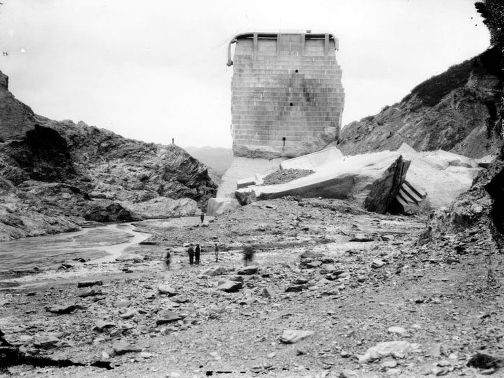
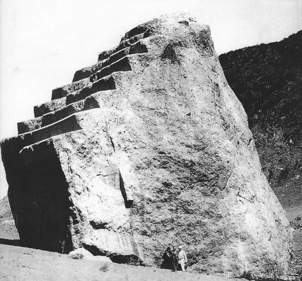
With its eastern anchor gone, the rest of the dam had nothing to arch against. The whole left abutment section of the dam was carried across the downstream face of the main structure by the slide, and the heavy blocks sheared ten to twenty feet of concrete off the stepped face as they went. Block 5, one of the largest, rode the landslide debris right across the canyon to the west abutment and then fell about 35 feet; patches of schist were still lying on its steps when investigators arrived. The center section, undercut on its left side, tilted and rotated. Benchmarks set in the crest showed after the failure that the surviving monolith had swung clockwise, its southern edge shifting 8.4 inches toward the southwest. Water entered a shrinkage crack on the west side of the center block, and only then, after the reservoir had already fallen by about 40 feet in Rogers’s 1995 reconstruction, and by 70 to 80 feet in his 2013 account, did the west abutment go. The lower water when it broke is why the west side of the canyon shows so much less erosion than the east. Toward the end, the left half of the main dam, undercut by 35 to 45 feet of scour beneath it, toppled backward at an angle of 54 degrees into the hole the flood had dug. By about 1:09 a.m. the reservoir was essentially empty.
Power House No. 2, 7,300 feet downstream, went off line at 12:02:30, exactly five minutes after the power line failed. That interval, plus the high-water marks measured afterward, let Rogers reconstruct a flood hydrograph. He puts the peak discharge at the dam site near 1.7 million cubic feet per second, and about 1.3 million at the power house, where the flood was still around 110 feet deep. For comparison, the largest flood ever measured on the Mississippi River at St. Louis peaked at a little over a million cubic feet per second.
The west abutment and the friable Sespe Formation
The west, or right, side of the canyon was different rock: a reddish sandstone-and-conglomerate unit laced with veins of gypsum. Conglomerate is cemented gravel, and this conglomerate had a fatal habit. When it got wet, its cement softened and the rock slaked, swelling and crumbling toward mud. The 1928 investigators called it the Sespe Formation, and the name has stuck to the story; later geologic mapping assigns these red beds to the Vasquez Formation, as Rogers points out, but the behavior is the same under either label. During the coroner’s inquest, the district attorney showed the jury how a lump of the red rock fell apart in water. The contact between the gray schist on the east and the red beds on the west runs along an old, inactive strand of the San Francisquito fault that crosses the canyon floor almost exactly where the dam was built.
The west abutment was also barely excavated. On the east side the Bureau’s crews had cut between 6 and 15 feet into the schist to seat the dam; on the west the excavation averaged about 4 feet, and construction photographs show concrete going in against loose talus that had never been cleaned off. This was the side the damkeeper was worried about on the morning of March 12, because it was where the leaks were most visible, and it was the side the Governor’s Commission blamed. Both abutments, in other words, were bad in their own way: a slippery, sliding schist on the east and a softening, swelling conglomerate on the west, meeting along a fault under a dam that had neither a cutoff trench nor a grout curtain, and no drainage beyond its middle.
Who was William Mulholland?
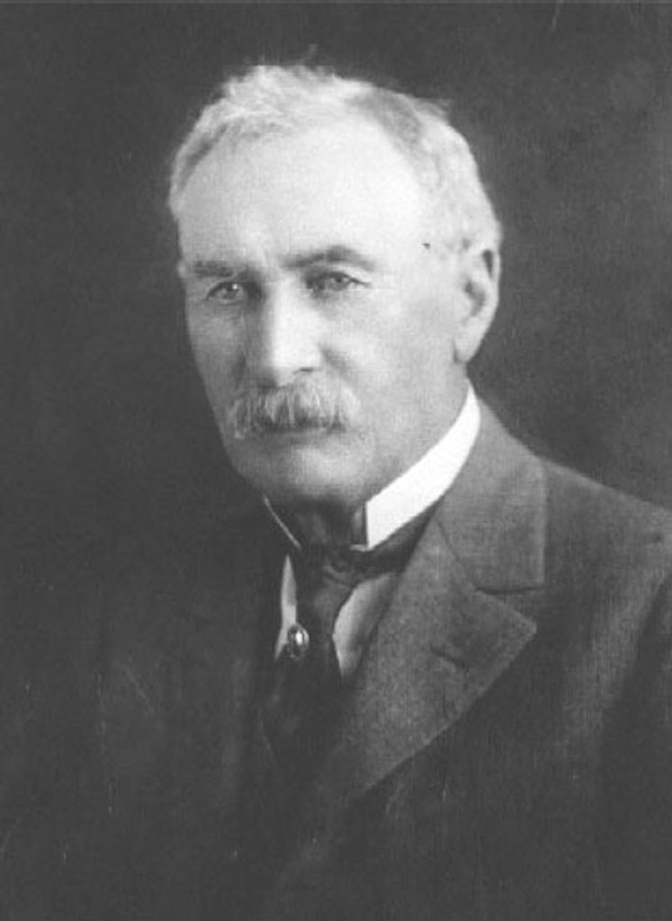
William Mulholland was born in Belfast on September 11, 1855, went to sea as a teenager, and reached Los Angeles in 1877 with almost nothing. In 1878 he took a job as a zanjero, a ditch tender, for the private company that ran the city’s water, and taught himself mathematics and hydraulics, and later geology, from borrowed textbooks after his shifts. He rose quickly. By 1886 he was superintendent of the company, and when the city bought the water system in 1902 he became head of the municipal department that grew into the Bureau of Water Works and Supply. His monument was the Los Angeles Aqueduct, 233 miles long, the longest in the world when it opened in 1913, delivered on schedule and under budget with a workforce of thousands and a design worked out largely in his own head. For a generation he was the most trusted public servant in Southern California. Mulholland Drive and Mulholland Dam both carry his name.
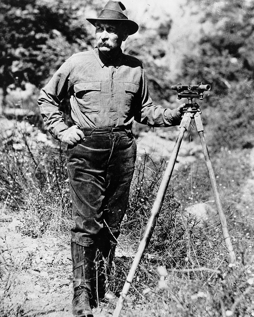
That record explains what followed. Mulholland had been right, publicly and spectacularly, for thirty years, and the city had rewarded him with a freedom no engineer would be given today. California had passed a dam safety law in 1917 that gave the state engineer authority to review dams, but it exempted dams built by municipalities with their own engineering departments, so no outside authority ever reviewed the St. Francis design. He did not commission a geologic study. He and John Casper Branner, a Stanford geology professor and mentor of Herbert Hoover, visited the canyon briefly before design began; apart from Carl Grunsky’s walk-through during construction, that was the extent of outside scrutiny. His experience was overwhelmingly with earthen embankment dams; St. Francis was only the second concrete dam his organization had ever built, and with its Hollywood twin it stood far taller than any of the earth dams that had come before. He was thrifty to the point of stinginess, which had let the city build its water system ahead of its growth at rock-bottom cost, and which, at St. Francis, meant no consultants and no instruments in the dam to tell anyone how it was behaving. The same trust meant that nobody checked his work.
The morning leak and the last inspection
The damkeeper, Tony Harnischfeger, lived in a cottage about a quarter mile below the dam with his six-year-old son Coder and a woman named Leona Johnson. He had watched cracks and leaks come and go as the reservoir rose, and he had learned which were ordinary. Water had seeped from both abutments for two years, enough that a two-inch pipe had been fitted to a leak on the west side to carry the flow down to his cottage for household use. Canyon residents traded rumors about the dam whenever they met, and one man later testified that he had told friends working at a nearby rock quarry that the leak looked to be getting pretty bad.
On the morning of March 12, Harnischfeger found something he did not like. A new leak had opened near the west abutment, and the water was muddy. Clear seepage is a nuisance; muddy seepage can mean the water is carrying away the material under the dam, hollowing out the foundation from below, a process engineers call piping. He telephoned Mulholland in Los Angeles. Mulholland and Van Norman made the two-hour drive and arrived at about 10:30. They walked the dam with the keeper for something between an hour and a half and two hours. The two men traced the muddy flow and concluded that the mud came from the loose soil of a freshly cut access road that the seepage was washing across, and that the water itself ran clear where it left the rock. They estimated the leak at two to three cubic feet per second. They also looked at the many small leaks along the east abutment that had caught the keeper’s eye. Mulholland thought some remedial work might eventually be worthwhile, but nothing urgent. He had said of this dam, in the highest praise he knew, that it was “the driest dam of its size I ever saw.” The two men pronounced it safe and drove back to the city around noon.
There was almost nothing else they could have done that day even if they had feared the worst. Rogers calculated that if all five outlet pipes had been opened at noon, the reservoir would have dropped only 1.67 feet by midnight. A lake of 38,000 acre-feet cannot be emptied in an afternoon through five 30-inch pipes. The only intervention that could have saved anyone would have been a warning to the canyon and the valley below, and no one that morning believed a warning was needed.
Harnischfeger did not survive the night. Passers-by saw a light in the canyon below the dam in the 45 minutes before the failure, and Leona Johnson’s body was found fully clothed, wedged between two blocks of concrete near the base of the dam, a quarter mile upstream of the cottage, which suggests the two of them were up at the structure looking at something in its final minutes. What they saw is unknowable. The keeper’s own body was never found.
The 54-mile night: Power House No. 2 to the sea
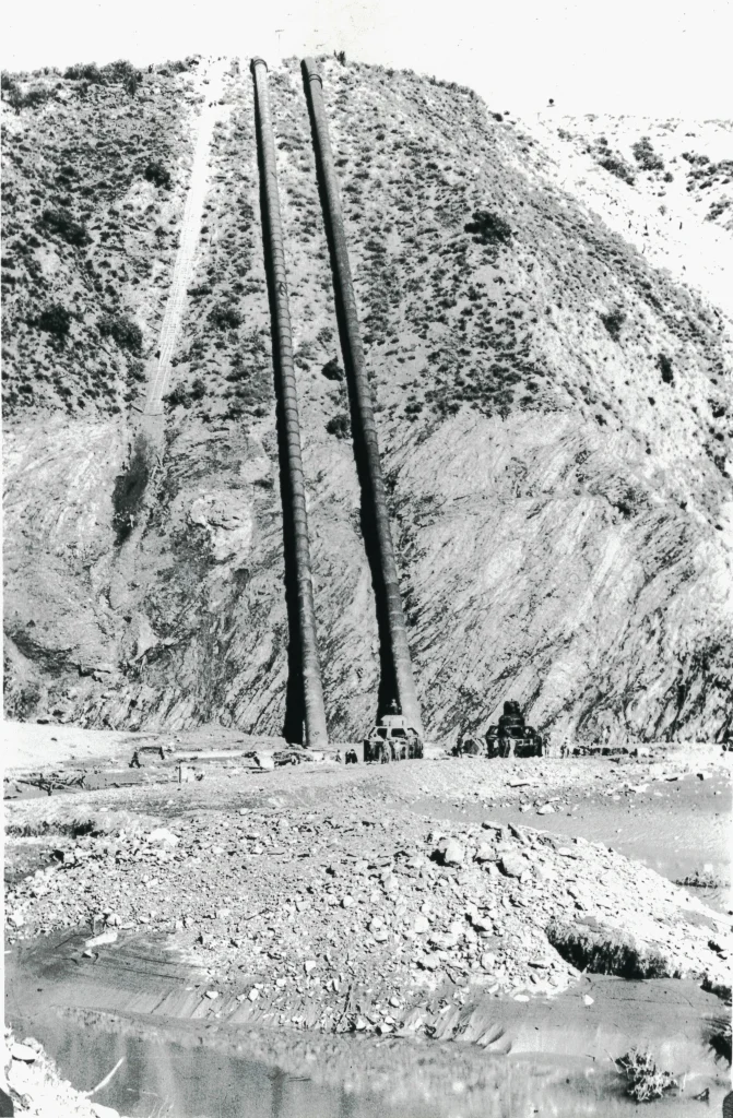
The wave that came out of the broken dam was about 140 feet high where it filled the canyon just below the site. A mile downstream it spilled over a natural saddle 120 feet above the creek. It moved through the upper canyon at an average of about 26 feet per second, roughly 18 miles per hour, faster than anyone could run and faster than most people could have driven that road in the dark. Five minutes after the power line went down, it reached Power House No. 2, 7,300 feet below the dam, still around 110 feet deep.
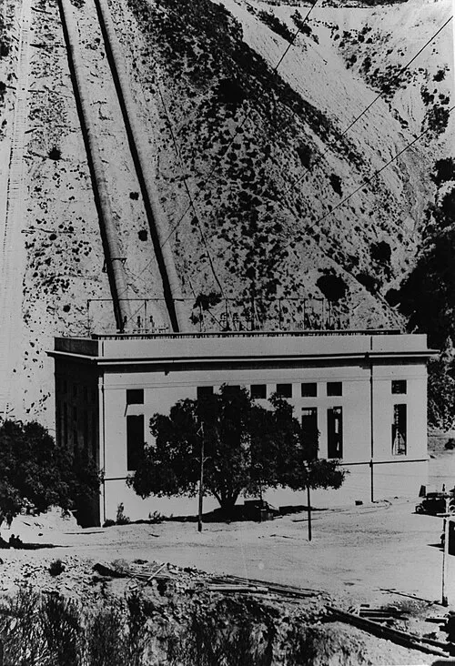
Sixty-seven people lived around the plant: operators, linemen, laborers, and their families, housed in a cluster of Bureau cottages beside the building. Sixty-four of them died. The flood took the power house down to its floor slab and left the generators standing in the open. Lillian Curtis woke to the roar and got out of her house with her three-year-old son, Danny, and scrambled up the hillside; her husband Lyman went back for their daughters, Marjorie and Mazie, and none of the three was seen alive again. Ray Rising, a utility man at the plant, was swept into the water and managed to climb onto a floating roof that carried him to safety. Those three were the only survivors from the power house community. High above the plant, the surge-chamber attendant, E.H. Thomas, felt what he took for an earthquake, watched the lights dim and die, and climbed down the tramway to the water’s edge. By 12:15 the flood had already fallen 20 feet from its crest. Power House No. 1, upstream, sent a man down the canyon in the dark; he came back to report that the dam was gone and the reservoir empty.
Below the canyon mouth the water spread over the ranch of the movie cowboy Harry Carey, wrecking part of it and carrying off the Navajo trading post that had been a tourist stop on the road. It spilled into the bed of the Santa Clara River and turned west. At the Edison substation in Saugus an assistant patrolman named Raymond Starbard was nearly washed away; he got a ride to a garage beside the Saugus Cafe and telephoned the sheriff’s substation in Newhall, which made him, by most accounts, the first person to raise an alarm. The wall of water, still about 75 feet high, rolled over Castaic Junction, swept the settlement away, and took out the highway bridge across the river. It ran on through the Camulos Ranch, ripping orange trees out by the roots.
The Edison camp at Kemp
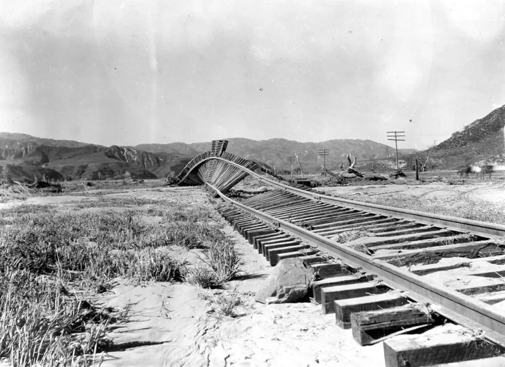
Just over the Ventura County line, at a railroad siding called Kemp beside a rock outcrop known as Blue Cut, Southern California Edison had pitched a tent camp for about 150 men building a transmission line. They were asleep. The night watchman, Ed Locke, heard the rumble coming down the valley and could not make sense of it until it was almost on the camp. He ran through the tents shouting, trying to wake as many men as he could, and died doing it. The wave struck the hills west of the camp and rebounded, setting up a whirlpool that tore the tents loose and spun them. Eighty-four of the men drowned. Some of those who lived owed it to a habit: their tents had been buttoned tight against the March cold, and a buttoned tent trapped enough air to float. It was the single deadliest place in the whole disaster.
Santa Paula, Fillmore, and the telephone
The warnings that saved the most lives traveled by wire and by motorcycle. At 1:30 a.m. the night telephone operator in Santa Paula, Louise Gipe, took a call from the chief long-distance operator of the Pacific Telephone company: the St. Francis Dam had broken and a wall of water was coming down the valley. Gipe stayed at her switchboard and began ringing homes in the low ground near the river instead of leaving to save herself. One of her calls went to a California Highway Patrol officer, Thornton Edwards, who pulled on his clothes, kicked his motorcycle to life, and rode from door to door with his siren going, then up and down the streets of the danger zone, earning the nickname that followed him for the rest of his life: the Paul Revere of the St. Francis flood. Officer Stanley Baker rode with him. Farther up the valley a deputy sheriff, Eddie Hearne, drove east toward the flood with his siren wailing, warning ranches as he went, until the water stopped him at Fillmore.
The flood tore through the low parts of Piru and Fillmore, then the farming settlement of Bardsdale across the river, and took the valley’s bridges one by one. In Santa Paula, houses along the river floated off their foundations and sailed through the streets; one came to rest four blocks from where it had stood. Past Saticoy the wave was spreading out and slowing down, still two miles wide and moving at something like five miles per hour. At about 5:30 in the morning, five and a half hours and roughly 54 miles from the dam, it passed under the Montalvo bridge and reached the Pacific between Oxnard and Ventura, about 15 feet high and semi-solid with mud and wreckage, carrying bodies with it. Some of the dead were never recovered. Some washed ashore days and weeks later, a few reportedly as far south as the Mexican border.
St. Francis Dam death toll: why the number is uncertain
No one knows exactly how many people the flood killed, and the reasons are built into the disaster itself. Many victims were carried to sea and never found. Many were farm laborers, a large share of them Mexican and some Japanese and Filipino, living in section camps and riverbank settlements whose populations no one had counted; their relatives were sometimes far away and never filed claims. The recovery was scattered across three counties and a dozen improvised morgues. Newspapers ran daily lists of the identified dead for a few days and then folded new names into their main stories, so that even the press lost track. Bodies kept turning up for decades, into the 1950s, and the memorial foundation records one victim whose remains were found near Newhall as late as 1992.
The result is a spread of figures rather than a single number. The Claims Bureau of the Citizens’ Restoration Committee, which handled the city’s settlements, reported in August 1928 a total of 385: 224 identified dead, 60 unidentified, and 101 missing. The Ventura County coroner, Oliver Reardon, kept meticulous records that pointed higher, 319 bodies recovered and 101 missing, about 420. Outland concluded that any figure over 450 or under 400 was unrealistic. Britannica puts the official toll at about 450 and says the real number was probably higher. The archaeologist Ann Stansell, whose master’s thesis produced the most careful modern roster and whose list is being refined for the memorial wall, put the count between 308 bodies recovered (240 identified, 68 not) and a maximum of 403 including 95 missing in the list on the memorial foundation’s site, and 431 in her updated 2018 roster, the figure cited in Congress when the national memorial was created. Some researchers argue that undocumented workers push the true number past 600, and UCLA’s catalog of the Los Angeles Times photographs of the disaster uses that figure. The phrase to hold on to is the one the U.S. Geological Survey uses: at least 431. It is a floor, and the true number is higher.
The 1928 inquest and “fasten it on me”
Within a week, four inquiries were under way, and eventually as many as eight agencies, federal, state, county, and city, were asking the same question. Governor C. C. Young appointed a six-man commission chaired by the dam engineer A. J. Wiley, with two geology professors, George Louderback of Berkeley and Frederick Ransome of Caltech, among its members. The commission met on March 19, visited the site once, on March 20, and issued its report five days later. The Los Angeles City Council convened its own board under Elwood Mead, the federal reclamation commissioner. Engineering News-Record sent its Pacific Coast editor, Nathan Bowers, who studied the wreckage, interviewed the Bureau’s engineers, and wired a 2,400-word dispatch to New York within 36 hours; his dispatch described how “a single piece remained standing, while the rest slumped to the valley floor or was swept out.” The most searching inquiry, and the only one that took sworn testimony on more than geology, was the two-week Los Angeles County coroner’s inquest, convened by Coroner Frank Nance and driven by District Attorney Asa Keyes.
Keyes wanted a culprit, and he had Mulholland on the stand for days. He pressed him on the mix of the concrete, on the choice of a site astride a fault, on the drainage of the foundation and the anchoring of the dam to the canyon walls, and on his unchecked personal command of the whole project. He accused him of brushing off leaks in the days before the failure. Mulholland, for his part, floated the theory that Owens Valley saboteurs had dynamited the dam, and when Keyes asked whether he would build on the same spot again, he answered that he would not, because it had failed, and because, in his words, “There is a hoodoo on it.” Rogers later dealt with the dynamite theory directly: the thousands of dead fish found in the plunge pools below the dam had died of silt in their gills, evidence of a very muddy outflow, and wartime tests suggest it would have taken more than 12,000 pounds of explosive under 30 feet of water to breach the structure.
Then Mulholland did something rare for a man of his standing. He took the blame. He told the jury that the inquest was painful to attend and that he envied only the dead. Toward the end of his testimony he asked the jurors not to blame anyone else, “you just fasten it on me,” and added that if there had been “an error in human judgment,” “I was the human.” The words were reported across the country. The Los Angeles Times of March 28 ran them under the headline that the foundation was blamed and that Mulholland took the blame for mistakes.
The jury split the difference. It found that the dam had been destroyed by the failure of the rock formations it was built on, and that no defect in the design or materials of the dam itself was to blame. It found no criminal act, since no one at the time could have known the rock was unstable. It also placed responsibility squarely on Mulholland and the Bureau, and it delivered a rebuke that made national headlines and that Rogers still quotes with approval: the construction and operation of a great dam “should never be left to the sole judgment of one man, no matter how eminent,” without checking by independent experts. The City of Los Angeles accepted liability without a fight and paid out, by its own accounting, $9,392,487.57 in reconstruction and settled claims. Mulholland retired late in 1928, and Van Norman succeeded him. He spent his last years in near seclusion and died in Los Angeles on July 22, 1935, at 79, never knowing what had actually happened under his dam.
Was the St. Francis Dam disaster preventable?
The question will not settle, and it splits into two claims that have to be kept apart. The first: could anyone in 1928 have detected the fossil landslide in the east abutment? Rogers is generous to Mulholland here. The paleo-landslide would have been hard for almost any geologist of the 1920s to recognize, and the site had been looked at by respected experts. In Rogers’s reading, Mulholland and his engineers belonged to a profession that “did not completely appreciate or understand the concepts of effective stress and uplift,” ideas that were only beginning to gain acceptance. The failure, on this view, belongs less to one man than to the state of an entire discipline, and Rogers credits Mulholland with the character to shoulder responsibility for shortcomings that very few people then fully understood.
The second claim is narrower and harder on Mulholland: setting aside the hidden landslide, did the dam meet the ordinary standard of care of its own day? The historians Donald C. Jackson and Norris Hundley Jr., in a 2004 article in California History and their 2015 book Heavy Ground, answer no. They point out that the dangers of uplift were well publicized after the 1911 Austin failure, that at least three technical books of the 1910s explained how to guard against it, and that several curved gravity dams built across the country before St. Francis had used extensive grouting, full-length drainage, and deep cutoff trenches. By the early 1920s, they argue, drainage wells confined to the center section of a big concrete gravity dam were no longer standard practice in California. The engineer Michael Bennett, writing for the Geo-Institute in 2025, tested the same question against Charles Paul’s 1923 handbook and reached the same verdict: on geologic study, on subsurface investigation, on grouting, on cutoff trenches, and on drainage, the St. Francis design fell well short of what a widely available reference of its time called for. Jackson and Hundley’s conclusion is unsparing. Whatever his equivocations and his talk of hoodoos, Mulholland understood the privilege he had been given to build where and how he chose, and because of that privilege and his decisions, “William Mulholland bears responsibility for the St. Francis Dam disaster.”
Both claims can be true at once. The specific killer, the reactivated landslide in the schist, was probably beyond detection in 1928. The dam was also under-defended against hazards its own era already understood, and a competent outside review in 1923 or 1924 would very likely have demanded borings, a geologist’s report, a grout curtain, and abutment drainage, any of which might have changed the design, the site, or the decision to build at all. The Geo-Institute’s summary of the modern consensus is blunt: there is broad agreement on how the dam failed, and far less on whether Mulholland’s design met the standard of his day.
How the disaster rewrote the rules
The failure rewrote California’s law. On August 14, 1929 the California legislature enacted a dam safety statute that removed the exemption municipal dams had enjoyed under the 1917 law and placed essentially every non-federal dam in the state, above 25 feet in height or 50 acre-feet of storage, under the review and supervision of the state engineer. That authority became today’s Division of Safety of Dams, which still reviews the design and construction of well over a thousand dams. The same session created the state’s Board of Registration for Civil Engineers, the ancestor of the present Board for Professional Engineers, Land Surveyors, and Geologists, so that anyone designing a dam in California would have to hold a license and answer to a board. The requirement that dams be built under a licensed engineer’s supervision dates from that year.
The failure also helped bring a new discipline into being. Engineering geology, the practice of putting a trained geologist on a construction site before the design is fixed, existed in outline before 1928, but St. Francis became its founding case study, the example every textbook reaches for to show what happens when a dam is placed on ground no one has read. The lesson spread outward quickly. Boulder Dam, then before Congress as the Swing–Johnson bill, was nearly derailed by fears that if the City of Los Angeles could not build a 200-foot dam safely, no one could build a 700-foot one; the Geo-Institute notes that the Governor’s Commission’s praise for the surviving center section, which had in fact nearly failed, likely owed something to the need to protect that project. The Boulder Canyon Project Act passed anyway, in December 1928, with foundation investigation and independent review built into it. Closer to home, Mulholland Dam in Hollywood, the near twin, was reexamined, judged vulnerable to the same uplift, had its reservoir drawn down, and in 1933 and 1934 was buried under hundreds of thousands of cubic yards of earth fill against its downstream face. It stands today as a landscaped hill with a lake behind it, and most of the people who walk around Hollywood Reservoir do not know it is a dam.
The St. Francis Dam ruins today
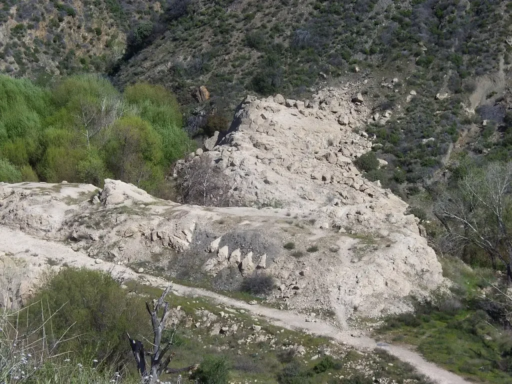
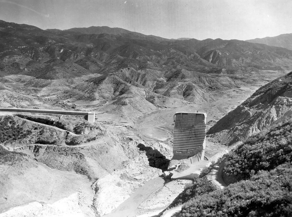
The Tombstone did not last long. It drew sightseers and souvenir hunters by the thousand, and in 1929, after a young man fell to his death from the top of it, the Bureau dynamited the center section and broke up the remaining blocks with bulldozers and jackhammers so that no one else would climb them. What survives now is weathered gray concrete scattered through the creek bed, stubs of rusted cable and steel, the buried line of the wing dike along the western ridge, and, for anyone who knows to look up, the scar of the ancient landslide on the east hillside, still visible as a raw bowl in the slope. Several of the largest blocks lie where the flood left them, some hundreds of yards downstream, half-buried in the alluvium they helped to move. The canyon road was rerouted away from the main site when it was rebuilt in 2009 after storm damage in 2005, and the ruins are reached on foot along the old alignment.
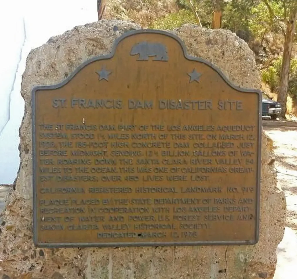
The site was registered as California Historical Landmark No. 919 on April 26, 1978, and its bronze marker stands beside the rebuilt Power House No. 2 on San Francisquito Canyon Road, about a mile and a half below where the dam stood. On March 12, 2019, the 91st anniversary of the failure, the John D. Dingell Jr. Conservation, Management, and Recreation Act established the Saint Francis Dam Disaster National Monument and authorized a national memorial to the victims, both within the Angeles National Forest and managed by the U.S. Forest Service. The St. Francis Dam National Memorial Foundation, a nonprofit led by local historians, is raising money to help the Forest Service build a visitor center and a memorial wall carrying the names of every known victim, and the Forest Service has since run a design competition for the memorial and announced its winners.
The open questions: the 1928 commission versus the Rogers reinterpretation
The central scientific disagreement is about which abutment failed first. It has never been fully resolved, and both positions deserve to be stated in full.
The 1928 view came from the Governor’s Commission and was shared, in outline, by most of the other official inquiries and by the coroner’s jury. In this reading the failure began on the west, or right, side of the canyon, in the red conglomerate. Water percolating along the fault and into that weak rock softened the west abutment until it could no longer carry the dam; the collapse there released a torrent that scoured the east wall of the canyon and brought down the rest. The commission judged the entire foundation unfit and the outcome all but fated, writing that “the ultimate failure of this dam was inevitable” unless water could have been kept away from the foundation. Its strongest physical argument was the position of the debris. A plane-table survey by a state highway surveyor, Horace Wildy, mapped eleven of the twenty large fragments, and the block that had traveled farthest downstream, Block 16, came from the west end. To the commission that meant the west end went first and was flung the greatest distance. The coroner’s jury, while admitting ambivalence about the initiating event, also thought the preponderance of evidence pointed to the western abutment, and the sight of red conglomerate falling apart in water in the courtroom made the argument vivid.
The minority view of 1928, and the modern reinterpretation that grew from it, holds that the east abutment went first. Bailey Willis, working with the civil engineers Carl and E. L. Grunsky, identified the ancient landslide in the schist; the Grunskys described the dam as caught between uplift beneath it and swelling conglomerate beside it. Carl Grunsky also found the crushed wooden ladder of the stage recorder wedged in a tension crack at the dam’s upstream heel, evidence that the heel had been pulled open, which is what happens to a gravity dam that is tipping forward. Outland carried the east-first reading into his 1963 book. Rogers built it into the detailed sequence described earlier, and he answered the commission’s debris argument on its own terms. The 1928 survey recorded positions but not elevations. Blocks 12 and 14, from the base of the east abutment, lay 26 feet higher than Block 16 and well off to the side of the channel, and Block 11 may have formed a temporary dam with Blocks 12 and 13 that deflected later flow toward the spot where Block 16 came to rest. And the city engineers Ralph Proctor, H. C. Gardett, and A. R. Arledge, who surveyed the aftermath in detail, later identified the source of seventeen blocks and found that the one carried farthest of all, Block 35, came from the bottom of the east abutment. Rogers also explains how blocks of 10,000 tons traveled half a mile: the flood was so loaded with pulverized schist that the effective weight of concrete in it dropped to a fraction of its dry weight, and the blocks were rolled along like pebbles.
The modern consensus leans toward the east-abutment reading, with uplift on an under-drained, under-widened base and a reactivated paleo-landslide as the initiating mechanism, and it is the version most engineering-geology courses now teach. It is still a reinterpretation, made decades after the fact, of a structure that was demolished in 1929, and it rests on a reconstruction of evidence that the original investigators saw fresh and read differently. The 1928 commissions had the advantage of standing in the wreckage a week after the flood. The modern analysts have the advantage of theory the 1928 engineers lacked. The disagreement over the initiating abutment, like the disagreement over the exact death toll and over how much Mulholland could have foreseen, is part of the record of this disaster, and it belongs in the record.
Frequently asked questions
What caused the St. Francis Dam to fail?
The dam was built on defective rock on both sides of the canyon, and filling the reservoir to the brim for the first time turned that rock against it. In the modern reading, water pressure inside the fractured Pelona Schist of the east abutment revived an ancient landslide and lifted the dam’s under-widened, under-drained base through hydraulic uplift, until a block at the foot of the east abutment broke away and the whole east side collapsed. The 1928 Governor’s Commission instead blamed the west abutment’s red conglomerate, which softened when wet. Either way, the foundation was never suitable for a 205-foot dam.
How many people died in the St. Francis Dam disaster?
At least 431, the figure used by the U.S. Geological Survey and by Congress when it created the national memorial. The official count in August 1928 was 385, the Ventura County coroner’s records suggested about 420, the historian Charles Outland put the true figure between 400 and 450, and some researchers argue that uncounted migrant workers push it past 600. Bodies were still being found decades later, so an exact number will never be known.
Who was William Mulholland?
A self-taught civil engineer, born in Belfast in 1855, who rose from ditch tender to chief engineer of the Los Angeles water system and built the 233-mile Los Angeles Aqueduct, completed in 1913, that allowed the city to grow into a metropolis. He designed and oversaw the St. Francis Dam without outside review. Its failure ended his career; he took public responsibility at the coroner’s inquest, retired at the end of 1928, and died in 1935.
What is Pelona Schist, and why did it matter?
Pelona Schist is a metamorphic rock, once sea-floor sand and mud, whose flaky mica minerals were pressed into parallel sheets deep underground, so that it splits and slides along those sheets like a wet deck of cards. The east abutment of the dam was anchored to this rock, and the hillside there was an ancient landslide within it. When the full reservoir saturated the schist, the old slide lost its grip and moved, taking the east end of the dam with it.
What is hydraulic uplift in a dam failure?
It is pressurized water working its way beneath a dam and pushing upward on its base, cancelling part of the dam’s weight, the way water under a tire lifts a car during a hydroplane. A gravity dam depends on its weight for stability, so uplift makes it easier to slide or tip. The St. Francis Dam had drainage wells to relieve uplift under only its central 120 feet, leaving both abutments unprotected, and those abutments were the parts that failed.
Was the St. Francis Dam disaster preventable?
Partly. The specific trigger, the hidden landslide in the schist, would have been hard for 1920s geologists to detect, which is the reading J. David Rogers favors. The historians Donald Jackson and Norris Hundley argue that the dam nonetheless fell short of the standard of care of its own day on uplift protection, grouting, cutoff trenches, and independent review, so a proper outside investigation would likely have forced a safer design or a different site.
Where was the St. Francis Dam, and can you visit the site?
It stood in San Francisquito Canyon in the Sierra Pelona Mountains, about ten miles north of Santa Clarita and roughly forty miles from downtown Los Angeles. The ruins are now within the Saint Francis Dam Disaster National Monument in the Angeles National Forest, managed by the U.S. Forest Service, and can be reached on foot along the old San Francisquito Canyon Road. The historical landmark marker stands beside Power House No. 2, about a mile and a half below the dam site.
Did the disaster change how dams are built?
Yes. In 1929 California removed the exemption that had kept municipal dams outside state review, placed almost all dams in the state under the supervision of the state engineer, and created a licensing board for civil engineers. The failure became the founding case study of engineering geology and reshaped how foundations are investigated, grouted, and drained.
Is the St. Francis Dam related to Mulholland Dam and Hollywood Reservoir?
Mulholland Dam, finished in 1924 in the hills above Hollywood, was the St. Francis Dam’s near twin and the model for its design. After the disaster it was judged vulnerable to the same uplift, its reservoir was drawn down, and in 1933 and 1934 its downstream face was buried under a massive earth fill. Hollywood Reservoir still sits behind it.




_to_Van_Norman_Reservoir_Complex_(San_Fernando_Valley),_Los_Angeles,_Los_Angeles_County,_CA_HAER_CA-298_(sheet_14_of_18).png)


_-_btv1b53197516p.jpg)


.jpg)


