Opens in a new tab
Geoscopy
Geology, explained.
Generic selectors
Exact matches only
Search in title
Search in content
Post Type Selectors

Rocks

An atlas of rocks and minerals: each one a record of the conditions that made it.

Glossary

Filter - Radio

Sort by

L

Lithosphere Mantle

The lithosphere mantle is the portion of the Earth's mantle that lies.. more →
L

Lithosphere-Asthenosphere Boundary (LAB)

The Lithosphere-Asthenosphere Boundary (LAB) is the depth at which the Earth's rigid.. more →
L

Lithospheric Flexure

Lithospheric flexure refers to the bending of the Earth's lithosphere under the.. more →
L

Lithospheric Plates

Lithospheric plates are large, rigid sections of the Earth's lithosphere that move.. more →
L

Littoral Zone

The littoral zone is the part of a sea, lake, or river.. more →
M

Mafic Dike

A mafic dike is a sheet-like intrusion of mafic magma that cuts.. more →
M

Mafic Intrusion

A mafic intrusion is an igneous body composed predominantly of mafic minerals,.. more →
M

Mafic Lava

Mafic lava is a type of lava that is rich in magnesium.. more →
M

Mafic Magma

Mafic magma is a type of magma that is rich in magnesium.. more →
M

Magma

Magma is molten or semi-molten rock located beneath the Earth's surface. It.. more →
M

Magmatic Differentiation

Magmatic differentiation is the process by which a single magma evolves into.. more →
M

Magnetic Anomaly

A magnetic anomaly is a variation in the Earth's magnetic field resulting.. more →
M

Magnetic Reversal

A magnetic reversal occurs when the Earth's magnetic field flips, with the.. more →
M

Magnetic Susceptibility

Magnetic susceptibility is a measure of how much a material will become.. more →
M

Magnetostratigraphy

Magnetostratigraphy is a geochronological technique that uses the magnetic properties of rock.. more →
M

Manganese Crusts

Manganese crusts are hard, layered deposits rich in manganese, iron, and other.. more →
M

Manganese Nodules

Manganese nodules are small, rounded concretions of manganese and other metals, such.. more →
M

Mantle Convection

Mantle convection is the slow, churning movement of the Earth's mantle caused.. more →
M

Mantle Plume

A mantle plume is a column of hot, solid material that rises.. more →
M

Mantle Transition Zone

The mantle transition zone is the region of the Earth's mantle located.. more →
M

Mantle Xenolith 

A mantle xenolith is a fragment of the Earth's mantle that is.. more →
M

Marine Isotope Stages (MIS)

Marine Isotope Stages (MIS) are alternating warm and cold periods in Earth's.. more →
M

Marine Regression

A marine regression occurs when sea level falls relative to the land,.. more →
M

Marine Sedimentation

Marine sedimentation refers to the deposition of sediments in marine environments, including.. more →

LLithosphere Mantle

The lithosphere mantle is the portion of the Earth’s mantle that lies beneath the lithosphere’s crust and is part of the rigid outer shell of the Earth. It plays a key role in plate tectonics, as the lithospheric plates are composed of both crust and lithospheric mantle. Understanding its composition and behavior is essential for studying mantle dynamics and plate movements. 

Reference: Anderson, D. L. (2007). “New Theory of the Earth.” Cambridge University Press. 
Share 

Open entry →
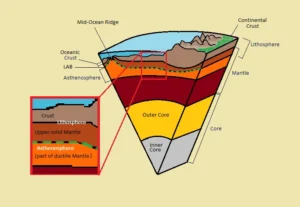
Earth layers diagram showing crust, mantle, and core (Lithosphere-Asthenosphere Boundary (LAB))

LLithosphere-Asthenosphere Boundary (LAB)

The Lithosphere-Asthenosphere Boundary (LAB) is the depth at which the Earth’s rigid lithosphere transitions into the more ductile asthenosphere. This boundary is critical in understanding plate tectonics, as it marks the zone where tectonic plates move over the more fluid asthenosphere, influencing the dynamics of plate movement. 

Reference: Schubert, G., Turcotte, D. L., & Olson, P. (2001). “Mantle Convection in the Earth and Planets.” Cambridge University Press.
Share 

Open entry →
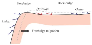
Diagram of forebulge and back-bulge migration (Lithospheric Flexure)

LLithospheric Flexure

Lithospheric flexure refers to the bending of the Earth’s lithosphere under the weight of an overlying load, such as a mountain range, ice sheet, or volcanic island. This process is important in understanding isostatic adjustments, the formation of foreland basins, and the structural response of the lithosphere to loading and unloading events. 

Reference: Watts, A. B. (2001). “Isostasy and Flexure of the Lithosphere.” Cambridge University Press. 
Share 

Open entry →

LLithospheric Plates

Lithospheric plates are large, rigid sections of the Earth’s lithosphere that move over the more ductile asthenosphere. The interaction of these plates at their boundaries results in significant geological phenomena, including earthquakes, volcanic activity, and mountain building. The study of lithospheric plates is fundamental to the theory of plate tectonics. 

Reference: Gordon, R. G. (1998). “The Plate Tectonic Approximation: Plate Nonrigidity, Diffuse Plate Boundaries, and Global Plate Reconstructions.” Annual Review of Earth and Planetary Sciences, 26(1), 615-642.

Share 

Open entry →
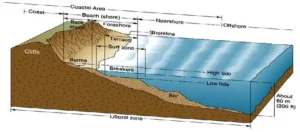
Diagram of coastal and beach zones with tide levels (littoral zone)

LLittoral Zone

The littoral zone is the part of a sea, lake, or river that is close to the shore and extends from the high-water mark to the area where sunlight penetrates to the sediment, allowing aquatic plants to grow. This zone is critical for studying coastal processes, ecosystems, and the impact of human activities on nearshore environments. 

Reference: Wetzel, R. G. (2001). “Limnology: Lake and River Ecosystems.” Academic Press. 

Share 

Open entry →
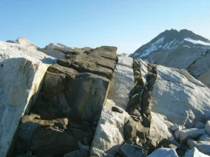
Dark basalt dike cutting through light granite rock (mafic dike)

MMafic Dike

A mafic dike is a sheet-like intrusion of mafic magma that cuts through existing rock layers. Dikes are important in understanding the processes of magma emplacement, the mechanics of crustal extension, and the formation of volcanic and plutonic rock bodies. 

Reference: Best, M. G. (2003). “Igneous and Metamorphic Petrology.” Wiley-Blackwell. 

Share 

Open entry →
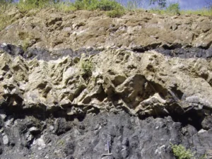
Exposed rock layers showing geological strata (mafic intrusion)

MMafic Intrusion

A mafic intrusion is an igneous body composed predominantly of mafic minerals, such as pyroxene and olivine, that has intruded into the Earth’s crust. These intrusions are significant for studying the processes of magma emplacement, the formation of ore deposits, and the thermal evolution of the crust. 

Reference: Best, M. G. (2003). “Igneous and Metamorphic Petrology.” Wiley-Blackwell. 

Share 

Open entry →

MMafic Lava

Mafic lava is a type of lava that is rich in magnesium and iron, typically forming basaltic rocks. It is relatively low in silica, which makes it less viscous and allows it to flow more easily than felsic lava. Mafic lava is significant in the formation of oceanic crust, volcanic islands, and large igneous provinces. 

Reference: Best, M. G. (2003). “Igneous and Metamorphic Petrology.” Wiley-Blackwell. 

Share 

Open entry →
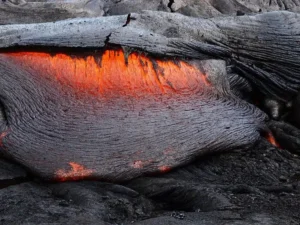
Hot molten lava cooling into dark rock (mafic magma)

MMafic Magma

Mafic magma is a type of magma that is rich in magnesium and iron and has a low silica content. It is typically less viscous than felsic magma and is associated with the formation of basaltic rocks. Mafic magma plays a significant role in the formation of oceanic crust and basaltic lava flows. 

Reference: Wilson, M. (1989). “Igneous Petrogenesis: A Global Tectonic Approach.” Unwin Hyman. 

Share 

Open entry →
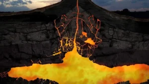
Cross-section of volcano showing flowing molten magma

MMagma

Magma is molten or semi-molten rock located beneath the Earth’s surface. It contains a mixture of liquids, gases, and crystals and can vary in composition from basaltic to rhyolitic. Magma plays a crucial role in the formation of igneous rocks through cooling and solidification and is a key component in volcanic activity. 

Reference: Carmichael, I. S. E., Turner, F. J., & Verhoogen, J. (1974). “Igneous Petrology.” McGraw-Hill.

Share 

Open entry →
Diagram showing the rock cycle process stages (Magmatic Differentiation)

MMagmatic Differentiation

Magmatic differentiation is the process by which a single magma evolves into multiple different types of igneous rocks through mechanisms such as fractional crystallization, assimilation, and magma mixing. This process is key to understanding the diversity of igneous rocks and the formation of complex volcanic and plutonic bodies. 

Reference: Winter, J. D. (2010). “Principles of Igneous and Metamorphic Petrology.” Pearson. 

Share 

Open entry →
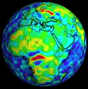
Colorful topographic map of Earth showing Africa and Europe (magnetic anomaly)

MMagnetic Anomaly

A magnetic anomaly is a variation in the Earth’s magnetic field resulting from the differing magnetic properties of subsurface rocks. These anomalies are used in geophysical exploration to detect buried structures, mineral deposits, and other geological features. Magnetic anomalies are crucial in the study of plate tectonics and the mapping of the ocean floor. 

Reference: Blakely, R. J. (1995). “Potential Theory in Gravity and Magnetic Applications.” Cambridge University Press. 
Share 

Open entry →
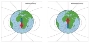
Earth magnetic field normal and reversed polarity diagram (magnetic reversal)

MMagnetic Reversal

A magnetic reversal occurs when the Earth’s magnetic field flips, with the magnetic north and south poles switching places. These reversals are recorded in rocks and are used to study the history of the Earth’s magnetic field, plate tectonics, and the geochronology of rock sequences. 

Reference: Cox, A. (1969). “Geomagnetic Reversals.” Science, 163(3873), 237-245. 

Share 

Open entry →

MMagnetic Susceptibility

Magnetic susceptibility is a measure of how much a material will become magnetized in an applied magnetic field. It is used in geology to study the magnetic properties of rocks, sediments, and soils, providing insights into the composition, provenance, and environmental history of geological materials. 

Reference: Dunlop, D. J., & Özdemir, Ö. (1997). “Rock Magnetism: Fundamentals and Frontiers.” Cambridge University Press. 
Share 

Open entry →
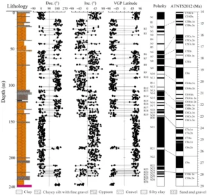
Geological core chart showing lithology and magnetic polarity data (Magnetostratigraphy)

MMagnetostratigraphy

Magnetostratigraphy is a geochronological technique that uses the magnetic properties of rock sequences to establish the age of the rocks. By comparing the recorded magnetic polarity in rock layers with the known geomagnetic polarity timescale, geologists can correlate and date sedimentary and volcanic sequences. 

Reference: Opdyke, N. D., & Channell, J. E. T. (1996). “Magnetic Stratigraphy.” Academic Press. 

Share 

Open entry →
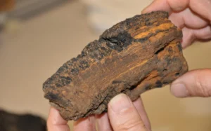
Hands holding a layered rock sample of manganese crusts

MManganese Crusts

Manganese crusts are hard, layered deposits rich in manganese, iron, and other metals that form on the ocean floor, particularly on seamounts and ridges. These crusts are significant for their potential as a resource for critical metals and for studying the geochemical processes of the ocean. 

Reference: Hein, J. R., Koschinsky, A., & Halbach, P. (2000). “Deep-Ocean Ferromanganese Crusts and Nodules.” In: Cronan, D. S. (Ed.), Handbook of Marine Mineral Deposits. CRC Press, pp. 239-279.

Share 

Open entry →
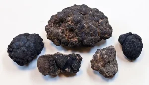
Five dark manganese nodules on white background

MManganese Nodules

Manganese nodules are small, rounded concretions of manganese and other metals, such as iron, copper, and nickel, found on the ocean floor. They form by the slow precipitation of metals from seawater and are significant as potential sources of rare metals and for studying oceanic geochemical processes. 

Reference: Glasby, G. P. (2006). “Manganese Nodules: A Review and Global Environmental Implications.” Oceanography and Marine Biology: An Annual Review, 44(1), 1-66. 

Share 

Open entry →
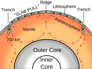
Diagram showing Earth's inner layers and mantle convection.

MMantle Convection

Mantle convection is the slow, churning movement of the Earth’s mantle caused by heat from the Earth’s core. This process drives plate tectonics, influencing the movement of lithospheric plates and the formation of geological features such as mountains, mid-ocean ridges, and volcanic arcs. 

Reference: Turcotte, D. L., & Schubert, G. (2002). “Geodynamics.” Cambridge University Press.
Share 

Open entry →
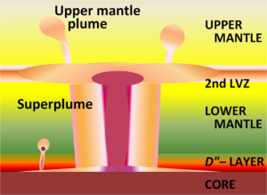
Earth mantle plumes and core structure diagram

MMantle Plume

A mantle plume is a column of hot, solid material that rises from deep within the Earth’s mantle and can lead to volcanic activity at the surface, often forming hot spots and large igneous provinces. Mantle plumes are significant in understanding the thermal dynamics of the mantle and the creation of volcanic islands like Hawaii. 

Reference: Courtillot, V., & Olson, P. (2007). “Mantle Plumes and Dynamics of the Earth’s Interior.” Nature, 385(6615), 37-42.

Share 

Open entry →
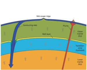
Diagram of Earth's mantle layers and tectonic processes (Mantle Transition Zone)

MMantle Transition Zone

The mantle transition zone is the region of the Earth’s mantle located between the upper and lower mantle, typically between 410 and 660 kilometers in depth. This zone is characterized by changes in mineral structure and composition, influencing mantle convection and the dynamics of plate tectonics. 

Reference: Ringwood, A. E. (1991). “Phase Transformations and Their Bearing on the Constitution and Dynamics of the Mantle.” Geochimica et Cosmochimica Acta, 55(8), 2083-2110. 

Share 

Open entry →
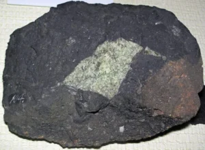
Dark meteorite rock with green mineral inclusion (mantle xenolith)

MMantle Xenolith 

A mantle xenolith is a fragment of the Earth’s mantle that is brought to the surface by volcanic activity, typically enclosed within an igneous rock. These xenoliths provide direct evidence of the composition, temperature, and pressure conditions in the mantle and are crucial for understanding mantle processes and Earth’s interior. 

Reference: Harte, B. (2010). “Mantle Peridotites and Processes—The Kimberlite Sample.” Journal of the Geological Society, 167(4), 639-646. 

Share 

Open entry →
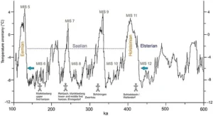
Climate temperature anomalies over 600,000 years chart (Marine Isotope Stages (MIS))

MMarine Isotope Stages (MIS)

Marine Isotope Stages (MIS) are alternating warm and cold periods in Earth’s paleoclimate, determined by oxygen isotope ratios in marine sediment cores. These stages are important for understanding past climate changes, glacial-interglacial cycles, and the timing of climatic events. 

Reference: Imbrie, J., et al. (1984). “The Orbital Theory of Pleistocene Climate: Support from a Revised Chronology of the Marine δ18O Record.” In: Milankovitch and Climate. Springer, pp. 269-305.

Share 

Open entry →
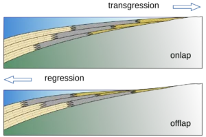
Geological diagram showing onlap and offlap deposition (Marine Regression).

MMarine Regression

A marine regression occurs when sea level falls relative to the land, exposing previously submerged areas and leading to the deposition of terrestrial sediments over marine sediments. Regressions are important for understanding changes in sea level, sedimentary environments, and the stratigraphic record. 

Reference: Catuneanu, O. (2006). “Principles of Sequence Stratigraphy.” Elsevier. 

Share 

Open entry →
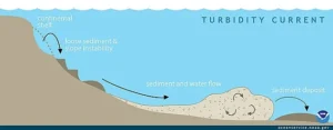
Diagram showing underwater turbidity current sediment flow (Marine Sedimentation)

MMarine Sedimentation

Marine sedimentation refers to the deposition of sediments in marine environments, including the deep sea, continental shelves, and coastal areas. The study of marine sediments provides insights into past ocean conditions, climate change, and the processes that govern sediment transport and deposition. 

Reference: Kennett, J. P. (1982). “Marine Geology.” Prentice-Hall. 

Share 

Open entry →

join.me

Geology made clear, in your inbox.

Get clear, visual explainers on rocks, minerals, deep time, and the most fascinating parts of Earth science from Geoscopy.
Dark basalt dike cutting through light granite rock (mafic dike)

MArchives: Glossary

A mafic dike is a sheet-like intrusion of mafic magma that cuts through existing rock layers. Dikes are important in understanding the processes of magma emplacement, the mechanics of crustal extension, and the formation of volcanic and plutonic rock bodies. 

Reference: Best, M. G. (2003). “Igneous and Metamorphic Petrology.” Wiley-Blackwell. 

Share 

Open entry →