Opens in a new tab
Geoscopy
Geology, explained.
Generic selectors
Exact matches only
Search in title
Search in content
Post Type Selectors

Rocks

An atlas of rocks and minerals: each one a record of the conditions that made it.

Glossary

Filter - Radio

Sort by

F

Fluvial

The term "fluvial" relates to processes associated with rivers and streams, including.. more →
F

Fluvial Sediments

Fluvial sediments are particles of rock, soil, and organic material that are.. more →
F

Fluvial Terrace

A fluvial terrace is a step-like landform that represents a former level.. more →
F

Foraminifera

Foraminifera are single-celled marine organisms with calcareous shells, often found in sedimentary.. more →
F

Foraminiferal Ooze

Foraminiferal ooze is a type of deep-sea sediment composed primarily of the.. more →
F

Forearc Basin

A forearc basin is a sedimentary basin located between a subduction zone.. more →
F

Foreland Basin

A foreland basin is a structural depression that forms adjacent to a.. more →
F

Formation (Geology)

A formation is a fundamental unit of lithostratigraphy, representing a body of.. more →
F

Formation Water

Formation water is the water that is trapped in the pore spaces.. more →
F

Fossil Fuel

Fossil fuels are energy resources such as coal, oil, and natural gas,.. more →
F

Fossil Record

The fossil record is the totality of fossilized remains found in sedimentary.. more →
F

Fossiliferous

Fossiliferous refers to sedimentary rocks that contain a significant number of fossils.. more →
F

Fossilization

Fossilization is the process by which organic remains are preserved in the.. more →
F

Fracture

A fracture is a break or crack in a rock where there.. more →
F

Fracture Zone

A fracture zone is a linear, oceanic feature characterized by a series.. more →
F

Frost Heaving

Frost heaving is the upward movement of soil or rock caused by.. more →
F

Frost Wedging

Frost wedging is a type of physical weathering that occurs when water.. more →
F

Fumarole

A fumarole is an opening in the Earth's crust, often near volcanoes,.. more →
G

Geochronology

Geochronology is the science of determining the age of rocks, fossils, and.. more →
G

Geodynamo

The geodynamo is the mechanism by which the Earth's magnetic field is.. more →
G

Geomorphology

Geomorphology is the scientific study of landforms and the processes that shape.. more →
G

Geopetal Structure

Geopetal structures are sedimentary features that indicate the original "way up" of.. more →
G

Geospeedometry

Geospeedometry is a technique used to estimate the cooling rates of rocks.. more →
G

Geostrophic Flow

Geostrophic flow is a type of fluid flow in which the Coriolis.. more →
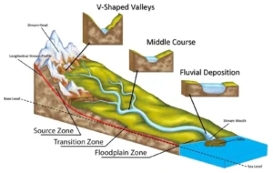
River course diagram showing zones and landforms (fluvial)

FFluvial

The term “fluvial” relates to processes associated with rivers and streams, including erosion, sediment transport, and deposition. Fluvial processes are key in shaping landscapes, forming river valleys, floodplains, and deltas. The study of fluvial systems is crucial in understanding hydrology, geomorphology, and sedimentary environments. 

Reference: Leopold, L. B., Wolman, M. G., & Miller, J. P. (1964). Fluvial Processes in Geomorphology. Dover Publications. 
Share 

Open entry →
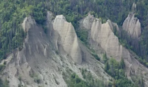
Eroded cliffs with dense forest vegetation (fluvial sediments)

FFluvial Sediments

Fluvial sediments are particles of rock, soil, and organic material that are transported and deposited by rivers and streams. These sediments can form various landforms, including deltas, alluvial fans, and river terraces. Fluvial sediments are essential in understanding sedimentary processes, river dynamics, and the reconstruction of past environmental conditions. 

Reference: Bridge, J. S. (2003). Rivers and Floodplains: Forms, Processes, and Sedimentary Record. Blackwell Publishing. 

Share 

Open entry →
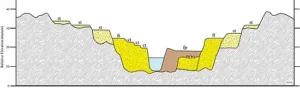
Cross-section diagram showing river valley layers and deposits (fluvial terrace)

FFluvial Terrace

A fluvial terrace is a step-like landform that represents a former level of a riverbed, formed by river erosion and deposition. Terraces are often used as indicators of past river activity, climatic changes, and tectonic uplift. They are important in the study of fluvial geomorphology, stratigraphy, and Quaternary geology. 

Reference: Bull, W. B. (1991). Geomorphic Responses to Climatic Change. Oxford University Press. 

Share 

Open entry →
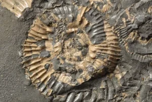
Close-up of ammonite fossil in rock (foraminifera)

FForaminifera

Foraminifera are single-celled marine organisms with calcareous shells, often found in sedimentary deposits. They are widely used in biostratigraphy, paleoceanography, and climate studies due to their sensitivity to environmental changes and their extensive fossil record. Foraminifera play a critical role in reconstructing past marine environments and the history of oceanic conditions. 

Reference: Murray, J. W. (2006). Ecology and Applications of Benthic Foraminifera. Cambridge University Press. 

Share 

Open entry →

FForaminiferal Ooze

Foraminiferal ooze is a type of deep-sea sediment composed primarily of the calcareous shells of foraminifera. This sediment is widespread in the world’s oceans and plays a crucial role in paleoceanography, as it provides a detailed record of past oceanic conditions and climate changes. 

Reference: Murray, J. W. (2006). Ecology and Applications of Benthic Foraminifera. Cambridge University Press. 

Share 

Open entry →
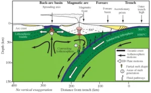
Diagram showing subduction zone and plate tectonic processes (forearc basin)

FForearc Basin

A forearc basin is a sedimentary basin located between a subduction zone trench and the associated volcanic arc. These basins accumulate sediments eroded from the volcanic arc and the overriding plate, and they play a crucial role in understanding subduction processes, sedimentary environments, and the tectonic evolution of convergent margins. 

Reference: Ingersoll, R. V. (1979). Evolution of the Late Cretaceous Forearc Basin, Northern and Central California. Geological Society of America Bulletin. 

Share 

Open entry →
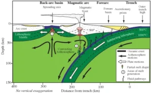
Diagram of plate tectonics and subduction zone formation (foreland basin)

FForeland Basin

A foreland basin is a structural depression that forms adjacent to a mountain range, resulting from the flexure of the lithosphere due to the weight of the mountain belt. These basins are filled with sediments eroded from the mountains and are key features in understanding the processes of mountain building, sedimentation, and basin evolution. 

Reference: DeCelles, P. G., & Giles, K. A. (1996). Foreland Basin Systems. Basin Research. 

Share 

Open entry →
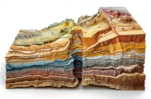
3D geological cross-section showing Earth's layered structure (formation)

FFormation (Geology)

A formation is a fundamental unit of lithostratigraphy, representing a body of rock with a distinct set of characteristics that distinguish it from adjacent rock units. Formations are used to map and describe the geology of an area, and they are key in understanding the distribution of rock types, sedimentary environments, and geological history. 

Reference: Salvador, A. (1994). International Stratigraphic Guide: A Guide to Stratigraphic Classification, Terminology, and Procedure. Geological Society of America.

Share 

Open entry →
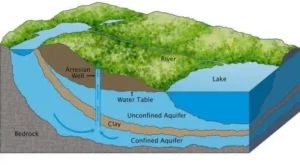
Diagram showing aquifers, artesian well, and water table (formation water)

FFormation Water

Formation water is the water that is trapped in the pore spaces of sedimentary rocks during their formation. This water can be saline and contains dissolved minerals, making it important in the study of hydrocarbon reservoirs, groundwater systems, and the geochemical history of sedimentary basins. 

Reference: Hanor, J. S. (1994). Origin of Saline Fluids in Sedimentary Basins. Geological Society.

Share 

Open entry →
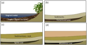
Stages of coal formation from peat to bituminous coal (fossil fuel)

FFossil Fuel

Fossil fuels are energy resources such as coal, oil, and natural gas, formed from the remains of ancient plants and animals over millions of years under high pressure and temperature. Fossil fuels are a major source of energy globally but are also associated with environmental concerns like greenhouse gas emissions and climate change. Understanding their formation, distribution, and impact is critical in geology, energy studies, and environmental science. 

Reference: Tissot, B. P., & Welte, D. H. (1984). Petroleum Formation and Occurrence. Springer.

Share 

Open entry →
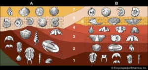
Geologic strata showing fossil distribution over time (fossil record)

FFossil Record

The fossil record is the totality of fossilized remains found in sedimentary rocks around the world, providing a chronological record of past life on Earth. It offers key evidence for the study of evolution, paleoenvironments, and the history of biodiversity. The fossil record is crucial in paleontology and helps to document the rise and fall of species over geological time. 

Reference: Benton, M. J., & Harper, D. A. T. (2009). Introduction to Paleobiology and the Fossil Record. Wiley-Blackwell.

Share 

Open entry →
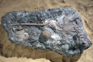
Crinoid fossil embedded in gray rock on sand (fossiliferous)

FFossiliferous

Fossiliferous refers to sedimentary rocks that contain a significant number of fossils or fossil fragments. These rocks, such as fossiliferous limestone or shale, are important in paleontology and stratigraphy, providing valuable information about past life, environmental conditions, and the age of rock layers. 

Reference: Prothero, D. R. (2004). Bringing Fossils to Life: An Introduction to Paleobiology. McGraw-Hill.

Share 

Open entry →
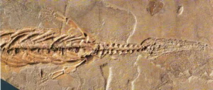
Fossil of ancient marine reptile embedded in rock (fossilization)

FFossilization

Fossilization is the process by which organic remains are preserved in the geological record, typically through processes such as permineralization, replacement, or impression. Fossilization provides critical evidence of past life, helping to reconstruct ancient ecosystems, evolutionary history, and environmental conditions. 

Reference: Allison, P. A., & Bottjer, D. J. (2010). Taphonomy: Process and Bias Through Time. Springer. 

Share 

Open entry →
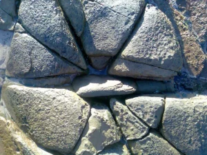
Close-up of irregular stone wall texture (fracture zone)

FFracture

A fracture is a break or crack in a rock where there has been no significant movement of the rock on either side of the crack. Fractures can occur due to stress, temperature changes, or other geological processes. They are significant in structural geology, hydrogeology, and petroleum geology, as they can influence fluid flow, rock strength, and the migration of hydrocarbons. 

Reference: Pollard, D. D., & Aydin, A. (1988). Progress in Understanding Jointing over the Past Century. Geological Society of America Bulletin.

Share 

Open entry →
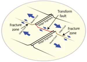
Diagram of oceanic ridge segments and transform faults (fracture zone)

FFracture Zone

A fracture zone is a linear, oceanic feature characterized by a series of fractures and faults, often associated with transform faults that offset mid-ocean ridges. These zones are important in understanding the tectonic processes that shape the ocean floor, the movement of tectonic plates, and the distribution of earthquakes in the oceanic crust. 

Reference: Sandwell, D. T., & Schubert, G. (1982). Lithospheric Flexure at Fracture Zones. Journal of Geophysical Research.

Share 

Open entry →
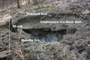
Needle ice formation beneath thawed forest soil (frost heaving)

FFrost Heaving

Frost heaving is the upward movement of soil or rock caused by the freezing and expansion of water in the ground. This process is significant in cold climates and can cause damage to roads, buildings, and other structures. Understanding frost heaving is important in geotechnical engineering, soil mechanics, and the study of periglacial environments. 

Reference: Andersland, O. B., & Ladanyi, B. (2004). Frozen Ground Engineering. John Wiley & Sons.

Share 

Open entry →
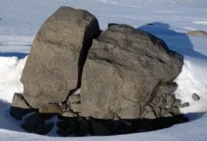
Large cracked rock surrounded by snow (frost wedging)

FFrost Wedging

Frost wedging is a type of physical weathering that occurs when water enters cracks in rocks, freezes, and expands, causing the rock to break apart. This process is common in cold climates and contributes to the breakdown of rocks into smaller fragments. Frost wedging is significant in the study of weathering processes, landscape evolution, and soil formation. 

Reference: Hall, K. (1986). The Role of Thermal Stress in the Breakdown of Rock in Cold Regions. Geological Society of America Bulletin. 

Share 

Open entry →
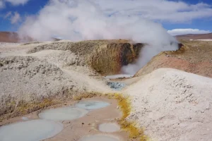
Steaming geothermal mud pools in rocky landscape (fumarole)

FFumarole

A fumarole is an opening in the Earth’s crust, often near volcanoes, that emits steam and gases such as carbon dioxide, sulfur dioxide, and hydrogen sulfide. Fumaroles are significant in volcanology for studying the degassing processes of magma, the chemical composition of volcanic gases, and the potential hazards associated with volcanic activity. 

Reference: Symonds, R. B., Rose, W. I., Bluth, G. J. S., & Gerlach, T. M. (1994). Volcanic-Gas Studies: Methods, Results, and Applications. In: Carroll, M. R., & Holloway, J. R. (Eds.), Volatiles in Magmas. Reviews in Mineralogy. 

Share 

Open entry →
Spiral clock overlay on Earth from space (geochronology)

GGeochronology

Geochronology is the science of determining the age of rocks, fossils, and sediments through the use of dating methods such as radiometric dating. This field is crucial for understanding the timing of geological events, the history of the Earth, and the age of different rock formations. 
Reference: Faure, G., & Mensing, T. M. (2005). Isotopes: Principles and Applications. Wiley.

Share 

Open entry →
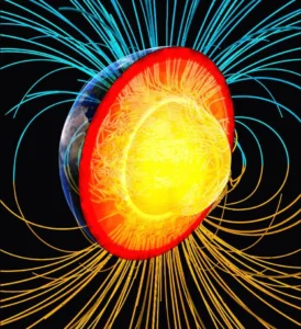
Earth core diagram with magnetic field lines (geodynamo)

GGeodynamo

The geodynamo is the mechanism by which the Earth’s magnetic field is generated through the motion of conductive materials in the Earth’s outer core. The geodynamo is crucial in understanding geomagnetism, the behavior of the Earth’s magnetic field over geological time, and its implications for plate tectonics and life on Earth. 
Reference: Glatzmaier, G. A., & Roberts, P. H. (1995). A Three-Dimensional Self-Consistent Computer Simulation of a Geodynamo. Nature.

Share 

Open entry →
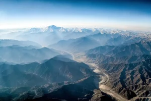
Aerial view of snowy mountain range and valley river (geomorphology)

GGeomorphology

Geomorphology is the scientific study of landforms and the processes that shape them. This field covers a wide range of topics, including the study of rivers, mountains, glaciers, deserts, and coastal regions. Geomorphology is crucial for understanding Earth’s surface processes, landscape evolution, and the interaction between climate, tectonics, and erosion. 
Reference: Summerfield, M. A. (1991). Global Geomorphology: An Introduction to the Study of Landforms. Routledge.

Share 

Open entry →
Close-up of a crystal geode in rock (geopetal structure)

GGeopetal Structure

Geopetal structures are sedimentary features that indicate the original “way up” of the rock at the time of deposition. These structures, such as graded bedding or fossils, are used to determine the orientation of rock layers in deformed or tilted sequences, making them important in structural geology and stratigraphy. 
Reference: Selley, R. C. (2000). Applied Sedimentology. Academic Press.

Share 

Open entry →

GGeospeedometry

Geospeedometry is a technique used to estimate the cooling rates of rocks and minerals by analyzing the diffusion profiles of specific elements within the minerals. This method is important in understanding the thermal history of igneous and metamorphic rocks, the rates of geological processes, and the conditions of rock formation. 
Reference: Lasaga, A. C. (1983). Geospeedometry: An Introduction to the Quantitative Measurement of Time in Petrology. Journal of Petrology.

Share 

Open entry →
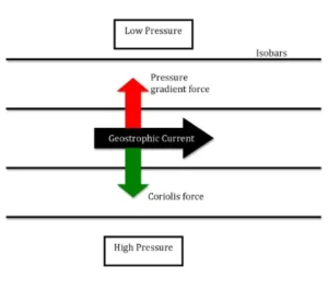
Diagram showing geostrophic current and pressure balance forces (geostrophic flow)

GGeostrophic Flow

Geostrophic flow is a type of fluid flow in which the Coriolis force due to the Earth’s rotation balances the horizontal pressure gradient force. This flow is commonly observed in large-scale ocean currents and atmospheric circulation patterns. Understanding geostrophic flow is important in oceanography, meteorology, and the study of Earth’s climate systems. 
Reference: Pedlosky, J. (1987). Geophysical Fluid Dynamics. Springer.

Share 

Open entry →

join.me

Geology made clear, in your inbox.

Get clear, visual explainers on rocks, minerals, deep time, and the most fascinating parts of Earth science from Geoscopy.
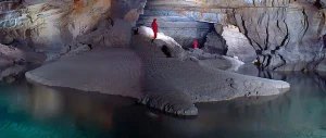
Explorers standing inside a large underground cave (subterranean river)

SArchives: Glossary

A subterranean river is an underground watercourse, often formed through the dissolution of soluble rocks, leading to the development of caves and karst landscapes. These rivers are significant in hydrogeology for understanding groundwater flow, aquifer systems, and the evolution of cave systems. 

Reference: Ford, D. C., & Williams, P. W. (2007). “Karst Hydrogeology and Geomorphology.” John Wiley & Sons. 

Share 

Open entry →