Opens in a new tab
Geoscopy
Geology, explained.
Generic selectors
Exact matches only
Search in title
Search in content
Post Type Selectors

Rocks

An atlas of rocks and minerals: each one a record of the conditions that made it.

Glossary

Filter - Radio

Sort by

H

Half-Graben 

A half-graben is a type of geological structure formed by extensional tectonics,.. more →
H

Hanging Valley

A hanging valley is a tributary valley that is elevated above the.. more →
H

Hanging Wall

The hanging wall is the block of rock that lies above an.. more →
H

Headward Erosion

Headward erosion is a process in which the upper part of a.. more →
H

Hemipelagic Sediment

Hemipelagic sediment refers to fine-grained sediments that accumulate on the continental slope.. more →
H

Heterogeneity (Geology)

Heterogeneity in geology refers to the variation in physical and chemical properties.. more →
H

Holocene

The Holocene is the current geological epoch, beginning approximately 11,700 years ago.. more →
H

Hornito

A hornito is a small, conical volcanic structure formed by the extrusion.. more →
H

Horst

A horst is an uplifted block of the Earth's crust bounded by.. more →
H

Hot Spot (Geology)

A hot spot is a location on the Earth's surface where a.. more →
H

Hot Spring

A hot spring is a natural geothermal feature where groundwater is heated.. more →
H

Humus

Humus is the dark, organic material in soil formed from the decomposition.. more →
H

Hyaloclastite

Hyaloclastite is a volcanic rock formed by the rapid cooling and fracturing.. more →
H

Hydraulic Conductivity

Hydraulic conductivity is a measure of a material's ability to transmit water.. more →
H

Hydraulic Fracturing

Hydraulic fracturing, commonly known as fracking, is a technique used to extract.. more →
H

Hydraulic Gradient

The hydraulic gradient is the slope of the water table or potentiometric.. more →
H

Hydraulic Head

Hydraulic head is a measure of the potential energy of groundwater, expressed.. more →
H

Hydrocarbon

Hydrocarbons are organic compounds composed of hydrogen and carbon atoms, forming the.. more →
H

Hydrogeology

Hydrogeology is the branch of geology concerned with the distribution, movement, and.. more →
H

Hydrographic Basin

A hydrographic basin, also known as a drainage basin or watershed, is.. more →
H

Hydrosphere

The hydrosphere encompasses all the water on Earth, including oceans, rivers, lakes,.. more →
H

Hydrostatic Pressure

Hydrostatic pressure is the pressure exerted by a fluid at equilibrium due.. more →
H

Hydrothermal Alteration

Hydrothermal alteration refers to the chemical alteration of minerals in rocks by.. more →
H

Hydrothermal Eruption

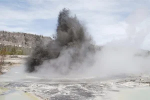
A hydrothermal eruption occurs when superheated water trapped beneath the Earth's surface.. more →
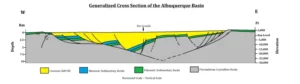
Geologic cross section of the Albuquerque Basin layers (half-graben)

HHalf-Graben 

A half-graben is a type of geological structure formed by extensional tectonics, where one side of a fault is down-dropped, creating a basin that is fault-bounded on one side. Half-grabens are significant in the study of rift systems, sedimentary basin development, and the tectonic evolution of extensional terrains. 

Reference: McClay, K. R. (1990). Extensional Fault Systems in Sedimentary Basins: A Review of the Geometry, Processes, and Evolution. AAPG Memoir 46. 
Share 

Open entry →
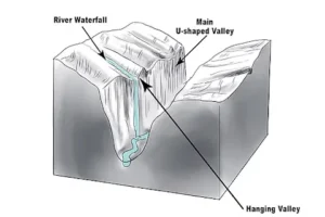
Diagram showing hanging valley and U-shaped valley.

HHanging Valley

A hanging valley is a tributary valley that is elevated above the main valley floor, often formed by glacial activity. As glaciers carve deep U-shaped valleys, smaller tributary glaciers create shallower valleys, which later become “hanging” when the glaciers retreat. Hanging valleys are important in studying glacial geomorphology and the evolution of mountain landscapes. 

Reference: Benn, D. I., & Evans, D. J. A. (2010). Glaciers and Glaciation. Routledge. 

Share 

Open entry →
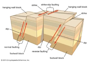
Diagram showing normal, reverse, and strike-slip faulting (hanging wall)

HHanging Wall

The hanging wall is the block of rock that lies above an inclined fault plane, as opposed to the footwall, which lies below the fault plane. The concept of hanging wall and footwall is essential in structural geology for describing and analyzing fault movements, especially in mining and petroleum geology. 

Reference: Twiss, R. J., & Moores, E. M. (2007). Structural Geology. W. H. Freeman. 

Share 

Open entry →
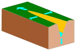
Diagram showing a divergent plate boundary formation (headward erosion)

HHeadward Erosion

Headward erosion is a process in which the upper part of a stream or river valley erodes back towards its source, effectively lengthening the river. This process is significant in understanding river dynamics, landscape evolution, and the development of drainage networks. 

Reference: Ferguson, R. I., & Werritty, A. (1983). Headward Erosion in a Small Scottish Catchment. Earth Surface Processes and Landforms, 8(4), 391-395. 

Share 

Open entry →
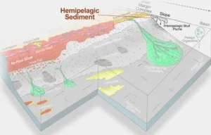
Diagram showing hemipelagic sediment formation on continental slope (hemipelagic sediment)

HHemipelagic Sediment

Hemipelagic sediment refers to fine-grained sediments that accumulate on the continental slope and rise, primarily consisting of a mixture of terrigenous and pelagic materials. These sediments are significant in understanding sedimentary processes in marine environments and can provide insights into past climate conditions and ocean circulation patterns. 

Reference: Carter, R. M., & McCave, I. N. (1997). Hemipelagic Sedimentation in the Deep Sea. In: Seilacher, A. (Ed.), Facies Models: Response to Sea Level Change. Geological Association of Canada. 

Share 

Open entry →
Colorful candy sprinkles background texture (heterogeneity (geology))

HHeterogeneity (Geology)

Heterogeneity in geology refers to the variation in physical and chemical properties within geological materials, such as rocks or soils. This variation can influence fluid flow, mechanical behavior, and geochemical reactions, and is significant in fields such as hydrogeology, petroleum geology, and environmental science. 

Reference: Pine, W. J., & Park, C. F. (2004). Geological Heterogeneity and Its Implications for Fluid Flow. Hydrogeology Journal, 12(1), 26-39. 

Share 

Open entry →
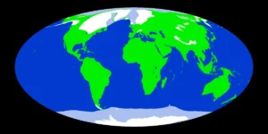
World map showing continents and oceans (holocene)

HHolocene

The Holocene is the current geological epoch, beginning approximately 11,700 years ago after the last major ice age. It is characterized by the development of human civilizations, significant climate changes, and the rise of agriculture. The Holocene is crucial in studying recent geological processes, climate history, and human impact on the environment. 

Reference: Walker, M. J. C., & Lowe, J. J. (2007). Quaternary Geology: A Stratigraphic Framework for Multidisciplinary Work. Geological Society, London, Special Publications, 242(1), 1-21. 

Share 

Open entry →
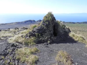
Volcanic rock formation on a grassy hillside (hornito)

HHornito

A hornito is a small, conical volcanic structure formed by the extrusion of lava through cracks in a solidified lava flow, often resembling a small spatter cone. Hornitos are important in understanding volcanic activity, the dynamics of lava flows, and the features associated with effusive eruptions. 

Reference: Parfitt, E. A., & Wilson, L. (2008). Fundamentals of Physical Volcanology. Blackwell Publishing. 

Share 

Open entry →
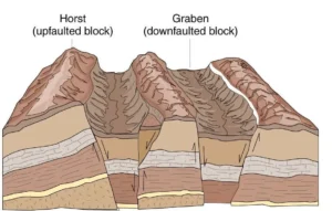
Diagram showing horst and graben fault blocks

HHorst

A horst is an uplifted block of the Earth’s crust bounded by normal faults on either side, typically forming elevated regions such as mountain ranges or plateaus. Horsts are significant in understanding extensional tectonics, crustal deformation, and the formation of rift valleys. 

Reference: Twiss, R. J., & Moores, E. M. (2007). Structural Geology. W. H. Freeman. 

Share 

Open entry →
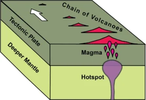
Diagram of hotspot creating volcanic island chain

HHot Spot (Geology)

A hot spot is a location on the Earth’s surface where a plume of hot mantle material rises, causing volcanic activity independent of tectonic plate boundaries. Hot spots can create volcanic island chains, such as the Hawaiian Islands, as the tectonic plate moves over the stationary plume. Studying hot spots helps geologists understand mantle convection, intraplate volcanism, and the formation of volcanic islands. 

Reference: Wilson, J. T. (1963). A Possible Origin of the Hawaiian Islands. Canadian Journal of Physics, 41(6), 863-870.

Share 

Open entry →
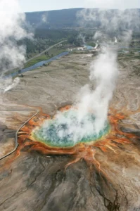
Aerial view of colorful geothermal hot spring

HHot Spring

A hot spring is a natural geothermal feature where groundwater is heated by the Earth’s internal heat and rises to the surface, often resulting in the formation of thermal pools. Hot springs are significant in geothermal energy, mineral deposition, and unique ecosystems that thrive in warm, mineral-rich waters. 

Reference: Miller, D. M. (1984). Geothermal Energy from Hot Springs. Geothermal Resources Council Bulletin, 13(3), 51-56. 

Share 

Open entry →
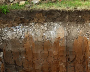
Soil profile showing distinct geological layers (humus)

HHumus

Humus is the dark, organic material in soil formed from the decomposition of plant and animal matter. It is essential for soil fertility, providing nutrients for plants and improving soil structure and moisture retention. Humus plays a crucial role in soil formation, agriculture, and the carbon cycle. 

Reference: Brady, N. C., & Weil, R. R. (2008). The Nature and Properties of Soils. Pearson.

Share 

Open entry →
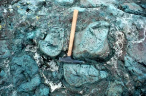
Geologist hammer on greenish pillow lava rocks (hyaloclastite)

HHyaloclastite

Hyaloclastite is a volcanic rock formed by the rapid cooling and fracturing of lava upon contact with water, typically during submarine or subglacial eruptions. This rock is composed of glassy fragments and is important in understanding volcanic processes in underwater or glaciated environments and the interactions between lava and water. 

Reference: Fisher, R. V., & Schmincke, H.-U. (1984). Pyroclastic Rocks. Springer.

Share 

Open entry →
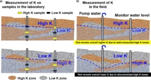
Comparison of laboratory and field K measurements in geology (hydraulic conductivity)

HHydraulic Conductivity

Hydraulic conductivity is a measure of a material’s ability to transmit water through its pore spaces or fractures. It is a critical parameter in hydrogeology, influencing groundwater flow, the design of wells, and the assessment of aquifers. Hydraulic conductivity depends on factors such as porosity, permeability, and the fluid’s viscosity. 

Reference: Bear, J. (1972). Dynamics of Fluids in Porous Media. Dover Publications. 

Share 

Open entry →
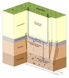
Hydraulic fracturing diagram showing rock layers and faults

HHydraulic Fracturing

Hydraulic fracturing, commonly known as fracking, is a technique used to extract oil and natural gas from deep underground reservoirs by injecting high-pressure fluid to fracture the rock. This process enhances the permeability of the rock, allowing hydrocarbons to flow more freely. Hydraulic fracturing is significant in the energy industry but also raises environmental concerns related to groundwater contamination and induced seismicity. 

Reference: Zoback, M. D., & Gorelick, S. M. (2012). Earthquake Triggering and Large-Scale Geologic Storage of Carbon Dioxide. Proceedings of the National Academy of Sciences, 109(26), 10164-10168. 

Share 

Open entry →
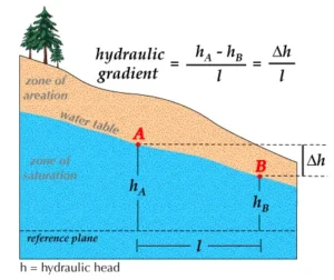
Diagram illustrating groundwater hydraulic gradient calculation.

HHydraulic Gradient

The hydraulic gradient is the slope of the water table or potentiometric surface, reflecting the change in hydraulic head per unit of distance. It is a crucial concept in hydrogeology, influencing groundwater flow direction and velocity, and is fundamental in the design of wells, drainage systems, and in the study of aquifers. 

Reference: Fetter, C. W. (2001). Applied Hydrogeology. Prentice Hall. 

Share 

Open entry →
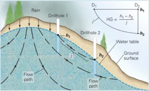
Groundwater flow and hydraulic gradient diagram (hydraulic head)

HHydraulic Head

Hydraulic head is a measure of the potential energy of groundwater, expressed as the height to which water would rise in a well. It is a key concept in hydrogeology for determining the direction and rate of groundwater flow, and is fundamental in the study of aquifers and groundwater management. 

Reference: Fetter, C. W. (2001). Applied Hydrogeology. Prentice Hall.

Share 

Open entry →
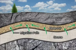
Oil and gas reservoir formation diagram (hydrocarbon)

HHydrocarbon

Hydrocarbons are organic compounds composed of hydrogen and carbon atoms, forming the basis of fossil fuels such as oil, natural gas, and coal. They are produced from the decomposition of organic matter under heat and pressure over millions of years. Hydrocarbons are a major source of energy globally, and their extraction and use have significant economic and environmental implications. 

Reference: Tissot, B. P., & Welte, D. H. (1984). Petroleum Formation and Occurrence. Springer.

Share 

Open entry →
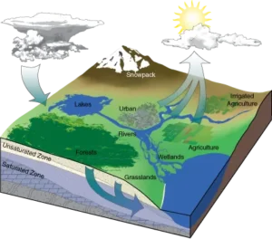
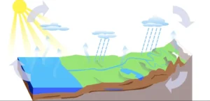
Water cycle diagram showing evaporation and precipitation (hydrogeology)

HHydrogeology

Hydrogeology is the branch of geology concerned with the distribution, movement, and quality of groundwater in the Earth’s crust. It encompasses the study of aquifers, groundwater flow, and the interaction between groundwater and surface water. Hydrogeology is essential for water resource management, environmental protection, and understanding the hydrological cycle. 

Reference: Fetter, C. W. (2001). Applied Hydrogeology. Prentice Hall.

Share 

Open entry →
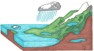
Diagram showing the water cycle process (hydrographic basin)

HHydrographic Basin

A hydrographic basin, also known as a drainage basin or watershed, is an area of land where all surface water converges to a single point, usually a river, lake, or ocean. The study of hydrographic basins is crucial in hydrology, water resource management, and environmental science for understanding the movement and distribution of water across the landscape. 

Reference: Chorley, R. J., & Kennedy, B. A. (1971). Physical Geography: A Systems Approach. Prentice Hall.

Share 

Open entry →
Diagram showing the water cycle process (hydrosphere)

HHydrosphere

The hydrosphere encompasses all the water on Earth, including oceans, rivers, lakes, glaciers, and groundwater. It plays a crucial role in the Earth’s climate system, the hydrological cycle, and the distribution of life. The study of the hydrosphere is essential for understanding water resources, environmental processes, and the impact of human activities on water systems. 

Reference: Kump, L. R., Kasting, J. F., & Crane, R. G. (2009). The Earth System. Pearson. 

Share 

Open entry →
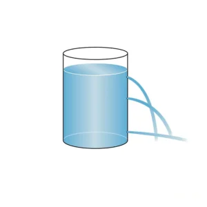
Water tank diagram with outlet pipes (hydrostatic pressure)

HHydrostatic Pressure

Hydrostatic pressure is the pressure exerted by a fluid at equilibrium due to the force of gravity. In geological contexts, it plays a crucial role in fluid dynamics, groundwater flow, and the behavior of subsurface fluids. Hydrostatic pressure is a key concept in hydrology, petroleum geology, and understanding fluid behavior in porous media. 

Reference: Bear, J. (1972). Dynamics of Fluids in Porous Media. Dover Publications. 

Share 

Open entry →
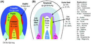
Hydrothermal alteration and ore shell zonation diagram

HHydrothermal Alteration

Hydrothermal alteration refers to the chemical alteration of minerals in rocks by hot, mineral-rich fluids, typically associated with volcanic activity or deep-seated geothermal systems. This process can lead to the formation of economically important ore deposits, such as gold, copper, and silver. Hydrothermal alteration is key in understanding mineralization processes and the evolution of hydrothermal systems. 

Reference: Guilbert, J. M., & Park, C. F. (1986). The Geology of Ore Deposits. Waveland Press.

Share 

Open entry →
Mud volcano eruption with steam and debris (hydrothermal eruption)

HHydrothermal Eruption

A hydrothermal eruption occurs when superheated water trapped beneath the Earth’s surface rapidly expands due to pressure release, causing an explosive release of steam, hot water, and rock fragments. These eruptions are common in geothermal regions and can significantly alter the landscape. Understanding hydrothermal eruptions is important in volcanic hazard assessment. 

Reference: Browne, P. R. L., & Lawless, J. V. (2001). Characteristics of Hydrothermal Eruptions, with Examples from New Zealand and Elsewhere. Earth-Science Reviews, 52(4), 299-331.

Share 

Open entry →

join.me

Geology made clear, in your inbox.

Get clear, visual explainers on rocks, minerals, deep time, and the most fascinating parts of Earth science from Geoscopy.
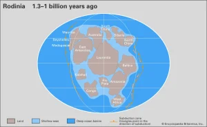
Map of Rodinia supercontinent 1.3 billion years ago

RArchives: Glossary

Rodinia was a supercontinent that existed during the Neoproterozoic era, approximately 1.3 billion to 750 million years ago. The study of Rodinia is significant for understanding the assembly and breakup of supercontinents, the evolution of Earth’s tectonic plates, and the environmental changes that led to the Snowball Earth events. 

Reference: Dalziel, I. W. D. (1997). “Neoproterozoic-Paleozoic Geography and Tectonics: Review, Hypothesis, Environmental Speculation.” Geological Society of America Bulletin, 109(1), 16-42.

Share 

Open entry →