Introduction
On the morning of 1 November 2011, a Hawaiian surfer named Garrett McNamara let go of a tow rope beneath the red lighthouse at Nazaré and dropped down the face of a wave later measured at 78 feet. That ride, and the canyon beneath it, is why the world knows this Portuguese fishing town, and the most popular explanation of how that canyon builds the biggest surfable waves on Earth is wrong.
A Wall of Water Under the Lighthouse
Nazaré waves are the largest ridden by human beings, and they break within sight of a clifftop fort. The scene has become one of the most recognizable in ocean sport: a surfer reduced to a speck on a moving mountain of white water, watched by a crowd pressed against the railings of the Farol da Nazaré. The question that draws geologists and surfers to the same clifftop is simple: why are the waves at Nazaré so big? Why here? Why does this one stretch of the Portuguese coast produce waves two or three times larger than those at beaches a short drive away that receive the same Atlantic storms?
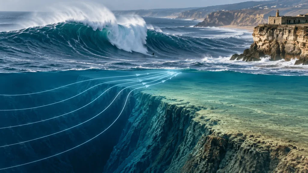
The short answer is that a submarine canyon lies just offshore. The longer answer is that the canyon does not do what almost every documentary and surf report says it does. It does not funnel or channel swell through its length toward the beach. New measurements released in 2026 indicate that the giant waves at Praia do Norte are built mostly by refraction and reflection along the steep northern edge of the canyon, which focuses wave energy into narrow beams aimed at the beach, where it combines with swell crossing the shallow shelf. The distinction matters, and getting it right changes how the whole phenomenon is understood.
The Email That Started Everything
For centuries the waves at Praia do Norte were something to be feared rather than sought. Local fishermen knew the sea north of the headland as a killer of boats. The idea that anyone would paddle out into it on purpose was absurd. That began to change in January 2005, when a Nazaré bodyboarder and municipal worker named Dino Casimiro pointed a camera at the giant walls of water striking the promontory and sent a photograph by email to Garrett McNamara, then one of the best-known big-wave surfers in the world. Casimiro had grown up watching those waves but had no human figure to give them scale; he suspected McNamara might supply one. “I saw a fantastic wave, but with no one surfing it. “I went crazy!” he later told SurferToday.
McNamara had never heard of Nazaré. Over the next five years he was kept informed of the best swells hitting the beach, and in November 2010 the municipality formally invited him to visit and assess the town’s big-wave potential for a couple of weeks. He ended up staying a month. He saw Praia do Norte break, and he recognized it immediately as something extraordinary. In the early days his partner (and future wife) Nicole spotted for him alone from the disused fort while locals, convinced the American was going to die, kept their distance.
He did not die. On 1 November 2011, towed in behind a jet ski during a session for the ZON North Canyon project, he rode a wave that Guinness World Records confirmed in May 2012 at 78 feet (23.77 meters), the largest wave ever surfed at the time, beating Mike Parsons’s 2008 ride at Cortes Bank. The most widely reproduced image of that wave, shot by the Portuguese photographer António Manuel Silva (“Tó Mané”), traveled around the world. Nazaré had a name and a number. McNamara later married Nicole at the lighthouse overlooking the break, and his pursuit of ever-larger waves became the spine of HBO’s documentary series 100 Foot Wave, which introduced the phenomenon to a mainstream audience.
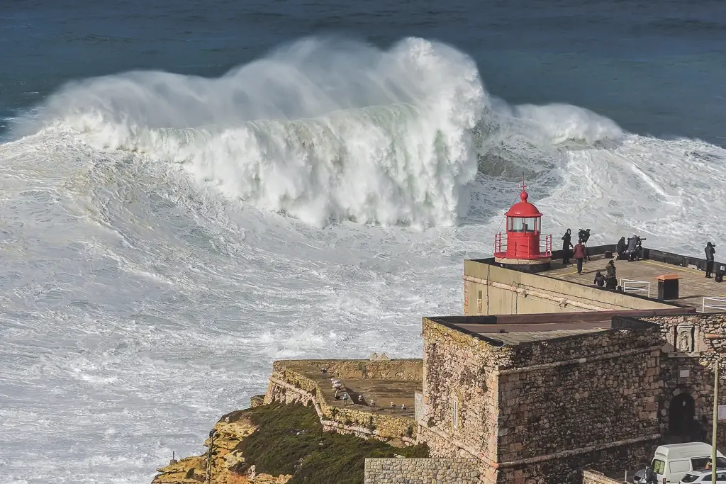
Giant surf at Praia do Norte breaking beneath the Farol da Nazaré and the Fort of São Miguel Arcanjo. Photo: Luis Ascenso, Wikimedia Commons, CC BY 2.0.
The Biggest Wave Ever Surfed: What Counts, and What Is Still Argued
After McNamara, the records fell in sequence, and every one of the men’s marks since has been set at Nazaré. On 8 November 2017 the Brazilian Rodrigo Koxa rode an 80-foot (24.38-meter) wave, officially breaking McNamara’s record. Then came the ride that still stands as the official world record.
Steudtner’s 86-Foot Wave: The Official Record
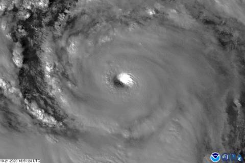
On 29 October 2020, during the swell generated by Hurricane Epsilon, the German surfer Sebastian Steudtner was towed into a wave at Praia do Norte by his partner “Alemão de Maresias.” Guinness World Records certified it at 26.21 meters (86 feet) measured from trough to crest, the largest wave ever surfed. The measurement was anything but instant. A team led by Adam Fincham, an engineering professor at the University of Southern California, working with colleagues from the Scripps Institution of Oceanography and the Kelly Slater Wave Company, spent about 18 months analyzing the footage. Fincham used Steudtner’s own lower leg, from heel to kneecap, as a physical ruler, then traveled to Nazaré to reconstruct camera angles and distances, interviewed the two photographers whose imagery was used, and applied 3D modeling to correct for perspective distortion before converting pixels to feet.
The certificate was presented on 24 May 2022 at the famous lighthouse above Praia do Norte, at the Fort of São Miguel Arcanjo, with a Guinness adjudicator and the World Surf League’s Jessi Miley-Dyer in attendance. “It’s an amazing feeling to finally hold the world record in my hands,” Steudtner said. As of 2026, that 86-foot wave remains the ratified record for the largest wave surfed.
The 2024 Wave: Bigger, but Not Yet Official
On 24 February 2024, Steudtner rode a wave at Nazaré that his team, working with Porsche Engineering, measured at 28.57 meters (93.73 feet) using a purpose-built drone. Porsche’s announcement, published on 19 April 2024, was candid about the wave’s status: “German big wave surfer Sebastian Steudtner has surfed what might be the biggest wave ever measured… Official confirmation of the new record is still pending.” That confirmation has not come; the 93.73-foot figure remains provisional and unratified, and the official record remains the 2020 wave.
Nazaré generates world-record claims almost every winter, and most evaporate. In January 2013 McNamara rode a wave widely reported as 100 feet; the number was never officially confirmed, and his 78-footer remained his record. The recurring pattern is a feature of the sport: a surfer tows into something enormous, someone says “world record,” the wave enjoys months of viral fame, and then the figure quietly fails to survive scrutiny. That is because measuring the height of a moving, breaking wave is hard.
Why Measuring a Giant Wave Is So Difficult
A wave has no fixed edges. Its face is curved, it moves fast, and the camera filming it sits at an angle and a distance that both distort the image. There are competing conventions, too: the Hawaiian scale measures the back of the wave rather than the face, and defining exactly where the trough sits beneath a churning surface is a judgment call. The industry-standard method (extract still frames, correct them geometrically for camera position and lens, then scale against a known object such as the surfer’s body) is painstaking and produces a number with real uncertainty attached. Drone-based measurement, of the kind Porsche developed, promises faster and more direct results, but the governing bodies have yet to ratify the 2024 figure. Officially, the biggest wave ever surfed is 86 feet; larger waves have probably been ridden; and the exact numbers will always carry error bars.
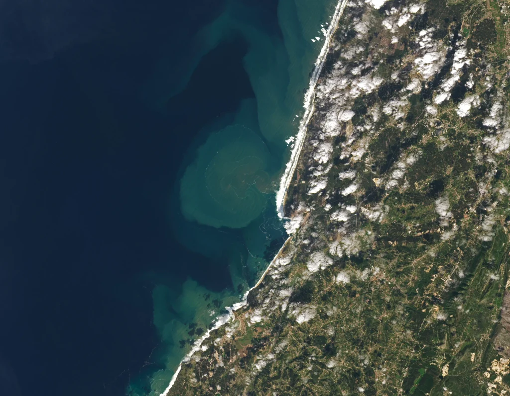
Landsat 8 captured the Nazaré coast on 29 October 2020, the day of Sebastian Steudtner’s record wave, with a broad band of breaking-wave foam along Praia do Norte and a sediment plume reaching roughly 10 kilometers offshore. Image: NASA Earth Observatory / Lauren Dauphin, using Landsat data from the U.S. Geological Survey (NASA Earth Observatory), Public Domain.
The Nazaré Canyon: Europe’s Largest Underwater Gorge
Everything about Nazaré’s waves traces back to a single feature on the seafloor. The Nazaré Canyon is the largest submarine canyon in Europe and one of the largest in the world, a vast cleft in the continental margin off central Portugal. Its dimensions depend on where you stop measuring, and the sources differ. The peer-reviewed synthesis by Tyler and colleagues (2009) states the canyon “extends ~210 km westward from the coast of Portugal, down to a water depth of >4300 m.” Wikipedia and some Portuguese sources cite roughly 200 to 230 kilometers in length and a maximum depth close to 5,000 meters at the Iberian Abyssal Plain. Taken together: about 210 to 230 kilometers long, reaching depths of somewhere between 4,300 and 5,000 meters.
For scale: the Grand Canyon in Arizona reaches a maximum depth of about 1,857 meters. At its deepest, the Nazaré Canyon is nearly three times deeper. Even the authors of the preprint that reframed how it works describe the canyon, where it cuts through the continental shelf, as ‘about half the size of the Grand Canyon’ in their plain-language summary. A reminder that ‘size’ depends on which dimension and which section you have in mind.
A Canyon That Reaches the Beach
Among the world’s great submarine canyons, Nazaré stands out for its position. Its head, the landward terminus, reaches almost to the sand at Praia do Norte: Portuguese sources commonly place it within a kilometer of the coast, and the 2026 paper maps the canyon to within about ten meters of the shoreline. The surrounding shelf there is only about 20 meters deep, while the canyon floor at its terminus lies at roughly 150 meters. From there the seabed plunges. Detailed bathymetric charts show that the surfers’ takeoff zone sits in 15 to 20 meters of water, while immediately to the south, at the canyon head, the depth is around 125 meters. At one location the seabed rises about 70 vertical meters over just 140 horizontal meters, a slope of roughly one-in-two, which is about as steep as ocean floors get. This abrupt underwater cliff, sitting a few hundred meters from the beach, is the geological engine of everything that follows.
Most coastlines do not work this way. Ordinarily, a swell rolling in from deep water crosses a wide, gently shoaling continental shelf, losing energy to friction and rearranging itself gradually over many kilometers before it reaches shore. At Nazaré, the deep water comes almost all the way in. Part of the incoming swell stays in deep water, and therefore keeps its speed and energy, until it is right at the beach, then interacts with the abrupt step at the canyon edge. That interaction, not a simple funnel, is where the giant waves are made.
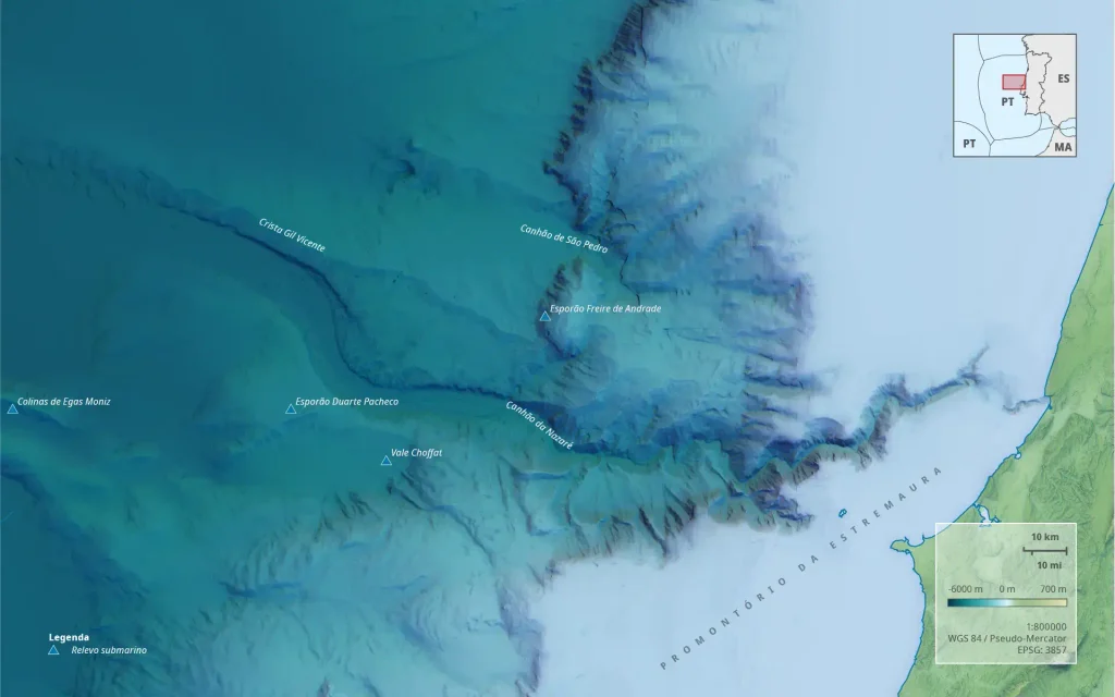
Bathymetric map of the Nazaré Canyon, whose head reaches almost to the shoreline at Praia do Norte. Image: Wikimedia Commons (see file page for uploader credit), CC BY-SA 4.0.
How the Canyon Was Carved: Faults, Landslides, and Turbidity Currents
Submarine canyons are common features of the world’s continental margins, NOAA Ocean Exploration notes that “there are at least 660 known submarine canyons worldwide, although few have been mapped extensively using modern methods”, but few are as large or as studied as Nazaré. They form through several processes acting over geological time. NOAA notes that canyons are “formed from various erosional processes, including rivers, biological activities… tidal currents, and internal waves.” During the Pleistocene, when sea levels repeatedly dropped, rivers cut incisions across exposed continental shelves and delivered huge volumes of sediment that carved and deepened canyons and built deep-sea fans at their mouths.
The Nazaré Canyon is an unusual case, because it is not fed by a modern river. Instead, its location appears to be controlled by geological structure. The canyon follows a line of weakness in the crust, described in the literature as a reactivated late-Hercynian (Variscan) fault zone, an ancient fracture in the Iberian basement that was reactivated by later tectonic movement. Along that structural corridor, the gorge was shaped over millions of years by mass wasting on its steep walls: landslides, debris flows, and turbidity currents.
Turbidity currents are the workhorses of submarine canyon erosion: in plain terms, underwater avalanches of sediment-laden water. When sediment is stirred into suspension (by a slope failure, an earthquake, a storm, or a river flood), the resulting mixture becomes denser than the clear water around it and races downslope along the seafloor, sometimes for hundreds of kilometers, scouring the canyon floor and walls as it goes. As Azpiroz-Zabala and colleagues wrote in Science Advances (2017), these “seabed-hugging flows called turbidity currents are the volumetrically most important process transporting sediment across our planet and form its largest sediment accumulations.” At Nazaré, present-day sediment input is dominated not by a river but by the capture of material drifting along the coast, which the canyon funnels down to the abyssal plain, a role that also explains why beaches south of the headland are starved of sand. The same principle that lets moving water carve enormous channels on land, as in the cataclysmic flood erosion of the Channeled Scablands, operates beneath the sea, where density-driven flows do the cutting.
An Origin Still Partly Open to Debate
The neat phrase “reactivated Hercynian fault” hides a live scientific disagreement. The canyon has long been classed as a “gouf”-type canyon, a term borrowed from the Gouf de Capbreton in France for canyons that cut across the entire shelf and connect the shoreline directly to the deep sea. A classic 1990 study by Vanney and Mougenot described the Nazaré gorge as established along a major late-Hercynian fault, the “Nazaré fault,” and reconstructed its evolution from the Middle Miocene onward. But in 2012, Dinis and colleagues presented an analysis with a pointed title: “The ‘Nazaré fault’: an illusion exposed by data analysis.” (Proceedings of the 7th Symposium on the Atlantic Iberian Margin, Lisbon, 16–20 December 2012, p. 43.) In other words, the very existence of a single through-going fault controlling the canyon has been questioned. The consensus that the canyon’s position is structurally influenced remains, but the details of exactly which structures, and how, are not fully settled. This is normal for a feature that is kilometers deep, hundreds of kilometers long, and buried under the Atlantic. The reactivation of ancient faults is a recurring theme in geology, from continental margins to the crustal structures behind events like Venezuela’s June 2026 earthquake doublet.
What Most Explanations Get Wrong: Focusing, Not Funneling
Here is the myth. Search almost anywhere and you will read that the Nazaré Canyon “funnels” or “channels” swell, that waves travel up the canyon like water down a pipe, keeping their energy while neighboring waves lose theirs on the shelf, so that the canyon acts as a deep-water highway delivering concentrated energy straight to the beach. It is tidy and intuitive, and, according to the most detailed measurements ever taken at the site, largely incorrect.
In 2026, an international team led by researchers at the Norwegian Meteorological Institute, the University of Washington’s Applied Physics Laboratory, +ATLANTIC in Portugal, and the National Research Council of Italy published a preprint titled “Focusing of Swell at the Nazaré Submarine Canyon” (Hope, Rainville, Seldal and colleagues). They deployed arrays of drifting wave buoys sampling the sea surface at high frequency above the canyon and mounted stereo cameras on the cliff overlooking the canyon edge, capturing the wave field at greater spatial and temporal resolution than any previous experiment there. They then modeled the swell using ray tracing and a boundary element method.
Their central finding, stated verbatim in the abstract, is this: “Swell traveling above the shelf is refracted and reflected at the canyon edge, where the phase speed increases abruptly due to the increased depth, resulting in a significantly focused wave field.” And, directly addressing the myth: “Contrary to the popular explanation that the large waves are channeled through the canyon, we find they are refracted and reflected along the canyon edge.” The mechanism is focusing, like light through a magnifying glass, rather than channeling, like water through a pipe.
Two further results sharpen the picture. First, the team found that waves with periods longer than about 7 seconds are mostly reflected at the canyon edge rather than crossing it, behavior they suggest is common to many submarine canyons worldwide. Second, they identified the swell directions that produce the biggest waves: “At Nazaré, optimal focusing occurs for waves arriving from about 275°–315°.” The model result matches surfers’ hard-won experience; the paper notes that the surfing community “considers waves arriving from about 290°–315° to yield the biggest surf.” The physics and the folklore agree.
One caveat: this is a preprint. It was received on 19 May 2026 and posted for open discussion on 1 June 2026, under review for the journal Ocean Science, and had not completed peer review as of this writing. The first referee report, filed on 22 July 2026 by Milan Curcic of the University of Miami, called it a paper that “makes a great leap forward toward better understanding the behavior of waves at Nazare” while asking for additional analysis and clearer figures. The conclusions are compelling and well-instrumented, but they are not yet the final, peer-accepted word.
How a Submarine Canyon Makes a Wave, Step by Step
Why does ‘focusing’ beat ‘funneling’? The physics unfolds in six steps.
1. Deep water lets waves keep their speed
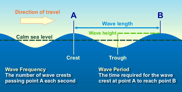
The speed at which a wave travels, its phase speed, or celerity, depends on the depth of the water beneath it. In shallow water, waves slow down; in deep water, they move fast. This single fact drives almost everything that follows. Because the Nazaré Canyon carries deep water nearly to the beach, swell above the canyon keeps traveling fast while swell over the adjacent shallow shelf is slowed.
2. The depth contrast bends the waves (refraction)
When part of a wave crest moves faster than the rest, the crest bends. This is refraction, the same effect that turns light rays passing between air and water, governed by Snell’s law. At Nazaré, the abrupt boundary between the deep canyon and the shallow shelf bends wave crests strongly. The part of the wave over the canyon races ahead and pivots; the part over the shelf lags. Refraction redirects wave energy toward Praia do Norte rather than letting it spread evenly along the coast.
3. The steep edge reflects long waves (reflection)
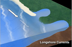
Where the depth changes not gradually but as a near-vertical step, refraction can become so extreme that the wave is effectively reflected, thrown back along the canyon edge rather than crossing it. This is the key insight of the 2026 study: the northern edge of the canyon acts less like a channel and more like a mirror for long-period swell, and the precise shape of that edge over the final few hundred meters determines exactly where the reflected energy is aimed. Because the process is so sensitive to the edge’s geometry, small variations in the shape of the canyon rim shift the entire pattern of where the waves concentrate.
4. The energy converges into beams (focusing)
Refraction and reflection together bend many wave rays toward the same small patch of coast, concentrating their energy, the magnifying-glass effect. Instead of a broad front of moderate waves, the beach receives narrow, intense beams of wave energy. This is the “significantly focused wave field” the researchers describe.
5. Two wave trains meet and add up (constructive interference)
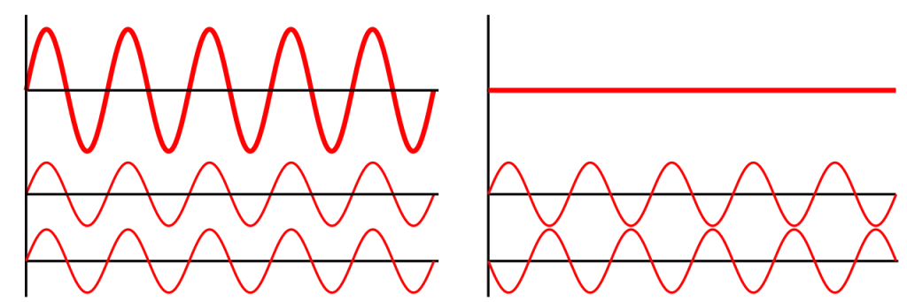
The wave refracted and reflected along the canyon edge arrives at the beach at the same place as swell that has crossed the shelf directly, but from a slightly different angle and at just the right moment. When two crests coincide, their heights add. This is constructive interference, and it can roughly double the resulting wave height. It also produces Nazaré’s signature shape: the steep, pyramid-like “A-frame” peak that seems to leap out of the sea, formed where two wave fronts intersect.
6. Shoaling stands the wave up at the last moment
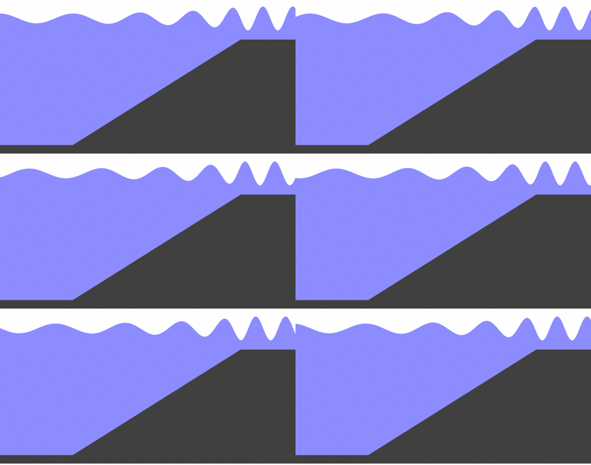
Finally, as the focused, combined wave reaches the shallow takeoff zone, it shoals. In shallowing water the wave slows and its energy is compressed into a shorter, taller form: wavelength decreases, height increases, and the wave rears up into the near-vertical face surfers drop into. Shoaling is the same process that makes a tsunami tower as it nears land; at Nazaré it is the final amplification on top of everything the canyon has already done.
Put together, the sequence is: deep water preserves speed, the depth contrast refracts and reflects the swell along the canyon edge, that energy is focused into beams aimed at Praia do Norte, the canyon-edge wave combines constructively with the shelf-crossing wave, and shoaling stands the merged peak up into a monster. Absent from that list: swell traveling lengthwise up the canyon. The canyon’s role is geometric: its edge shapes and aims the energy.
The Official Four-Factor Account, and How It Compares
Before the 2026 study, the standard technical explanation came from Portugal’s Instituto Hidrográfico (the Portuguese Navy’s Hydrographic Institute), which runs the MONICAN monitoring program at Nazaré. As summarized in the University of Coimbra synthesis by Cunha and Gouveia (2015) and elsewhere, the arrival of a strong west-northwest swell produces four effects:
- Wave refraction: the difference in depth between the shelf and the canyon changes the wave’s direction and speed.
- Overtopping of a topographic barrier (shoaling): the abrupt reduction in depth compresses the wave, shortening its wavelength and increasing its height as it nears shore.
- Constructive sum: positive interference between the wave arriving via the canyon and the wave crossing the northern shelf.
- A shore-parallel current: a current running along the coast, roughly north to south in the direction of the incoming waves, that further shapes the break.
The Instituto Hidrográfico’s models indicate the canyon can substantially amplify wave height. In its own words (translated from the Portuguese): “these combined mechanisms allow waves measuring 4 meters in the open ocean to reach heights exceeding 8 meters near the coast, and, in exceptional conditions, surpass 20 meters.” Surfline’s analysis puts the ceiling higher still, noting that “wave-face height can multiply three, four, even five times the offshore deepwater swell height,” though “this magnification is highly dependent on the incoming swell angle and period.” The Cunha and Gouveia synthesis records breaking waves estimated at 30 meters or more in the most extreme events.
The four-factor account and the 2026 preprint are not in flat contradiction; they overlap substantially on refraction, shoaling, and constructive interference. The important correction from the new work is about emphasis and mechanism. The older summaries, and especially their popular retellings, lean on the image of swell being funneled or channeled along the canyon. The new measurements say the dominant process is refraction and reflection along the canyon’s northern edge, with the fine-scale shape of that edge, not the length of the canyon acting as a channel, determining where the energy lands. It is a shift from “the canyon is a pipe” to “the canyon edge is a lens and a mirror.”
Why do optimal swells arrive from roughly 275° to 315°? Because that window aligns the geometry of refraction and reflection along the canyon’s northern edge with the orientation of the coast at Praia do Norte, so that the focused beams and the shelf-crossing swell converge at the takeoff zone at the same time. Swells from outside that arc strike the edge at angles that scatter the energy rather than concentrating it, and the waves, while still large, do not reach record scale.
Why It Remains Partly Open Science
For a phenomenon this famous, a surprising amount about Nazaré is unsettled. Three threads of uncertainty run through the story. The first is the canyon’s origin: the structural control on its location is accepted, but the specific role of faulting, even whether a single “Nazaré fault” exists, has been actively disputed in the literature. The second is measurement: the height of the biggest waves carries real error, drone methods are new and not yet ratified by the governing bodies, and the difference between an 86-foot official record and a 93-foot provisional claim sits inside that uncertainty. The third is the wave mechanism itself: the 2026 focusing study is the most detailed account yet, but it is a preprint under review, and its authors are careful to frame their findings as advancing, not closing, the question. A wave breaking a few hundred meters offshore, over a canyon kilometers deep, is a hard thing to pin down, and that mapping the seafloor precisely, as with the geophysical work behind the confirmation of the Silverpit impact crater, keeps rewriting what we thought we knew.

The Fort of São Miguel Arcanjo and the Farol da Nazaré, built into the fort in 1903, form the clifftop viewpoint above the break. Photo: Carlos Luis M C da Cruz, Wikimedia Commons, Public Domain.
The Human Cost: Why Praia do Norte Is So Deadly
The same physics that makes Nazaré thrilling makes it lethal. Because the waves break so close to shore, over the canyon rather than on a distant reef, a surfer who wipes out has little room and less time. The powerful shore-parallel current drags anyone in the water toward the cliff and the rocks; the worst place to end a ride is near the base of the headland. Surfers descend the faces at extreme speed, Porsche reported that Steudtner’s new Caçador RS board lets him “reach speeds of up to 100 km/h, compared to the previous 80 km/h”, and even a “small” day at Praia do Norte is heavy, dangerous water that only a few dozen people on Earth are equipped to handle.
For years the break produced terrifying wipeouts but no fatalities among the big-wave community. Maya Gabeira nearly died there on 28 October 2013: during a giant swell she broke her leg (a fractured fibula), lost consciousness, and was given CPR on the sand by her tow partner Carlos Burle after a mass of water, estimated by the BBC at around 144 tonnes, ripped off her lifejacket and held her under. Then came 5 January 2023, when the veteran Brazilian surfer Márcio Freire, one of the “Mad Dogs” who pioneered tow-free surfing at Jaws in Hawaii, died after a wipeout while tow surfing at Praia do Norte. He was 47. It was the first surfing death recorded at the break. According to the Port of Nazaré captain, a partner, Lucas ‘Chumbo’ Chianca, towed him to the beach already in cardio-respiratory arrest, and rescuers could not revive him. Warning signs stand on the beach even on calm summer days, and ordinary swimmers are told, unambiguously, never to enter the water at Praia do Norte.
Women’s big-wave history was written here too. Maya Gabeira returned from her near-drowning to set the first official women’s record at 68 feet in 2018 and raised it to 73.5 feet (22.4 meters) on 11 February 2020, the largest wave ridden by anyone, of any gender, that season.
The Best Seat in Big-Wave Surfing
Part of Nazaré’s fame is simply that you can watch it. The waves break a few hundred meters from a clifftop that rises roughly 100 meters above the sea, crowned by the Fort of São Miguel Arcanjo and the red Farol da Nazaré, the lighthouse built into the fort in 1903. Spectators standing at the railings are close enough to read the surfers’ body language as they drop in, an intimacy with giant surf that almost no other big-wave spot on Earth offers. The fort houses a small surf museum and an interpretive center, developed with the Instituto Hidrográfico, that explains the canyon with a three-dimensional model of the underwater valley. From the same clifftop you can look south to the sheltered town beach, Praia da Nazaré, calm and inviting, and grasp in a single glance the contradiction the canyon creates: two beaches, one headland apart, one of them safe for families and the other capable of producing the largest waves ever ridden.
Nazaré in the Wider Story of the Deep
Nazaré can look like a freak coincidence of geology and storm tracks. The canyon is also a window into processes that shape continental margins everywhere. Submarine canyons are among the most important conduits on the planet, moving sediment, and with it carbon and even plastic litter, from the shallow coast to the deep abyssal plain. The turbidity currents that carved Nazaré over millions of years are the same class of flows that build the world’s largest sediment deposits and that, in canyons like the Congo, carry, as Azpiroz-Zabala and colleagues measured, “~2% of the terrestrial organic carbon buried globally in the oceans each year through a single submarine canyon.” The behavior the 2026 study documents, long waves reflecting off a steep canyon edge, is, the authors argue, likely common to canyons around the world, which means Nazaré is a natural laboratory for understanding coastlines far beyond Portugal. The deep ocean and the deep Earth are full of such connections, from sediment-laden currents on the seafloor to the water locked inside the mantle far below.
Frequently Asked Questions
Why are the waves at Nazaré so big?
Because a huge submarine canyon reaches almost to the beach at Praia do Norte, bringing deep water, and fast-moving swell, close to shore. The steep northern edge of the canyon refracts and reflects incoming Atlantic swell, focusing its energy into narrow beams aimed at the beach. That focused wave combines constructively with swell crossing the shallow shelf, and shoaling stands the merged peak up into a giant. Measurements released in 2026 indicate the dominant mechanism is this focusing along the canyon edge, not swell being funneled up the canyon.
How deep is the Nazaré Canyon?
Estimates range from more than 4,300 meters (Tyler and colleagues, 2009) to about 5,000 meters at its deepest, where it meets the Iberian Abyssal Plain. For comparison, the Grand Canyon’s maximum depth is about 1,857 meters, making the Nazaré Canyon at its deepest nearly three times deeper. The shelf beside its head is only about 20 meters deep; the canyon floor at the head already lies at roughly 150 meters.
What is the biggest wave ever surfed at Nazaré?
The official record is a 26.21-meter (86-foot) wave ridden by Sebastian Steudtner on 29 October 2020, ratified by Guinness World Records, with the certificate presented at the Nazaré lighthouse on 24 May 2022. Steudtner rode a larger wave, measured at 28.57 meters (93.73 feet) with Porsche-engineered drone technology, on 24 February 2024, but that measurement remains unofficial and pending ratification.
Is Nazaré the biggest wave in the world?
Nazaré produces the largest waves that people have actually surfed, and every men’s world record since 2011 has been set there. Rogue and storm waves elsewhere have been measured higher, so it is not the site of the tallest waves ever recorded. For rideable waves, Praia do Norte is the undisputed arena.
Does the canyon channel or funnel the waves?
No, this is the most common misconception. The 2026 study “Focusing of Swell at the Nazaré Submarine Canyon” found that, contrary to the popular explanation, the large waves are not channeled through the canyon but are refracted and reflected along its edge, producing a focused wave field. The shape of the canyon’s edge in the last few hundred meters before the coast, not its length acting as a conduit, is what concentrates the energy.
When is the big-wave season at Nazaré?
The giant waves are seasonal, driven by North Atlantic storms, and typically occur between October and March, with the largest swells most likely from December to February. Outside that window the same beach can be relatively calm. The best swells for record waves arrive from roughly 275° to 315° (west to northwest).
How do scientists measure a wave that big?
Traditionally by extracting still frames from video, correcting them geometrically for camera position and lens distortion, and scaling against a known object, for Steudtner’s 2020 record, his own lower leg served as the ruler, in an analysis that took about 18 months. Newer approaches use drones to measure the wave and track the surfer directly. All methods carry real uncertainty, which is why big-wave heights are so often debated.
Conclusion: A Detective Story Written on the Seafloor
The story of why Nazaré waves are so big is, at heart, a geoscience detective story. The obvious suspect, a canyon funneling swell toward the beach, turns out to be the wrong culprit. The real mechanism is subtler: an ancient, fault-guided gorge, carved over millions of years by underwater avalanches, brings deep water to the doorstep of a beach, and the steep edge of that gorge acts as a lens and a mirror, bending and reflecting Atlantic swell into focused beams that combine and stand up into the largest waves anyone has ever ridden. The surfers, from McNamara to Steudtner, give the story its faces; underneath them, the canyon has been doing the work all along. A 2026 study has just reframed the mechanism, and honest uncertainty remains about the canyon’s origin and the true height of its biggest waves. That is what makes how giant waves form at Praia do Norte more than spectacle: a lesson in how the shape of the seafloor governs the sea.