Introduction
The Venezuela earthquake of 24 June 2026 began at 6:04 in the evening, when the ground along the country’s north-central coast lurched with a magnitude 7.2 shock. Thirty-nine seconds later, before the first set of seismic waves had finished rolling across the country, a second and larger shock arrived: magnitude 7.5. Two big earthquakes, almost on top of each other in time and in space, both beneath the hills southeast of the town of Yumare and about 170 kilometres west of Caracas. The United States Geological Survey gave the pairing a specific name in its first technical summary. It called the sequence a doublet.
Getting that one word right is the difference between understanding what happened in Venezuela and misreading it. This was not one earthquake followed by an ordinary aftershock. In a normal sequence the biggest shock comes first and everything afterward is smaller. Here the order ran the other way. The 7.5 was the main event, and it was preceded by a 7.2 that, on any other day, would itself have been the disaster on the front page. Two comparable mainshocks, separated by less time than it takes to read this paragraph aloud, demand an explanation that goes deeper than bad luck. The answer runs from the physics of how earthquakes pass stress to one another, down into the structure of a plate boundary that has been grinding through northern Venezuela for millions of years.
What happened: Venezuela’s 24 June 2026 doublet
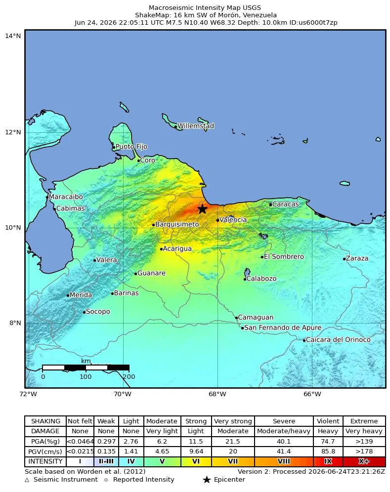
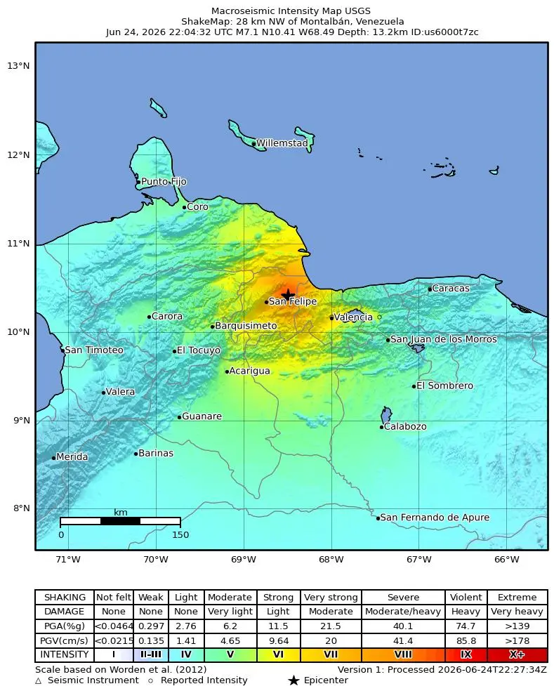
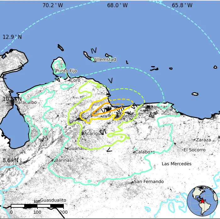
Start with the timeline. The seconds matter here more than they usually do. The first earthquake originated at 22:04:33 Coordinated Universal Time, which is 6:04 in the evening Venezuelan time. The USGS placed its epicentre at 10.44 degrees north and 68.53 degrees west, described by the USGS as about 24 kilometres east-northeast of San Felipe and close to the coastal town of Morón. The agency first announced it as a magnitude 7.1, upgraded it within the hour to 7.2, and settled on a focal depth near 22 kilometres. By the standards of this coastline, a shallow crustal earthquake of that size is already a major emergency.
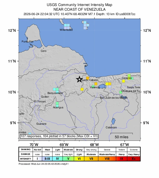
Then came 22:05:12. The second earthquake struck 39 seconds after the first, with its epicentre essentially in the same place: 10.45 degrees north, 68.51 degrees west, listed by the USGS as 23 kilometres southeast of Yumare, and also described as about 16 kilometres southwest of Morón. This one measured magnitude 7.5 at a depth of roughly 10 kilometres. The nearest large city is Puerto Cabello, home to more than 200,000 people. Valencia sits 64 kilometres to the southeast, Maracay around 104 kilometres east, and Caracas about 179 kilometres away, where the shaking registered as moderate rather than violent. The earthquake was felt across eight countries, from Colombia and the Dutch Caribbean islands to as far as the Dominican Republic and Guyana, and USGS exposure modelling placed roughly 26 million people in areas that experienced at least perceptible shaking.
How much bigger was the second shock? The moment magnitude scale is logarithmic, and the relationship between the number and the energy released is steep. Each whole step up the scale corresponds to roughly 32 times more seismic energy. A jump of 0.3, from 7.2 to 7.5, works out to about three times the energy. So Venezuela was hit first by a 7.2, and then, before the first earthquake’s vibrations had even cleared the country, by a second, larger event from almost the same patch of crust. Add the two together and the combined moment release is equivalent to something close to a magnitude 7.6.
Magnitude estimates, agency by agency
One of the honest difficulties of writing about an earthquake in its first hours is that the different monitoring agencies rarely agree on the exact figures, and this event is a textbook case. The disagreement is not a sign that someone is wrong. It reflects how hard it is to separate two earthquakes that overlap in time, recorded by a global network of seismometers from thousands of kilometres away.
The USGS resolved the sequence as two distinct events, the 7.2 and the 7.5, both calculated as moment magnitudes. The German Research Centre for Geosciences, GEOFON at GFZ Potsdam, did not separate them at all in its initial solution; it reported a single combined event of magnitude 7.3 at a depth of 12 kilometres. India’s National Center for Seismology logged a notably lower magnitude of 6.8 at 15 kilometres. The Colombian Geological Service issued a preliminary 7.1 with a shallow source near Morón. The European-Mediterranean Seismological Centre, like GFZ, initially carried a single event. The authoritative Global Centroid Moment Tensor catalog, which produces the rupture solutions seismologists treat as the long-term reference, had not yet published; that catalog typically lags real events by three to four months, so its solution for Venezuela is not expected until around September or October 2026.
Read those numbers side by side and a pattern emerges. Agencies that resolved the two shocks separately recovered the higher 7.5 figure for the larger one. Agencies that lumped the energy into a single solution landed between 7.1 and 7.3, because their algorithms were effectively averaging two overlapping ruptures into one. The lower 6.8 from a single station network is the kind of early outlier that usually gets revised upward as more data arrive. For a reader trying to hold the truth in mind, the cleanest summary is this: the USGS pairing of 7.2 plus 7.5 is the most complete picture available, the single-event solutions near 7.3 are not contradictions but a coarser view of the same energy, and every one of these values is preliminary.
Venezuela’s own national agency, the Fundación Venezolana de Investigaciones Sismológicas, known as FUNVISIS, issued bulletins and intensity maps, but it operated under a real handicap. The organisation is based in Caracas, and an earthquake of this size brings power outages and infrastructure damage to the very city where the seismologists work. A local network can locate aftershocks far more precisely than a distant global one, so FUNVISIS data will eventually sharpen the picture considerably. In the immediate aftermath, though, the most detailed information came from the USGS, assembled from felt reports submitted by people across those eight countries and from the global seismic network.
The 39-second gap: two shocks, one minute
The 39-second gap is the heart of the scientific story, and it creates a genuine puzzle. A magnitude 7.2 earthquake does not happen instantaneously. Its rupture takes tens of seconds to complete, with the tear in the rock racing outward from the point where it started, sometimes in two directions along the fault at once. So when the second earthquake began, the first one had only just finished, and the seismic waves from the 7.2 were still passing through the same region where the 7.5 was now tearing. The P-waves and S-waves of the second event arrived at the world’s seismometers buried inside the still-ringing shaking of the first.
This is why the agencies struggled to separate the two, and it is also why some seismologists analysing the event early on raised an alternative framing. The two shocks might be better thought of as two pulses of a single, larger rupture, with a brief pause in between, rather than as two fully independent earthquakes. Under that reading, the fault failed in one place, hesitated, and then failed again on an adjacent patch, producing what the instruments saw as two events but what the rock experienced as one drawn-out catastrophe lasting a minute or so. Whether you call it a doublet or a two-pulse rupture, the physical fact is the same: a fault released the energy of roughly a magnitude 7.6 in a single coupled episode, and the larger half came second.
What the shaking was like: intensity and ground acceleration

Magnitude alone does not tell you what it felt like to stand on that ground. Seismologists separate the size of an earthquake, its magnitude, from the strength of shaking at any given place, its intensity. Intensity is measured on the Modified Mercalli scale, which runs in Roman numerals from imperceptible up to total destruction, and it is anchored to what people feel and what buildings do rather than to energy released at the source. Near the epicentre of the 24 June mainshock, the modelled intensity reached the upper part of that scale, in the range of VIII to IX, the levels at which ordinary masonry cracks and collapses and even well-built structures sustain serious damage.
Behind the intensity sits a physical measurement: peak ground acceleration, the maximum rate at which the ground sped up as the waves passed. For this earthquake it was estimated near 0.68 g close to the source, meaning the ground accelerated at roughly two-thirds the acceleration of gravity. Acceleration of that magnitude throws unsecured objects off shelves, snaps brittle connections in buildings that were never engineered for it, and makes standing upright impossible. The damage that follows depends as much on what was built, and on what it was built on, as on the earthquake itself, a point that the geology of Caracas has driven home repeatedly over the past century and that returns later in this account.
What is a doublet earthquake?
The word doublet has a precise meaning in seismology. It describes a pair of earthquakes of comparable magnitude, close together in time and space, with similar focal mechanisms, where neither event is simply an aftershock of the other. The key qualifier is comparable size. An aftershock is, by definition, smaller than its mainshock and represents the crust around a rupture readjusting to the stress the big earthquake left behind. A doublet is two heavyweight punches rather than one punch and its echo.
How common is this? More common than most people would guess. A study by Yan Kagan and David Jackson, published in the Bulletin of the Seismological Society of America in 1999, looked at large shallow earthquakes worldwide and found that roughly 22 percent of events at magnitude 7.5 or above were accompanied by another earthquake of magnitude 7.5 or above within one rupture length, and within a time far shorter than the centuries-long interval you would expect between large earthquakes on the same fault from plate motion alone. Put plainly, when a very large earthquake happens, there is something like a one-in-five chance that another very large earthquake is lurking nearby in the days, hours, or even seconds that follow. The Venezuela sequence sits at the extreme short end of that distribution, with its two events 39 seconds apart.
There are well-documented precedents that make the Venezuela case less strange than it first appears. In August 2021, an earthquake near the South Sandwich Islands in the remote South Atlantic began as a magnitude 7.5 and was followed by a magnitude 8.1. The second event was again larger than the first, and it was partly concealed within the seismic waves of its predecessor, the same geometry that confused analysts in Venezuela and delayed recognition of just how big the South Sandwich sequence had been. The 2012 earthquakes off the coast of Sumatra in the Indian Ocean formed another famous doublet, a pair of enormous strike-slip events in the oceanic plate. And in February 2023, southern Türkiye was struck by a magnitude 7.8 earthquake and then, about nine hours later, by a magnitude 7.7 on a connected branch of the same fault system, a pairing that devastated a wide region of Türkiye and Syria and killed tens of thousands. Each of these carries the same lesson: large earthquakes can come in twos, and the second can equal or exceed the first.
How one earthquake triggers another: stress transfer
If a doublet is two big earthquakes nearly at once, the obvious question is what links them. Why should the failure of one patch of fault encourage the failure of another? The answer lies in how earthquakes redistribute stress in the crust, and it is one of the more satisfying ideas in modern seismology because it turns an apparent coincidence into cause and effect.
Think of the crust as a vast block of rock under steady strain, loaded over centuries by the slow grind of the plates. A fault that ruptures relieves the strain in one place, but it does not make the stress vanish. It moves it. Slip on the fault squeezes some neighbouring regions and stretches others, and the regions that get pushed in the wrong direction are nudged closer to their own breaking point. Geophysicists capture this with a quantity called the Coulomb stress change. Where an earthquake raises the Coulomb stress on a nearby fault, it brings that fault closer to failure, sometimes by an amount equivalent to years or decades of normal plate loading delivered in an instant.
This idea was put on a firm quantitative footing in a landmark 1994 paper by Geoffrey King, Ross Stein, and Jian Lin, who showed that the pattern of aftershocks around major earthquakes maps remarkably well onto the regions where the mainshock increased the Coulomb stress. Ross Stein laid out the broader implications in a widely read 1999 article in Nature, arguing that earthquakes are not independent dice rolls but events that talk to one another through the stress field, each one rewriting the odds for its neighbours. The mechanism comes in two forms. Static stress transfer is the permanent change in the stress field left behind after a fault slips, and it operates over distances comparable to the size of the rupture. Dynamic stress transfer is the transient jolt carried by the passing seismic waves themselves, which can trigger failure even at great distances if a fault is already poised on the edge. Andrew Freed’s 2005 review in the Annual Review of Earth and Planetary Sciences pulled these strands together and showed that both processes are real and both matter.
In Venezuela, with the two epicentres essentially co-located and only 39 seconds apart, both mechanisms would have acted almost simultaneously. The first earthquake’s slip would have instantly raised the static Coulomb stress on the immediately adjacent fault patch, and its seismic waves would have swept across that same patch at the same moment, delivering a dynamic kick on top. For an adjacent segment already close to failure after centuries of accumulated strain, that combined push appears to have been enough to set it off at once. The result was a chain reaction: one rupture triggering the next on a neighbouring strand of the same fault system, the failure of one patch loading the patch beside it past its limit.
The plate boundary beneath northern Venezuela
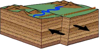
To understand why this stretch of coast was primed to fail, you have to zoom out to the scale of tectonic plates and then back down to the specific faults running beneath northern Venezuela. The country sits astride the boundary between two great plates: the Caribbean plate to the north and the South American plate to the south. This is not a boundary where one plate dives beneath the other, the way the Pacific seafloor plunges under South America’s western edge to build the Andes. Along Venezuela’s northern margin, the two plates are sliding horizontally past each other. It is a transform boundary, the same fundamental type as California’s San Andreas, and it produces the same fundamental kind of earthquake.
Why does the Caribbean plate move east? The plate is wedged between the much larger North American and South American plates, both of which are themselves drifting slowly westward as the Atlantic Ocean widens behind them. Caught in that vice, the Caribbean plate slips eastward relative to the Americas on either side of it, and at its leading eastern edge the old, dense floor of the Atlantic dives down beneath it along the curved trench of the Lesser Antilles, where the volcanic islands of the eastern Caribbean rise above the subducting slab. The northern and southern edges of the plate, against North and South America, take up that relative motion as transform boundaries. Venezuela’s coast is the southern one.
The motion is steady and measurable. Decades of GPS geodesy have pinned down how fast and in which direction the Caribbean plate moves relative to South America, and the answer is close to 20 millimetres a year, heading almost due east. A 2001 study by John Weber and colleagues in the journal Geology, using GPS data from across the boundary, found the Caribbean plate moving roughly eastward at about 20 millimetres per year along most of its southern edge. A companion study the same year by Omar Pérez and co-authors measured 20.5 millimetres a year, give or take 2, oriented just north of due east. Twenty millimetres a year sounds glacial, and over a human lifetime it is, amounting to less than a metre and a half. But faults do not creep along smoothly under that load. They lock, they accumulate strain for decades or centuries, and then they release it all at once. The slow eastward shove of the Caribbean plate is the bank account from which the 24 June earthquakes made their sudden, violent withdrawal.
What makes this margin geologically interesting is that the plate motion is not taken up by a single clean fault. The deformation is spread across a zone more than a hundred kilometres wide, partitioned among several large faults that each carry a share of the total movement. That distributed character is the structural signature of the whole northern Venezuelan margin, and it is the reason the region has so many seismic sources rather than just one.
Venezuela’s faults: Boconó, San Sebastián, and El Pilar
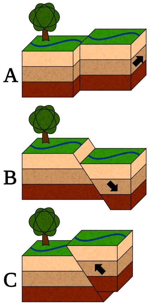
Three major faults dominate the system, and their names recur throughout the seismic history of Venezuela. Running from the southwest, the Boconó fault slices northeast through the Venezuelan Andes for about 500 kilometres. Where it reaches the central coast it connects with the San Sebastián fault, which runs roughly east to west along the shoreline north of Caracas. Continuing eastward, the baton passes to the El Pilar fault, another east-west structure that carries the deformation out toward the island of Trinidad. All three are right-lateral strike-slip faults, meaning that if you stood on one side and looked across, the far side would appear to move to your right. Together with companion faults to the west, such as the Oca-Ancón, and others to the east toward Trinidad, they form a fault system stretching well over 1,200 kilometres along the top of South America.
How the roughly 20 millimetres a year is divided among these faults has been worked out with GPS networks installed across the country. The picture that emerges is one of slip partitioning. In the eastern part of the boundary, past about 68 degrees west, the great majority of the right-lateral motion, on the order of 80 percent, is concentrated within a relatively narrow shear zone built around the El Pilar and San Sebastián faults. West of that, the Boconó fault through the Andes takes up a smaller but still substantial share, with geodetic and geological estimates placing its slip rate in the range of about 9 to 11 millimetres a year, and some trench and cosmogenic-dating studies suggesting Holocene rates anywhere from 4 to over 10 millimetres a year depending on the section. Frank Audemard, whose decades of fieldwork underpin much of what is known about active faulting in Venezuela, documented Holocene and historical earthquakes along the Boconó system and established it as one of the most active onshore faults in the country.
Locked and creeping fault zones
Not every part of a fault behaves the same way, and the difference decides where earthquakes can happen. Near the surface and down through the upper crust, rock is cold and brittle, and a fault there can lock, holding fast against the plate motion while strain builds, until it fails suddenly in an earthquake. That brittle, earthquake-generating zone, the seismogenic layer, typically extends down to about 15 kilometres along these faults before the rock becomes warm enough to flow rather than snap. The 24 June mainshock, at a depth near 10 kilometres, sits squarely within that brittle zone, which is exactly where the largest crustal earthquakes nucleate.
The El Pilar fault adds a complication that turns out to matter for hazard. Part of it does not lock fully. Geodetic surveys by Frédéric Jouanne and colleagues, and later detailed work by Carlos Reinoza and co-authors and by Lény Pousse-Beltran using satellite radar, found that the El Pilar fault is partly creeping, sliding aseismically in its upper crust rather than storing all its strain for earthquakes. Roughly half to 60 percent of the slip in the shallow crust along parts of the fault is accommodated by this slow creep, and the creep rate diminishes from west to east, from more than 25 millimetres a year on the western segment to around 13 on the eastern one. Creep is a double-edged property. Where a fault creeps, it bleeds off some strain harmlessly, which might seem reassuring. But creep on the shallow part of a fault does not prevent the deeper, locked portion from rupturing in a large earthquake, and the boundaries between creeping and locked patches can themselves be the places where ruptures begin or grind to a halt.
Which fault ruptured in 2026?
So which fault broke on 24 June? The focal mechanisms calculated by the USGS for both shocks are strike-slip, exactly what this transform margin should produce. For the magnitude 7.5 mainshock, one of the two possible fault planes in the solution runs nearly east to west with a strike of about 86 degrees, and that orientation lines up with the trend of the coastal strike-slip system. The earthquakes initiated near the structural junction where the northeast-trending Boconó fault meets the east-west coastal faults, in the region around Morón and Yumare. Importantly, the east-west fault plane does not match the northeast-southwest trend of the Boconó fault itself, which argues against the Boconó being the direct source and points instead toward the coastal, San Sebastián-aligned strands or an offshore fault near them.
That said, the precise named segment that ruptured is one of the genuine open questions in the days after the event. The USGS and independent analysts describe the source as the east-west right-lateral coastal system near the Boconó junction, but pinning it to a specific mapped fault, whether the San Sebastián, an unnamed offshore strand, or a local structure near Morón, will require the detailed analysis that comes later: the aftershock locations that trace out the ruptured area, and the finite-fault models that reconstruct how slip was distributed along it. A magnitude 7.5 earthquake typically ruptures something between 100 and 200 kilometres of fault, with several metres of slip on average, although early empirical scaling for this event suggested a rupture length closer to 90 kilometres. Because the epicentres lie about 170 kilometres west of Caracas, the direction the rupture travelled is not an academic detail. A rupture that propagated eastward, toward the capital, would concentrate energy very differently from one that tore westward, away from it.
Was there a tsunami? Why the warning was cancelled
Within minutes of the mainshock, the United States Tsunami Warning System flagged a tsunami threat for Puerto Rico and the United States and British Virgin Islands, and regional authorities warned of possible effects for the Dutch Caribbean islands of Aruba, Curaçao, and Bonaire, which sit just off the Venezuelan coast. About an hour later the threat was cancelled. No destructive wave arrived. For a coastal earthquake of magnitude 7.5, that sequence of a fast warning followed by a quick all-clear can look like a false alarm, but it is nothing of the kind. It follows directly from how tsunamis are made, and from the kind of fault that broke.
A tsunami requires one thing above all: the vertical displacement of a column of seawater. When the seafloor jumps up or drops down during an earthquake, it shoves the entire weight of water above it, and that displaced water spreads outward as a wave. The earthquakes that produce ocean-crossing giants, such as Sumatra in 2004 and Tōhoku in 2011, happen at subduction zones, where one plate is forced beneath another and the rupture lifts a huge area of seafloor by several metres in seconds, a sudden vertical kick to an enormous volume of water.
A strike-slip earthquake does something different with the ground. The two sides of the fault grind past each other horizontally, sliding side to side rather than thrusting up and over. Horizontal motion of the seafloor displaces very little water vertically, because shoving the seabed sideways does not raise or lower the column above it by much. This is the reason strike-slip earthquakes, even large ones, tend to be poor tsunami generators. The 24 June Venezuela mainshock was a strike-slip event on the coastal fault system, and its focal mechanism is precisely the type that moves a great deal of ground horizontally and almost no water vertically. The modest tsunami potential the warning centres calculated, and then stood down, is what the physics predicts.
There is an important exception, and it is why the warning was issued at all. Strike-slip earthquakes can still produce dangerous tsunamis indirectly, by shaking loose underwater landslides. A large earthquake near the coast can destabilise sediment piled on the steep slopes of the seafloor, and when that sediment slumps downhill it displaces water just as a vertical fault movement would, sometimes more violently inside a confined bay. The clearest modern example came in September 2018, when a magnitude 7.5 strike-slip earthquake struck near Palu on the Indonesian island of Sulawesi. By the simple fault physics it should have produced little tsunami, yet a wave several metres high swept into Palu Bay and killed a large number of people. The accepted explanation combines submarine landslides triggered by the shaking with the funnelling shape of the long, narrow bay, which amplified whatever wave was generated. A warning centre watching a large, shallow, coastal earthquake unfold cannot rule that scenario out in the first minutes, so it warns, and then cancels when the analysis shows the wave did not materialise.
Venezuela’s own coast has a precedent. The offshore earthquake of 1900, on this same plate-boundary system, reportedly disturbed the sea along the central coast, a reminder that tsunami hazard on this margin is real even though it is far smaller than at a subduction zone. Geography sharpens the concern. The Dutch Caribbean islands lie close offshore, and the shape of the seafloor across the southern Caribbean can focus wave energy in ways that are difficult to predict without detailed modelling. For 24 June the outcome was benign. The warning was precautionary, the landslide scenario did not unfold, and the sea stayed where it belonged. The episode illustrates why warning centres act fast on incomplete information and accept that some warnings will end in an all-clear, because the price of the rare missed tsunami is paid in lives.
Venezuela’s earthquake history: 1812 to today
The 2026 doublet did not arrive without warning from history. The same fault system has produced devastating earthquakes for as long as written records exist in Venezuela, and each one has left lessons about how often these faults fail and how much damage they can do. Four earthquakes in particular frame the hazard, and the oldest of them carries an eerie resemblance to what happened in June 2026.
1812: the Holy Thursday catastrophe
On 26 March 1812, Holy Thursday, the deadliest earthquake in Venezuelan history struck during the war for independence from Spain. Caracas was wrecked, and so were towns hundreds of kilometres apart. For two centuries the event has resisted being reduced to a single number, and modern macroseismic analysis offers a striking reason why. The 1812 catastrophe appears to have been not one earthquake but at least two separate large earthquakes on the same day, one near the Barquisimeto and San Felipe area on the Boconó fault, with an estimated magnitude around 7.4, and another closer to the coast that destroyed Caracas, on the San Sebastián fault, with an estimated magnitude near 7.1. Historical accounts describe shocks roughly half an hour apart, one ruining Caracas and another devastating Mérida far to the west. A double earthquake on these faults, in other words, is not a freak of 2026. It happened in 1812, and the difficulty of disentangling that older event from the historical record mirrors the difficulty seismologists faced two centuries later with their instruments.
The human cost of 1812 is debated as sharply as its magnitude. Traditional figures put the dead at 15,000 to 20,000 or more, and the USGS cites a combined toll near 30,000 across Mérida and Caracas, while careful archival reanalysis by the historian Rogelio Altez argues for a substantially lower count, closer to a few thousand. Whatever the true number, the political consequences were immense. Royalist clergy framed the earthquake as divine punishment for the rebellion, since it struck on a religious holiday and fell hardest on republican-held cities. The young revolutionary Simón Bolívar, surveying the ruins, is remembered for his defiant reply that if nature itself opposed the independence fighters, they would fight against nature and force it to obey.
1900: the offshore earthquake
On 29 October 1900, a large earthquake struck offshore of north-central Venezuela. Estimates of its magnitude run from about 7.6 to 7.7, and it was a strike-slip event on the same boundary system. Which fault produced it has been argued over, with candidates including the San Sebastián fault and the La Tortuga fault farther offshore. A 2015 study using high-resolution marine geophysical surveys of the seafloor leaned toward the San Sebastián fault as the more likely source. Until the events of 2026, the 1900 earthquake was among the largest instrumentally noted in the region, and its offshore location is the reason it appears again in the discussion of tsunami hazard above: an earthquake out under the seabed, on a coast otherwise dominated by onshore faults, is the configuration most capable of stirring the sea.
1967 Caracas: how soft soil amplified the damage
The earthquake that did the most to shape modern Venezuelan thinking about seismic risk was comparatively modest in magnitude. On 29 July 1967, a magnitude 6.5 to 6.6 earthquake struck about 20 kilometres from Caracas. According to FUNVISIS and contemporary records, around 280 people were killed and some 2,000 injured, with damage estimates running into the tens or low hundreds of millions of dollars. What made 1967 so instructive was not the size of the earthquake but the pattern of the destruction. Four modern apartment buildings, ten to twelve storeys tall, collapsed, and they were concentrated in specific Caracas neighbourhoods, Altamira and Los Palos Grandes, along with severe damage in the coastal resort area of Caraballeda.
The reason those particular buildings fell comes down to the ground they stood on. Caracas sits in a valley filled with soft sediments, and soft sediments amplify seismic shaking, especially at the frequencies that resonate with tall buildings. Where the sediment was deepest, the shaking was strongest and lasted longest, and the buildings whose natural sway matched that amplified motion were shaken apart while sturdier-seeming structures nearby survived. The 1967 earthquake became a foundational case study in how local soil conditions, not just earthquake magnitude, govern damage, and it drove revisions to seismic building codes in Venezuela and informed earthquake engineering far beyond it. The relevance to 2026 is direct and uncomfortable. Early reports from the June doublet again named Los Palos Grandes and Altamira among the hardest-hit parts of Caracas, the same neighbourhoods, the same valley sediments, nearly six decades later.
1997 Cariaco: the El Pilar fault ruptures
The most recent major earthquake on the system before 2026 came on 9 July 1997, near the town of Cariaco in eastern Venezuela. It was a magnitude 6.9 on the El Pilar fault, at a shallow depth of about 10 kilometres, and it killed somewhere in the range of 73 to over 120 people while injuring more than 500. The earthquake broke the surface, producing a rupture trace tens of kilometres long, on the order of 37 to 55 kilometres, marked by the right-stepping cracks and small pressure ridges characteristic of strike-slip faulting. Frank Audemard mapped that surface rupture in detail, and Michael Baumbach and colleagues analysed the aftershock pattern, work that tied the earthquake firmly to the El Pilar fault.
Cariaco carried two lessons that bear on 2026. The first is that the partly creeping El Pilar fault, despite bleeding off strain through aseismic slip, is fully capable of generating damaging earthquakes that rupture all the way to the surface. Creep buys no immunity. The second lesson was grimmer and more human. Several school buildings collapsed in the 1997 earthquake, a failure of construction rather than an act of nature, and it underscored that in this part of the world the gap between the earthquake a region can expect and the buildings it has actually built is where the casualties come from.
What recurrence means on a fault like this
String those events together and a rough rhythm appears, though it is not a clockwork one. The plate boundary loads its faults at roughly 20 millimetres a year, divided among several strands. A given segment that slips a few metres in a large earthquake needs centuries to rebuild that much strain at those rates, which is why any single stretch of the Boconó, San Sebastián, or El Pilar fault produces a great earthquake only every few hundred years. The catch is that the system has many segments, so while you wait centuries for any one of them, the boundary as a whole delivers a damaging earthquake somewhere in northern Venezuela far more often. That is the uncomfortable arithmetic a resident of the coast lives with. Any single fault is quiet for centuries, yet the network as a whole rarely stays quiet for long. The 2026 doublet is the latest release from a system the plates never stop loading.
What the 2026 doublet confirms, and what’s still unknown
Set against that history, the June 2026 earthquakes confirm several things and complicate others. The clearest confirmation is one of raw scale. The magnitude 7.5 mainshock is the largest instrumentally recorded earthquake on record in this particular region of Venezuela, exceeding even the 1900 offshore event in the instrumental catalog. The strike-slip mechanism confirms, once again, that this margin behaves as a transform boundary and produces the horizontal-shearing earthquakes that theory predicts. And the doublet character confirms that the partitioned, multi-fault structure of the boundary can fail in coupled episodes, where the rupture of one segment promotes the rupture of its neighbour, just as the stress-transfer studies of the past three decades would lead you to expect.
The complications are about detail, and they are the questions seismologists will spend months answering. Did the two shocks rupture the same continuous fault plane, with a 39-second pause, or two adjacent but distinct segments? How long was the total rupture, and which way did it propagate? Whether it tore toward Caracas or away from it changes the expected distribution of damage substantially, and the answer is written in data that had not yet been fully processed in the immediate aftermath. The locations of the aftershocks, once a local network and the global catalogs resolve them, will outline the ruptured area like chalk around a body. The finite-fault models will reconstruct the slip. The eventual Global CMT solution, months away, will provide the reference mechanism. Until then, every statement about the geometry of this rupture should be held loosely.
One further detail matters precisely because it is the kind of coincidence that breeds misinformation. A magnitude 6.9 earthquake struck Japan roughly half an hour after the Venezuela mainshock. The two are on opposite sides of the planet, and seismologists consider remote triggering across that distance from an earthquake of this size very unlikely. The timing is almost certainly coincidence, not cause, and the two events belong to entirely separate tectonic stories.
Casualties and damage (provisional, 25 June 2026)
Everything in this section is preliminary and will change, and the distinction between the two kinds of number here is easy to miss and easy to abuse. The USGS PAGER system issued a red alert, its highest level, for the mainshock. PAGER does not count bodies. It runs a statistical model that combines the shaking estimate with data on population and building vulnerability to produce a probability distribution of likely outcomes. For this earthquake, that model placed its highest probability, around 44 percent, on a fatality range between 10,000 and 100,000, with substantial probability spread into the neighbouring ranges, and it estimated a high likelihood of major economic losses, on the order of tens of billions of dollars and potentially far more relative to the size of Venezuela’s economy. Those are modelled probabilities, not confirmed counts, and they are best read as a warning about the possible scale rather than a tally.
The confirmed counts, as opposed to the modelled estimates, were far smaller in the first hours, as they always are early in a disaster when information is scarce and rescue is still underway. Reporting by the Associated Press, carried in live coverage on 25 June, quoted the acting president, Delcy Rodríguez, saying that at least 32 people had died and around 700 had been injured, with the explicit caveat that the number was expected to rise. The government declared a state of emergency, reported roughly 20 aftershocks, and closed the Simón Bolívar International Airport at Maiquetía because of damage. The interior minister, Diosdado Cabello, confirmed collapsed buildings and named Los Palos Grandes and Altamira in Caracas among the worst-affected areas, with damage reported across the states of Trujillo, Yaracuy, Carabobo, Miranda, Aragua, and La Guaira. The president of the National Assembly, Jorge Rodríguez, described the coastal state of La Guaira as the hardest hit, with as many as 15 buildings collapsed, and several collapses in the town of Catia La Mar were independently geolocated by international media.
Beyond the mainland, the brief tsunami concern described earlier passed without harm; the warning for Puerto Rico, the Virgin Islands, and the Dutch Caribbean was cancelled within about an hour and no damaging wave came ashore. As of 25 June, no formal situation report from the United Nations humanitarian agencies or the international Red Cross movement had yet been published, which is normal for an event barely a day old. Readers should treat any precise casualty totals circulating in unverified social posts or sensationalist outlets with caution; the figures that will stand the test of time are the ones eventually confirmed by named officials and humanitarian agencies, and those numbers were still days from settling.
What to watch next
A few specific developments will sharpen this picture in the coming weeks, and each one answers a question that the first day left open. The aftershock sequence, once relocated by FUNVISIS and the global networks, will trace the ruptured fault and reveal its true length and orientation. A finite-fault model from the USGS or academic groups will reconstruct how slip was distributed and settle whether the two shocks shared one fault plane or broke adjacent segments. The Global CMT solution, expected around September or October, will provide the long-term reference mechanism that the early moment tensors only approximate. And the first situation reports from humanitarian agencies will replace the provisional casualty figures with audited counts. Each of these is a point at which the story told here will need updating, and a careful reader should expect the numbers, and possibly some of the interpretations, to shift as the data mature.
What will not shift is the deeper reason this happened. A plate boundary that has been shoving Venezuela’s northern edge eastward for millions of years stores its motion in locked faults and then spends it in earthquakes. On 24 June 2026, two of those faults, or two segments of one, failed 39 seconds apart, and a coastline that has seen this in 1812, in 1900, in 1967, and in 1997 saw it again. The doublet was rare in its timing but ordinary in its cause. The rock was doing what this boundary has always done, on a schedule written not in human years but in the slow arithmetic of plate motion.