






Introduction
Fly east out of Seattle, cross the Cascades, and the green gives way to something that looks wrong. Wheat country rolls along in soft hills, and then the soil simply stops. What remains is bare black basalt, gouged into a maze of dry canyons and empty plunge pools, walled by cliffs that were plainly once waterfalls though no river runs over them now. Potholes drilled clean through solid basalt are deep enough to hold lakes. The land looks flayed. Early homesteaders called it the scablands, and they meant it as a complaint.
One man looked at that torn-up country and saw a single afternoon of violence. His name was J Harlen Bretz, and in the 1920s he argued that a flood of almost unimaginable size had ripped across eastern Washington in a matter of days. For that idea he was cornered at a scientific meeting and left to defend himself for the better part of forty years. He turned out to be right. The story of the Missoula Floods is partly about water and partly about how science decides what it is willing to believe.
What are the Missoula Floods?
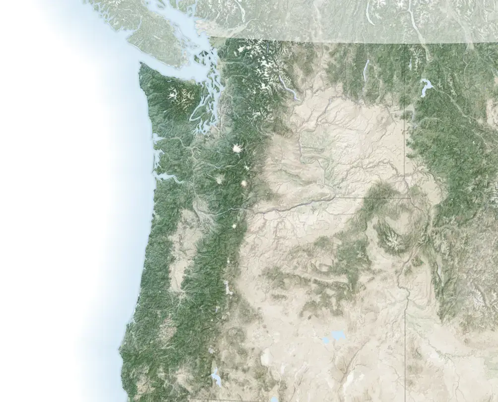
The Missoula Floods were a series of catastrophic glacial-lake outburst floods that swept across what is now eastern Washington, northern Idaho, and down the Columbia River toward the Pacific near the end of the last Ice Age. They carved the Channeled Scabland, a roughly 30,000-square-kilometre landscape of coulees and dry cataracts scoured into the basalt of the Columbia Plateau. That figure, and the modern framing of the whole story, comes from the major review by Jim O’Connor, Victor Baker, and colleagues published in Earth-Science Reviews in 2020.
The water came from Glacial Lake Missoula, a vast body of meltwater trapped in the mountain valleys of western Montana. An arm of the Cordilleran ice sheet, the Purcell Trench lobe, pushed south and blocked the Clark Fork River with a wall of ice about a kilometre thick. Behind that dam the lake rose and rose. When it failed, the lake emptied in a few days, and the released water tore westward across the plateau at highway speed. Then the ice re-formed and the cycle began again. According to O’Connor, Baker, and Waitt’s 2020 synthesis, the stratigraphy records dozens of separate late Pleistocene floods, likely more than a hundred, of which more than 25 in the lower Columbia valley had peak discharges exceeding one million cubic metres per second.
Bretz named the landscape and made the argument. The floods were first called the Spokane Flood, and only renamed the Missoula Floods once geologists accepted that the source was the Montana lake; in Bretz’s honour you will also see them called the Bretz Floods. Today the reality of the flooding is settled science. What geologists still argue about is the fine print: the count and timing of individual floods, and which valleys carried the water at any given moment.
Who was J Harlen Bretz?
Bretz was born in Saranac, Michigan, in September 1882, the oldest of five children of a farmer. His given name, according to his children, was actually Harley. He entered college in 1901 as “J. Harlen Bretz” and later dropped even the period after the J. He trained first as a biology teacher, taught physiography in Seattle high schools, and spent his weekends puzzling over the glacial geology of Puget Sound. That work earned him a place at the University of Chicago, where he finished a PhD in geology in 1913, summa cum laude, in two years.
He built a reputation as an expert on stream and glacial erosion, which matters to the story, because it meant he knew what ordinary rivers and glaciers could and could not do. In the summer of 1922 he took a field party of students into eastern Washington, and he kept going back every summer for the rest of the decade. It was rough work, much of it on foot, camping out of a Dodge sedan with a tent lashed to the front bumper. What he found there did not fit anything in the textbooks.
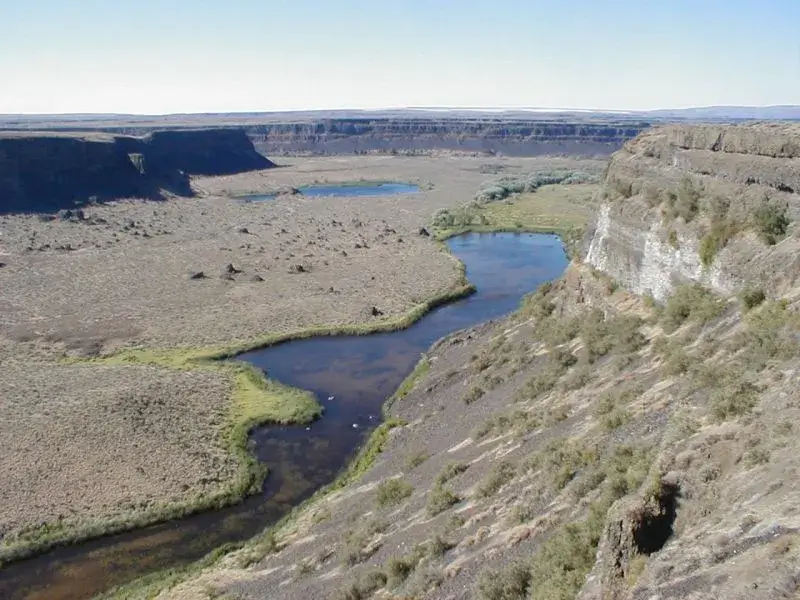
The channels were the first problem: enormous, bone dry, and floored with coarse gravel that had no local source. Whole tracts of prairie had been stripped to bare basalt. Granite boulders sat stranded on lava plains far from any granite, and abandoned cataracts loomed over country that catches roughly a quarter of the rain Seattle does. Bretz measured and mapped it all, and he arrived at a conclusion that appalled him as much as it would later appall everyone else. Only a sudden, enormous flood could have done this.
He laid it out in 1923 in a paper titled “The Channeled Scablands of the Columbia Plateau,” in the Journal of Geology. He wrote that ordinary river action could not explain what he saw, and he closed with a line that reads more like scripture than a research paper: “It was a debacle which swept the Columbia Plateau.” He was careful and empirical about the evidence on the ground. He was also, by every account including his own, stubborn and more than a little pleased with his role as the lone truth-teller. As he put it in 1928, “Ideas without precedent are generally looked upon with disfavor and men are shocked if their conceptions of an orderly world are challenged.”
Why did geologists reject Bretz’s flood?
The fury Bretz provoked grew out of what geology believed about itself in the 1920s. Since the late 1700s the science had organised itself around uniformitarianism, the doctrine championed by Charles Lyell and later distilled by Archibald Geikie into “the present is the key to the past.” Landscapes were shaped by slow, ordinary processes running for immense stretches of time. Rivers cut valleys grain by grain. Glaciers ground down mountains over millions of years. The doctrine had been hard-won, because it had pushed out an older way of thinking, catastrophism, which explained the rocks with sudden violent events and carried an unmistakable whiff of the biblical Flood.
So when Bretz proposed a single catastrophe on a nearly Noah-like scale, his colleagues heard a reversion to pre-scientific superstition. It did not help that Bretz had a gaping hole in his own argument. He could describe the effects of the flood in obsessive detail, but he could not say where the water had come from. He gestured vaguely at melting glaciers near Spokane, without explaining how that much ice could melt that fast.
The confrontation came on 12 January 1927, at a meeting of the Geological Society of Washington, D.C. Bretz was invited to present his hypothesis, and the room was stacked against him. Six other geologists rose in turn to rebut him. Bretz, nearly 45 and a tenured Chicago professor, later called them the “challenging elders.” His idea was denounced as preposterous and incompetent. The main objection was always the same, and it was fair: no source for the water.
Sitting in that audience, or closely tied to the debate around it, was a quiet U.S. Geological Survey geologist named Joseph Thomas Pardee, and Pardee already knew where the water had come from. He had described Glacial Lake Missoula in a paper back in 1910. Years later, Stephen Jay Gould pointed out in his essay collection The Panda’s Thumb that Bretz’s critics were not simple dogmatists. They had genuine reasons to doubt a story with no plausible cause. The tragedy was that the cause existed, and almost nobody put the two halves together.
What caused Glacial Lake Missoula to burst?
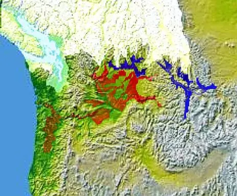
Glacial Lake Missoula formed the way a bathtub fills when you drop a towel over the drain. As the Cordilleran ice sheet advanced during the last glaciation, the Purcell Trench lobe crossed the Clark Fork valley near the present Idaho-Montana border and plugged it with glacier ice. Meltwater and river flow backed up behind the barrier and filled the intermountain valleys of western Montana. At its fullest the lake stood nearly 600 metres (about 2,000 feet) deep against the dam and held roughly 2,100 cubic kilometres of water, about the modern volume of Lake Erie and Lake Ontario combined, according to USGS geologist Richard Waitt’s reconstruction.
An ice dam is a poor dam. Ice is slightly less dense than water, so a glacier starts to lift off its bed once the lake behind it climbs to roughly nine tenths of the ice’s thickness; in Lee’s reconstruction the barrier stood about 2,200 feet thick, and the water behind it had reached 2,000. Once water started forcing its way through and under the ice, the failure ran away with itself. Tunnels widened until the barrier collapsed and the lake drained catastrophically. Estimates put the drainage at a few days. Then the glacier readvanced and plugged the valley again. Early in the lake’s history a refill took as long as a century; by the last few floods, varve counts show, the cycle had tightened to a year or two.
Pardee had the first piece as early as 1910, and in 1925 he actually wrote to Bretz to suggest that a collapse of the ice dam holding Lake Missoula could unleash a mighty flood. Bretz mentioned the possibility in passing in a 1933 paper and then let it drop. Gould’s verdict was blunt: Bretz “seemed singularly uninterested in finding the missing piece that would render his story coherent.” He kept documenting the flood’s effects in Washington and never went looking for its cause one state to the east. As for Pardee, he seems to have been discouraged from pushing such a heretical idea by his superiors at the Survey, among them W. C. Alden and Kirk Bryan. So he sat on it. For years.
How big were the Ice Age floods?
The numbers outrun intuition. A widely cited synthesis by Keenan Lee of the Colorado School of Mines describes a flood wall close to 2,000 feet high, roughly 600 metres, advancing at up to 100 miles per hour, around 160 kilometres per hour. Peak discharge in the Spokane Valley has been estimated at 17 ± 3 million cubic metres per second, with drainage of the lake taking several days, a figure carried in the 2020 review and its supporting hydraulic work. Lee’s account frames the raw force with a memorable comparison: a discharge that would drain Lake Erie dry in about eight hours. These are reconstructions rather than measurements, and different reaches and different floods give different figures, so they are best treated as sourced estimates. Lee himself notes that Pardee’s own 1942 calculation at the Montana outlet, based on a flood velocity around 45 miles per hour, worked out to about 386 million cubic feet per second, roughly 10.9 million cubic metres per second.
The landmarks the water left behind carry the scale better than any figure. Take Dry Falls, near Coulee City. Today it is a dry, scalloped cliff about 400 feet (120 metres) high and three and a half miles (5.6 kilometres) wide, faced by empty plunge pools. At full flood it was a waterfall roughly five times the width of Niagara, with water pouring over the lip at around 65 miles per hour. When it ran, it was very likely the largest waterfall that has ever existed on Earth. It ran dry the moment the flood stopped.
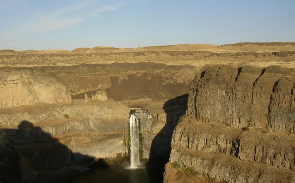
Palouse Falls, further south, still carries water. The Palouse River drops about 200 feet (61 metres) over a basalt escarpment into a canyon around 377 feet (115 metres) deep, and the whole gorge is a flood scar. The floods overtopped the old valley wall, gouged a new channel to the Snake River, and captured the river into its present course. The modern trickle is far too small to have cut the canyon it falls into.
Then there is the choke point at Wallula Gap, a single roughly one-mile-wide notch in the Horse Heaven Hills through which all of that water had to squeeze. It could not pass fast enough, so the flow backed up into a temporary lake, Lake Lewis, that spread across the Pasco Basin and drowned the Walla Walla and Yakima valleys under hundreds of feet of ponded water. Further downstream, when the flood squeezed through the Columbia River Gorge and reached the site of modern Portland, another constriction at Kalama Gap northwest of the city backed water 120 to 150 metres deep in the Portland basin and pushed floodwater roughly 200 kilometres south into the Willamette Valley, according to USGS mapping by Minervini, O’Connor, and Wells in Open-File Report 03-408.
The floods carried more than water. Icebergs calved off the failed dam and rode the flood downstream, each one freighted with boulders frozen into its base. When they grounded and melted, they dropped their cargo. That is why granite and other exotic rocks, ice-rafted erratics, sit stranded on hillsides in the Willamette Valley hundreds of kilometres from any matching bedrock. The same USGS report catalogues approximately 400 such erratics in the Willamette alone, most compiled from the early 20th-century notes of A. M. Piper and I. S. Allison.
The ripples that broke the case open
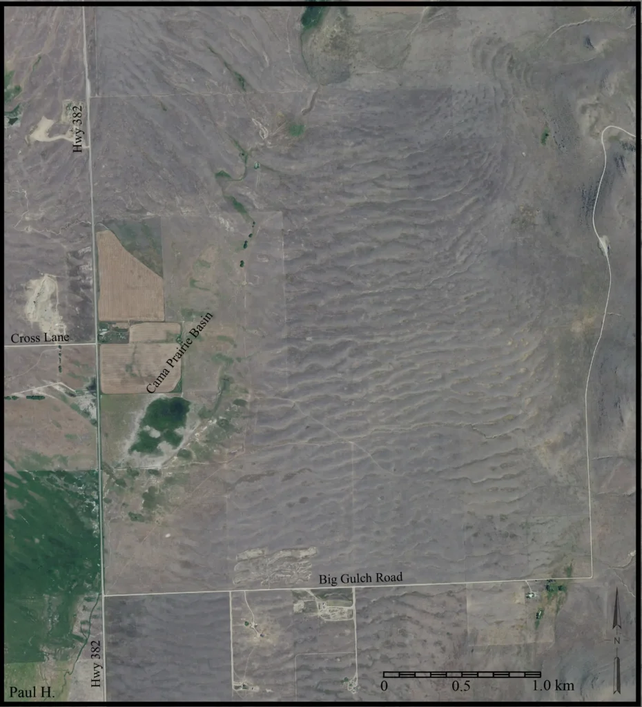
The single most persuasive piece of evidence sits not in Washington but in Montana, on the Camas Prairie. From the ground it reads as gently rolling grassland. From the air it resolves into rank after rank of enormous parallel ridges, and those ridges are current ripples, the same shape a stream leaves in sand on a riverbed, scaled up to monstrous size. The Ice Age Floods Institute describes the Camas Prairie ripples as prominent ridges 15 to 50 feet high, 100 to 250 feet wide, and from 300 feet to half a mile long, the largest such bedforms on Earth. The site was made a National Natural Landmark in 1966.
Ordinary ripples are made of sand and stand a few centimetres tall. These are built of gravel, cobbles, and boulders, and they stand as tall as a house. A ripple’s size scales with the strength of the current that shapes it, so ripples like these demand a current almost impossible to picture. They are the fingerprint of a flood, and they were formed as the deep water of Lake Missoula surged out through the passes of the Camas basin.
How was Bretz finally proven right?
The turn began on 18 June 1940, at a meeting of the American Association for the Advancement of Science in Seattle. The session was on the Quaternary geology of the Pacific, and Bretz, ever prickly, declined to attend, saying his evidence could speak for itself. The last speaker was Joseph Pardee, then near retirement and a far quieter man than Bretz. He read a paper with the diffident title “Ripple Marks (?) in Glacial Lake Missoula.” He described current ripples in Montana as much as 50 feet high, spaced hundreds of feet apart, and he argued that they recorded the sudden draining of the lake. He had finally said in public what he had held privately for thirty years. He published the full account in 1942 in the Geological Society of America Bulletin as “Unusual currents in glacial Lake Missoula, Montana.”
That was the missing source. With the lake and the scablands finally joined, the flood hypothesis finally had a cause and a mechanism to match its body of physical evidence. Acceptance still came slowly. Aerial photographs shot by the Bureau of Reclamation around 1950 for the Columbia Basin irrigation project revealed giant ripple fields in Washington too, patterns so large that no one on the ground had recognised them. Bretz, nearly 70 and officially retired, went back to the field in 1952 and documented fifteen ripple fields. In 1959 he concluded there had been not one flood but several, all fed by the repeated filling and emptying of Lake Missoula. As he wrote, “the addition of two and two to make four occurred, a simple addition that should have been made much earlier.”
By 1965 the profession had come around. A field excursion to the Columbia Basin was organised for a meeting of the international Quaternary research community, and the geologists on it saw the evidence with their own eyes. Bretz was too unwell to go. Afterward the party sent him a telegram of salutations that ended with a line now quoted in nearly every account of the affair: “We are all now catastrophists.” Bretz, then in his eighties, reportedly said the message did his heart good like medicine after thirty years and thirty papers of self-defence.
The last flourish came from orbit. In 1974 satellite images made the full scale of the channeled network visible from 570 miles up, and The New York Times reported that a photograph from space had at last confirmed the scope of the prehistoric catastrophe. Five years after that, in 1979, the Geological Society of America awarded Bretz its highest honour, the Penrose Medal. He was 96. He had outlived nearly everyone who had ridiculed him, and he knew it. He reportedly told his son, “All my enemies are dead, so I have no one to gloat over.” He died in 1981, at 98.
How many floods were there?
The reality of catastrophic flooding is not in question. The count and timing of individual floods very much are, along with the routes the water took, and the numbers have moved as dating methods improved.
Careful stratigraphy in slackwater deposits, where each flood dropped a distinct layer of silt separated by thin soils and volcanic ash, lets geologists count events. Work by Gerardo Benito and Jim O’Connor, published in the Geological Society of America Bulletin in 2003, found more than 25 floods with discharges above one million cubic metres per second in the Columbia valley between the Pasco Basin and Portland, at least 15 above three million, six or seven above 6.5 million,and at least one exceeding 10 million cubic metres per second. The 2020 Earth-Science Reviews synthesis places most of the flooding between roughly 18.5 and 15 thousand years ago, with Glacial Lake Missoula producing floods for at least three to four thousand years, and counts something like 75 floods before the Mount St. Helens set-S ash fall and 30 or more after it.
Counts at individual sites run lower, forty flood beds in one section, eighty or ninety in another, because no single outcrop preserves every event, and not every flood necessarily drained from Lake Missoula. Some water came from Glacial Lake Columbia, impounded behind the Okanogan lobe, and the routing of the floods shifted as the ice lobes advanced and retreated. Peak-discharge estimates themselves are under active revision. Reconstructions that assume the canyons ran full to the brim give very large numbers, while a 2016 study in Nature argued that accounting for the erosion thresholds during incision yields near-constant discharges five to ten times smaller in Moses Coulee. A 2022 modelling study led by Tamara Pico even showed that the flexing of the crust under the waxing and waning ice sheet, glacial isostatic adjustment, tilted the land enough to control which scabland tracts the water could reach at different times.
None of this dents the core finding. A century after Bretz’s first paper, the argument has simply moved from “was there a flood?” to “how many, and how big?”
How did the Missoula Floods connect to Mars?
The scablands got a second life in the 1970s, and it came from an unexpected direction. When the Mariner and Viking spacecraft returned images of Mars, planetary scientists found enormous channels carved into the Martian surface, features like Kasei Valles and Maja Valles, with streamlined islands, scoured grooves, inner channels, and teardrop-shaped hills. On Earth, that particular assemblage of landforms had exactly one good analogue: the Channeled Scabland.
Victor Baker, a geologist who had studied the scablands in depth, made the connection explicit. With Daniel Milton he published “Erosion by catastrophic floods on Mars and Earth” in Icarus in 1974, and in 1978 he wrote a landmark paper in Science titled “The Spokane flood controversy and the Martian outflow channels.” Baker argued that Bretz’s much-abused catastrophic flooding was the best terrestrial model for the Martian outflow channels, and that the discovery of probable flood channels on another planet gave Bretz’s insights new relevance. Follow-up mapping by Baker and R. C. Kochel worked through the Martian channels feature by feature.
The comparison is not perfect, and researchers still debate it. The Martian outflow channels appear to have burst from collapsing ground and aquifers rather than from ice-dammed lakes, and some workers have even argued for a partly volcanic origin, noting the scarcity of obvious flood sediments on Mars. But the intellectual debt is real. The heretical idea that a landscape can be sculpted in days rather than eons gave planetary geologists a framework for reading the surface of another world. A field controversy in eastern Washington ended up shaping how we interpret the geology of Mars.
What the scablands changed about geology
Bretz did more than win an argument about one landscape. He forced a whole discipline to loosen its grip on strict gradualism and make room for sudden, rare, high-energy events. The framework that emerged is sometimes called neo-catastrophism: landscapes can drift along under ordinary slow processes for ages and then be remade in an afternoon by a catastrophe. Ordinary and catastrophic processes both leave their marks, and a good geologist has to read for both.
That shift rippled outward. Outburst floods have since been recognised around the world, from the pluvial Lake Bonneville flood in Utah, whose essential sequence the great G. K. Gilbert had already worked out in the 1870s, to the Altai floods of Siberia and outburst events in Scandinavia and the Yukon. The recognition that a comet or asteroid impact ended the age of dinosaurs belongs to the same intellectual family. So does the modern study of megafloods generally.
If you want a companion story about how geology fights over the age and origin of a landscape, the long feud over the age of the Grand Canyon covers similar ground; you can read our account of the 150-year Grand Canyon controversy. And for a flood on a still larger scale, the megaflood that refilled a dried-out Mediterranean makes the Missoula Floods look almost modest.
Can you still see the floods today?
Yes, and easily. The whole region is now stitched together by the Ice Age Floods National Geologic Trail, administered by the National Park Service across four states. Dry Falls has an interpretive centre at the rim of the old cataract in Sun Lakes–Dry Falls State Park. Palouse Falls, Washington’s official state waterfall, still pours into its flood-cut canyon. Grand Coulee, Steamboat Rock, Wallula Gap, and the Willamette Valley erratics are all reachable by car. The Camas Prairie ripples in Montana can be seen from the highway over Markle Pass, though they read best from the air or at a low sun angle.
The evidence is not subtle once you know how to see it. That was Bretz’s whole point. The landscape had been trying to tell its story the entire time.
Frequently asked questions
How fast did the Missoula Floods move?
Reconstructions put the flood front at up to about 100 kilometres per hour (roughly 60 to 65 miles per hour) in the fastest reaches, such as through Grand Coulee and past Dry Falls. Keenan Lee’s synthesis cites speeds up to 100 miles per hour (160 km/h) in places, with peak discharge near the Spokane Valley estimated at 17 ± 3 million cubic metres per second. These are modelled estimates that vary by location and by which flood is being reconstructed.
How deep was Glacial Lake Missoula?
At its deepest, against the ice dam, the lake reached about 600 metres (nearly 2,000 feet). It held roughly 2,100 cubic kilometres of water, comparable to Lake Erie and Lake Ontario combined, and flooded the intermountain valleys of western Montana for more than 200 kilometres.
Was J Harlen Bretz ever proven right?
Completely. Joseph Pardee’s 1940 talk and 1942 paper on the giant ripples supplied the water source Bretz had lacked, aerial and then satellite imagery confirmed the scale of the flooding, and in 1965 a field party of former skeptics wired him the line “We are all now catastrophists.” In 1979, at age 96, Bretz received the Penrose Medal, the Geological Society of America’s highest honour.
Why didn’t Joseph Pardee speak up sooner?
Pardee had described Glacial Lake Missoula in 1910 and privately suggested to Bretz in 1925 that its ice dam could fail catastrophically. He appears to have been discouraged from publicly backing such a heretical idea by his superiors at the U.S. Geological Survey. He did not fully commit the flood interpretation to print until his 1942 paper.
How big was Dry Falls compared with Niagara?
Dry Falls is about 400 feet (120 metres) high and 3.5 miles (5.6 kilometres) wide, roughly five times the width of Niagara Falls. When the floods ran over it, it was very likely the largest waterfall known to have existed on Earth. It is completely dry today.
Are the Missoula Floods the biggest floods in history?
They are among the largest freshwater floods documented on Earth, with peak discharges estimated in the range of 17 to 20 million cubic metres per second near the source. A few Ice Age outburst floods elsewhere, and the ancient Mediterranean refilling event, rival or exceed them, so “the biggest flood in history” is a superlative best used with care. What is not in doubt is that the Missoula Floods were megafloods on a scale with no equal in recorded human history.