Opens in a new tab
Geoscopy
Geology, explained.
Generic selectors
Exact matches only
Search in title
Search in content
Post Type Selectors

Rocks

An atlas of rocks and minerals: each one a record of the conditions that made it.

Glossary

Filter - Radio

Sort by

C

Continental Margin

The continental margin is the zone of the ocean floor that separates.. more →
C

Continental Shelf

The continental shelf is the submerged, gently sloping edge of a continental.. more →
C

Continental Slope

The continental slope is the steeply inclined section of the continental margin.. more →
C

Convergent Boundary

A convergent boundary is a type of tectonic plate boundary where two.. more →
C

Coral Reef

Coral reefs are marine ecosystems composed of reef-building corals, which are colonies.. more →
C

Coulomb’s Law

In geology, Coulomb's law refers to a criterion used to describe the.. more →
C

Crater Lake

A crater lake is a body of water that occupies a volcanic.. more →
C

Craton

A craton is a large, stable block of the Earth's crust that.. more →
C

Cratonic Basin 

A cratonic basin is a large, stable sedimentary basin that forms on.. more →
C

Cross-Bedding 

Cross-bedding is a sedimentary structure characterized by inclined layers within a horizontal.. more →
C

Cross-Cutting Relationships

Cross-cutting relationships are a principle of geology that states that any geological.. more →
C

Cryoconite

Cryoconite is a dark, granular material found on glacier surfaces, composed of.. more →
C

Cryosphere

The cryosphere encompasses all the Earth's frozen water, including glaciers, ice caps,.. more →
C

Cuesta

A cuesta is a ridge with a gentle slope on one side.. more →
C

Cut Bank

A cut bank is the outside bank of a meander in a.. more →
C

Cyclothem

A cyclothem is a repeating sequence of sedimentary rock layers that represents.. more →
D

Debris Cone

A debris cone is a conical accumulation of rock fragments, soil, and.. more →
D

Debris Flow

A debris flow is a fast-moving mass of loose mud, sand, soil,.. more →
D

Decompression Melting

Decompression melting occurs when a body of rock ascends in the Earth's.. more →
D

Deformation

Deformation refers to the alteration of the shape or volume of a.. more →
D

Deformation Bands

Deformation bands are narrow zones of localized strain in porous rocks, often.. more →
D

Delta

A delta is a landform formed at the mouth of a river,.. more →
D

Dendritic Drainage Pattern

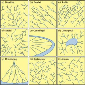
A dendritic drainage pattern resembles the branches of a tree, with many.. more →
D

Deposition 

Deposition is the geological process by which sediments, soil, and rocks are.. more →
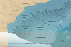
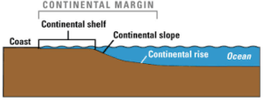
Diagram showing continental margin and ocean features

CContinental Margin

The continental margin is the zone of the ocean floor that separates the thin oceanic crust from the thick continental crust. It includes the continental shelf, continental slope, and continental rise. Continental margins are key areas for studying sediment deposition, tectonic activity, and the interaction between land and ocean systems. They are also important for oil and gas exploration. 

Reference: Carter, L., Carter, R. M., & McCave, I. N. (2004). “Evolution of the Sedimentary System on the Pacific Margin of Eastern New Zealand.” Marine Geology, 205(1-4), 9-27. 
Share 

Open entry →
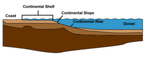
Diagram of continental shelf, slope, and rise underwater

CContinental Shelf

The continental shelf is the submerged, gently sloping edge of a continental landmass that extends from the shoreline to the continental slope. This area is rich in marine life and resources, including oil and gas deposits. The continental shelf is crucial in the study of marine geology, oceanography, and the exploration of natural resources. 

Reference: Shepard, F. P. (1973). Submarine Geology. Harper & Row. 

Share 

Open entry →
Diagram of continental slope and ocean floor features

CContinental Slope

The continental slope is the steeply inclined section of the continental margin that descends from the edge of the continental shelf to the continental rise. It marks the true edge of the continent, where the continental crust transitions to the oceanic crust. The study of continental slopes is crucial for understanding sediment transport, submarine landslides, and the dynamics of ocean currents. 

Reference: Menard, H. W. (1964). Marine Geology of the Pacific. McGraw-Hill.

Share 

Open entry →
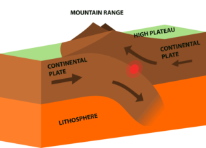
Continental plates forming mountain range diagram (convergent boundary)

CConvergent Boundary

A convergent boundary is a type of tectonic plate boundary where two plates move toward each other. At these boundaries, one plate is usually forced beneath the other in a process known as subduction. Convergent boundaries are associated with the formation of mountain ranges, deep ocean trenches, and volcanic activity. They are critical in understanding the processes of orogeny, subduction, and the recycling of oceanic crust into the mantle. 

Reference: Stern, R. J. (2002). “Subduction Zones.” Reviews of Geophysics, 40(4), 1012. 

Share 

Open entry →
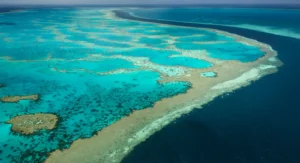
Aerial view of vibrant coral reef and ocean (coral reef)

CCoral Reef

Coral reefs are marine ecosystems composed of reef-building corals, which are colonies of small, sessile animals known as polyps. These reefs are found in shallow, warm ocean waters and are vital for biodiversity, providing habitat for a vast array of marine life. Coral reefs are also important in the study of marine biology, ecology, and climate change, as they are sensitive indicators of environmental stress. 

Reference: Spalding, M. D., Ravilious, C., & Green, E. P. (2001). World Atlas of Coral Reefs. University of California Press. 

Share 

Open entry →
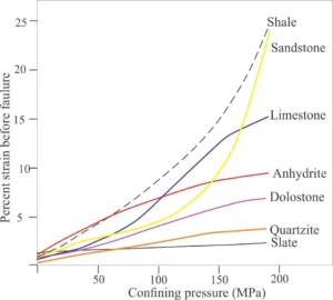
Rock strain versus confining pressure comparison graph (Coulomb's Law)

CCoulomb’s Law

In geology, Coulomb’s law refers to a criterion used to describe the conditions under which a material will fail due to shear stress. It is based on the relationship between the shear stress and normal stress on a plane, along with the material’s internal friction and cohesion. This law is fundamental in understanding fault mechanics, rock stability, and landslide processes. 

Reference: Jaeger, J. C., Cook, N. G. W., & Zimmerman, R. (2007). Fundamentals of Rock Mechanics. Wiley-Blackwell. 

Share 

Open entry →
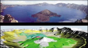
Crater lake and 3D volcanic caldera model

CCrater Lake

A crater lake is a body of water that occupies a volcanic crater or caldera. These lakes can form in the depressions left by volcanic eruptions, meteorite impacts, or explosions. Crater lakes are often used in the study of volcanic activity, geochemistry, and hydrology, as they can provide insights into the volcanic history and ongoing processes in the region. 

Reference: Bacon, C. R., & Lanphere, M. A. (2006). “Eruptive History and Geochronology of Mount Mazama and the Crater Lake Region, Oregon.” Geological Society of America Bulletin, 118(11-12), 1331-1359. 

Share 

Open entry →
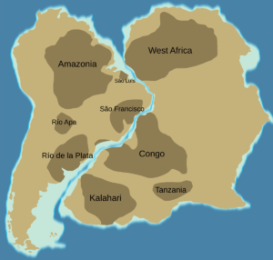
Map showing South America and Africa alignment (craton)

CCraton

A craton is a large, stable block of the Earth’s crust that forms the ancient, central core of a continent. Cratons are composed of Precambrian rocks that have remained relatively undisturbed by tectonic activity for billions of years. They are significant in the study of geology as they represent the oldest and most stable parts of the Earth’s lithosphere, providing insights into the early history of the planet. 

Reference: Bleeker, W. (2003). “The Late Archean Record: A Puzzle in ca. 35 Pieces.” Lithos, 71(2-4), 99-134. 

Share 

Open entry →
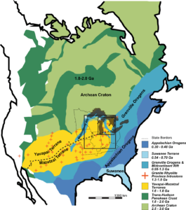
Geological map of North American continental formations (cratonic basin)

CCratonic Basin 

A cratonic basin is a large, stable sedimentary basin that forms on a craton, the ancient, stable core of a continent. These basins are typically characterized by long periods of subsidence, leading to the accumulation of thick sedimentary sequences. Cratonic basins are significant for studying the history of sedimentation, tectonics, and natural resource deposits, including oil and gas. 

Reference: Sloss, L. L. (1963). “Sequences in the Cratonic Interior of North America.” Geological Society of America Bulletin, 74(2), 93-114. 

Share 

Open entry →
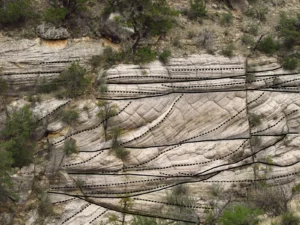
Sedimentary rock layers with structural lines and vegetation (cross bedding)

CCross-Bedding 

Cross-bedding is a sedimentary structure characterized by inclined layers within a horizontal bed, formed by the movement of sediment by wind or water. These structures are commonly found in environments like rivers, deltas, and deserts. Cross-bedding is important for interpreting past flow conditions, sediment transport, and the depositional environment in which the sediment was laid down. 

Reference: Allen, J. R. L. (1982). Sedimentary Structures: Their Character and Physical Basis. Elsevier. 

Share 

Open entry →
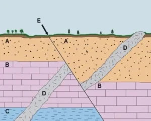
Geologic cross section showing rock layers and fault line (Cross-Cutting Relationships)

CCross-Cutting Relationships

Cross-cutting relationships are a principle of geology that states that any geological feature that cuts across another is younger than the feature it cuts. This principle is fundamental in establishing the relative ages of rocks and geological structures, and is widely used in stratigraphy, tectonics, and the interpretation of geological history. 

Reference: Ramsay, J. G., & Huber, M. I. (1987). The Techniques of Modern Structural Geology, Volume 2: Folds and Fractures. Academic Press. 

Share 

Open entry →
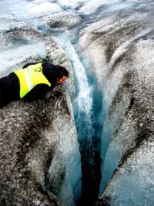
Person observing deep crevasse with flowing glacier water (Cryoconite)

CCryoconite

Cryoconite is a dark, granular material found on glacier surfaces, composed of dust, soot, and other fine debris, often mixed with microbial communities. It absorbs solar radiation, leading to localized melting of the ice and the formation of small depressions called cryoconite holes. Cryoconite is important in the study of glacial environments, as it influences the albedo and melting rates of glaciers. 

Reference: Hodson, A. J., Anesio, A. M., Ng, F., Watson, R., Quirk, J., Irvine-Fynn, T., & Sattler, B. (2007). “A Glacier Respires: Quantifying the Distribution and Respiration of Cryoconite Across an Entire Arctic Supraglacial Ecosystem.” Journal of Geophysical Research: Biogeosciences, 112(G4). 

Share 

Open entry →
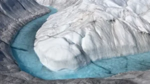
Bright blue meltwater river flowing through glacier ice (cryosphere)

CCryosphere

The cryosphere encompasses all the Earth’s frozen water, including glaciers, ice caps, ice sheets, sea ice, snow, and permafrost. The cryosphere plays a critical role in regulating the Earth’s climate by reflecting solar radiation and influencing sea levels. Understanding the cryosphere is essential for studying climate change, hydrology, and global sea-level rise. 

Reference: IPCC (2019). The Ocean and Cryosphere in a Changing Climate. Intergovernmental Panel on Climate Change Special Report.

Share 

Open entry →
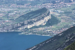
Mountain ridge overlooking lake and town below (cuesta)

CCuesta

A cuesta is a ridge with a gentle slope on one side and a steep slope on the other, typically formed by the differential erosion of tilted sedimentary rock layers. The gentle slope corresponds to the dip of the strata, while the steep slope is the scarp face. Cuestas are common in areas of gently folded sedimentary rocks and are important in understanding the processes of erosion and landscape development. 

Reference: Baker, V. R., & Twidale, C. R. (1991). “The Elucidation of Landform Assemblages and Their Genesis.” Geological Society of America Bulletin, 103(9), 1166-1177. 

Share 

Open entry →
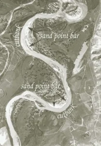
Aerial view of meandering river with sand point bars (cut bank)

CCut Bank

A cut bank is the outside bank of a meander in a river, where erosion is actively occurring due to the higher velocity of water flow. Cut banks are important features in the study of fluvial geomorphology and river dynamics, as they contribute to the lateral migration of rivers and the formation of meandering channels. 

Reference: Leopold, L. B., Wolman, M. G., & Miller, J. P. (1964). Fluvial Processes in Geomorphology. Dover Publications. 

Share 

Open entry →
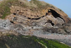
Layered coastal rock formation with grass on top (cyclothem)

CCyclothem

A cyclothem is a repeating sequence of sedimentary rock layers that represents alternating marine and non-marine conditions, typically associated with the cyclic rise and fall of sea levels. Cyclothems are important in the study of stratigraphy and sedimentology, particularly in understanding the depositional environments of coal-bearing sequences. 

Reference: Heckel, P. H. (1986). “Sea-Level Curve for Pennsylvanian Eustatic Marine Transgressive-Regressive Depositional Cycles along Midcontinent Outcrop Belt, North America.” Geology, 14(4), 330-334. 

Share 

Open entry →
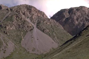
Rocky mountain slope with loose scree deposits (debris cone)

DDebris Cone

A debris cone is a conical accumulation of rock fragments, soil, and other debris that has been transported downslope by gravity, water, or ice. These cones often form at the base of cliffs, slopes, or glaciers and are important for understanding mass-wasting processes, sediment transport, and the geomorphology of mountainous regions. 

Reference: Whalley, W. B., & Azizi, F. (2003). “Rock Glaciers and Protalus Forms: Analogous Forms and Equifinal Processes?” Geografiska Annaler: Series A, Physical Geography, 85(3-4), 237-249. 

Share 

Open entry →
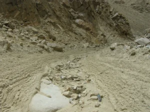
Rocky desert mountain trail with tire tracks (debris flow)

DDebris Flow

A debris flow is a fast-moving mass of loose mud, sand, soil, rock, and water that flows down a slope, typically triggered by heavy rainfall, volcanic activity, or rapid snowmelt. Debris flows are highly destructive and pose significant hazards in mountainous regions. They are important in the study of mass wasting, geomorphology, and natural hazards. 

Reference: Iverson, R. M. (1997). “The Physics of Debris Flows.” Reviews of Geophysics, 35(3), 245-296.

Share 

Open entry →
Mid-ocean ridge magma formation and seafloor spreading diagram (decompression melting)

DDecompression Melting

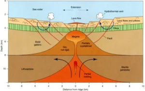
Decompression melting occurs when a body of rock ascends in the Earth’s mantle, leading to a decrease in pressure while the temperature remains nearly constant, allowing the rock to melt. This process is significant in the formation of mid-ocean ridge basalts, hotspot volcanism, and continental rift zones, contributing to the generation of new crust. 

Reference: McKenzie, D., & Bickle, M. J. (1988). “The Volume and Composition of Melt Generated by Extension of the Lithosphere.” Journal of Petrology, 29(3), 625-679. 

Share 

Open entry →
Folded metamorphic rock marked with colored lines (deformation)

DDeformation

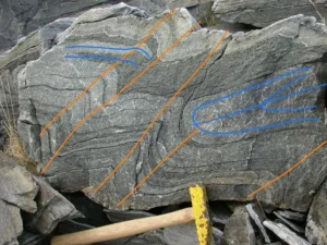
Deformation refers to the alteration of the shape or volume of a rock body in response to stress, including processes like folding, faulting, and fracturing. Deformation is a key concept in structural geology and tectonics, helping to explain the formation of mountains, earthquakes, and other geological structures. 

Reference: Twiss, R. J., & Moores, E. M. (2007). “Structural Geology.” W. H. Freeman.

Share 

Open entry →
Rock layers showing visible fault line and coin scale (deformation bands)

DDeformation Bands

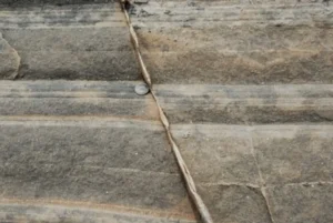
Deformation bands are narrow zones of localized strain in porous rocks, often associated with faulting and folding. These bands can form due to mechanical compaction, cataclasis, or grain reorganization and can significantly influence the permeability and mechanical properties of the rock. Deformation bands are important in the study of structural geology, fault mechanics, and reservoir characterization. 

Reference: Aydin, A., & Johnson, A. M. (1983). “Analysis of Faults and Deformation Bands in Sandstone.” Journal of Structural Geology, 5(1), 19-31.

Share 

Open entry →
Satellite view of a vibrant river delta

DDelta

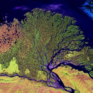
A delta is a landform formed at the mouth of a river, where it deposits sediment as it flows into a slower-moving or standing body of water, such as an ocean, sea, or lake. Deltas are characterized by their branching network of distributaries and are classified based on the dominant processes that shape them: river-dominated, wave-dominated, or tide-dominated. Deltas are significant in sedimentology, coastal geomorphology, and are often fertile areas for agriculture. 

Reference: Coleman, J. M., & Wright, L. D. (1975). “Deltas: Processes of Deposition and Models for Exploration.” Continuing Education Publishing Co. 

Share 

Open entry →
Different types of river dendritic drainage patterns diagram.

DDendritic Drainage Pattern

A dendritic drainage pattern resembles the branches of a tree, with many small tributaries joining together to form larger streams and rivers. This pattern develops in regions of relatively uniform rock or soil, where the underlying material does not strongly influence the direction of stream flow. Dendritic patterns are significant in geomorphology for interpreting the characteristics of the underlying substrate and landscape evolution. 

Reference: Howard, A. D. (1994). “A Detachment-Limited Model of Drainage Basin Evolution.” Water Resources Research, 30(7), 2261-2285. 

Share 

Open entry →

DDeposition 

Deposition is the geological process by which sediments, soil, and rocks are added to a landform or landmass. This occurs when the forces transporting the particles, such as water, wind, or ice, lose energy and drop the material. Deposition is fundamental in the formation of sedimentary rocks, the creation of landforms like deltas and beaches, and the development of stratigraphic layers. 

Reference: Boggs, S. (2011). “Principles of Sedimentology and Stratigraphy.” Pearson. 

Share 

Open entry →

join.me

Geology made clear, in your inbox.

Get clear, visual explainers on rocks, minerals, deep time, and the most fascinating parts of Earth science from Geoscopy.
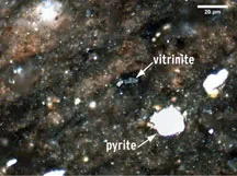
Microscopic view showing vitrinites and pyrite minerals.

VArchives: Glossary

Vitrinite is a type of maceral (organic component of coal) derived from woody plant material. It is significant in coal geology and organic petrology for understanding the rank (degree of metamorphism) of coal, its carbon content, and the thermal maturity of hydrocarbon source rocks. 

Reference: Taylor, G. H., et al. (1998). “Organic Petrology.” Gebrüder Borntraeger. 

Share 

Open entry →