


The Messinian Salinity Crisis and the Zanclean Megaflood
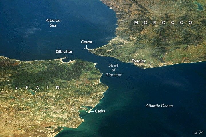
The breach began near the present Strait of Gibraltar as a slow leak of Atlantic water across a sill that tectonics and erosion had brought close to failure. The slow phase may have lasted up to several thousand years. Once erosion cut the channel below a critical depth, discharge accelerated, the channel cut deeper, and the system entered a runaway in which roughly ninety per cent of the transferred water moved through in a window between a few months and two years. Peak discharge reached about 100 million cubic metres per second, three orders of magnitude larger than the modern Amazon, through a channel 200 kilometres long and at least 250 metres deep. The receiving basin lay between two and four kilometres below the level of the world ocean, its floor dry and salt-crusted, with canyons cut into its margins by rivers that had been adjusting to a falling base level for several hundred thousand years. The sea behind that wall rose by as much as ten metres a day. This is the geological event known as the Zanclean megaflood, and it is the closing scene of the Messinian Salinity Crisis: the episode, between roughly 5.97 and 5.33 million years ago, in which the Mediterranean was transformed from an open marine basin into a restricted, evaporating system that ultimately precipitated about one million cubic kilometres of salt.
When the desiccation hypothesis was first proposed in the early 1970s, most marine geologists rejected it. The evidence is now routine: a salt layer averaging around 1.5 kilometres thick across the deep Mediterranean basins, locally exceeding two; canyons of the Nile and Rhône cut to vertiginous depths beneath their modern courses; gypsum in shallow workable seams from Cyprus to Sorbas; halite mined today, near Agrigento, from beds that precipitated from a nearly evaporated sea. What remains contested is almost everything else: how dry the basin really got, whether tectonics or climate did the closing, and exactly how the refill played out.
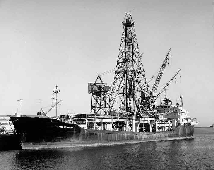
1970: Glomar Challenger and the discovery of deep-sea evaporites
In August 1970, the drillship Glomar Challenger sailed into the Mediterranean on Leg 13 of the Deep Sea Drilling Project. The chief scientists were Kenneth J. Hsü of ETH Zürich and William B. F. Ryan of the Lamont-Doherty Geological Observatory; the shipboard micropaleontologist was Maria B. Cita, of the Università di Milano, who had already been one of the first two women to sail on Glomar Challenger. They were drilling through Pliocene oozes when their cores began to come up wrong. From beneath the soft pelagic carbonates the bit kept biting into laminated gypsum, anhydrite, and rock salt; minerals that form when seawater evaporates, not when it sinks slowly to a deep, quiet floor.
The first paper, written quickly and published in Nature in March 1973, was titled simply “Late Miocene desiccation of the Mediterranean.” In it, Hsü, Ryan and Cita argued that the evaporite layer beneath the abyssal plains could be explained only one way: the Mediterranean had repeatedly dried down to a hot, hypersaline sump, perhaps several kilometres below the level of the world ocean, and seawater had been re-admitted only intermittently to keep the salt accumulating. The idea ran into a wall of disbelief. Deep basins do not dry up. They contain too much water; the heat balance was wrong; the inferred sea-level drop on the Mediterranean side, of order one to two kilometres, looked physically extravagant. For more than a decade, alternative models, “shallow water, deep basin” compromises in which the salt formed in marginal lagoons before subsiding, held considerable ground. The controversy drained away under the convergent weight of evidence from land outcrops, seismic profiles, and the geometry of buried river canyons that no amount of marginal lagoonal precipitation could explain.
Hsü’s 1983 memoir The Mediterranean Was a Desert (Princeton University Press) documents the gradual acceptance of the desiccation hypothesis through the late 1970s and early 1980s. By the time of the CIESM consensus monograph in 2008 and the synoptic review by Roveri and colleagues in Marine Geology in 2014, desiccation had become the working framework even for those who disagreed on details.
Tectonic setting: the Atlantic–Mediterranean gateways in the late Miocene
To grasp what happened in the late Miocene, it helps to remember that the Mediterranean is a remnant. It is what is left of Tethys, the great equatorial ocean that once separated Laurasia from Gondwana, after Africa and Arabia rotated north and welded themselves to Eurasia in a series of orogenies that built the Atlas, the Betics, the Apennines, the Hellenides and the Taurides. By the Tortonian, around eight million years ago, the Tethyan connection eastward was already gone. Atlantic water reached the Mediterranean through two corridors: the Betic Strait through what is now southern Spain, and the Rifian Corridor through northern Morocco. The modern Strait of Gibraltar, narrower than either of its predecessors, did not yet exist as a marine throughway.
The convergence between Africa (Nubia) and Iberia is slow but persistent. Plate-scale Nubia–Eurasia motion in the western Mediterranean runs at roughly 4–5 mm/yr, but only a fraction of this — around 2 mm/yr in the Alboran region, with present-day rates across the Gibraltar Arc of 1.7–3.0 mm/yr (Galindo-Zaldivar et al., 2022), is actually accommodated at the Strait itself. The Betic and Rifian gateways narrowed through the late Miocene as the Gibraltar Arc rolled westward and uplifted. Wout Krijgsman and colleagues, working on the Taza-Guercif basin in Morocco and on cyclic sapropels in Italy and Spain, dated the closure of the last Atlantic connection with astronomical precision in their landmark 1999 Nature paper. The onset of evaporite deposition across the Mediterranean is locked to 5.97 ± 0.02 million years ago. The end, when normal marine conditions abruptly resume in the Zanclean stratotype at Eraclea Minoa on Sicily, is 5.33 million years ago. Within those 640,000 years the Mediterranean became something the planet has not produced since: a basin-sized evaporator the size of a continental sea.
Tectonics almost certainly restricted the inflow first. The killing blow, what severed the Atlantic feed entirely, has never been settled. The 2011 Nature paper by Daniel García-Castellanos and Antonio Villaseñor, modelling the Gibraltar Arc as a balance between rising rock and downcutting water, argued that the system can perch on a knife-edge: tectonic uplift narrows the seaway and chokes inflow, but accelerating outflow erodes the sill back open, sometimes catastrophically. Glacioeustatic forcing, in turn, came from the south. Ohneiser and colleagues, working with Antarctic sedimentary records, showed that the Antarctic ice sheet expanded at almost exactly the right time, dropping global sea level by tens of metres around 6 Ma: a pull that, applied to a tectonically choked seaway, was probably enough to finish the job.
The evaporite sequence: from carbonate to halite to potash
The chemistry of an evaporating marine basin is straightforward. Calcium carbonate precipitates first, then calcium sulfate, then sodium chloride, then the bittern salts of potassium and magnesium. Concentrating a finite volume of seawater by evaporation produces a layered sequence: dolomitic carbonate at the base, gypsum, halite, and, only at concentrations of roughly sixty times normal salinity, kainite, carnallite, and other potash minerals that mark near-total desiccation.
The Mediterranean made the whole sequence. The Roveri et al. (2014) synthesis describes it across three stages. Stage 1, from 5.97 to about 5.60 Ma, deposited the Primary Lower Gypsum: up to sixteen precessionally driven cycles of selenite-marl couplets, beautifully exposed today in the Vena del Gesso badlands of the northern Apennines, in the Yesares Formation at Sorbas in Andalusia, and in the Gessoso-Solfifera of Sicily. These gypsum cycles formed in marginal sub-basins less than two hundred metres deep, while the central Mediterranean accumulated organic-rich, oxygen-depleted shales. Stage 2, only fifty thousand years long between roughly 5.60 and 5.55 Ma, is the acme: the so-called Mediterranean Salt Giant. Stage 3, from 5.55 to 5.33 Ma, is the Upper Gypsum and the brackish Lago Mare deposits that fill the basin at the very end.
The size of the salt giant is the figure most often misquoted. The number that has stuck in the literature, from Hsü’s original DSDP synthesis and confirmed by every subsequent compilation including the CIESM monograph and the recent Krijgsman et al. (2024) review in Nature Reviews Earth & Environment, is roughly one million cubic kilometres of salt, about five per cent of the salt currently dissolved in the world ocean. The MEDSALT COST Action and the SALTGIANT training network describe a single layer averaging around 1.5 km thick across the deep Mediterranean basins, locally exceeding two kilometres. Manzi et al. and Lugli et al., working in the Realmonte salt mine on Sicily, one of the few places where the deep-basin halite is accessible to a geologist on foot, measure four hundred to six hundred metres of layered salt, divided into four lithological units, including kainite layers eighteen metres thick. The polygonal contraction cracks they describe in the upper salt are the kind of features you find on the floors of modern playas. They imply, at least locally, that even the central deep basin was occasionally exposed.
The salt itself: outcrops at Realmonte and Sorbas, and the deep-basin record
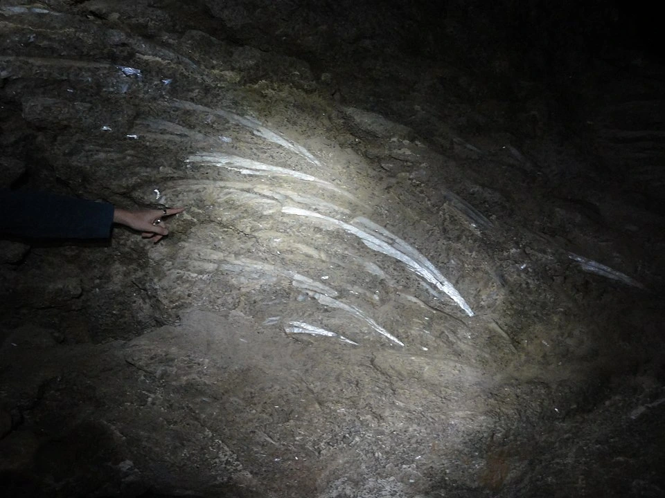
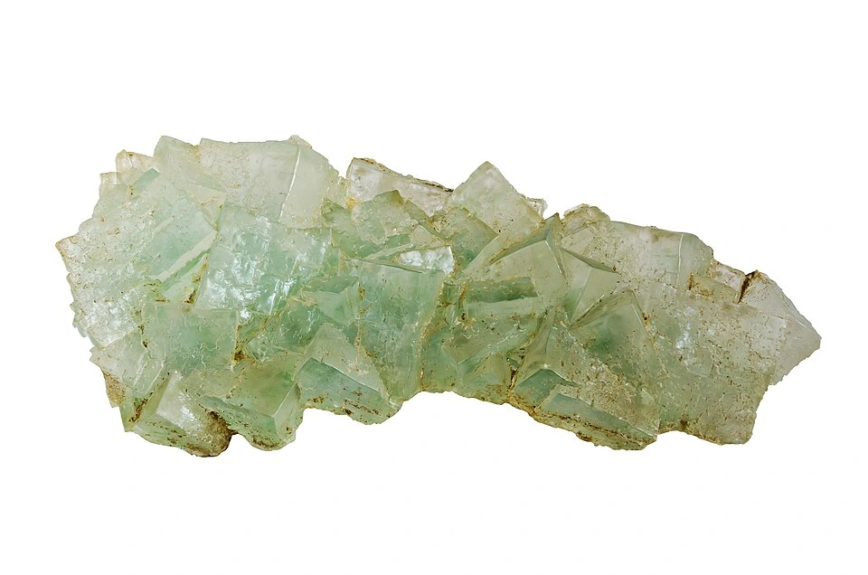
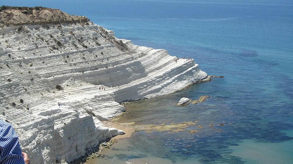
The Realmonte salt mine, at Contrada Scavuzzo near Agrigento on Sicily’s southern coast, is the most accessible exposure of the deep-basin Messinian halite. The walls are pale halite banded white and grey on annual evaporation cycles, interleaved with kainite: the potassium-magnesium sulfate that requires the most extreme concentration of seawater. The mine’s 130 kilometres of tunnels run from +60 to −252 m elevation, and a small chapel cut into the salt at depth is dedicated to Saint Barbara, patron of mineworkers. The salt itself, dated by Manzi and colleagues to between 5.60 and 5.55 Ma, accumulated within fifty thousand years. Inside the crystals, fluid inclusions preserve drops of the brine that formed them.
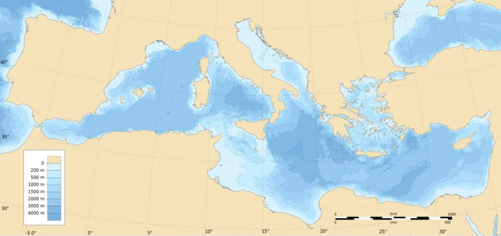
The geographic spread of the deposits is what ultimately decided the desiccation argument. Gypsum of Messinian age outcrops in coherent stratigraphic units across more than a thousand kilometres: at Sorbas in southeastern Spain, in the Vena del Gesso of Romagna, across central Sicily, in the Pissouri basin of Cyprus, in fragments on Crete and Zakynthos. Beneath the abyssal plains, seismic reflection profiles see the salt as a strong, continuous reflector, the so-called M reflector, capped by the unconformity that DSDP cores recovered from below. Wherever drill bits or oil-industry boreholes have penetrated to it, the bedded halite is there. Salt giants of comparable scale are rare in the geological record: the Permian Zechstein, the Aptian South Atlantic, a handful of older examples. The Messinian is the youngest and the only one whose tectonic and oceanographic boundary conditions are still recognisable in the modern landscape.
Just how dry the basin actually got is still being argued. Aloisi et al. (2024), analysing chlorine isotopes in halite, identified two phases of salt accumulation. In the first (~35 kyr), salt deposited only in the eastern Mediterranean from a brine-filled basin still connected to the Atlantic. In the second, a rapid (<10 kyr) evaporative drawdown lowered sea level by 1.7–2.1 km in the eastern basin and by ~0.85 km in the west. García-Castellanos et al. (2025, Science Advances) used a landscape-evolution model to show that erosional capture of surrounding lake systems, particularly the Paratethys, drained progressively through the Bosphorus, Aegean, and Iron Gate, fed water into the Mediterranean throughout stage 3, modulated by orbital climate forcing. Their reconstruction is a sea-level history with kilometric oscillations, not a single steady drawdown, and accounts for the brackish Lago Mare faunas without requiring direct marine inflow. Earlier modelling work by Meijer and Krijgsman (2005) had already suggested that even a fully isolated Mediterranean would dry to roughly a kilometre and a half below global sea level before evaporation came into balance with the small freshwater input from rivers and rain. The literature genuinely disagrees on the maximum depth of the drawdown, proposals span from a few hundred metres to nearly three kilometres, and that disagreement is the principal reason the IODP/IMMAGE drilling programme, which sent the JOIDES Resolution into the Gulf of Cádiz and the Alborán Sea on Expedition 401 in 2023–2024, exists at all.
The Lago Mare phase and the rivers of an exposed basin
The desiccated Mediterranean was not lifeless. The Lago Mare phase, in the final two hundred thousand years of the crisis, left brackish and lacustrine sediments stretching from the Po basin to Cyprus, with mollusc faunas of pronounced Paratethyan affinity — ostracods and cardiid bivalves whose closest relatives lived in the proto-Caspian to the northeast. Andreetto et al. (2021) reviewed the Lago Mare evidence in detail. Water sat in many of the deeper sub-basins for much of stage 3, often fresher than normal seawater, fed by rivers from Europe and intermittently by spillover from the Paratethys system through corridors whose geography remains unresolved. The eastern and western Mediterranean were probably separated for long stretches by the emergent Sicily sill, and chemistry on either side evolved independently.
Where the seafloor was exposed, the rivers responded. With base level dropped by a kilometre or more, every stream draining into the basin entrenched. The Rhône cut a gorge beneath what is now Provence, identified in well logs from below the Camargue and traced upstream into Lyon; its Pliocene infill is up to a kilometre deep. The Nile incised a canyon now buried beneath Cairo, recognised from the early oil exploration of the Nile delta; its bedrock floor lies more than two thousand metres below modern sea level. The Var, the Ebro, the Po, smaller rivers in Greece and Anatolia all carved Messinian-age gorges that the seismic stratigraphers of the offshore industry know well, because petroleum reservoirs accumulate in their fills. García-Castellanos and colleagues used these canyons as the most direct geomorphic evidence that base level on the Mediterranean side had to fall by 2,500 m or more during the crisis. The canyons are erosional, not depositional. They demand a low standing water surface, sustained for hundreds of thousands of years.
Across the exposed margins, mammalian faunas exchanged. The Messinian record shows mammalian exchanges across previously marine corridors, including faunal mixing between North Africa and Iberia. The deep genetic structure of Mediterranean seagrasses across the Strait of Sicily and the phylogeography of Podarcis wall lizards between Iberia and North Africa preserve signatures of a sea that briefly stopped being a barrier.
What closed the gateways: tectonic and glacioeustatic forcing
Two mechanisms have been proposed and probably acted together: tectonic restriction of the gateways and glacioeustatic sea-level fall.
The tectonic case is straightforward. The Africa–Iberia plate boundary was, and is, converging at four to five millimetres per year. The Betic and Rifian corridors, which carried Atlantic water in the Tortonian, narrowed steadily through the late Miocene as the Gibraltar Arc rolled west and the Alboran block uplifted. Krijgsman’s field work in the Taza-Guercif basin showed the Rifian Corridor closed first, around 6.7 to 6.0 Ma, in stages tied to specific marine to continental transitions. Govers (2009) modelled the system as a slow “choking,” with the salinity crisis triggered when the threshold for blocking deep outflow was crossed. The Booth-Rea, Ranero and Grevemeyer paper in Scientific Reports (2018) added a less expected actor: a late Miocene volcanic arc in the eastern Alboran basin, built in part by slab rollback, that sat directly across the Atlantic inflow path and may have functioned as a topographic dam.
The climatic case is equally well evidenced. Ohneiser and colleagues (2015) extracted, from Antarctic sedimentary cores, a sharp expansion of the East Antarctic ice sheet at almost exactly 6 Ma. That expansion sucked tens of metres of water out of the world ocean. The associated relative sea-level fall at the Strait of Gibraltar, in their model, lasted about fifty thousand years and was coupled to lithospheric flexure as evaporite mass piled up on the floor of the basin. Whether this glacioeustatic pulse closed the gateway on its own is doubtful, but combined with progressive tectonic shoaling, it has the shape of a trigger.
The 2011 García-Castellanos and Villaseñor model, treating uplift and erosion as competing terms in the same equation, may turn out to be the right framework. In their numerical experiments, the system can persist for hundreds of thousands of years near the threshold of closure, with relatively small perturbations in either uplift rate or sea level pushing it across. That picture matches the cyclicity Krijgsman documents in the evaporite record and matches the abruptness of the eventual termination.
The Zanclean megaflood: 200-km channel and the 2009 incision model
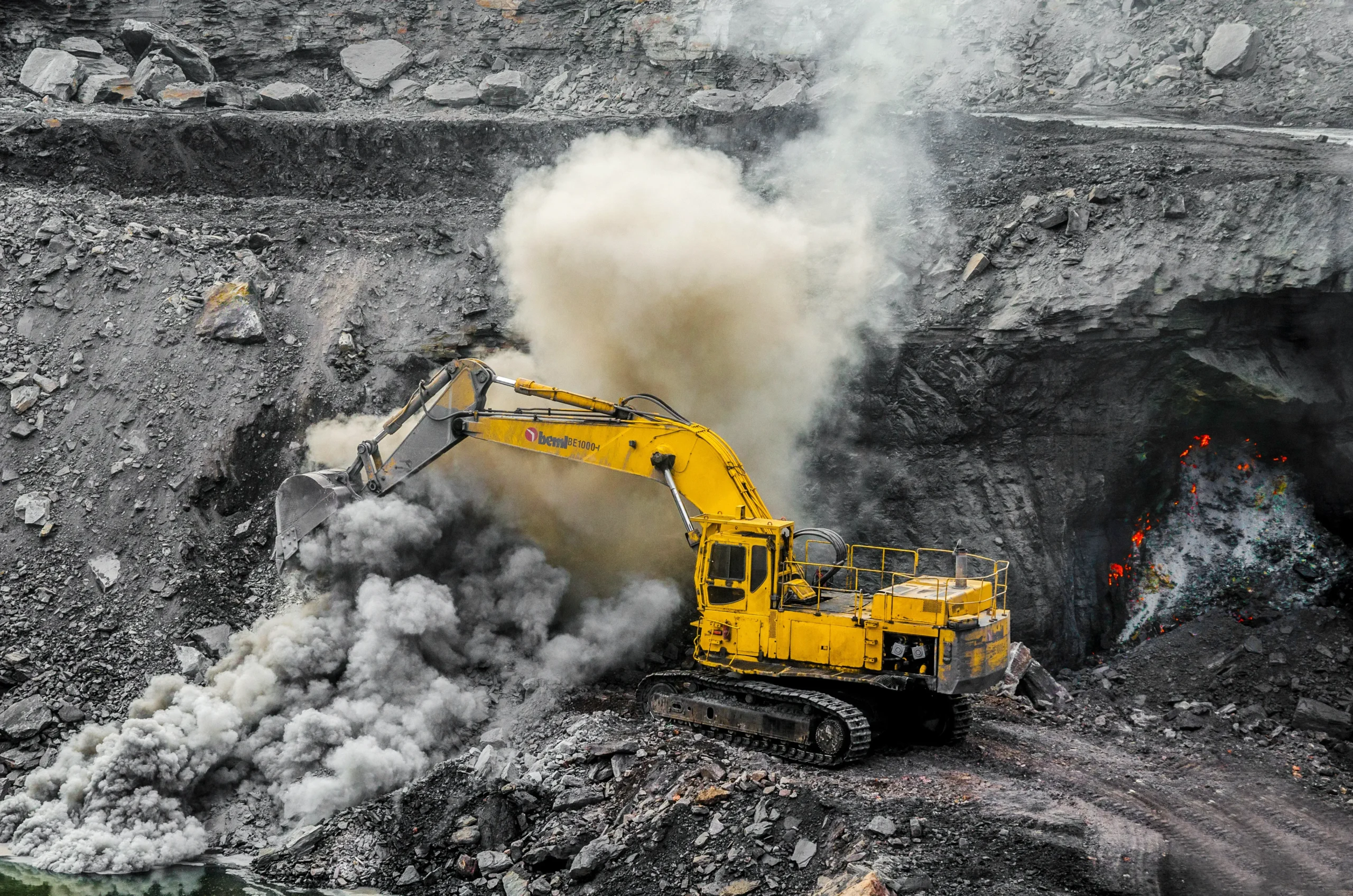
The flood that ended the crisis, when it came, did not announce itself with a wall of water. García-Castellanos et al. (2009, Nature) reframed an erosional channel known from offshore industry seismic: 200 km long, incised more than 250 m into Miocene basement, continuous from the Gulf of Cádiz across the Strait into the Alborán Sea. Earlier interpretations had read it as fluvial: a river system cut during desiccation when Mediterranean base level stood far below the Atlantic. The 2009 paper showed the geometry is incompatible with a river. The cross-section is U-shaped, the channel widens and deepens eastward, and it crosses topographic highs no draining river would cross. The geometry matches a flood.
It fits a flood. Adopting an incision model from mountain rivers, parameterised against bedrock erodibility values from independent studies, they ran the geometry backwards. The reference solution converged on a flood in which roughly ninety per cent of the water transferred in a window between several months and two years. Peak discharge reached roughly 100 million cubic metres per second. Sea level in the Mediterranean rose at rates of more than ten metres per day. The flood eroded the Camarinal Sill and the wider strait by hundreds of metres, with retrogressive headcutting that propagated up to eighty kilometres west into the Atlantic margin. To get a sense of scale: at peak discharge the Zanclean flood was carrying about a thousand times the modern Amazon, or roughly a hundred times the highest estimated discharge of the Missoula glacial outburst floods that scoured the Channelled Scablands of eastern Washington.
The model has been tested against independent evidence. Estrada et al. (2011) found pulsed Atlantic water inflow signatures in Alborán basin contourites. Micallef and colleagues (2018), using high-resolution seismic and bathymetric data from the eastern Mediterranean, identified a chaotic, seismically transparent wedge up to 860 m thick at the foot of the Malta Escarpment — the deposit of the flood waters as they spilled from the western Mediterranean over the Sicily sill into the Ionian basin. Spatola et al. (2020) extended the case for a single catastrophic flood with geophysical evidence from the same eastern basin.
Where there is genuine disagreement, it concerns timescale and abruptness. Abril and Periáñez (2016) ran computational fluid dynamics simulations and obtained refill durations of years to decades, depending on assumed sill geometry — slower than the García-Castellanos minimum but still much faster than any Holocene analogue. The 2020 García-Castellanos et al. review in Earth-Science Reviews reconciled most of the published work into a single-stage flood with a multi-month main pulse, but the “months” end of the range remains a model preference rather than a measured fact. The most recent García-Castellanos et al. (2025) Science Advances paper complicates the picture further by suggesting the sea-level fall through stage 3 was itself oscillatory, so the surface the flood encountered was not a uniformly dry basin floor but a partially water-filled hypersaline lake system at varying depths.
The Zanclean reflooding: oxygenation, biology, and the Pliocene boundary
When its discharge tapered, the flood had produced a Mediterranean once again connected to the Atlantic, with a Strait of Gibraltar narrower and deeper than its predecessors and a sea floor blanketed in salt. The Pliocene Zanclean stage takes its name from Zancle, the ancient Greek name for Messina, and its global stratotype is at Eraclea Minoa on Sicily, where pale Trubi marls — open-marine planktonic foraminiferal oozes — sit directly on Messinian gypsum across a sharp, clean contact. The biostratigraphic shift across that surface is one of the most abrupt in the Cenozoic record. Within a few centimetres, evaporite-impoverished Lago Mare ostracods give way to a fully Atlantic foraminiferal fauna.
Amarathunga et al. (2025, PNAS), using lipid biomarkers and redox proxies in cores, showed that the Mediterranean was transiently oxygenated immediately after the Zanclean refilling, as cold, dense Atlantic water flushed a basin that had been stratified and anoxic. The biological recovery, however, was incomplete. The modern Mediterranean is impoverished relative to the Atlantic, with about half the species richness one would expect from area alone, and an east–west diversity gradient that traces, ultimately, to the bottleneck of the Zanclean reflooding. Many endemic late Miocene Mediterranean fish, seagrasses and benthic invertebrate lineages did not survive the crisis and were replaced from the Atlantic gene pool when the gates reopened. Modern phylogeographic studies of Mediterranean organisms are consistent with that post-crisis reset, although later Pleistocene climate cycles and present-day circulation also shaped the patterns we see now.
The salt itself stayed put. Buried beneath younger sediment, it has done what salt does — it has flowed. Salt diapirs rise off the floor of the Levantine basin south of Cyprus, off the Algerian margin, off Provence and the Balearic margin. They form traps for hydrocarbons, hazards for deep drilling. In recent literature they also turn up as habitats for chemosynthetic microbial communities living in deep brine pools fed by halite dissolution. The European hydrocarbon industry has a very practical interest in the Mediterranean Salt Giant: substantial Plio-Pleistocene gas and oil accumulations sit above and beside it, and the geometry of any potential reservoir depends on understanding how the underlying salt has deformed since the Zanclean. The MEDSALT COST Action, which ran from 2016 to 2020, and the Marie Skłodowska-Curie SALTGIANT training network that succeeded it, were established in part to coordinate the academic and industrial science around this salt body. IODP Expedition 401, in 2023–2024, drilled the Atlantic margin record on either side of Gibraltar; the post-cruise Expedition 402 and the planned ICDP onshore drilling in southern Spain and Morocco aim to bracket the gateway from both directions for the first time.
The Messinian Erosion Surface and the modern Mediterranean
5.3 million years after the Zanclean refilling, the Messinian crisis remains visible in the modern basin. The Mediterranean is anomalously saline by ocean standards — about 38 grams per litre against the Atlantic’s 35 — because evaporation continues to exceed runoff and only the narrow Gibraltar exchange replenishes it. The seafloor topography still preserves the buried Messinian Erosion Surface as a regionally mappable horizon: a ragged unconformity carved when the basin lay dry. The Nile, the Rhône, the Var and the Po all finished filling their Messinian gorges only in the Quaternary; the soft Pliocene infill is locally responsible for ground-stability problems at Cairo and Marseille. The salt giant itself, despite five million years of subsidence and burial, is not yet wholly tectonically mature: it continues to flow on geological time scales, generating slow seafloor deformation that is detectable in modern bathymetric resurveys.
The crisis also left a marker on the global ocean. Removing about five per cent of the dissolved salt of the world ocean, even temporarily, changes seawater density. Topper, Trabucho-Alexandre, Tuenter and Meijer (2011) modelled the ocean response and concluded that the salt extraction would have measurably reduced North Atlantic Deep Water formation during the crisis itself, with possible feedbacks on global climate. The full reflooding then put the salt back into solution gradually as halite at the basin floor dissolved and convected. The Krijgsman et al. 2024 review in Nature Reviews Earth & Environment argues that the Messinian was, in this sense, a planetary event.
Could it happen again?
The Africa–Iberia convergence has not stopped. Plate-motion modelling and GNSS measurements, including the 2022 Galindo-Zaldivar et al. results from the Campo de Dalias network, show a continuing northwest-southeast shortening of about 1.7 to 3.0 mm per year across the Gibraltar Arc. At those rates, the Strait of Gibraltar will close again, in the trivial sense that any seaway under continuing compression eventually closes, on a time scale of millions of years. The question of whether the Mediterranean would then desiccate a second time depends on the climate state at the moment of closure: the modern Mediterranean evaporates roughly a metre per year more than it receives from rivers and rain, so without Atlantic resupply the basin would draw down measurably within decades and substantially within millennia. Whether it would ever go fully evaporite would depend on whether closure occurred during a cold, dry climate (probable desiccation) or a wet one (only partial drawdown).
The mid-twentieth century engineer Herman Sörgel proposed, in a project he called Atlantropa, to shorten the timetable on purpose. His scheme, drawn up in earnest in the 1920s and 1930s, would have dammed the Strait of Gibraltar and the Dardanelles, lowered the Mediterranean by hundreds of metres to expose new agricultural land, and powered the dam with the resulting head. Atlantropa was technically unworkable and would have displaced the populations of every Mediterranean coastline, but as a thought experiment it was effectively a feasibility study for an engineered partial desiccation. The relevant modern lesson is climatic. The salinity crisis demonstrably altered global ocean chemistry, and may have nudged climate; deliberately repeating it would be a planetary-scale experiment with no off-switch.
Open questions: deep-basin drilling, IMMAGE, and the 2024 IODP cruise
The framework of the Messinian crisis has hardened, but the deepest single test remains undone. No drill bit has yet returned a continuous core through the deep-basin Messinian salt giant. Glomar Challenger in 1970 reached the top of the salt at several sites and in places drilled a few tens of metres into it; subsequent DSDP and ODP legs added detail at the margins. But the 1.5-kilometre central succession, with whatever it preserves of micro-organisms, brine chemistry, and sub-stage stratigraphy, has never been touched. The IMMAGE land-to-sea project that drove IODP 401 and the planned onshore ICDP boreholes through the Betic and Rifian corridors is a step toward that goal; deeper drilling in the Levantine or Balearic basins is the next. The MEDSALT and SALTGIANT networks were structured around the assumption that those cores will eventually exist.
If they do, several questions hang on them. How many drying events were there, really? Krijgsman’s precessional cyclostratigraphy implies dozens; the salt itself records perhaps a single fifty-thousand-year acme. How dry did the basin get at maximum? The 2024–2025 chlorine isotope and modelling work points toward kilometric drawdown, but direct stratigraphic evidence of subaerial exposure on the deep floor is still rare. What lived there? Endolithic microbial communities recovered from modern hypersaline brines, and the lipid biomarkers Rouwendaal et al. (2025) extracted from Sicilian gypsum, suggest that even at the acme of the crisis, the basin was not sterile; sub-seafloor microbial life in the salt giant remains one of the active frontiers of the SALTGIANT programme.
The Eraclea Minoa stratotype: the Messinian–Zanclean contact
At Eraclea Minoa, on the southern coast of Sicily, the contact between Messinian and Zanclean is a sharp, slightly undulating surface that you can put a fingernail into. Below it, brown gypsum and brackish marl. Above, the chalk-pale Trubi Formation, foraminifer-rich and the colour of bleached linen. The line is the floor of a former desert and the floor of a returned sea; in a few centimetres of section, you can see the transition from one Mediterranean to the other.
