Introduction
On the evening of January 12, 1927, a 44-year-old geology professor from the University of Chicago stood inside the Cosmos Club in Washington, D.C., and told a room full of the federal government’s most respected earth scientists that a wall of water hundreds of feet deep had once torn across eastern Washington and ripped the state’s surface down to bare rock in a matter of days. His name was J Harlen Bretz. The room did not believe him. Six speakers had been arranged in advance to take his hypothesis apart, one after another, and not one of them had ever set foot in the country he was describing.
Bretz had. He had spent five summers walking it, mapping a landscape so strange that the homesteaders who tried to farm it had given it a contemptuous nickname: the scablands. He knew he was right. It would take the rest of the world more than thirty years to catch up, and by the time geology formally admitted its mistake, nearly everyone who had laughed at him in that room was dead.
A Landscape That Should Not Exist
Drive east from the Cascades across central Washington and the land flattens into rolling, wheat-gold hills of windblown silt called loess. Then, without much warning, the soil vanishes. In its place is black, broken basalt, gouged into a bewildering tangle of dry canyons, isolated buttes, and rock basins holding stagnant lakes. The farmers who arrived in the nineteenth century named these tracts “scablands,” because to them the bare rock looked like wounds where the skin of soil had been stripped away. Bretz embraced the metaphor and made it scientific.
“No one with an eye for land forms can cross eastern Washington in daylight without encountering and being impressed by the scabland,” he wrote in 1928. “Like great scars marring the otherwise fair face of the plateau are these elongated tracts of bare, or nearly bare, black rock carved into mazes of buttes and canyons… The region is unique.”
The rock being carved is the Columbia River Basalt Group, one of the largest flood-basalt provinces on Earth. Between roughly 17 and 6 million years ago, fissures in the crust near the borders of Washington, Oregon, and Idaho disgorged more than 300 individual lava flows that flooded the region layer upon layer. According to the Washington Geological Survey, the basalts cover more than 81,000 square miles and total over 50,000 cubic miles of rock, with 93 percent of the volume erupted during a single main phase between about 16.7 and 15.6 million years ago. The basalt is what the floods had to work with. (For the full eruptive story, see our Columbia River Basalt Group explainer.)
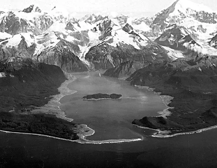
The scablands are a textbook of features that, taken individually, might be explained away, but taken together demand something extraordinary. There are coulees, a regional word for steep-walled dry canyons, abandoned channels with no river remotely large enough to have cut them. Grand Coulee, the largest, runs about 50 miles long and is one to five miles across. There are dry cataracts, the fossilized skeletons of waterfalls left high and dry when the water that made them disappeared.
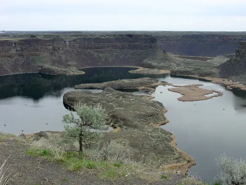
Dry Falls is the most staggering. Today it is a silent, scalloped precipice with four major alcoves, 3.5 miles wide and roughly 400 feet high, with groundwater-fed lakes resting in the plunge pools at its foot. Niagara Falls, by comparison, is about a mile wide with a 165-foot drop. When water poured over Dry Falls, it was several times the scale of the largest waterfall on the planet today, running through open desert.
Farther south, on the Palouse River, the water is still flowing, barely. Palouse Falls drops 198 feet over a near-vertical basalt face into a canyon that exposes a thick cross-section of the lava flows. The Palouse River reaches the falls by an improbable route: the Ice Age floods overtopped its old valley divide and forced the river into a new channel toward the Snake, a hijacking written permanently into the map.
Then there are the potholes and rock basins, circular, steep-sided pits punched into the bedrock, and this is where the physics gets strange. Many were carved by kolks, underwater vortices, essentially submerged tornadoes, that form in very deep, very fast water. A kolk spins a high-shear column of water against the rock and can pluck multi-ton blocks of basalt out of the ground and carry them away in suspension, something ordinary rivers cannot do. The phenomenon was first recognized by Dutch engineers watching floodwaters hoist riprap blocks off breached dikes. In the scablands, kolks scoured the rock basins below Dry Falls and across the channel floors.
And scattered across the region are erratics, boulders of granite and other rock types that do not belong, carried in and dropped far from any source, many of them rafted inside icebergs that floated on the floodwaters and grounded as the water fell.
The Doctrine Bretz Was Fighting
To understand why Bretz’s idea was treated as something close to heresy, you have to understand the ground rules of geology in the 1920s. Since the late eighteenth century, the science had been built on uniformitarianism, the principle most associated with Charles Lyell that the same slow, steady processes we see operating today, rivers cutting valleys grain by grain, coastlines retreating over eons, are sufficient to explain everything in the rock record, given enough time. The motto was that the present is the key to the past.
Its rejected rival was catastrophism, the older view that Earth had been shaped by sudden, violent events. By Bretz’s day, catastrophism carried a serious stigma. It was associated with pre-scientific thinking and, worse for a professional geologist, with biblical flood geology and Noah’s deluge. To invoke a continent-scale flood was, in the eyes of many of Bretz’s peers, to take a step backward toward superstition. Whether they consciously feared the religious reading or simply found gradualism more rigorous, the establishment had a powerful prior commitment against exactly the kind of explanation the scablands seemed to require.
Bretz, for his part, had no theological agenda. He had a landscape that refused to be explained any other way, and a stubborn willingness to follow the evidence past the edge of respectable opinion. As he put it in 1928, “Ideas without precedent are generally looked upon with disfavor and men are shocked if their conceptions of an orderly world are challenged.”
Two Papers, and a Word He Coined
Bretz did not begin as a credentialed insider. Born in Saranac, Michigan, in 1882, he took a biology degree and taught high school science in Seattle, where, around 1910, a newly published topographic map of the Potholes Cataract caught his attention. He could not see how such a feature had formed without a river leading to it, and the geology faculty at the University of Washington could not tell him. He went to the University of Chicago for a PhD, returned as a faculty member there, and in the summer of 1922 began leading field parties of advanced students into eastern Washington.
He published two papers in 1923. The first, in the Bulletin of the Geological Society of America, was cautious; he described the physiography in detail and deliberately avoided invoking catastrophe, though he noted that the channels demanded “prodigious quantities of water.” The second, in the Journal of Geology, a journal to whose editorial board he had recently been appointed, was the bomb. In it he coined the term Channeled Scabland and laid out the full hypothesis: a single immense flood, which he named the Spokane Flood, had swept the Columbia Plateau. He produced the first geomorphic map of the whole anastomosing channel network, and he interpreted the great mounded gravel deposits as bars laid down by a river flowing deep and fast over the entire surface.
“All other hypotheses meet fatal objections… It was a debacle which swept the Columbia Plateau.”, J Harlen Bretz, The Channeled Scablands of the Columbia Plateau, Journal of Geology, 1923
His map, drawn by boot and eye in the 1920s, is so accurate that it reads as a near-tracing of modern satellite imagery. That accuracy is what makes the rest of the story land. Bretz’s critics had theory on their side. Bretz had the ground.
The Great Scablands Debate of 1927
By the time of the famous Cosmos Club meeting on January 12, 1927, the 423rd meeting of the Geological Society of Washington, Bretz had published a string of papers tracing the flood downstream to the Snake and Columbia rivers, estimating water depths over 200 meters at the Wallula Gap where all the channels reconverged. The society devoted an entire evening to his talk, “Channeled Scabland and the Spokane Flood,” and then to demolishing it.
The lineup of critics came largely from the U.S. Geological Survey. W.C. Alden objected that no known mechanism could melt enough ice fast enough, and that he could not accept all the channels forming at once in a single brief event. James Gilluly pressed the same points with quantitative arguments, insisting the discharges Bretz needed were impossible. E.T. McKnight, G.R. Mansfield, and others added specific objections. Oscar Meinzer argued that an ordinary Columbia River, merely swollen by glacial meltwater over a long time, could have done the work. Crucially, as the historical record makes plain, none of these men had visited the scablands. They were defending a principle against a description.
Bretz called them the “challenging elders,” and he did not back down. But he had a gaping hole in his case, and his opponents knew it. If a flood this size had really happened, where had all that water come from? Bretz had floated the idea that volcanic heat under the Cordilleran Ice Sheet might have melted it suddenly. It was unconvincing, and he knew it. The man who had the answer was sitting in the audience, and he said nothing.
The Silent Man and the Missing Lake
His name was Joseph Thomas Pardee, a geologist with the USGS. As far back as 1910, Pardee had published a paper describing an enormous ice-age lake in western Montana, Glacial Lake Missoula, impounded when a lobe of the Cordilleran Ice Sheet, the Purcell Trench lobe, pushed south down the Idaho panhandle and dammed the Clark Fork River near present-day Sandpoint. The lake’s old shorelines are still etched as horizontal “strandlines” on the hills above the city of Missoula.
Pardee had the source. There is good reason to think that by 1927 he privately suspected the connection between his lake and Bretz’s flood. But Pardee worked for the Survey, the very institution lined up against Bretz, and he stayed quiet at the debate. Whether out of institutional caution or scientific reticence, his silence helped leave Bretz’s hypothesis stranded without its water for years.
Pardee returned to the problem late. In 1940 he gave a talk, modestly titled “Ripple Marks (?) in Glacial Lake Missoula,” and in 1942 he published the landmark paper “Unusual currents in Glacial Lake Missoula, Montana” in the GSA Bulletin. There he described the decisive evidence: across the floor of the Camas Prairie basin in northwestern Montana run parallel ridges of gravel up to about 15 meters high and spaced as much as 150 meters apart. They are giant current ripples, the same ripple forms you see in sand on a streambed or a beach, but gigantic, and built of cobbles and boulders rather than sand. Ripples that big can only be made by water of staggering depth and speed. Pardee had found the fingerprint of the lake draining catastrophically through its narrows, and he calculated the currents needed to roll the boulders.
Pardee’s lake closed Bretz’s case, and the two halves clicked together: the ice dam held back a continental volume of water, the dam failed, and the lake emptied across Washington in days. The combined picture is sometimes called the Bretz–Pardee theory. Ironically, when Pardee first suggested Lake Missoula to Bretz back in the 1920s, Bretz hesitated, worried the lake might not hold enough water to do the job. He was, on that single point, wrong in the right direction, the lake held more than enough.
The Physics and the Scale
Glacial Lake Missoula was not a pond. At its maximum it was roughly 600 meters deep at the ice dam and covered about 3,000 square miles, with its surface near 1,300 meters elevation. Estimates of its maximum volume cluster around 2,000 to 2,600 cubic kilometers; the most commonly cited figure is roughly 2,500 km³, and the lake is routinely compared to Lake Erie and Lake Ontario combined. That is the reservoir. Now picture the dam holding it back being made of ice.
The failure mechanism is itself elegant and terrifying. The lake had no outlet over land. As it deepened against the ice dam, the water eventually rose high enough to begin floating the ice, or to force its way underneath through pressurized tunnels. Once water started flowing beneath the dam, friction melted and enlarged the conduits, the process ran away with itself, and the dam disintegrated. The lake then drained in a day or two. This kind of glacial outburst flood has a name borrowed from Iceland, where they happen on a smaller scale: a jökulhlaup (roughly “glacier burst”). Bretz, fumbling toward the idea, had reached for the same Icelandic concept of a glacier-burst flood years before the mechanism was understood.
The numbers attached to the resulting flood are the reason this story matters beyond regional curiosity. The canonical estimate comes from the U.S. Geological Survey’s Jim O’Connor and the University of Arizona’s Victor R. Baker, in their 1992 GSA Bulletin paper “Magnitudes and implications of peak discharges from glacial Lake Missoula.” Their conclusion is worth quoting directly:
“Within the Spokane Valley, near the point of release, the peak discharge probably exceeded 17 ± 3 million m³·sec⁻¹. Downstream at Wallula Gap, a major point of flow convergence, peak discharge was about 10 ± 2.5 million m³·sec⁻¹… These are the largest known terrestrial fresh-water flows.”, O’Connor & Baker, GSA Bulletin, 1992
To put 17 million cubic meters per second in human terms: it is on the order of ten times the combined flow of every river on Earth, and the peak discharge at Wallula Gap, about 10 million m³/s, is roughly thirteen times the flow of the Amazon. The maximum flow velocity is commonly given as around 36 meters per second, about 80 miles per hour. Water that deep and that fast does not so much erode the rock as demolish it. It strips loess, plucks basalt with kolks, and rafts boulders for hundreds of kilometers, then races on through the Columbia Gorge and out into the Pacific, more than 700 kilometers from the dam, within a few weeks.
Here honesty requires a caveat, because a single exact number is not settled science. The O’Connor–Baker figures are field-based reconstructions from high-water marks, and later hydraulic modeling has refined the picture. Roger Denlinger and Daniel O’Connell, in a 2010 GSA Bulletin study, ran a two-dimensional shallow-water model over the real terrain and found, for a large but not maximal flood, peak discharges in eastern Washington ranging from 10 to 20 million m³/s, broadly consistent with the classic estimate rather than overturning it, while constrictions in the Columbia Gorge held the discharge there below about 6 million m³/s and stretched out the flood’s duration. Other summaries put discharge at the breached ice dam in the Idaho panhandle at two or three times the eastern-Washington value, as high as 25 million m³/s. The bottom line: these are unambiguously the largest known freshwater floods in Earth’s history, but the precise peak depends on which flood, which reach, and which method, and reasonable estimates span a wide band.
The Long Road to Vindication
Pardee’s 1942 paper did not flip the field overnight, but the ground began to shift. Through the 1950s and into the 1960s, more geologists actually visited the scablands, and the accumulating field evidence became impossible to wave away. By the time advances in the understanding of high-energy flood processes caught up in the 1960s and 1970s, the physical mechanisms turned out to be entirely consistent with the evidence Bretz had described forty years earlier.
The symbolic moment of surrender came in 1965. The International Association for Quaternary Research (INQUA) held its congress in the United States, and one of the field excursions visited the Columbia Basin scablands. Bretz, by then 82 and in poor health, did not attend. According to Stephen Jay Gould, who recounted the episode in “The Great Scablands Debate” in his collection The Panda’s Thumb, the touring geologists sent Bretz a telegram that ended: “We are now all catastrophists.” It is one of the most quoted lines in the history of geology. It deserves a note of caution: it is very widely reported, including by Gould, but it is known through that retelling rather than from a verified scan of the original telegram. Bretz himself reportedly said the recognition, after roughly thirty years and thirty papers in self-defense against more than thirty opponents, “did my heart good like medicine.”
Then the satellites arrived. When the first Landsat (ERTS) imagery of the region became available in the early 1970s, the anastomosing channel network Bretz had mapped on foot snapped into view from orbit exactly as he had drawn it. The pattern that had been too big to see from the ground was unmistakable from space.
In 1979, the Geological Society of America awarded Bretz its highest honor, the Penrose Medal. He was 96 years old. As National Geographic recounts, by the time the field’s highest honor reached him, “it was 1979 and Bretz was 96 years old. He joked to his son, ‘All my enemies are dead, so I have no one to gloat over.'” He died on February 3, 1981. The Missoula floods are now sometimes called the Bretz floods in his honor, a scientist who lived long enough to watch his heresy turn into the textbook account.
“Understanding the Scablands involves imagination and courageous departure from accepted views.”, J Harlen Bretz, 1959
How Many Floods? The Debate That Replaced the First One
Once the scientific community accepted that the floods were real, a new argument took its place: how many were there? Bretz had originally imagined one great debacle, later allowing for perhaps up to seven. The question turned out to hinge on thin, beautiful layers of sediment.
In quiet backwater basins where floodwater ponded behind constrictions, the Walla Walla and Yakima valleys, each flood dropped a graded layer of silt and sand called a rhythmite (a rhythmically repeated bed). Stack enough floods and you get a striped cliff. In 1980, the USGS geologist Richard B. Waitt published “About forty last-glacial Lake Missoula jökulhlaups through southern Washington” in the Journal of Geology, arguing that the roughly forty superposed rhythmites in places like Burlingame Canyon each recorded a separate filling and emptying of Glacial Lake Missoula. His single most persuasive piece of evidence was a Mount St. Helens ash layer capped by windblown dust, sitting within the sequence: proof that real time, with quiet intervals, had elapsed between floods rather than the whole stack being laid down in surges during one event. He developed the case further in his 1985 GSA Bulletin paper, “Case for periodic, colossal jökulhlaups from Pleistocene glacial Lake Missoula.”
The count kept climbing as new sections were studied. Brian Atwater’s composite Manila Creek section in the Sanpoil valley records about 89 flood beds interbedded with annual lake layers, the most complete stratigraphic record of the flooding yet found, though whether every one of those beds records a Missoula flood specifically is debated, since some may instead record discharges from the Cordilleran ice to the north. More recent work by Michelle Hanson and John Clague, in a 2016 Quaternary Science Reviews paper on the record in Glacial Lake Columbia, anchored part of the chronology with a radiocarbon age of 13,400 years on plant material found below 37 flood beds at one section, constraining the timing of the younger floods.
The honest synthesis, and the one most current specialists hold, is that there were many tens of late-Pleistocene megafloods, commonly summarized as “40 or more”, spread over roughly two thousand years near the end of the last Ice Age, with the early floods larger and decades apart and later ones generally smaller and more frequent as the climate warmed and the ice dam weakened. Not all of them necessarily came from Lake Missoula; some water may have come from glacial reservoirs in British Columbia. The exact tally and the exact source of every flood remain open. Attributing a single number to the whole episode would misrepresent the evidence; the count belongs to the layers, and the layers are still being read.
The Legacy: From Eastern Washington to Mars
Bretz’s vindication did more than settle a local argument. It rehabilitated catastrophism as a legitimate scientific idea, not the biblical kind, but the recognition that rare, high-energy events genuinely shape planetary surfaces. That shift in thinking helped clear the intellectual path for ideas like the asteroid impact that ended the age of dinosaurs, a controversy Bretz lived just long enough to see erupt. The scablands also founded the modern science of paleoflood hydrology, the discipline of reconstructing ancient flood magnitudes from the marks they leave, which now informs flood-risk assessment worldwide. Glacial outburst floods, once an exotic Icelandic curiosity, are recognized today as a major geomorphic force from the Himalaya to Patagonia.
The strangest legacy is off-world. When Mariner 9 and the Viking orbiters returned images of Mars in the 1970s, planetary scientists saw enormous channels with streamlined islands, longitudinal grooves, and scoured floors, features that looked uncannily like the Channeled Scabland. Victor Baker, who had spent his career on Bretz’s floods, drew the comparison explicitly in a 1978 paper in Science on the Spokane Flood controversy and the Martian outflow channels. The resemblance reframed the scablands as the essential terrestrial analog for reading megaflood landscapes on another planet.
The case continues to this day. Channels emanating from Cerberus Fossae, a system of tectonic fissures in the Elysium Planitia region of Mars about 270 kilometers long, feed into Athabasca Valles, thought to be the youngest outflow-channel system on Mars. Devon Burr, Alfred McEwen, and colleagues at the University of Arizona and NASA argued in a 2002 study in Icarus that the streamlined forms and grooves there record repeated catastrophic releases of pressurized groundwater, with peak discharges on the order of a million cubic meters per second, recognizable as kin to what Bretz described in eastern Washington half a century earlier.
What the Bretz Episode Teaches
The easy version of this story is a feel-good one: a maverick beats the establishment. The real lesson is more uncomfortable, and more useful. Bretz’s critics were not fools or villains. They were rigorous scientists defending a principle, uniformitarianism, that had served geology brilliantly and had been hard-won against genuine pseudoscience. Their failure was narrower and more human: they argued from theory against a man who had argued from the ground, and most of them never bothered to go look. The decisive evidence, Pardee’s giant ripples and the rhythmite layers, was always out there waiting to be walked over and counted.
Science did eventually self-correct, but it took a generation, a dead lake’s fingerprints, a telegram, and finally a view from orbit. The philosopher Thomas Kuhn’s grim observation hangs over the whole affair: paradigms often change not because opponents are persuaded but because they die and a new generation grows up with the new idea as ordinary. Bretz’s own joke about his dead enemies is the same point told as a punchline. The scablands are a monument to a flood. They are also a monument to how slowly, and how grudgingly, even a healthy science changes its mind, and to why fieldwork, the stubborn habit of going to look, remains the thing that finally forces the change.
Frequently Asked Questions
What are the Channeled Scablands?
The Channeled Scablands are a roughly 12,000-square-mile region of eastern Washington where Ice Age megafloods stripped away the soil and carved a maze of channels, dry canyons (coulees), dry waterfalls, and rock basins into the underlying Columbia River Basalt. The name comes from the bare, “scabbed” rock left exposed after the floods. Geologist J Harlen Bretz coined the term in 1923.
How big were the Missoula floods?
They were the largest known freshwater floods in Earth’s history. O’Connor and Baker (1992) estimated peak discharge near the release point in the Spokane Valley at about 17 ± 3 million cubic meters per second, roughly ten times the combined flow of all the world’s rivers, with flow velocities near 36 meters per second (about 80 mph). Exact figures are debated and depend on which flood and which location, but the floods were unambiguously cataclysmic.
Who was J Harlen Bretz?
J Harlen Bretz (1882–1981) was an American geologist at the University of Chicago who, in the 1920s, proposed that the Channeled Scablands were carved by a sudden catastrophic flood. His “outrageous hypothesis” was ridiculed for decades because it conflicted with the doctrine of uniformitarianism. He was eventually proven right and received the Geological Society of America’s Penrose Medal in 1979 at age 96.
How many Missoula floods were there?
The number is debated. Bretz first imagined one flood; Richard Waitt argued in 1980 for “about forty” based on rhythmite layers and a Mount St. Helens ash bed; later sediment records, such as Brian Atwater’s Sanpoil valley sections, suggest around 89 flood beds. The current consensus is that there were many tens of floods, commonly summarized as “40 or more”, over roughly 2,000 years, though not all necessarily came from Glacial Lake Missoula.
What was Glacial Lake Missoula?
Glacial Lake Missoula was an enormous Ice Age lake in western Montana, formed when a lobe of the Cordilleran Ice Sheet dammed the Clark Fork River. At its maximum it was about 600 meters deep and held on the order of 2,000–2,600 cubic kilometers of water, comparable to Lake Erie and Lake Ontario combined. When its ice dam repeatedly failed, the lake drained catastrophically, producing the Missoula floods.
Can you visit the Channeled Scablands?
Yes. Key sites are open to the public, including Sun Lakes–Dry Falls State Park (with an interpretive center at the dry cataract), Palouse Falls State Park, and Grand Coulee. The giant current ripples at Camas Prairie, Montana, and the strandlines above the city of Missoula are also accessible. Many sites are linked by the Ice Age Floods National Geologic Trail.
Why was Bretz ridiculed for so long?
Bretz was ridiculed because his flood hypothesis violated uniformitarianism, the reigning principle that geological change happens slowly and steadily, and because most of his critics never visited the scablands to see his evidence firsthand. Catastrophic flooding also carried an association with biblical flood geology, which professional geologists were eager to avoid. Compounding the problem, Bretz initially could not identify a water source. Most of his critics never visited the scablands, and the field evidence that vindicated him, Pardee’s giant current ripples and the rhythmite layers, took decades to be fully recognized.