Introduction
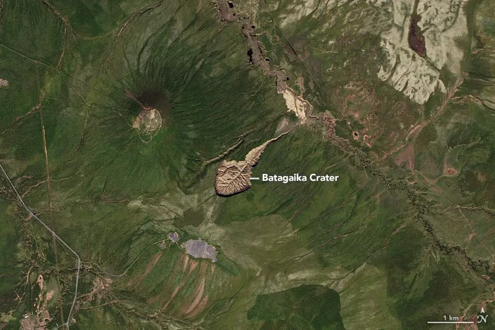
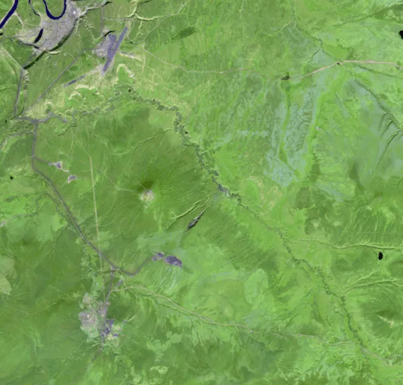
The Batagay megaslump, often called the Batagaika crater, is the largest retrogressive thaw slump on Earth, a kilometre-wide chasm in the permafrost of northern Yakutia. Walk through the larch forest southeast of the town of Batagay and you will hear the place before you see it. The Even and Sakha people who live here describe a cracking, sighing sound carried on the wind. Then the trees stop. The ground falls away. You are standing on the rim of a kilometre-long amphitheatre of mud and ice, its walls striped like the layers of a cut cake, meltwater threading down to a churned floor far below. Locals call it the “gateway to the underworld”, headlines prefer “gateway to hell.” Geologists call it the Batagay megaslump, and it is the largest feature of its kind on the planet.
This is not a meteorite crater, nor a volcanic vent or explosion pit. It is a wound in frozen ground that has been opening, year after year, for more than half a century, and the speed at which it grows has made it one of the clearest windows we have into what happens when ancient permafrost thaws.
What the Batagay crater actually is
The proper name for the Batagay crater is a retrogressive thaw slump, and the word “crater” is misleading enough that the scientists who study it keep correcting the record. Roger Michaelides, an Earth and planetary sciences researcher who works on permafrost, has put it bluntly: a crater is a bowl-shaped hole made by a meteorite, a volcano, or an explosion. Batagay is none of those. It is a landslide in slow motion, driven by the thaw of frozen ground.
A retrogressive thaw slump, or RTS, belongs to a family of landforms called thermokarst. Thermokarst is the uneven, collapsing terrain that forms when ice-rich permafrost thaws and the ground loses the frozen scaffolding that held it up. “Retrogressive” describes the direction of growth. The slump does not spread outward from a centre; it eats backward into a slope as a steep cliff, the headwall, retreats uphill.
Permafrost is the foundation of the whole story, so it is worth defining precisely. Permafrost is ground, soil or rock, that stays at or below 0°C for at least two consecutive years. Around Batagay the permafrost is continuous and cold, with mean annual ground temperatures between −8.0°C and −5.5°C, and in the wider Yakutia region it reaches roughly 1.6 kilometres deep. Only a thin surface layer, the active layer, thaws each summer here, between 0.2 and 1.2 metres depending on the soil and vegetation.
The ground at Batagay is not merely frozen. It is extraordinarily rich in ice. Thomas Opel, a paleoclimatologist at Germany’s Alfred Wegener Institute who has studied the site for years, has said the permafrost in the slump is about 80% ice. That detail matters more than almost any other, because it explains why the hillside, once disturbed, could not stop collapsing.
The geographic setting is the Yana Highlands of northern Yakutia, part of Russia’s Sakha Republic, at roughly 67.58°N and 134.77°E. The slump sits on a hillslope about 10 kilometres southeast of the town of Batagay and a few kilometres from the settlement of Ese-Khayya, around 660 kilometres north-northeast of the regional capital, Yakutsk. It takes its name from the nearby Batagayka River, a tributary of the Yana. From the air the slump looks like a tadpole or a stingray, a rounded head pointing into the hillside and a long tail draining toward the Batagay River floodplain.
A megaslump is simply a retrogressive thaw slump that has grown past 20 hectares. Batagay is far past that threshold, which brings us to its size.
How big is the Batagay megaslump?
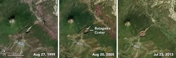
The most recent peer-reviewed measurement comes from a 2024 study in the journal Geomorphology, led by Alexander Kizyakov of Lomonosov Moscow State University with a team of a dozen co-authors from Russia and Germany. They put the slump’s area at 87.6 hectares in 2023, counting both the main bowl and the erosional outlet that drains it, which confirms Batagay as the largest known retrogressive thaw slump on Earth.
The numbers on width come with a wrinkle worth being honest about. An earlier dimensional study reported the maximum width as 890 metres, with the headwall standing about 55 metres from the upper edge down to the slump floor. The 2024 Geomorphology paper traces the widening directly: the slump measured 790 metres across in 2014, reached 890 metres in 2019, and was about 990 metres wide by the summer of 2023. So the widely repeated “990 metres” figure is not media exaggeration; it is the 2024 measurement from the same research group, while 890 metres is the slightly older 2019 value. Either way, the slump grew on the order of 200 metres wider in under a decade. In length, it stretched roughly 1.8 kilometres in 2019.
Depth is where popular accounts drift apart, and the distinction is technical. The headwall, the active cliff face, is about 55 metres high from rim to floor in the peer-reviewed measurements. NASA’s Earth Observatory described the cliff faces as more than 85 metres tall in places in 2016, and other summaries cite depths approaching 100 metres for the deepest incision. The difference likely comes down to what is being measured: the height of the actively retreating headwall versus the total relief from the highest part of the rim to the lowest point of the floor. The most defensible reading is that the headwall is around 55 metres in the peer-reviewed work, while popular accounts citing 85 to 100 metres are describing the deeper total relief of the most incised sections.
One comparison from the 2024 work has stuck in headlines for good reason. The volume of ice and sediment lost from Batagay since it formed is equivalent to more than 14 Great Pyramids of Giza. That is not a forecast. It has already happened.
How the gateway to the underworld formed
Batagay is a paradox. The ground it exposes is some of the oldest frozen ground on Earth, yet the slump itself is young, and it was triggered by people.
The trouble began with the removal of the forest. Through the 1940s, 1950s, and 1960s, tree clearance and off-road vehicle traffic stripped away the taiga vegetation and the insulating organic mat on this particular hillslope. That mat is the permafrost’s sunscreen. Larch and birch shade the ground, mosses and lichens hold moisture, and together they keep summer heat from reaching the ice below. Strip the cover, and sunlight starts cooking the frozen soil.
The Murton-led review of the site describes a clear sequence. After the vegetation was disturbed, a hillslope gully formed by the early 1960s. That gully cut down into the permafrost, exposing ever more ice to the air, and during the 1980s it began to slump along its central part. By the 1990s the feature had enlarged past 20 hectares and become a true megaslump. Once the ice-rich ground was opened, the process fed itself: thaw exposed more ice, the exposed ice thawed and the ground collapsed, the collapse exposed still more ice. Mary Edwards of the University of Southampton summed up the trap precisely. “Once you’ve exposed something like this, it’s very hard to stop it,” she said. “Every year as soon as temperatures go above freezing, it’s going to start happening again.”
Here is the first real uncertainty, and it is worth flagging rather than papering over. Sources disagree on exactly when the slump “began.” The 2024 Geomorphology paper is itself internally split: its highlights date initiation to the 1990s, while its abstract and conclusion refer to formation in the 1970s. NASA’s Earth Observatory says the crater likely began growing in the early 1980s and tracks the feature on satellite imagery from 1999, while the gully behind it is visible in declassified imagery going back to the 1960s. The slump was first widely recognised on satellite images in 1991. These dates are not really contradictory once you separate the stages, gully, then slump, then megaslump, but anyone who tells you Batagay “started” in a single tidy year is smoothing over a process that unfolded across decades.
What makes Batagay so instructive is that it separates the trigger from the fuel. Human disturbance lit the match. But the slump could only grow into a monster because the permafrost beneath was so cold, so thick, and so loaded with ice, and because the regional climate has been warming fast. The Arctic is heating extraordinarily quickly: a 2022 analysis by Rantanen and colleagues in Communications Earth & Environment found that over the previous 43 years the Arctic warmed nearly four times faster than the globe as a whole, about 3.8 times the global rate since 1979, a sharper figure than the “twice as fast” rule of thumb long repeated in earlier reports. In June 2020 the town of Verkhoyansk, in the same Yakutia region, hit 38°C, a reading the World Meteorological Organization later confirmed as the highest ever recorded north of the Arctic Circle. Summers like that are what keep the headwall retreating.
How fast is the Batagaika crater growing?
This is the question the 2024 Geomorphology study was built to answer, and the team answered it with a level of precision the site had never had before. They combined high-resolution satellite imagery, drone surveys, field measurements, and laboratory analysis of frozen samples to build a three-dimensional model of how much material is leaving the slump and what that material is made of.
The headline figure: Batagay loses about 1 million cubic metres of material every year. The 2024 paper states that since 2014, the annual mobilised volume amounts to roughly 1 million cubic metres per year. Of that yearly loss, about two-thirds is ground ice and about one-third is thawed permafrost sediment.
Stack up the decades and the totals are large. From its formation until 2023, the paper reports, the slump mobilised about 34.7 million cubic metres of material, of which roughly 23.4 million cubic metres were melted ground ice and 11.3 million cubic metres were thawed deposits. The study’s own highlights round this to “ca. 35 million m³,” and some news coverage cited 34.6 million; the precise figure in the body of the paper is 34.7 million cubic metres. That is the volume behind the “14 Great Pyramids” comparison.
The headwall, the cliff at the back of the slump, is the engine of this growth, and its retreat rate is the second open question in the Batagay story. Different studies over different periods report different speeds, and the range is real rather than a sign that someone is wrong. The 2024 paper compiles them: average headwall retreat of 7 to 15 metres per year for 2004 to 2010, 11.3 to 14.9 metres per year recalculated for 1991 to 2018, and earlier estimates of up to 30 metres per year. Kizyakov himself described recent retreat as varying from 5 to 15 metres per year. Several reports settle on about 12 metres per year as a representative recent figure. Frank Günther of the University of Potsdam noted that the headwall advanced roughly 10 metres a year for decades, then sped up to 12 to 14 metres a year after 2016. The takeaway is not a single number but a pattern: the cliff has been retreating on the order of 10 to 15 metres most years, with occasional bursts higher, and it shows no sign of stabilising.
There is a ceiling on the growth, though, and the 2024 team was careful to describe it. The floor of the slump has nearly reached bedrock in many places, so Batagay cannot get much deeper. What it can do is keep widening and pushing upslope along its margins. Kizyakov expects “only expansion along the margins and upslope.” Nikita Tananaev, lead researcher at the Melnikov Permafrost Institute in Yakutsk, has warned that with continued heat the slump has enough room to spread over the adjacent valley, and that the valley could be “absorbed in the next decade or two.” A thaw slump stops only when it runs out of ice or runs into a geologic limit such as the top of the slope or a body of water.
The 650,000-year ice archive
Set the alarm aside and Batagay reads as something else entirely: one of the best-preserved long records of past climate anywhere in the Northern Hemisphere. The same headwall that is collapsing is also a cliff-face cross-section through more than half a million years of frozen history, exposed and readable.
In 2022, a team led by Julian Murton of the University of Sussex published a multimethod dating study in the journal Quaternary Research that pinned down the age of the oldest ice. They attacked the problem with four independent techniques: optically stimulated luminescence dating of quartz grains, post-infrared infrared-stimulated luminescence dating of potassium feldspar, radiocarbon dating of organic material, and a chlorine-36 method applied directly to the ice wedges. Luminescence dating works by measuring how long mineral grains have been buried in the dark since they last saw sunlight; the chlorine method dates the ice itself.
Their conclusion: the lowest ice unit at Batagay developed at least 650,000 years ago, potentially during a glacial period known as Marine Isotope Stage 16. That makes it the oldest directly dated permafrost in western Beringia, the oldest known anywhere in northern Eurasia, and the second-oldest known ground ice in the Northern Hemisphere. The only older ice on record is in Canada’s Yukon Territory, where syngenetic permafrost dated by Duane Froese and colleagues in 2008 came out at roughly 740,000 years.
The cliff reads as a stack of distinct layers, and geologists have mapped five main cryostratigraphic units. From the bottom up: the Lower Ice Complex, dated to MIS 16 or older, the 650,000-year ice itself; a Lower Sand unit, MIS 6 or older; a Woody Layer formed during the warm MIS 5 interglacial; the Upper Ice Complex, a body of classic Yedoma permafrost laced with huge ice wedges, formed from about 60,000 to 30,000 years ago during late MIS 4 to 3; an Upper Sand unit from MIS 3 to 2; and a thin Holocene cover at the top from the present interglacial, MIS 1. The two wood-rich forest beds are especially telling. They mark interglacial periods when the climate here was about as warm as today or warmer, and forests grew on a slope that is tundra and larch taiga now.
The Murton team’s deeper message is the one worth holding onto: this ancient permafrost survived multiple natural warm periods, some warmer than the present, across hundreds of thousands of years. It endured the climate. What it has not endured is people. “The ancient permafrost near the town of Batagay has been resilient to natural climate and environmental change over multiple glacial-interglacial cycles, but is vulnerable to human-induced disturbance,” Murton said. Cold, thick, ice-rich permafrost can outlast a warm interglacial. It cannot outlast having its protective forest peeled off.
Ice Age animals emerging from the headwall
Frozen ground is an exceptional preservative, and as Batagay’s headwall crumbles it keeps handing over the dead. Bones, teeth, tusks, and occasionally whole carcasses of Ice Age animals tumble out of the thawing cliff and collect on the slump floor, often beside the small meltwater streams.
The roll call is a textbook “mammoth steppe” fauna. Researchers have recovered the humerus of a cave lion, Panthera spelaea; the skull of a Pleistocene wolf, Canis lupus; and abundant bones, teeth, and tusks of woolly mammoth, Mammuthus primigenius, which is the dominant species at the site, along with steppe bison, Bison priscus, and the Lena horse, Equus lenensis. NASA’s Earth Observatory lists the horse, the bison, cave lions, and wolves among the animals that have emerged. Two younger carcasses, a Lena horse and a juvenile steppe bison from the Holocene, were found near the slump’s outlet, along with the remains of a musk ox and a roughly 4,400-year-old horse.
The most famous find came in August 2018. An expedition recovered the carcass of a foal of the extinct Lena horse from the Batagaika depression, dated to about 42,000 years old. The preservation was almost unreal. The animal still had its skin, hair, hooves, and tail intact, down to fine detail, and it was just one to two weeks old when it died, having most likely drowned in mud that then froze around it. Semyon Grigoriev, head of the Mammoth Museum at North-Eastern Federal University in Yakutsk, reported that the internal organs were well preserved and that even urine remained in the bladder. The team extracted liquid blood from the foal’s heart vessels, the oldest liquid blood ever recovered, beating the previous record by some 10,000 years. That preservation fed an ambition to find viable cells and attempt to clone the animal, an effort that, as of the reporting, had not succeeded after many attempts.
The slump preserves more than bones. A team led by Jérémy Courtin at the Alfred Wegener Institute used ancient DNA from the sediments, published in 2022 in the journal Environmental DNA, to reconstruct entire past ecosystems, from microbes to megaherbivores, across glacial and interglacial cycles. The picture that emerges, supported by the trapped plant remains, is of a surprisingly productive landscape. During the last ice age, even as winters plunged far colder than today, the vegetation was a lush meadow steppe that supported mammoths, woolly rhinos, horses, and bison. As the paleobotanist Kseniia Ashastina of the Max Planck Institute described it, “It was a paradise for the foraging animals.”
For the people who live here, the slump is not a wonder but a loss. Ashastina, who has stayed with Even and Sakha families during fieldwork, relayed their view of the megaslump plainly: “They say it’s eating their land, swallowing up the trees and their sacred places.”
What Batagay means for a warming Arctic
Batagay is spectacular, but its real significance is that it is a preview. It shows, at a scale you can see from orbit, what happens when ice-rich permafrost is pushed past a tipping point, and that has direct bearing on one of the larger uncertainties in climate science: the permafrost carbon feedback.
The logic of the feedback is straightforward. For tens of thousands of years, the frozen ground of the Arctic has been locking away the carbon in dead plants, animals, and microbes that never fully decomposed in the cold. The northern permafrost region holds an enormous amount of it. According to NOAA’s Arctic Report Card, northern permafrost soils contain 1,460 to 1,600 billion metric tons of organic carbon, about twice as much as is currently in the atmosphere. When permafrost thaws, microbes wake up and start consuming that ancient organic matter, releasing carbon dioxide and methane. Those gases warm the climate, which thaws more permafrost, which releases more carbon. NOAA’s measurements indicate the permafrost region is already releasing net carbon to the atmosphere, a sign the feedback may have begun.
Batagay puts hard numbers on the local version of this process. The 2024 Geomorphology study calculated that the slump releases 4,000 to 5,000 tonnes of previously frozen organic carbon every year, and that since it formed it has mobilised about 169,500 tonnes of organic carbon in total. Air sampled directly over the crater backs this up: a 2023 study by Beer and colleagues in Environmental Research Letters, summarised by the University of Texas Bureau of Economic Geology’s EarthDate program, found that carbon dioxide is being expelled from the slump at up to twice the normal rate for the surrounding region. A single slump is not going to swing the global carbon budget. But Batagay is a measurable, well-instrumented example of a process that is multiplying across the Arctic, and it lets scientists calibrate what abrupt thaw actually costs.
The wider worry is that there are many more Batagays waiting to happen, just smaller for now. A 2025 high-resolution inventory in Earth System Science Data manually mapped 6,168 active retrogressive thaw slumps on the Yamal and Gydan peninsulas of the West Siberian Arctic alone, a 23-fold increase in number since 1964. The pattern is not confined to Russia: on Banks Island in Arctic Canada, Lewkowicz and Way reported in Nature Communications in 2019 a 60-fold jump in thaw slumps between 1984 and 2015, with more than 4,000 new slumps initiated, most of them following four unusually warm summers. Tananaev’s warning is direct: “with increasing temperatures and anthropogenic pressure, we will see more and more of those mega-slumps forming, until all the permafrost is gone.” Abrupt thaw features like this one are not yet fully accounted for in the climate models that inform carbon budgets, which means the real-world feedback could run somewhat ahead of the standard projections.
There is also a local dimension that has nothing to do with global budgets. Thawing permafrost buckles roads, splits houses, and ruptures pipelines across northern Russia. The same physics that makes Batagay grow is undermining the infrastructure of the communities nearest to it.
Will the Batagay crater keep growing?
For the foreseeable future, yes. The slump is still active. Its floor has nearly hit bedrock, so it has little room to deepen, but its headwall continues to retreat into the hillslope, and the surrounding terrain still holds plenty of downslope ice for the slump to propagate into. As long as summers climb above freezing for long stretches, the exposed ice will keep thawing.
Batagay will not, despite the nickname, bore its way to the centre of the Earth. Thaw slumps end when they exhaust their ice or hit a topographic boundary. The 2024 team expects Batagay to keep expanding along its margins and upslope, and eventually to stabilise into an irregular landscape of sandy ridges and depressions once the ice runs out. But “eventually” may be decades away, and in the meantime the gateway will keep widening, keep shedding mammoth bones, and keep exhaling the carbon that ancient Siberia spent half a million years storing.
The gateway to the underworld is not a portal to anywhere. It is a hole in the ground, and what it exposes is the plain truth about ice, about time, and about what happens when the cold finally lets go.
Frequently asked questions
Is the Batagaika crater man-made?
Partly. The crater is a natural landform, a retrogressive thaw slump, but it was triggered by human activity. Clearing the forest and disturbing the ground in the mid-twentieth century stripped away the insulation that protected the permafrost, which allowed the ice-rich ground to thaw and collapse. The cold, ice-rich permafrost had survived natural warm periods for over 650,000 years; it was human disturbance, amplified by a warming climate, that set the slump in motion.
How deep is the Batagay crater?
The active cliff at the back of the slump, the headwall, is about 55 metres high from rim to floor in peer-reviewed measurements. NASA’s Earth Observatory described cliff faces exceeding 85 metres in places, and the deepest parts of the overall depression are sometimes cited as approaching 100 metres. The slump’s floor has nearly reached bedrock, so it cannot get much deeper; future growth will be mostly outward and upslope.
How fast is the Batagaika crater growing?
The slump loses about 1 million cubic metres of ice and sediment per year, according to the 2024 study in Geomorphology. Its headwall has been retreating on the order of 10 to 15 metres per year in recent decades, with some earlier estimates as high as 30 metres per year. It widened from 790 metres across in 2014 to about 990 metres in 2023.
What animals have been found in the Batagaika crater?
The thawing headwall has yielded woolly mammoth, steppe bison (Bison priscus), the extinct Lena horse (Equus lenensis), cave lions (Panthera spelaea), Pleistocene wolves, and musk ox, among others. The most celebrated find is a 42,000-year-old foal of the Lena horse recovered in 2018 with skin, hair, and even liquid blood preserved, the oldest liquid blood ever found.
How old is the permafrost at Batagay?
The oldest ice exposed in the slump is at least 650,000 years old, according to a 2022 multimethod dating study in Quaternary Research. That makes it the oldest directly dated permafrost in western Beringia, the oldest known in northern Eurasia, and the second-oldest known ground ice in the Northern Hemisphere, after roughly 740,000-year-old ice in Canada’s Yukon Territory.