Introduction
In the spring of 1930, a pilot flying for Fairchild Aerial Surveys banked over the flatwoods south of Myrtle Beach, South Carolina, with a heavy mapping camera bolted into the floor of the cabin. The Ocean Forest Company had hired the firm to photograph roughly five hundred square miles of coastal plain for a real-estate venture. The work was routine. The land below looked like most of the Carolinas lowcountry: pine, swamp, the occasional farm cut from the scrub. Then the prints came back from the darkroom, and the surveyors laid them out on a table.
Across the developed prints ran dozens of pale ovals, each one elongated, each one tilted the same way, like raindrops blown sideways across a windshield and frozen. Some were a few hundred meters long. A few stretched for kilometers. They overlapped without erasing one another. From the ground nobody had ever seen them whole, because at eye level a person standing in one would notice only a marshy rim and a stand of bay trees. The camera saw the pattern that the human eye on the ground could not. Within three years that pattern, the features we now call the Carolina Bays, would launch one of the longest-running arguments in American geology: whether the sky had once fallen on the Eastern Seaboard.
What the Carolina Bays Are, and Where They Hide
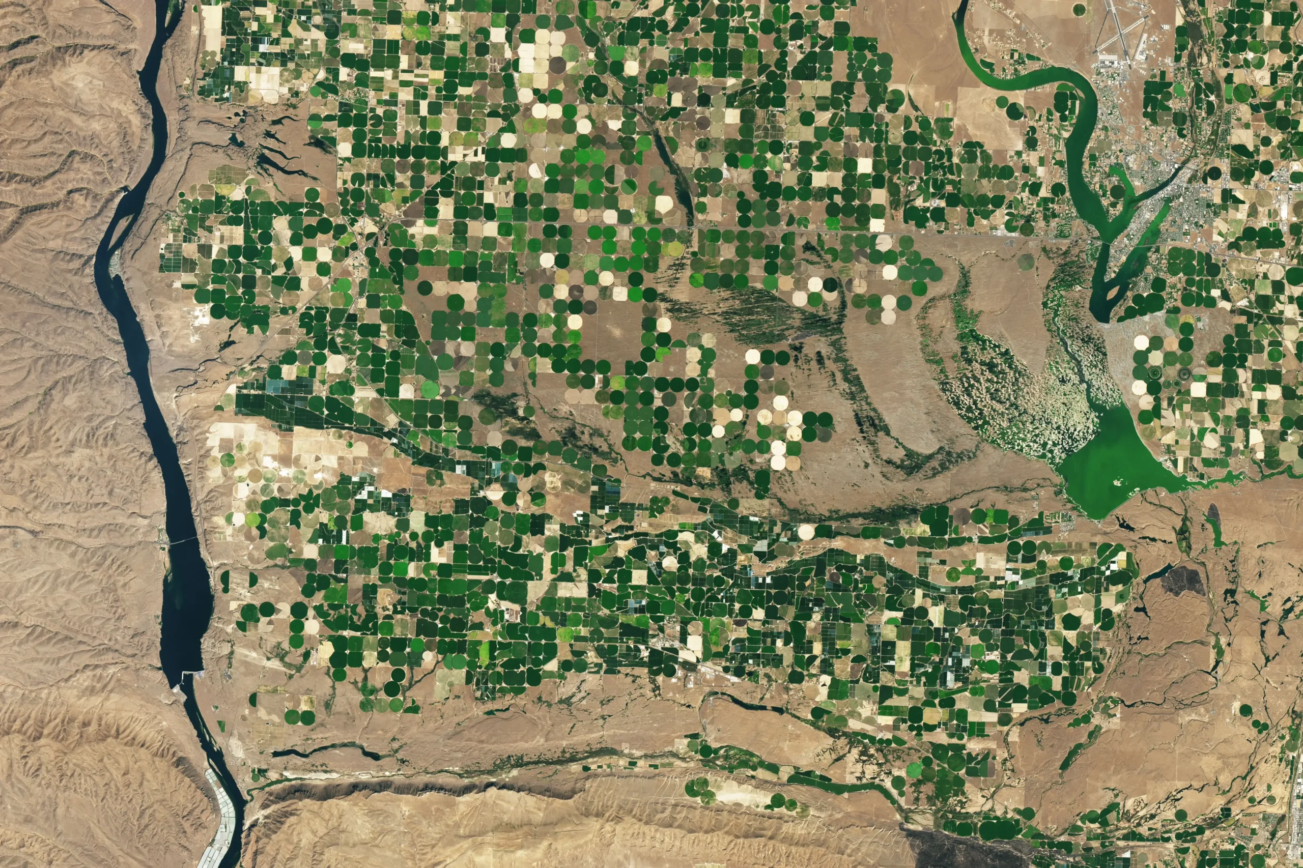
The Carolina Bays are shallow, elliptical depressions scattered across the Atlantic Coastal Plain of the eastern United States. They run from southern New Jersey down through Delaware, Maryland, Virginia, the Carolinas, and Georgia, fading out in northern Florida. The name is a regional accident. “Bay” here has nothing to do with the sea; it refers to the bay trees, sweet bay, loblolly bay, red bay, that crowd the wetter examples. In Maryland the same features are called Maryland basins; on the Delmarva Peninsula they go by Delmarva bays. They are the same kind of landform under different local names.
How many are there? That question has no clean answer, and the disagreement is worth understanding. William F. Prouty, working in 1952, estimated a conservative half a million across the classic region. Later workers counting at coarser resolution sometimes put the figure as low as ten thousand. The discrepancy comes down to what a person can see and how carefully they look. A faint, partly filled bay buried under farm fields and subdivisions is invisible on a 1950s topographic sheet and obvious on a modern laser-scanned elevation model. When Mark Lundine and Arthur Trembanis of the University of Delaware reviewed the literature in their 2021 Remote Sensing paper, they framed the range honestly: published population estimates have varied between roughly 10,000 and 500,000, a spread so wide that it became, in their words, a problem demanding automated detection rather than eyeballing.

The physical description has been stable for decades. A typical bay is an oval rimmed on its southeastern margin by a low ridge of white sand. The long axis points northwest to southeast. The deepest part of the basin sits offset toward the southeast, beneath that sandy rim. The bays are shallow relative to their width: a few meters deep against hundreds of meters across. They cluster densely on the broad, flat interfluves between rivers, and they have a habit of overlapping. A small bay can sit fully inside a larger one without either losing its shape. Their floors hold marsh, pond, peat bog, or open water depending on local hydrology, and a handful of the largest, such as Lake Waccamaw in North Carolina, are permanent lakes.
The numbers that anchor the modern picture
The most rigorous recent census comes from Lundine and Trembanis. Using a convolutional neural network trained on laser-altimetry data and turned loose on the whole coastal plain, their detector, in their words, “found over 23,000 Carolina Bays from southern New Jersey to northern Florida, with highest densities along interfluves.” Across that population, they report, the bays are “circular to ovate and shallow (median diameter of 222 m, median depth of 2.17 m, median area of 26,249 m2).” The “southern New Jersey to northern Florida” framing is the conventional one inherited from the older literature, even though the bays thin to near-absence at both ends; their true core runs from the Delmarva Peninsula to southern Georgia. These are modest landforms. The largest examples capture the imagination, but the central tendency of the population is a shallow oval about the size of a few city blocks, sunk only a couple of meters below the surrounding plain.
That shape matters for everything that follows. A depression two meters deep and two hundred meters wide has a depth-to-diameter ratio nothing like a hypervelocity impact crater, which excavates a deep bowl and throws out a ring of overturned, shocked debris. That mismatch in proportion is what the impact hypothesis would eventually founder on.
Discovery From the Air: A Pattern the Ground Concealed
People had noticed individual bays long before the airplane. The geologist L. C. Glenn published the earliest scientific notice in 1895, describing “lake-like expanses” near Darlington, South Carolina. But a single bay on foot is just a swamp with an odd sandy edge. Nobody could perceive the regularity of the field, the shared orientation, the sheer number, until the vantage point rose a few thousand feet.
Aerial photography changed the scale of the question in one stroke. When the 1930 Myrtle Beach prints reached the University of Oklahoma, two researchers there, the geologist Frank A. Melton and the physicist William Schriever, studied them with growing excitement. In 1933 they published a paper in the Journal of Geology with a title that reads like a dare: “The Carolina ‘Bays’—Are They Meteorite Scars?” Their abstract laid out four features that struck them as impossible to explain by ordinary erosion: the smoothly elliptical shape, the parallel alignment toward the southeast, the sandy rim that was consistently larger at the southeastern end, and the way overlapping bays interfered with one another’s outlines. Surface depressions, they argued, do not normally organize themselves this way. Something external had imposed the order.
Melton and Schriever proposed a meteorite shower, a swarm of bodies arriving on a common low-angle trajectory from the northwest. They estimated the swarm would have needed a cross-section of about 50,000 square miles to scar so much ground. It was a bold claim, and they knew it. They noted that the bays’ combination of traits was “not known to exist elsewhere on the Earth’s surface.” For a generation of readers, that single sentence framed the bays as a genuine anomaly, a riddle that demanded an extraordinary answer.
Why the impact idea felt obvious in 1933
Geologists in 1933 knew far less about impacts than we do now. The recognition of impact cratering as a major planetary process lay decades in the future. Eugene Shoemaker would not establish rigorous criteria for identifying terrestrial impact structures, using Meteor Crater in Arizona as his proving ground, until around 1960. In 1933 the very idea that the Earth’s surface recorded cosmic collisions was novel and thrilling. A field of aligned ovals that looked, from the air, like the splash pattern of a celestial buckshot blast fit the spirit of the moment. The hypothesis was not foolish. It was premature, built on a pattern seen from above before anyone had dug into the ground to test it.
A Graveyard of Hypotheses
For the next two decades the bays attracted explanations the way a vacuum attracts air. By the late 1940s a dozen or more competing origin stories had appeared in print, and most of them have since been discarded. The variety of those failed ideas is itself evidence of how hard the landform is to read from surface clues alone.
Some researchers invoked springs welling up from below and dissolving the surface. Others proposed solution basins formed where groundwater ate away buried limestone, a karst process. There were appeals to artesian springs, to fish nests scaled up to absurd dimensions, to segments of old beaches and lagoons stranded by retreating seas, to the scour of ocean currents over a submerged shelf, and even to the wallowing of giant Pleistocene animals. Each idea explained one or two features of the bays and stumbled on the rest. Spring basins do not align. Sinkholes do not share a single orientation across five states. None of the purely local mechanisms accounted for the disciplined northwest-southeast tilt that the aerial photographs had made undeniable.
Douglas Johnson and the groundwater school
The most substantial early terrestrial argument came from Douglas Johnson, a Columbia University geomorphologist, in his 1942 book The Origin of the Carolina Bays. Johnson rejected the meteorite idea and assembled a complex model driven by groundwater, artesian springs, and solution from below, modified by wind and wave action at the surface. His mechanism has not survived in its details. What survived was his insistence that the bays could be understood through known earthbound processes acting over long spans of time, and his careful measurement of bay orientations, which later workers would mine for decades. Johnson treated the alignment as something to measure, not a portent to marvel at.
Cooke’s tidal eddies and the USGS imprimatur
One terrestrial proposal carried the weight of the federal government. In 1954 the U.S. Geological Survey published Professional Paper 254-I, “Carolina Bays and the Shapes of Eddies,” by C. Wythe Cooke. Cooke argued that the bays had been shaped by rotating tidal eddies, vortices of water spinning over the coastal plain when it lay near sea level, and that the ideal shape carved by such an eddy is an ellipse. The paper’s subtitle promised “corroborative evidence that the elliptical Carolina bays were shaped by tidal eddies and that the shape of the ideal eddy is elliptical.” Cooke’s eddies did not hold up either; the bays sit too far inland and too high for the mechanism, and the hydrodynamics never convinced his peers. But the episode shows that serious institutions took the bays seriously, and that the leading terrestrial explanations all reached for moving water, moving air, or both.
By the early 1950s the field had sorted into two camps. One looked to the sky. The other looked to wind and water working on a sandy plain over tens of thousands of years. The terrestrial camp lacked a clean, single mechanism, and the impact camp had a vivid story. Stories travel faster than sediment cores.
Prouty, Meteor Showers, and the Romance of Catastrophe
The impact hypothesis found its most determined champion in William F. Prouty of the University of North Carolina. His 1952 paper in the Geological Society of America Bulletin, “Carolina Bays and Their Origin,” ran to fifty-seven pages and became the reference text for the cosmic interpretation. Prouty measured orientations across the region and reported something that looked like a smoking gun: the bays do not all point the same direction. Instead their long axes rotate systematically with latitude.
The figures, refined by Johnson in 1942 and later by Raymond Kaczorowski in 1977, trace a smooth arc. In east-central Georgia the average long axis runs about N16°W. It swings to roughly N22°W in southern South Carolina, N39°W in northern South Carolina, N49°W in North Carolina, and N64°W up in Virginia. To an impact theorist this fan of orientations looked like the divergent paths of projectiles spreading out from a common source somewhere to the northwest. Prouty and others speculated about a comet or meteor swarm coming in low from that direction.
The appeal is obvious. A single violent morning, a sky full of fire, half a million scars left across the coast as a permanent monument. It is a better campfire story than “the wind blew across shallow ponds for ninety thousand years.” The gap in storytelling appeal mattered later, when the idea resurfaced in the twenty-first century with the megafauna attached to it.
The orientation evidence cuts both ways
The orientation data contain a detail the catastrophists tended to underplay. If you project those rotating long axes northwestward, the lines do not converge on the Great Lakes or on Canada, where a large impactor would supposedly have struck. They converge, loosely, over southeastern Indiana and southwestern Ohio, and the convergence is far from tight. Worse for the projectile model, at the northern end of the distribution, on the Delmarva Peninsula and in New Jersey, the orientation does not continue the smooth rotation. It jumps abruptly by about 112 degrees to roughly N48°E, and farther north it becomes bimodal or simply random. No single trajectory from a single source can bend that way. A wind field that varies with latitude and local geography can. The orientation data, in other words, fit a climatic explanation at least as well as a ballistic one, and at the northern end, considerably better.
The Younger Dryas Comet: An Old Idea in New Clothes
The meteorite hypothesis might have remained a historical curiosity if not for a dramatic revival in 2007. That year a team led by Richard Firestone of Lawrence Berkeley National Laboratory published a paper in the Proceedings of the National Academy of Sciences with a sweeping title: “Evidence for an extraterrestrial impact 12,900 years ago that contributed to the megafaunal extinctions and the Younger Dryas cooling.” The Younger Dryas was a sharp return to near-glacial cold that began about 12,900 years ago and lasted over a thousand years. Its cause is genuinely debated. Firestone and colleagues proposed that a comet or its fragments struck or exploded over the Laurentide Ice Sheet near the Great Lakes, igniting continent-spanning fires, collapsing the Clovis culture, and helping wipe out mammoths, mastodons, and the rest of North America’s great Ice Age beasts.
The Carolina Bays were central to this story from the start. Firestone’s team sampled in and around fifteen Carolina Bays, describing them as part of “a group of ≈500,000 elliptical lakes, wetlands, and depressions that are up to ≈10 km long and located on the Atlantic Coastal Plain.” They reported elevated concentrations of supposed impact markers, magnetic microspherules, charcoal, glass-like carbon, nanodiamonds, in sediments they associated with the bays’ rims, and they leaned on the older work of Melton and Prouty to suggest the bays were impact-related. The hypothesis went public at a 2007 meeting of the American Geophysical Union and detonated across the popular press.
Why the public loved it
A killer comet that ended the age of mammoths and froze a continent is a story with obvious pull. It linked a familiar landscape feature to the most charismatic extinction in the hemisphere’s prehistory and to a real, puzzling climate event. Books and documentaries followed, along with a vigorous online following. The idea acquired a momentum largely independent of its evidentiary support. And it set up a clean test, because the hypothesis made a specific, checkable prediction: if a cosmic impact gouged the Carolina Bays at 12,900 years ago, then the bays should all date to that moment, and somewhere there should be a crater of the right age.
Both predictions turned out to be testable. Both turned out to be wrong. The instruments that delivered the verdict were a laser mounted in an airplane and a quartz grain that remembers when it last saw sunlight.
The LiDAR Revolution: Seeing the Bays Whole
For seventy years after the Myrtle Beach photographs, our view of the bays barely improved beyond what those first aerial cameras captured. Then came LiDAR, light detection and ranging, an airborne laser that pulses the ground millions of times and times the returns to build an elevation model accurate to a few tens of centimeters. Crucially, the technique can be filtered to strip away trees, buildings, and brush, leaving a “bare earth” model of the topography itself. A bay hidden for a century under a pine plantation or a housing tract reappears on the screen as a crisp oval.
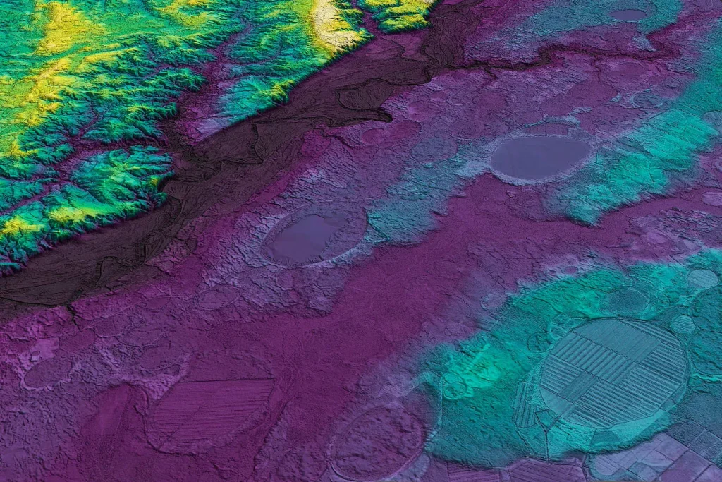
LiDAR did two things at once. It multiplied the count, confirming that the half-million estimate was conservative, and it exposed internal structure that the impact model had never predicted. The new elevation models showed many bays nested inside older bays, with multiple concentric sand rims marking former shorelines, and with whole basins that appeared to have crept across the landscape over time, leaving a trail of stranded rims behind them. A single instantaneous impact does not leave a basin that migrates across the landscape over thousands of years.
Teaching a machine to find half a million ovals
Counting bays by hand across nine states is impractical, so Lundine and Trembanis automated it. In their 2021 paper in Remote Sensing, they described training a convolutional neural network, the same class of algorithm that recognizes faces or cats in photographs, to recognize Carolina Bays in LiDAR-derived elevation images. They built the training set from one-meter-resolution elevation tiles of Delaware, each tile about 1.7 kilometers on a side, feeding the network examples both with and without bays. Once trained, the detector could sweep the entire coastal plain at a consistency no human team could match.
The 2025 follow-up in Marine Geology, “Investigating the origin and dynamics of Carolina Bays,” turned that catalog into an origin argument. With more than 23,000 detected bays characterized for depth, diameter, area, and spatial distribution, the authors could test the population against the signatures of impact. Their conclusion was direct: the geometry and distribution of the bays imply a gradual origin involving wind and shallow-water processes, not a cosmic collision. The bays are confined to the soft, unconsolidated sediments of the coastal plain and are absent from harder substrates nearby, exactly the pattern expected if the controlling factor is how easily a material is reshaped by wind and water rather than where a projectile happened to land. And their depth-to-diameter ratios, the authors noted, bear no resemblance to those of known impact craters.
The crater that isn’t there
The 2025 paper also pressed the question the catastrophe model could never answer. If a comet struck the Great Lakes region hard enough to fling debris across a thousand kilometers and carve half a million basins, the strike should have left a source crater. None exists. The Great Lakes are glacial features, scoured by ice, not by impact, and decades of searching have produced no buried crater of the right size and age beneath them. A hypothesis that requires an enormous impact structure, yet cannot point to one, is carrying a heavy and conspicuous debt.
Reading the Shapes: Morphometry as Evidence
Morphometry is the quantitative study of shape, and for the Carolina Bays it has become the discipline that settles arguments. An impact origin makes specific physical demands. The bays meet none of them.
A hypervelocity impact excavates a crater whose depth is a substantial fraction of its diameter, overturns and shocks the target rock, melts material near the point of contact, and throws an ejecta blanket outward in all directions. The Carolina Bays do none of this. They are saucer-shallow, with that median depth of barely two meters against a median diameter of more than two hundred. Cores drilled into bay floors and rims, by workers including John Grant and Mark Brooks using ground-penetrating radar and direct sampling, repeatedly find a few meters of sand and mud resting on an unconformity above older, undisturbed sediment. The layers beneath the bays are not deformed, fractured, or shocked. There is no melt. There is no overturned rim of the kind impacts produce. The sandy rims that do exist are made of ordinary, well-sorted shoreface and wind-blown sand, not impact debris.

The clues hidden in size and overlap
Several morphometric quirks point firmly toward slow, repeated reworking. Smaller bays tend to be more circular and to scatter more widely in orientation; larger bays are more elongated and more tightly aligned. That is the opposite of what a projectile shower predicts, where a smaller, more decelerated body should hit at a steeper angle and the relationship would run the other way. The deepest point of each bay sits offset to the southeast, beneath the highest part of the rim, a signature of asymmetric wind-driven circulation rather than a centered blast. Bays overlap and nest without destroying each other’s outlines, which means they did not all form at once; they accumulated and modified one another across long stretches of time. And the bays preserve equally well on land surfaces of very different ages, which again implies an ongoing process rather than a single dated event.
Each of these observations is modest on its own. Together they describe a landform built slowly, water circulating in a shallow basin, wind moving sand around its margins, over a span far longer than any single morning.
The Clock in the Sand: OSL and Radiocarbon Break the Single-Event Idea
If one number sank the Younger Dryas comet as an explanation for the bays, it was the age. The catastrophe model demands that the bays be 12,900 years old, all of them, formed in one event. The bays are not all that age. They are not even mostly that age. And the way we know is one of the quieter triumphs of modern geochronology: optically stimulated luminescence, or OSL.
OSL dates the last time a grain of quartz sand was exposed to sunlight before burial. Buried sand absorbs a steady trickle of radiation from surrounding minerals, and electrons accumulate in defects in the crystal lattice. Stimulate the grain with light in the laboratory and it releases that stored energy as a faint glow whose brightness is proportional to how long the grain has been in the dark. For a wind-blown or water-laid sand rim, OSL effectively dates when the rim was built. It is the ideal tool for a landform made of sand.
A span of a hundred thousand years
Applied to Carolina Bay sand rims by researchers including Andrew Ivester, Mark Brooks, John Grant, and Christopher Moore, OSL has returned ages ranging from about 109,000 years to about 2,000 years. Most rim ages fall between roughly 45,000 and 8,000 years ago. That alone refutes a single 12,900-year event: a landform whose rims were built across a hundred thousand years was not made in one.
The individual bays tell the story even more vividly than the regional spread. At Flamingo Bay in Aiken County, South Carolina, Christopher Moore and colleagues reported in 2012 a sequence of five OSL ages on the sand ridges of roughly 15,000, 13,100, 11,500, 9,200, and 5,000 years, while earlier work by Brooks and colleagues had pulled ages of about 108,700 and 40,300 years from the same bay’s ridges. One basin records construction across more than a hundred millennia in multiple distinct pulses. At Big Bay in Sumter County, South Carolina, four nested, concentric sand rims yielded OSL ages of about 35,700, 25,200, 11,200, and 2,100 years, growing younger toward the center. Those rims chart a bay that shrank by roughly a kilometer over the last 36,000 years, its shoreline retreating inward step by step.
Herndon Bay gets up and walks
The most cinematic case is Herndon Bay in Robeson County, North Carolina. Working from LiDAR and single-grain OSL, Christopher Moore and colleagues (in Quaternary Research, 2016) showed that the basin migrated, in their words, “more than 600 meters to the northwest,” leaving behind a regressive sequence of sand rims that partly backfill the bay’s older footprint. They placed the initial formation of each rim, from oldest to most recent, at “ca. 36.7 ± 4.1, 29.6 ± 3.1, and 27.2 ± 2.8 ka,” coincident with Marine Isotope Stage 3 into early Stage 2, a stretch of rapid climate oscillation in the late Pleistocene. A migrating basin is the antithesis of an impact crater. Craters do not stroll across the countryside over ten thousand years; wind-driven lakes do.
Stratigraphy adds independent confirmation through simple superposition. At Duke’s Pond in Tattnall County, Georgia, a bay sits inset into a field of wind-blown river-valley dunes that have themselves been dated to about 23,600 years, so that bay must be younger than the dunes. At Big Bay, the relationship reverses: the bay is overlain by younger eolian dunes, so it must be older than they are. The bays formed at different times in different places, exactly as a slow, climate-driven process predicts and exactly as a single instantaneous event forbids. Drawing on dozens of dates, Ivester and colleagues concluded in 2007 that one bay had been actively modified in separate episodes spanning roughly 12,000 to 50,000 years ago, 60,000 to 80,000 years ago, and 120,000 to 140,000 years ago. Radiocarbon dating of organic matter in undisturbed bay sediments tells a consistent story, with intact pollen zones and paleosols showing no sign of the catastrophic churning an impact would impose.
The Eolian-Lacustrine Model and the Ice-Age Wind
So what built the Carolina Bays? The consensus model is eolian-lacustrine, a partnership of wind and shallow standing water working on a sandy coastal plain over the cold, dry, windy intervals of the late Pleistocene. The mechanism is unglamorous and well understood, because the same physics shapes oriented lakes today in places like Arctic Alaska, the Chilean altiplano, and the high plains of Texas.
The recipe runs roughly as follows. Start with a shallow pond or wet depression on flat, sandy ground. During the last glacial period the climate of the coastal plain was colder, drier, and far windier than today, with sparse vegetation to hold the surface in place. Prevailing winds set up a circulation within each pond. The moving water erodes the shoreline preferentially on certain margins and pushes sediment toward others, while wind lifts exposed sand from the dry margins and piles it into rims. Because the wind comes consistently from a prevailing quarter, the erosion and deposition are asymmetric, and the basin slowly elongates in a fixed orientation. The long axis ends up oblique to the dominant wind, which is exactly the geometry oriented lakes show worldwide.
How the wind set the compass
The detailed model worked out at Herndon Bay shows the two-wind choreography. Prevailing winds out of the southwest drove water circulation that scoured the basin and built sand rims along its northeastern margin, while seasonal winds out of the west and northwest reworked that northeastern sediment and redistributed it into the prominent southeastern rims, without reorienting the basin itself. The result is the classic bay: elongated northwest to southeast, deepest and most heavily rimmed at the southeastern end.
This neatly explains the orientation arc that once seemed to point at a comet. The bays record the late-Pleistocene wind field, and that field varied with latitude and geography across the coastal plain. As the controlling winds shifted direction from Georgia to Virginia, so did the long axes of the bays, tracing the smooth rotation from N16°W to N64°W. Where the regional wind regime changed character, on the Delmarva Peninsula, the orientation jumped accordingly, by about 112 degrees, something no single trajectory could ever produce. Reconstructions of Pleistocene winds from the parabolic dunes preserved in river valleys match the bay orientations, with the inferred wind directions lying oblique to the bay long axes just as the oriented-lake mechanism requires.
Permafrost as far south as Georgia
A refinement from the U.S. Geological Survey, developed by Christopher Swezey, interprets many bays as relict thermokarst features, basins that began where seasonally frozen ground thawed, then were sculpted by wind and waves. The implication is striking: ground frozen enough to seed thermokarst lakes once reached as far south as Georgia, hundreds of kilometers below where many geologists had assumed the permafrost limit lay during the last ice age. Swezey has described how the dominant westerly winds set up gyres in the shallow lakes that eroded their northwestern and southeastern shores, and he places most bay formation in the window from about 40,000 to 11,000 years ago, during the last glacial maximum and the start of deglaciation. The modern coastal plain, humid and densely vegetated with surface winds averaging only about one to three meters per second, could not build a Carolina Bay today. The bays are fossils of a colder, more violent climate, and they have been slowly degrading under forest cover ever since.
The eolian-lacustrine model is not perfect or complete. It still struggles to pin down precisely why bays form where they do and not elsewhere on equally sandy ground, and the relative roles of wind, wave, and thaw vary from bay to bay. But it requires no missing crater and no vanished comet, and it does not contradict the dates. It uses processes we can watch operating now in other oriented-lake regions. That is what a working scientific explanation looks like.
How Science Corrected Itself
The collapse of the Younger Dryas impact hypothesis is a tidy example of self-correction, and it is worth tracing because the public version of the story rarely catches up with the technical one.
The first wave of scrutiny targeted the physical markers. Independent teams tried to reproduce the magnetic microspherules, the nanodiamonds, the spikes of iridium that Firestone’s group had reported, and largely failed. One PNAS study found that the supposed impact markers in desert wetlands appeared in black-mat layers of many different ages, not just at the Younger Dryas boundary, suggesting the spherules and metals were the ordinary products of wetland chemistry and fire, not the fallout of a single cosmic blow.
In 2011 a review in Earth-Science Reviews by Nicholas Pinter and colleagues, pointedly titled “The Younger Dryas impact hypothesis: A requiem,” worked through the twelve main signatures the impact proponents had offered and found each one either irreproducible or better explained by mundane causes. Their language was unusually blunt for a journal review, describing a hypothesis that had produced impact processes that were “novel, self-contradictory, rapidly changing, and sometimes defying the laws of physics.” The requiem framing signaled that, for much of the geological community, the case was effectively closed.
The 2023 refutation and the crater that never appeared
The most comprehensive takedown arrived in 2023, again in Earth-Science Reviews, from Vance Holliday of the University of Arizona and a large team including the impact physicist Mark Boslough. Their “Comprehensive refutation of the Younger Dryas Impact Hypothesis” argued that the hypothesis had never converged into a self-consistent scenario reconciling orbital mechanics, impact physics, geology, geochemistry, and archaeology. Among their decisive points was the simplest one imaginable: “No craters have been identified that date to the onset of the Younger Dryas.” A continent-scale impact with no crater is a contradiction in terms. The authors catalogued what they characterized as flawed methods, questionable conclusions, irreproducible observations, and the selective omission of contrary evidence across the body of impact-supporting work.
The Carolina Bays had by then been quietly detached from the impact story by the dating and morphometric work described above. Even within the broader Younger Dryas debate, the bays stopped functioning as evidence, because their ages spread across a hundred thousand years and their shapes refused to behave like craters. The landform that had launched the meteorite idea in 1933 had become one of the strongest arguments against it.
Why the verdict took so long to travel
Scientific consensus and public belief move at different speeds. The comet story had documentaries and books behind it; the wind-and-water story had sediment cores and luminescence dates. The lag between what specialists concluded and what many curious readers still believe is itself part of the Carolina Bays story, and it is a useful reminder that the more thrilling explanation is not the more likely one simply because it is thrilling.
The Minority That Still Argues for Impact
The debate is not unanimously closed. A small group of researchers continues to defend an extraterrestrial origin, and the dispute remains live in the peer-reviewed literature as of 2025.
When Lundine and Trembanis published their 2025 Marine Geology paper, it drew a formal Comment from Thomas Harris and Michael Davias, longtime proponents of an impact-related model who argue that the bays were emplaced within a regional blanket of impact ejecta and shaped by a process they describe through suborbital ballistics and modeling of the Australasian tektite field. Lundine and Trembanis published a Reply in the same journal, defending their eolian-lacustrine interpretation and their reading of the evidence. Separately, Antonio Zamora has proposed in Geomorphology that the bays are secondary structures formed by ice boulders ejected from a Younger Dryas impact on the Laurentide Ice Sheet, and he too exchanged published comment and reply with Holliday’s group. A loose network associated with the Comet Research Group continues to defend the Younger Dryas impact more broadly, and in 2024 published a rejection of Holliday and colleagues’ refutation.
These dissents deserve acknowledgment, but they have not shifted the weight of evidence. The impact models still cannot supply a source crater, still cannot reconcile the hundred-thousand-year span of OSL ages with a single event, and still cannot match the bays’ shallow, migrating, latitude-dependent geometry to anything a projectile produces. The terrestrial model is the consensus because it survives the tests the impact model fails. A persistent minority is normal in science. It does not, by persisting, win the argument.
What Remains Open
Settling the origin question does not settle everything. Several real puzzles about the Carolina Bays remain unsolved, and they are more interesting than the debunked drama.
The first is initiation. The eolian-lacustrine model explains beautifully how an existing shallow depression becomes an elongated, oriented bay. It is vaguer about why a depression appears in a particular spot to begin with. Some bays seem to have started as thermokarst hollows from thawing ground ice; others may trace to deflation basins scooped by wind, or to subtle controls from the underlying geology and groundwater. The trigger probably varies from place to place, and disentangling the contributions is ongoing work.
The second is precise timing and climate linkage. The OSL and radiocarbon record shows multiple pulses of activity, but correlating those pulses tightly with specific climate phases, and explaining why bays were active during some cold intervals and quiet during others, is unfinished. The bays are potentially a rich archive of late-Pleistocene wind and moisture, if their chronology can be read finely enough. The third is the northern fringe, where orientation becomes bimodal or random; the wind history there is harder to reconstruct and less well explained. None of these open questions revives the impact hypothesis. They are the ordinary frontier of a maturing terrestrial model.
Why the Bays Matter: Living Archives Under Threat
Strip away the cosmic mystique and the Carolina Bays remain among the most ecologically valuable landforms on the Atlantic seaboard. They are climate archives, and they are also among the richest wildlife habitat on the coastal plain, habitat that is increasingly precarious.
Most bays are isolated wetlands, fed by rainfall and shallow groundwater rather than by streams. Many fill seasonally and dry out, and many hold no fish. That combination, water for breeding and no predatory fish to eat the eggs and larvae, makes them irreplaceable nurseries for amphibians. The ecologist Rebecca Sharitz described Carolina bays as “islands” of high species richness within the surrounding uplands and as the major breeding habitat for numerous amphibians of the southeastern coastal plain. State-imperiled species such as the gopher frog and the ornate chorus frog depend on these seasonal pools. Wood storks, herons, egrets, and migratory waterfowl forage and shelter in them, and black bears, deer, and a long list of smaller animals use them.
Carnivorous plants and a one-of-a-kind lake
The nutrient-poor, acidic soils of the bay rims and margins are precisely the conditions that favor plants which catch their nitrogen rather than draw it from the ground. North Carolina hosts an extraordinary share of the country’s carnivorous flora, and the bay country is its stronghold. The Venus flytrap, Dionaea muscipula, grows naturally only along a small section of the North Carolina and South Carolina coastline within about a 75-mile radius of Wilmington, North Carolina, and nowhere else on Earth, often along the sandy ecotones at the edges of Carolina Bays; a 2019 North Carolina Natural Heritage Program survey counted roughly 164,000 wild individuals in North Carolina and fewer than 5,000 in South Carolina. Sundews, butterworts, bladderworts, and the trumpet-shaped pitcher plants of the genus Sarracenia share the habitat. Pond cypress rises from the wetter basins; dense evergreen shrub bogs called pocosins fill others. Fire, sweeping in during dry spells, is part of the system, holding back the woody species that would otherwise shade out the specialists.

One bay is a world unto itself. Lake Waccamaw, a large undrained Carolina Bay in North Carolina, harbors species found nowhere else: the federally threatened Waccamaw silverside (Menidia extensa), the Waccamaw darter, and the Waccamaw killifish, along with endemic mollusks including the Waccamaw fatmucket and the Waccamaw siltsnail. It is the kind of evolutionary laboratory that a hundred-thousand-year-old landform can incubate.
Drained, plowed, and paved
The threats are blunt. Because most bays are not connected to navigable waters, they lost much of their federal protection after the 2001 U.S. Supreme Court decision in the SWANCC case, which removed many isolated wetlands from coverage under the Clean Water Act. Subsequent rulings have kept the legal status of such wetlands uncertain. The practical consequence is steady conversion. Bays have been ditched and plowed for crops, planted in pine for timber, bulldozed for housing tracts and golf courses, and in at least one case used as a wartime bombing range. A 2014 study of Delmarva Peninsula bays by Fenstermacher and colleagues found that 41 percent of sampled bays had been fully converted to agriculture and another 29 percent partially converted, leaving only 29 percent with natural vegetative cover. Each drained bay erases an amphibian nursery and a carnivorous-plant refuge, and with it a page of climate history.
Conservation does work where it is tried. Woods Bay in South Carolina is preserved as a state park; restoration projects on the Savannah River Site have shown that refilling drained bays can bring back wetland plant communities and breeding amphibians. The landform that survived a century of being mistaken for a battlefield of the gods turns out to be quietly indispensable to the living coast.
Frequently Asked Questions
What are the Carolina Bays?
The Carolina Bays are shallow, elliptical depressions found across the Atlantic Coastal Plain from southern New Jersey to northern Florida. They are typically rimmed with white sand on the southeastern edge, aligned northwest to southeast, and densely concentrated on the flat ground between rivers. Most are wetlands, ponds, or bogs; a few of the largest are permanent lakes. The standard estimate is about 500,000, though modern LiDAR surveys suggest even that is conservative.
How did the Carolina Bays form?
The scientific consensus is that they are eolian-lacustrine landforms, shaped by wind and shallow standing water over the cold, dry, windy intervals of the last hundred thousand years. Prevailing winds drove circulation in shallow ponds that eroded shorelines and built sand rims, gradually elongating the basins into oriented ellipses. The same process forms oriented lakes today in Alaska, Chile, and Texas. Many bays may have begun as thermokarst hollows from thawing ground ice.
Were the Carolina Bays made by a meteor or comet impact?
No. The impact idea, first proposed in 1933 and revived in 2007 as part of the Younger Dryas impact hypothesis, has been refuted. The bays are far too shallow for craters, their underlying sediments are undisturbed and unshocked, no source crater exists, and optically stimulated luminescence dating shows their sand rims span roughly 109,000 to 2,000 years rather than a single event 12,900 years ago. A small minority of researchers still argues for impact, but the evidence weighs heavily against it.
What does the Younger Dryas have to do with the Carolina Bays?
The Younger Dryas was a sharp cold snap that began about 12,900 years ago. In 2007 a team led by Richard Firestone proposed that a comet impact triggered it, wiped out Ice Age megafauna, and gouged the Carolina Bays. The bays were used as supporting evidence. Subsequent dating showed the bays formed over tens of thousands of years, not in one event, and comprehensive reviews found no impact crater of the right age, severing the bays from the Younger Dryas impact claim.
Why do the Carolina Bays all point the same direction?
Their long axes record the late-Pleistocene wind field. The orientation rotates with latitude, from about N16°W in Georgia to N64°W in Virginia, because the controlling winds varied across the coastal plain. On the Delmarva Peninsula the orientation jumps abruptly by about 112 degrees, which no single impact trajectory could produce but a changing wind regime can. Reconstructed ice-age wind directions from old dune fields match the bay orientations.
How did LiDAR change our understanding of the Carolina Bays?
Airborne LiDAR produces bare-earth elevation models accurate to centimeters, revealing bays hidden under forest and development and exposing internal structure. It showed nested basins, multiple concentric sand rims marking former shorelines, and bays that migrated across the landscape, all signs of slow reworking rather than instantaneous impact. Using a neural network trained on LiDAR data, Lundine and Trembanis mapped more than 23,000 bays and quantified their shapes, strengthening the wind-and-water interpretation.
Why do the Carolina Bays matter today?
They are critical isolated wetlands. Because many are fishless and fill seasonally, they are major breeding habitat for amphibians, including imperiled species like the gopher frog. Their acidic soils support rare carnivorous plants, including the Venus flytrap, which grows wild only near Wilmington, North Carolina. They also preserve a long record of past climate. Many bays have been drained or developed, and their reduced legal protection since 2001 leaves them vulnerable.
A Pattern Worth Reading Twice
The Carolina Bays began as a pattern seen from the air, and almost a century later they remain a lesson in how to read a pattern. The aligned ovals genuinely demanded an explanation, and the first explanation reached for the most dramatic cause available, a sky full of falling fire. That reach was understandable in 1933 and exciting again in 2007, but each time the evidence on and under the ground pulled the answer back toward the patient, unspectacular processes that actually shape coastal plains: wind herding sand, water sloshing in shallow basins, the slow pulse of an ice-age climate advancing and retreating across a hundred thousand years.
What the laser and the luminescence clock revealed is in its own way stranger than a comet. Half a million lakes, each one slowly crawling and reshaping itself across the deep cold of the Pleistocene, leaving behind nested rings of sand like growth rings in a tree, and harboring today the flytraps and chorus frogs that found a home in the acidic water. The bays are not scars from the sky. They are the fingerprints of the wind, and they are still down there on the coastal plain, waiting under the pines for anyone who learns to recognize the shape.