Introduction
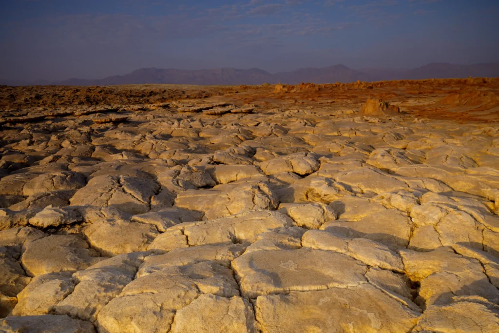
Before sunrise the salt plain gives nothing away. The Asale flats hold the night’s last coolness, and the only sound is the soft knock of wooden pack-frames as Afar men load slabs of rock salt onto camels and donkeys at the edge of the lakebed. Each block has been cut by hand with an axe and shaped to a standard size, the amole, a bar that once circulated as money across the Ethiopian highlands. The caravan forms in the dark because by mid-morning the air over the basin will pass 40 °C, and the ground, more than a hundred meters below the level of the distant Red Sea, will radiate heat like a stovetop. A few kilometers north, steam already drifts off a low salt dome stained acid yellow and rust red. That dome is Dallol, and the men have a word for it that means roughly “disintegration.”
What is the Danakil Depression
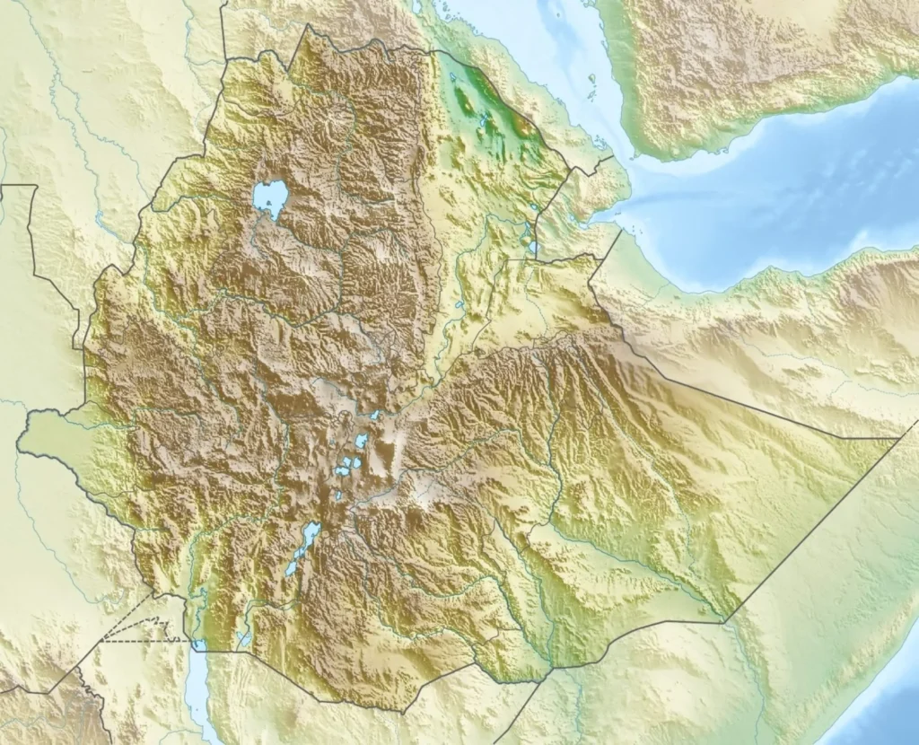
The Danakil Depression is a deep, salt-floored basin in the Afar Region of northeastern Ethiopia, straddling the border with Eritrea, sitting roughly 100 to 125 meters below sea level and ranking as the hottest place on Earth measured by year-round average temperature. Dallol is a volcanic feature near its northern end, a salt dome riddled with hot springs that discharge some of the most acidic, saltiest, iron-loaded water ever measured in nature. The two names get used loosely and sometimes interchangeably, but they describe different scales: Danakil is the basin, Dallol is one extraordinary spot within it.
The depression is one of the few places on land where you can stand on a continent in the act of tearing itself apart and watch a new ocean begin to form. Its acid pools have become a natural laboratory for the outer limits of life, with direct relevance to how we search for biology on Mars. And its salt has supported a human economy for well over a thousand years. The science here is genuinely contested in places, and the most dramatic numbers you’ll read elsewhere deserve scrutiny, so this article flags where measurements disagree rather than smoothing them over.
Where the Earth Is Pulling Apart: The Afar Triple Junction
Stand anywhere in the Danakil and you are standing on the Afar triple junction, the place where three of the planet’s tectonic plates, the Nubian (African), the Somali, and the Arabian, are separating from one another. NASA’s Earth Observatory puts it plainly in its feature “Curiosities of the Danakil Depression”: in northeastern Africa “the Earth is pulling apart at the seams,” thinning the crust as the plates diverge, and the land “will someday fill with water as a new ocean or great lake is born.”
Three rift arms meet here. The Red Sea Rift runs up between the Nubian and Arabian plates; the Gulf of Aden Rift separates the Arabian and Somali plates; and the East African Rift trends south for thousands of kilometers toward Mozambique. These are fingernail-growth speeds: GPS measurements show the Nubian and Somali plates diverging across the East African Rift at only about 6 to 7 millimeters a year, while the Red Sea is opening between Africa and Arabia faster, on the order of 15 to 20 millimeters a year in the south. McClusky and colleagues (2010) showed that this extension is partitioned along strike: north of about 16°N it is taken up almost entirely on the main Red Sea Rift, while at about 13°N it has transferred completely into the Danakil Depression. Slow as that is, over millions of years it has dropped the basin floor far below sea level and stretched the crust until it began to behave less like a continent and more like a nascent ocean floor.
Geophysical evidence supports that reading. Along the Erta Ale volcanic range to the south, the lavas are basaltic and the rock chemistry suggests continental crust is essentially absent beneath the range, a sign the Nubian and Danakil blocks have detached there and the rift has reached an advanced, near-oceanic stage. Much of the extension is taken up not by faulting but by magma forcing its way up through dikes. In 2005 a single dyking episode in the Manda-Hararo segment opened the ground dramatically, a real-time glimpse of the process that builds mid-ocean ridges, normally hidden under kilometers of seawater.
The International Union of Geological Sciences recognized exactly this in October 2022, when it named “The Danakil Rift depression and its volcanism” to its First 100 Geological Heritage Sites. The citation describes “the ongoing birth of an ocean witnessed through tectonics and volcanism in an extreme evaporite arid environment.” The aridity is what makes this legible: it strips away the younger sediments that would normally bury the geologic record, so the structures of continental breakup sit exposed at the surface.
The first modern scientific reconnaissance came late. A French-Italian expedition worked the area in the winter of 1967–68, just as plate-tectonic theory was maturing, and researchers quickly recognized the Afar as a textbook case. Enrico Bonatti compared the process to “the development of the proto-Atlantic by rifting of Pangea.” Arguments over the details, how much crust had thinned, whether true oceanic spreading had begun, filled the journals for years afterward, and some of them are not fully settled.
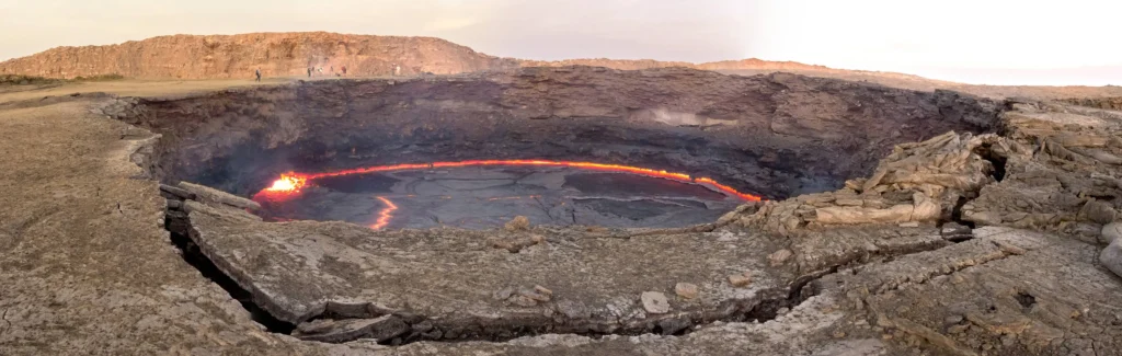
How Dallol Got Its Colors: Iron, Acid, and Jarosite
Dallol itself is young and strange. It rises only about 40 to 60 meters above the salt plain as a broad dome roughly 1.5 by 3 kilometers across, and despite the “volcano” label it has never built a classic cone. José M. López-García and colleagues, writing in Frontiers in Earth Science in 2020, reconstructed its history from three field campaigns and argued that the dome’s recorded story began when at least one deep basalt intrusion pushed up younger than 6,000 years ago, lifting and bulging the buried marine salt. They call it a “halo-volcanic complex” and a case of proto-volcanism, magma interacting with a thick evaporite pile rather than erupting through open rock.
The colors come from chemistry, not biology, and the distinction is the whole point. Eva Kotopoulou and colleagues, in ACS Earth and Space Chemistry (2019), laid out the mechanism in a paper titled “A Polyextreme Hydrothermal System Controlled by Iron.” Basaltic magma sits in a shallow chamber roughly 2.4 kilometers beneath Dallol. It heats groundwater and drives off acidic gases, carbon dioxide, sulfur dioxide, hydrogen sulfide, which combine with water percolating through the salt to produce brines that emerge at the surface around 108 °C, oversaturated in sodium chloride, essentially oxygen-free, and carrying a remarkable load of dissolved iron.
As that hot, ferrous-iron-rich fluid meets the air, oxygen diffuses in slowly and oxidizes the iron from Fe(II) to Fe(III). The iron complexes with chloride and sulfate, the brine evaporates, and a sequence of minerals precipitates over the halite crust. Kotopoulou’s team identified nanoscale jarosite-group minerals together with iron(III)-oxyhydroxides such as akaganeite, and hematite, painting the terraces in a progression from white through yellow, gold, orange, and finally rusty ochre. The same chemistry sculpts the bizarre architecture of the field, salt chimneys, miniature geysers, egg-shaped crusts, pillars, and lily-pad rims. Crucially, Kotopoulou and colleagues concluded that “life, if present, is not involved in the iron cycling and iron mineral precipitation at Dallol,” which sets it apart from famously colorful biological springs like Yellowstone’s Grand Prismatic.
How acidic is the water? This is where caution is warranted. Kotopoulou and colleagues reported pH values ranging from about 0.1 down to roughly −1.7. Felipe Gómez and colleagues, reporting in Scientific Reports the same year, described spring water at pH around 0, and recovered microbial structures from a salt chimney at pH 0.25. Jodie Belilla and colleagues, in Nature Ecology & Evolution, characterized the most extreme combination as pH near 0 at sodium-chloride saturation. Reported extremes vary between studies and sampling campaigns, ranging from roughly 0.25 down to below zero, and a single dramatic figure like “pH −1.7” should be read as the low end of one study’s range rather than a settled, universal value. The iron content is similarly eye-catching and similarly variable: Kotopoulou’s team cited up to about 150 grams per liter, while Gómez’s team measured 35.6 grams per liter of iron in the pools they sampled. Different springs, different days.
The Hottest Place on Earth
The settlement of Dallol once held a meteorological record that still gets quoted: the highest average annual temperature ever measured at an inhabited place. Between 1960 and 1966, when a mining outpost operated there, the mean annual temperature came out at 34.6 °C (94.3 °F), with an average daily maximum over that period of 41.1 °C (106 °F), figures so high because the heat barely relents at night or across the seasons. The highest temperature ever recorded at the settlement was 49 °C (121 °F). The town is now a ghost town, abandoned to the salt and the heat; the Dallol locality itself sits about 130 meters below sea level.
Several things conspire to bake the basin. It lies far below sea level, so air sinking into it compresses and warms. It sits in a rain shadow and receives only 100 to 200 millimeters of rain a year, with even less near the coast, so there is little moisture to moderate temperatures or cool the ground through evaporation. And it sits on top of an active geothermal and volcanic system, so heat rises from below as well as beating down from above. The result is a place where, as the salt miners know, the working day must start before dawn.
A note on competing claims: “hottest place on Earth” depends on what you measure. By long-term average air temperature at an inhabited location, Dallol’s 1960s record stands out. By single-day air-temperature extremes, the highest reliable reading belongs to Greenland Ranch in Death Valley, 56.7 °C (134 °F) on 10 July 1913. By satellite-measured ground-surface temperature, a NASA Earth Observatory analysis of MODIS land-surface data from 2002–2019 recorded peaks of 80.8 °C (177.4 °F) in both the Lut Desert of Iran and the Sonoran Desert. Each is a different metric, and Danakil’s distinction is the relentless year-round average rather than a one-off peak.
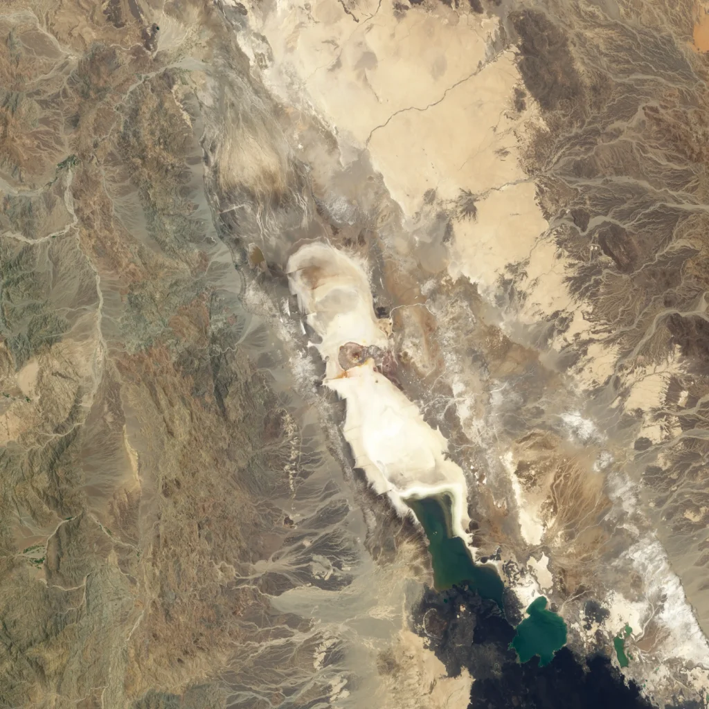
The parched floor of the Danakil Depression, where annual rainfall is measured in a few centimeters. Photo: Thomas Fuhrmann, Wikimedia Commons, CC BY-SA 4.0.
Life at the Edge: Is There Life in the Dallol Acid Pools?
For a long time the working assumption in microbiology was that wherever there is liquid water, life finds a way. Dallol has become the place where that assumption gets tested to destruction, and the literature genuinely disagrees about the answer.
On one side, Felipe Gómez and an international team reported in Scientific Reports (2019) the first evidence of life inside the hot springs themselves. From samples collected in January 2017 on a Europlanet-funded expedition, they described ultra-small microorganisms, cells just 50 to 500 nanometers across, up to twenty times smaller than an average bacterium, entombed in mineral deposits and assigned to the Nanohaloarchaea. Some were recovered from a salt chimney whose source fluid measured 86 °C at pH 0.25. The cells were often wrapped in needle-shaped crystals, hinting that they might play a part in mineral formation. If those organisms are truly alive and active there, Gómez argued, the limits of habitability on Earth, and the bar for what counts as a habitable Mars analog, both move outward.
On the other side, Jodie Belilla and colleagues, publishing in Nature Ecology & Evolution (2019) under the leadership of Purificación López-García, reached a more sobering conclusion after a larger and more carefully controlled survey. Combining 16S/18S rRNA gene metabarcoding, cell sorting, electron microscopy, and chemical analysis across the Dallol gradients, they argued that the most polyextreme pools host no active life at all, only occasional wind-blown dispersal forms. They identified two hard physicochemical barriers. The first is the combination of high chaotropicity and low water activity in magnesium- and calcium-dominated brines, where the salts literally pull apart the hydrogen bonding that biomolecules depend on. The second is the simultaneous hit of hyperacidity and salt saturation, pH near zero at sodium-chloride saturation, which they concluded is incompatible with the molecular adaptations life would need. López-García put it bluntly: liquid water alone does not make a place habitable.
That second paper also carried a warning that reaches well beyond Ethiopia. Belilla’s team observed that abiotic mineral structures at Dallol, silica-encrusted “biomorphs”, can mimic the size and shape of fossil cells, “raising warnings for the interpretation of morphological biosignatures on Earth and beyond.” In other words, a microscopic object that looks like a fossil microbe may be nothing of the kind, a caution that bears directly on how we’ll judge any cell-shaped feature returned from Mars.
The disagreement is partly about contamination control and partly about what counts as “life present” versus “life active,” and it has not been fully resolved. The most likely reconciliation is that the milder, merely-extreme brines around Dallol do host genuine archaeal communities, while the hottest, most acidic, salt-saturated pools appear to be sterile or very nearly so. Both camps agree the site marks a frontier. (For background, see our piece on [extremophiles and the origin-of-life debate].)
A Mars Analog: Why Dallol Is Called “Mars on Earth”
Barbara Cavalazzi and colleagues made the planetary case explicit in Astrobiology (2019), in a review titled “The Dallol Geothermal Area, Northern Afar (Ethiopia), An Exceptional Planetary Field Analog on Earth.” Their argument rests on the mineralogy as much as the extremity. The iron sulfates and oxides that paint Dallol, jarosite above all, are precisely the minerals NASA’s Mars rovers have been chasing.
When the Opportunity rover reached Meridiani Planum, its Mössbauer spectrometer detected jarosite and hematite in the sedimentary rocks there, reported by Göstar Klingelhöfer and colleagues in Science in 2004. Because jarosite is a hydrous iron sulfate that forms in acidic, water-bearing conditions, its presence was read as mineralogical proof that ancient Mars hosted acidic surface water, the same acid-sulfate, iron-driven chemistry running at Dallol today. The rover’s famous hematite “blueberries” belong to the same family of processes. Dallol offers a living version: a present-day site where scientists can watch jarosite and iron oxides precipitate from hot, acidic, briny water, and test how such deposits record, or destroy, evidence of life.
That last caveat is sharp. James Lewis, Mark Sephton, and colleagues at Imperial College London and the Natural History Museum showed, in two Astrobiology studies, that flash-heating jarosite, the very technique an instrument aboard the Curiosity rover uses to hunt for organics, decomposes the mineral and releases oxygen, which then oxidizes any organic molecules in the sample before they can be detected. If jarosite is present, in other words, a rover might incinerate the very biosignatures it is looking for before it can detect them. Dallol’s relevance is double-edged: it shows both what habitable-looking acid-sulfate chemistry produces and why reading life into it is treacherous.
There is a second, humbler analog lesson here. Earth’s most Mars-like ground is teaching planetary scientists, above all, how to be skeptical: if Dallol’s own biomorphs can fool a microscope, a cell-shaped feature returned from Mars deserves the same suspicion.
Beyond Dallol: Erta Ale, Gaet’ale, and the Salt Lakes
Dallol does not sit alone. Some 90 kilometers to the south rises Erta Ale, a basaltic shield volcano about 613 meters high that holds one of the longest-lived lava lakes on the planet, churning in its summit crater since at least 1906. The Afar call it the “smoking mountain,” and its southern pit has the local nickname “the gateway to hell.” Volcanoes with persistent lava lakes are rare, only a handful exist worldwide, and Erta Ale’s draws the same comparison to nascent mid-ocean ridge volcanism that the rest of the rift invites. For an instructive contrast in eruptive chemistry, the carbonatite volcano Ol Doinyo Lengai sits farther south along the rift in Tanzania, erupting lavas so cool and alkali-rich they run nearly black and white.
A few kilometers from Dallol lies Gaet’ale Pond, which holds a record of its own. E. Pérez and Yonas Chebude reported in Aquatic Geochemistry (2017) that its water carries about 433 grams of dissolved solids per kilogram, a salinity around 43 percent, making it the most saline natural water body known, saltier than Antarctica’s Don Juan Pond and far beyond the Dead Sea. Its chemistry is dominated by calcium and magnesium chlorides rather than table salt, and Fe(III) complexes tint it yellow. Sharad Master documented in 2016 that the spring, reactivated during the 2004–05 seismic crisis, leaks enough carbon dioxide to kill: birds and insects lie pickled and preserved around its rim, a quiet warning to visitors who get too close. Master flagged it explicitly as a tourist hazard.
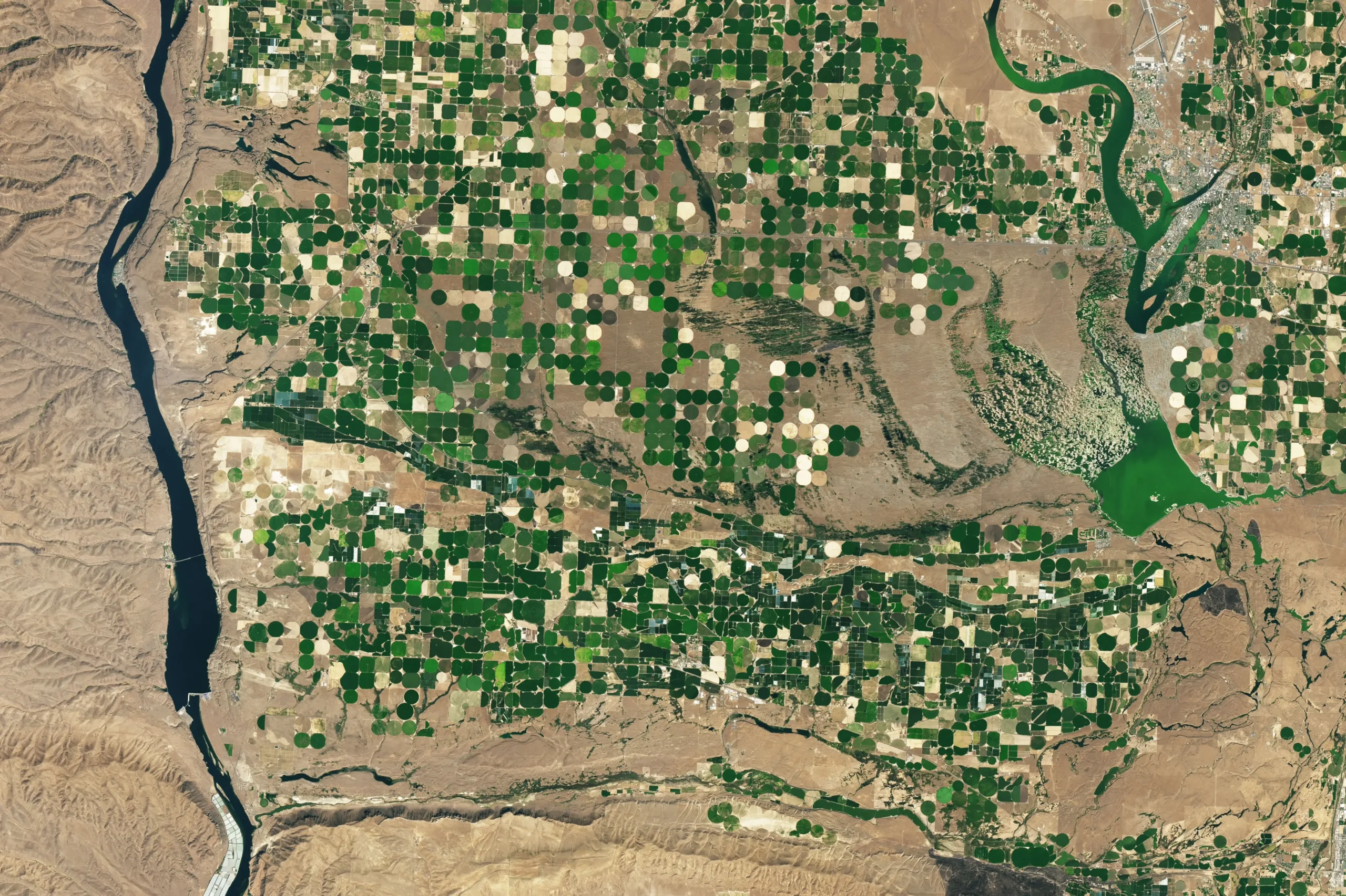
North and west of Dallol stretch the great salt lakes and flats, Lake Asale (also written Assale) and Lake Karum, vast pans of bedded halite hundreds of meters thick, laid down by repeated marine floods when the Red Sea broke into the basin during the Pleistocene and then dried out. The last separation from the sea is thought to have occurred roughly 30,000 years ago. These deposits are both the basin’s geological archive and its economic engine.
The Salt Caravans and the People of the Afar
The Afar have worked this basin for a very long time. NASA’s Earth Observatory notes they have survived here “for at least 2,000 years, mining and selling the plain’s abundant salt, which was once used as currency in Ethiopia,” and some historians trace the organized salt trade back to roughly the 6th century. The work is brutally simple and almost unchanged: men walk onto the dry lakebed, leave their camels at the margin, and split the crust open with axes and wooden poles, prying up slabs that are then trimmed into standardized bars.
Those bars, the amole, were genuine money for centuries, exchanged in highland markets far from the desert. A strong camel can carry on the order of 240 kilograms of salt; donkeys carry far less. The caravans once trekked four days up rock-strewn gullies to reach Mekele, the regional city. Wages are low and the labor punishing, one miner quoted by Agence France-Presse earned about 500 birr, roughly 22 US dollars, in a day’s offloading work.
Change is arriving fast. Around 2015, road builders connected the salt-trading town of Berhale to Mekele by tarmac, cutting the camel journey and shifting much of the haulage to trucks; about 5,000 salt blocks now reach Berhale’s trading post daily before continuing by road, some as far as Kenya. Mechanized evaporation plants have begun to appear. Some caravan drivers welcome the shorter trip; others see the writing on the wall for a trade their families have followed for generations. Whether the camel caravans survive the next decade as a working economy, rather than a tourist spectacle, is an open question.
The wider Afar region carries another distinction. Paleoanthropologists have recovered some of the most important early-hominin fossils in the world here, including “Lucy,” the 3.2-million-year-old Australopithecus afarensis found in 1974, and the older Ardipithecus ramidus (“Ardi”). Cavalazzi and colleagues note that the Afar can reasonably be called a cradle of humankind. The same restless tectonics that are pulling the continent apart also kept exposing and burying the lake-margin sediments where our ancestors’ bones were preserved.
Visiting Dallol: Safety, Tours, and Conservation
For most of the late twentieth century the basin was effectively closed to outsiders, between Haile Selassie-era isolation, the political turbulence after 1974, and the Ethiopia–Eritrea border conflict. The area opened to foreign visitors only around 2001, and tourism remains genuinely risky. In January 2012 an armed group attacked tourists at Erta Ale, killing five and taking two hostages; in December 2017 a German tourist was fatally shot on the volcano. Travelers in the region typically move in convoys with armed escorts arranged through tour operators, and trips run only in the cooler months, roughly November to March.
The physical hazards are as real as the security ones. Dallol’s ground can be a thin salt crust over scalding brine or a gas pocket; the springs sit above 100 °C; and the gases venting from the field and from Gaet’ale include enough carbon dioxide and hydrogen sulfide to be lethal in still air. The site is remote, with limited rescue capability and minimal monitoring, much of what scientists know about current activity comes from satellite thermal data and occasional field campaigns rather than continuous instruments.
Conservation is the quieter problem. The delicate salt and mineral architecture that makes Dallol famous is easily trampled, and the surge of visitors has already left visible damage and a growing scatter of plastic waste across one of the most fragile landscapes on Earth. The IUGS heritage designation gives the site international scientific recognition, but it carries no automatic legal protection on the ground, and Ethiopia has not yet given Dallol national-park status. Anyone going should treat the formations as irreplaceable, carry out everything they bring in, and follow Afar guides whose livelihoods and safety are bound up with the place.
Frequently Asked Questions
Where is the Danakil Depression and how far below sea level is it?
The Danakil Depression lies in the Afar Region of northeastern Ethiopia, extending to the border with Eritrea, at the northern end of the Afar Triangle. It sits roughly 100 to 125 meters below sea level; published figures vary because the basin floor is uneven and different sources measure different points, with some sampling sites cited as deep as 124–155 meters below sea level.
Why is Dallol considered a “Mars on Earth”?
Dallol’s hot springs precipitate jarosite, hematite, and other iron sulfates and oxides, the same minerals NASA’s Opportunity rover found at Meridiani Planum, which indicate ancient acidic water on Mars. Barbara Cavalazzi and colleagues (Astrobiology, 2019) describe Dallol as an exceptional planetary field analog because it lets scientists study that acid-sulfate, iron-driven chemistry, and the limits of life within it, on present-day Earth.
How acidic and hot are the Dallol pools?
The springs emerge near 108 °C, are saturated in salt, and are extremely acidic. Reported pH extremes vary between studies and sampling campaigns, ranging from about 0.25 down to below zero; Kotopoulou and colleagues (2019) reported values from roughly 0.1 to −1.7. A single figure should be treated as one study’s reading rather than a fixed value, because conditions differ from spring to spring and day to day.
Is there life in the Dallol acid pools?
It is genuinely contested. Felipe Gómez and colleagues (Scientific Reports, 2019) reported ultra-small Nanohaloarchaea in the hot springs. Jodie Belilla and colleagues (Nature Ecology & Evolution, 2019) concluded that the most extreme pools host no active life, identifying chaotropicity, low water activity, and combined hyperacidity-plus-salt as barriers. The likely reconciliation is that milder brines host microbes while the hottest, most acidic, salt-saturated pools are effectively sterile.
When did Dallol last erupt?
Dallol’s most recent confirmed eruption was a phreatic (steam-driven) explosion in 1926, which formed a small crater. The Smithsonian’s Global Volcanism Program records a degassing event in January 2011, and a 2004 dyke intrusion reactivated parts of the hydrothermal system, but there has been no recent magmatic eruption.
Can tourists visit, and is it safe?
Visits are possible, generally on guided convoys with armed escorts during the cooler months (about November to March). Risks include extreme heat, scalding and acidic water, toxic gases, unstable ground, and a history of attacks on tourists at nearby Erta Ale in 2012 and 2017. The area is remote with limited rescue capacity, so expert local guidance is essential.
Conclusion
The Danakil Depression is hard to summarize because it is doing too many things at once. A continent is splitting open here, slowly enough that the process which normally hides under kilometers of seawater lies exposed on the surface. The acid pools are still dividing microbiologists over whether anything lives in them. And the salt trade that has run for more than a thousand years is now being overtaken, within a single generation, by a tarmac road and a fleet of trucks. The numbers that make Dallol famous remain unsettled: the pH that may or may not dip below zero, the iron loads that differ from one spring to the next, the pools that one team calls sterile and another calls inhabited. That disagreement is not a gap in the reporting. It is what a place at the genuine edge of measurement looks like, and it is why researchers keep going back.