Introduction
Around forty-five volcanoes are erupting somewhere on Earth right now. A dozen of them never really stop.
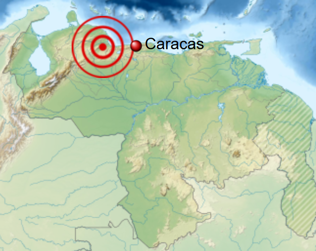
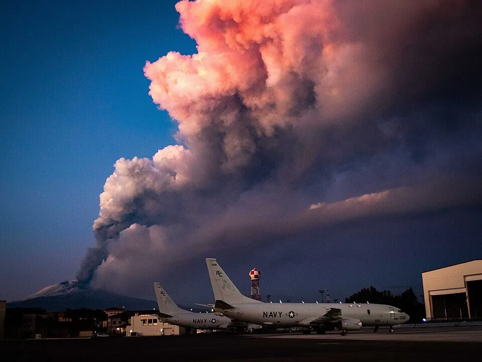
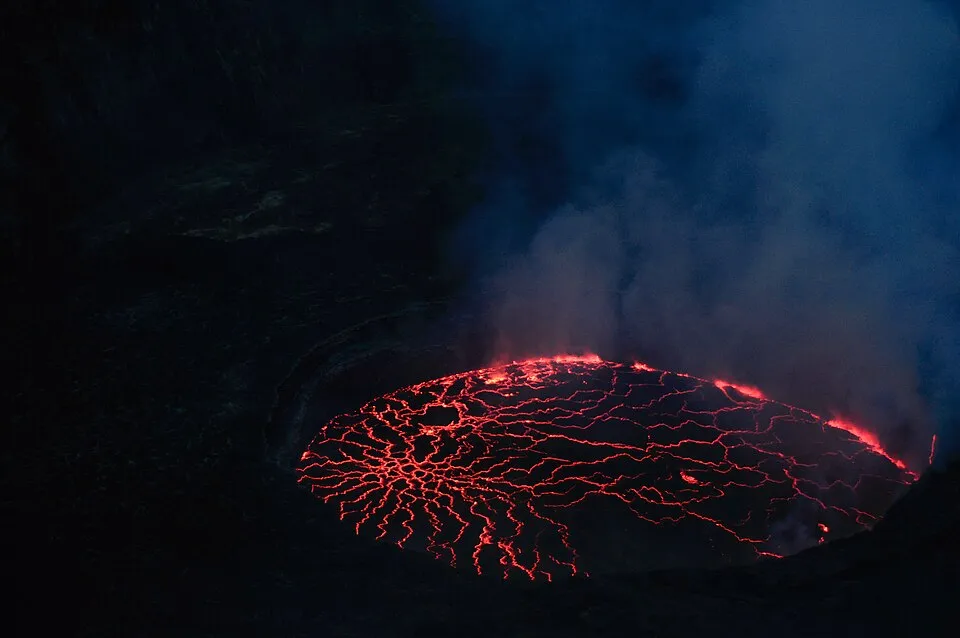
At 12:27 a.m. Hawaiʻi Standard Time on 15 May 2026, the lava fountain at Halemaʻumaʻu’s north vent collapsed. Episode 47 of Kīlauea’s current eruption had run for nine hours. Tiltmeter UWD, perched on the caldera rim at Uēkahuna, recorded 15.6 microradians of deflation as the summit shrank back toward itself. By dawn, only steaming flows remained on the crater floor. USGS Hawaiian Volcano Observatory staff dropped the alert level from WATCH to ADVISORY and began the next forecast: when, between bursts of tremor and gas-piston cycles every one to ten minutes, episode 48 would begin.
Kīlauea has been erupting in episodes like this one since 23 December 2024, days or weeks apart, the same twin vents reopening on the floor of the caldera that collapsed in 2018. The summit inflates over weeks, vents glow and flame, and then a fountain pulses skyward for a few hours before draining back. It is one of around a dozen volcanoes geologists describe as persistently active: open-system mountains whose plumbing stays primed for decades or centuries. A few host stable lava lakes that have glowed continuously for decades. Stromboli has erupted in short pulses every ten to twenty minutes for as long as anyone has kept written records. A few have buried cities within hours of giving warning.
The list of continuously erupting volcanoes is short and contested. These same mountains have produced most of what modern volcanology knows about how magma plumbing actually behaves at depth.
What “Active” Really Means in Volcanology
The Smithsonian Global Volcanism Program (GVP), the catalogue of record, built on the foundation of Siebert, Simkin and Kimberly’s Volcanoes of the World, 3rd ed. (University of California Press, 2010), defines an active volcano as one that has erupted within the Holocene, the last ~10,000 years. By that yardstick, Earth has roughly 1,500 known Holocene volcanoes on land. Around 40 to 50 erupt in any given year, and roughly 45 are in eruption at any moment.
“Historically active” usually means an eruption recorded in written sources. “Currently erupting”, GVP’s continuing eruption tag, requires sustained, observed activity for more than three months. A few volcanoes have held that tag for decades: Yasur in Vanuatu (since at least 1774, when Captain Cook saw it glowing), Stromboli in the Aeolian Islands (continuously for roughly two millennia, by GVP’s reading), Sakurajima in Japan (since 1955), and Santiaguito in Guatemala (since 1922).
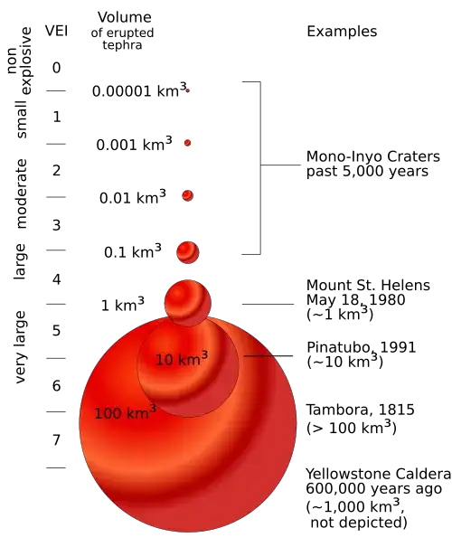
The Volcanic Explosivity Index, or VEI, devised by Chris Newhall and Steve Self in 1982, runs from 0 (effusive, non-explosive) to 8 (mega-colossal). It is logarithmic in erupted volume: each step is roughly ten times more material than the last. Most persistent activity sits at VEI 0–2. Kīlauea’s 2018 lower East Rift Zone eruption, which destroyed more than 700 structures and erupted approximately one cubic kilometre of basalt, was VEI 3 (Neal et al., 2019, Science). Merapi’s 2010 explosive crisis was VEI 4. Santa María’s 1902 Plinian eruption, the parent volcano of today’s Santiaguito dome, was a VEI 6 — one of the three largest eruptions of the 20th century, alongside the 1912 Novarupta blast in Alaska and the 1991 Mount Pinatubo eruption in the Philippines.
There is no single most active volcano, because the metric decides the answer. Stromboli erupts more days than anywhere else; Kīlauea and Klyuchevskoy move the most magma; Sakurajima’s Minamidake crater has logged more than 15,000 individual explosions since 1955; Merapi and Nyiragongo have killed the most people. Volcanologists tend to drop the ranking and talk about eruption styles instead.
Why Some Volcanoes Never Stop Erupting
Whether a volcano stays persistently active depends on how fast magma arrives, the shape of the conduit it travels through, and how much gas it carries. Supply has to roughly match what’s lost at the surface, and the conduit cannot sit idle long enough to seal.
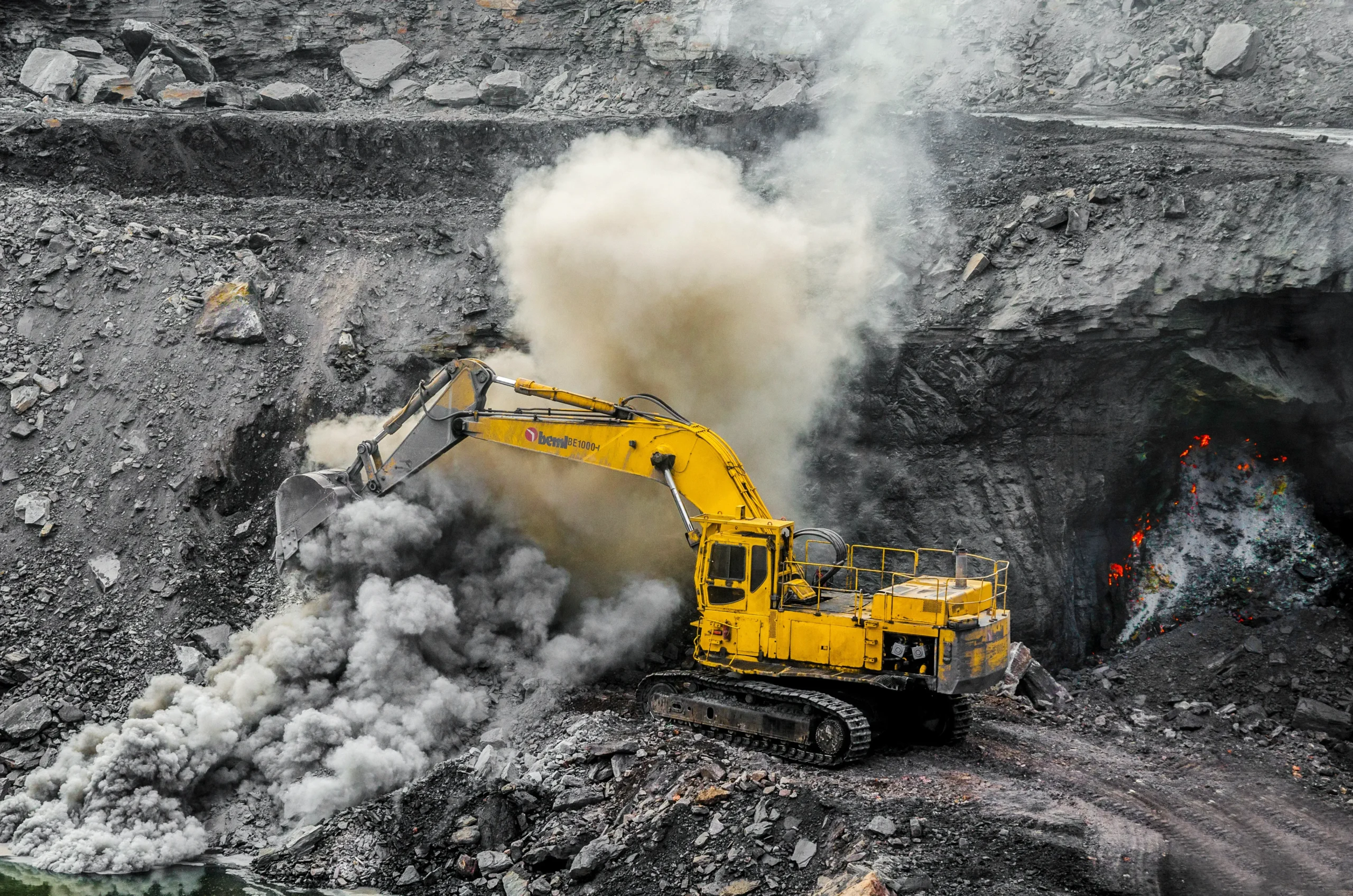
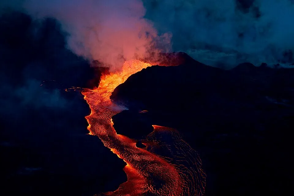
Hawaiian basalts arrive at Kīlauea’s summit reservoir at roughly 0.1–0.15 cubic kilometres per year, sourced from the Hawaiian mantle plume hundreds of kilometres below. The magma erupts at around 1150 °C with roughly 50 wt% SiO₂ — silica-poor enough to flow like motor oil. It rises through a vertical plumbing system that HVO seismologists have mapped down to individual dike segments. When pressure builds in the shallow reservoir 1–2 km beneath Halemaʻumaʻu, an eruption follows; when it bleeds off, the eruption pauses. The 2018 event, dissected by Patrick et al. (2020, Nature Communications 11, 5646), showed how a clog at the long-lived Puʻu ʻŌʻō vent drove magma 40 km down the East Rift Zone to Leilani Estates, then drained the summit so fast the caldera floor dropped over 500 m.
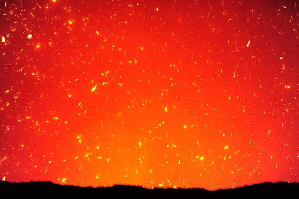
Volcanologists distinguish two regimes. In an open system, Stromboli, Erta Ale, Nyiragongo, Yasur, and Kīlauea between caldera-collapse cycles, an unobstructed pathway connects a shallow reservoir to the surface, and the system degasses continuously. Aiuppa and colleagues (Aiuppa et al., 2010, EPSL 295, 195–204) showed that Stromboli’s signature explosions every 10–20 minutes come from slugs of CO₂- and SO₂-rich gas rising from 2–3 km depth and expanding as they reach the surface. The individual bursts are small, the conduit never seals, and the lava sits at around 1100 °C.
A closed system behaves differently. The conduit chokes and seals between bursts, and pressure builds against thicker, gas-charged magmas, andesite or dacite at 800–950 °C with 56–66 wt% SiO₂, until something gives, usually as a Vulcanian explosion or a dome-collapse pyroclastic flow. Merapi, Sakurajima, Whakaari, and Santiaguito all work this way. The same mountain can run both regimes simultaneously: Etna combines persistent Strombolian degassing from its summit craters with paroxysms that throw fountains over a kilometre high.
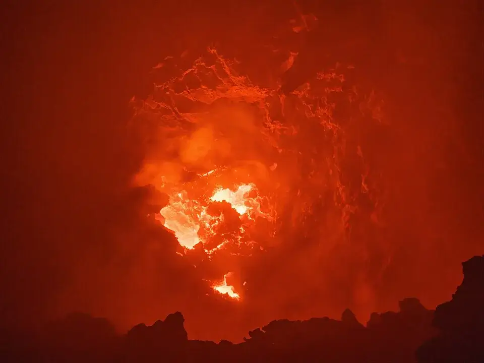
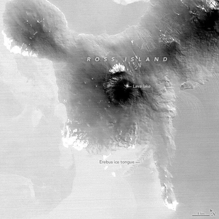
A rarer setup holds a persistent lava lake on the surface. Erta Ale in Ethiopia, Nyiragongo in DR Congo, Mount Erebus in Antarctica, Masaya in Nicaragua, Kīlauea between collapse cycles, and Ambrym in Vanuatu before its 2018 drainage have all hosted molten lakes for years on end. The condition is a knife-edge balance between shallow degassing and magma supply: the column never rises enough to overflow nor falls enough to crust over. Spampinato and colleagues’ thermal-camera and SEVIRI study (Spampinato et al., 2013, JGR Solid Earth 118, 5771–5784) measured peak temperatures of about 1180 K (≈907 °C) at upwelling sites in Nyiragongo’s lake and a radiant heat flux of around 1.1 GW.
The Tectonic Settings Behind Persistent Active Volcanism
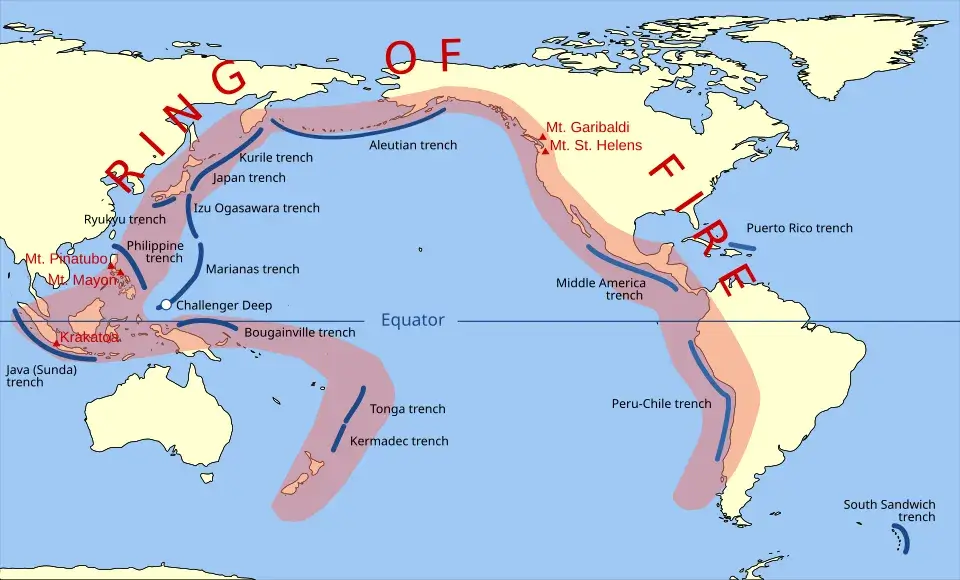
Most of Earth’s persistent volcanoes line the subduction zones. The Pacific Ring of Fire, the roughly 40,000-km arc where oceanic plates sink beneath continents and island arcs, hosts about three-quarters of them. Sakurajima rides the Philippine Sea Plate’s descent under southwest Japan. Merapi sits 4,500 km southwest, above the Sunda Trench where the Indo-Australian Plate dives beneath Java. Klyuchevskoy belongs to the Kamchatka arc, fed by the same Pacific slab from its northern end. Further south, Whakaari/White Island marks the head of New Zealand’s Taupō Volcanic Zone, and Yasur, on Tanna, sits above the more tangled geometry of the New Hebrides subduction zone, where the Indo-Australian Plate slides east beneath the Pacific.
Subduction magmas trend toward andesite and dacite. The descending slab releases water that triggers wet melting in the overlying mantle wedge, and the resulting melts come out silica-rich and gas-charged. That chemistry is what makes Ring of Fire volcanoes explosive, and what pushes their persistent activity toward dome growth and Vulcanian blasts rather than lava lakes.
Hotspots produce the second cluster. Kīlauea is the flagship: the southeasternmost member of the Hawaiian-Emperor chain, fed by a plume rooted near 2,900 km depth at the core-mantle boundary. Piton de la Fournaise, on Réunion, sits over the trailing tail of the Deccan plume that erupted some 65 million years ago. Hotspot basalts are hot, runny, and low in water; they build broad shields rather than steep stratovolcanoes.
A smaller group rises along continental rifts. The Erta Ale range, in Ethiopia’s Danakil Depression, marks the surface of the Afar Triple Junction, where the East African Rift meets the Red Sea and Gulf of Aden. Its magmas are tholeiitic basalts from shallow mantle melting under thinned crust, chemically similar to what erupts at mid-ocean ridges. Nyiragongo and Nyamuragira, in the rift’s western branch, erupt something stranger. Their ultramafic, alkali-rich, nearly silica-free nephelinites and melilitites are the lowest-viscosity lavas on Earth. Nyiragongo’s 2002 flank flows ran at up to 60 km/h, faster than a person can sprint.
Etna belongs to none of these cleanly. It rises at the convergence of the African and Eurasian plates, in a zone of arc-collision and possible slab rollback that volcanologists still argue about. Its magmas range from alkaline basalts to trachybasalts, and its persistent activity blends Hawaiian-style fountaining at the South-East Crater with subduction-style ash blasts. It is the largest active volcano in Europe and one of the most heavily instrumented mountains on the planet, with a dedicated INGV observatory in Catania.
The Fire Mountains Themselves: A Field Guide to the World’s Most Active Volcanoes
Kīlauea, Hawaiʻi
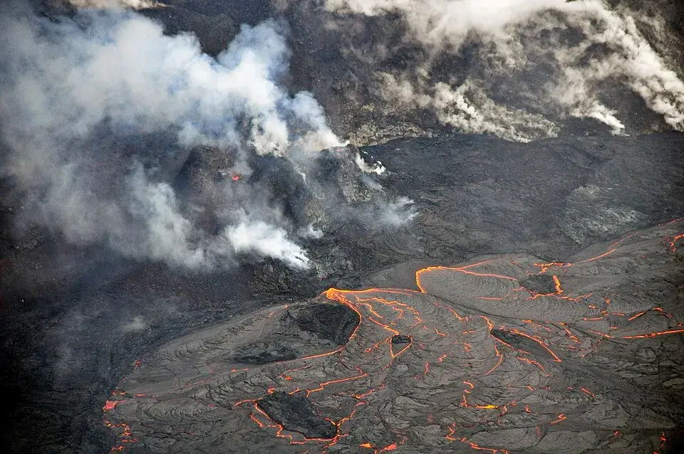
Location: Island of Hawaiʻi, 19°25′N. Tectonics: Hawaiian hotspot, oceanic shield volcano. Magma: tholeiitic basalt, ~1150 °C, ~50 wt% SiO₂. Kīlauea has been the most-studied volcano in the world since the Hawaiian Volcano Observatory opened in 1912. Its long Puʻu ʻŌʻō eruption ran from 1983 to 2018; the present summit eruption began on 23 December 2024 and continues in episodes of lava fountaining at the Halemaʻumaʻu vents, with episode 47 ending at 12:27 a.m. HST on 15 May 2026 (HVO Daily Update, 15 May 2026). Status as of May 2026: Alert ADVISORY, Aviation YELLOW. Signature event: the 2018 caldera collapse, in which the summit floor dropped about 500 m and M5+ collapse earthquakes occurred almost daily for two months.
Stromboli, Italy
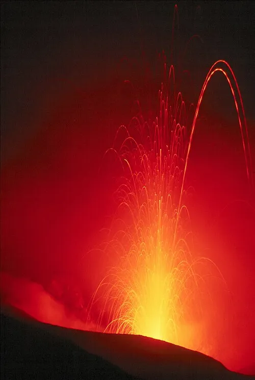
Location: Aeolian Islands, 38.79°N. Tectonics: subduction-related. Magma: shoshonitic basalt, ~1100 °C. Stromboli is the type locality for the Strombolian eruption, a style defined by short, mild explosions every 10–20 minutes from vents on a crater terrace 700 m above sea level. The current persistent eruption has continued for roughly two thousand years. In 2019 two paroxysms broke the rhythm: on 3 July, an explosion ejected about 6 × 10⁷ kg of bombs, lapilli and ash up to 6 km high and killed one hiker; a second followed on 28 August (Andronico et al., 2021, Nature Communications 12, 4213). Status as of May 2026: Alert Yellow (level 2 of 4); lava overflows from the North Crater area reached the coastline on 5 May 2026 (GVP Stromboli).
Mount Etna, Italy
Location: Sicily, 37.75°N, 3,357 m. Tectonics: arc-collision zone. Magma: alkaline basalt to trachybasalt. Etna’s written eruptive record reaches back to the 8th century BCE in Greek and Latin sources, with possible Bronze Age references several centuries earlier: among the longest for any volcano on Earth. Recent activity has concentrated at the South-East Crater complex, which produced dozens of paroxysms between December 2020 and February 2022 (Bonaccorso & Calvari, 2017, EPSL 475, 231–241). The 2026 eruptive year opened on 1 January with a fissure at ~2,050 m elevation in the Valle del Bove; lava flowed several kilometres east before the fissure went quiet in early February. INGV-OE volcanologist Boris Behncke has been one of the most visible chroniclers of Etna’s recent paroxysms. Status as of May 2026: persistent summit activity at Voragine and South-East craters.
Sakurajima (Aira Caldera), Japan
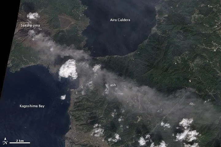
Location: Kyushu, 31.6°N, 8 km east of Kagoshima (population 680,000). Tectonics: Ryukyu subduction zone. Magma: andesite, ~57 wt% SiO₂. The Minamidake summit cone has been in essentially constant activity since 1955; between 1955 and 2024, observers logged 15,057 individual eruptions from the Minamidake and Showa craters. Average SO₂ emissions are around 2,000 tonnes per day, with measured peaks of about 2,800 t/d. Status as of May 2026: JMA Alert Level 3 (restriction on proximity). On 8 May 2026 a Vulcanian explosion at 16:15 JST produced an ash plume to 3.5 km above the crater rim, ejected blocks 1.3 km, and generated the first pyroclastic flow at Minamidake since 16 June 2018 (GVP Aira). Designated a Decade Volcano in 1991.
Erta Ale, Ethiopia
Location: Danakil Depression, 13.6°N, 613 m. Tectonics: Afar Triple Junction, continental rifting. Magma: tholeiitic basalt. Erta Ale’s lava lake has been intermittently active in the summit caldera since at least 1967, possibly since 1906. A 2017 flank fissure drained the lakes; subsequent activity has rebuilt intra-caldera vents and hornitos. Status as of May 2026: low-level intra-caldera activity, no persistent lake at present, multiple thermal anomalies in the north and south pit craters per Sentinel-2 imagery; the 23 November 2025 eruption of nearby Hayli Gubbi deposited ash across Erta Ale’s caldera.
Mount Yasur, Vanuatu
Location: Tanna Island, 19.5°S, 361 m. Tectonics: New Hebrides subduction zone. Magma: basalt to basaltic andesite. Yasur has been in continuous Strombolian to mild Vulcanian eruption since at least 1774, when Captain Cook saw its glow during his second Pacific voyage. Like Stromboli, it produces small explosions from two to three vents within a 400-m-wide crater. Status as of May 2026: VMGD Alert Level 2 (“major unrest”); 847 Strombolian explosions logged in March 2026; 600-m permanent exclusion zone in force.
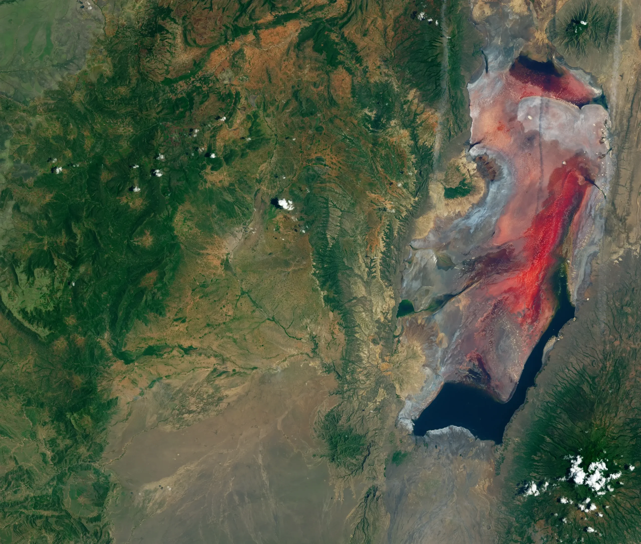
Nyiragongo, DR Congo
Location: Virunga chain, 1.5°S, 12 km north of Goma (population 2 million). Tectonics: western branch of the East African Rift. Magma: foiditic ultramafic alkaline lavas (nepheline, melilite, leucite). Nyiragongo has hosted one of the most voluminous lava lakes in modern history. The lake drained catastrophically on 17 January 2002, when a 13-km fissure split the southern flank and lava ran into Goma at speeds reported up to 60 km/h, killing at least 170 people and displacing approximately 350,000, most of them across the border into Rwanda (Tedesco et al., 2007, JGR Solid Earth). A second flank rupture on 22 May 2021 killed 32 and forced the evacuation of about 364,000 people. Status as of May 2026: persistent intra-crater lava lake activity has resumed; the Observatoire Volcanologique de Goma reports a second lake formed on the eastern crater floor in early 2024. Designated a Decade Volcano in 1991.
Piton de la Fournaise, La Réunion
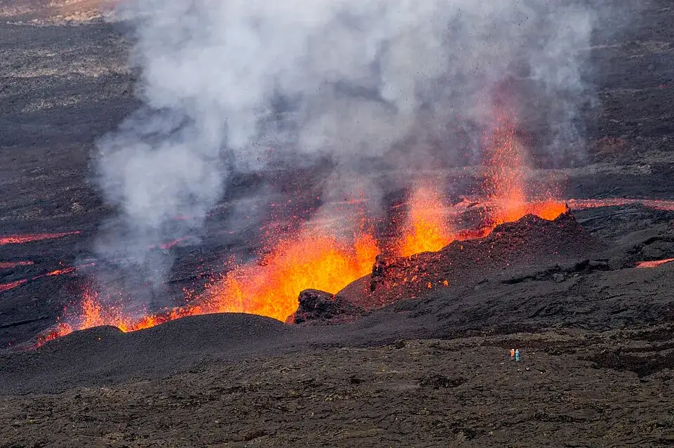
Location: Réunion Island, 21.2°S, 2,632 m. Tectonics: Réunion hotspot. Magma: basalt, ~1170 °C. One of the most frequently erupting volcanoes on Earth, about two eruptions per year since 1998. The 2026 eruptive cycle has been remarkable. After a brief eruption 18–20 January, a second eruption began at 10:00 LT on 13 February from fissures near the Dolomieu Crater, paused twice, and finally ended on 12 April after roughly 50 active days. OVPF director Aline Peltier reported a peak effusion rate of about 60 m³/s. Lava reached the ocean on 16 March, the first time in 19 years, building an 8.5-hectare lava platform; field teams measured fresh lava at 1100–1130 °C near the ocean entry. Total erupted volume between 29.9 and 36.7 million m³. The OVPF-IPGP daily bulletin showed continued deep deformation through mid-May 2026. Cyclic magma storage at depths of 5–15 km is described in Peltier et al., 2009, EPSL 270, 180–188.
Whakaari/White Island, New Zealand
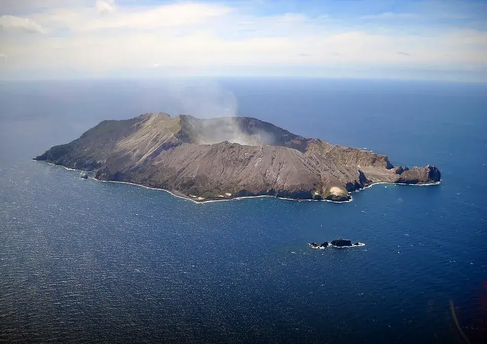
Location: Bay of Plenty, 37.5°S, 48 km offshore. Tectonics: Taupō Volcanic Zone, Kermadec subduction. Magma: andesite to dacite. Whakaari has been New Zealand’s most active volcano since 1976. On 9 December 2019 a phreatic eruption struck while 47 tourists and guides were on the island; 22 people died and 25 were injured, mostly from severe burns. The eruption involved no fresh magma, it was driven by superheated hydrothermal fluids, the same mechanism implicated in the volcano’s 1914 sulfur-mining disaster (Field et al., 2012, JVGR). Status as of May 2026: GeoNet Volcanic Alert Level 2, Aviation Yellow as of 7 April 2026, after a brief minor eruption on 24 March produced an ash plume to 1,300 m above the vent.
Mount Merapi, Indonesia
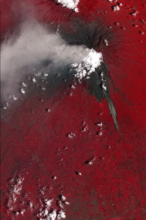
Location: Central Java, 7.5°S, 25 km north of Yogyakarta (population 3 million). Tectonics: Sunda subduction zone. Magma: basaltic andesite, ~58 wt% SiO₂, ~950 °C. Merapi has killed 3,000–5,000 people since 1672, more than almost any other volcano. The deep magmatic system, with reservoirs at roughly 9–13 km and shallower storage feeding the summit dome, was reconstructed from long-period earthquake locations and seismic tomography in the 1990s and early 2000s (Ratdomopurbo & Poupinet, 1995, GRL 22; Wagner et al., 2007, JVGR 161). The 2010 VEI 4 eruption killed nearly 400 people and displaced more than 300,000. The current effusive eruption phase began on 4 January 2021, after BPPTKG raised the alert level to Siaga (level 3 of 4) on 5 November 2020. Status as of May 2026: BPPTKG/PVMBG Alert Level 3 of 4 (“Siaga”); the south-west dome volume was measured at 4,026,700 m³ on 14 May 2026 after losing ~10,800 m³ to lava avalanches; 1,264 volcanic earthquakes recorded in the week of 8–14 May. Head of BPPTKG Agus Budi Santoso confirms magma supply continues. Designated a Decade Volcano in 1991.
Klyuchevskoy, Russia
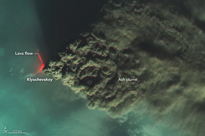
Location: Kamchatka Peninsula, 56.06°N, 4,754 m, the highest active volcano in Eurasia. Tectonics: Pacific Plate subducting under the North American Plate. Magma: basalt to basaltic andesite. Klyuchevskoy alone produces a magma flow of about 60 million tonnes per year, half of all that is produced by the intensely active 70-volcano Kuril-Kamchatka region, per the UNESCO Volcanoes of Kamchatka World Heritage datasheet. After a major eruption in April–August 2025, intensified after the 30 July 2025 M8.8 Kamchatka earthquake offshore, the summit explosive-effusive activity peaked in early August with ash to around 9 km above sea level and lava feeding the Bogdanovich Glacier. The eruption ended on 16 August 2025; aviation colour was lowered to Green on 25 September 2025 (GVP Klyuchevskoy, KVERT bulletins). Status as of May 2026: fumarolic only, Green.
Santa María / Santiaguito, Guatemala
Location: western Guatemala, 14.76°N, 3,772 m. Tectonics: Middle America subduction zone. Magma: dacite. The 1902 VEI 6 Plinian eruption of Santa María was one of the three largest of the 20th century, alongside the 1912 Novarupta blast in Alaska and the 1991 Mount Pinatubo eruption. Since 1922, dacitic dome extrusion at the Santiaguito complex (Caliente, La Mitad, El Monje, El Brujo) has been nearly continuous. Status as of May 2026: ongoing block-and-ash flows from Caliente Dome; INSIVUMEH reported pyroclastic density currents extending to the base of the dome and ash dispersing as far as 100 km west-southwest from 28 April 2026 onward. Up to four explosions per hour on 3–4 May 2026, plumes to 800 m above the vent.
Lava Lakes: Earth’s Open Windows
Of the planet’s roughly 1,350 active volcanoes, fewer than ten have ever held a stable surface lava lake for years on end. The current short list: Erta Ale (intermittently since 1906), Nyiragongo (with two long-lived stable periods, 1928–1977 and 1982–2002, plus the present refilling phase), Mount Erebus in Antarctica (since at least 1972), Masaya in Nicaragua (intermittent), Kīlauea between collapse cycles, and Ambrym in Vanuatu (until the December 2018 drainage).
A lake requires a thermodynamic steady state. Magma must arrive in the conduit at exactly the rate it cools, crystallises, and degasses out the top. If magma supply outpaces losses, the lake overflows or migrates to a flank vent; if it slows, the surface crusts over and the system shuts down. Burgi and colleagues’ multi-year reconstruction of Nyiragongo’s lava lake levels from 1,703 satellite radar images between the 2002 and 2021 flank eruptions tracked the lake refilling metre by metre, in full view of Goma’s two million residents.
Researchers can sample volcanic gases directly with multi-GAS instruments mounted on drones, measure radiant heat flux (Nyiragongo’s lake puts out around 1.1 GW), and time the cycles of bubble bursts to infer conduit geometry. At Erebus, infrasound microphones detected gas slugs the size of houses. At Masaya, ultraviolet camera networks tracked SO₂ flux variations correlated with lake convection cycles. Much of the modern theory of how degassing controls eruptive style, from Aiuppa’s Stromboli model to the open-vent paradigm now being applied to Hawaiian summit eruptions, was learned by watching lava lakes.
The French volcanologist couple Maurice and Katia Krafft, both from Alsace, who filmed lava lakes from closer than anyone before or since, were killed by a pyroclastic flow at Unzen, Japan, on 3 June 1991, alongside American volcanologist Harry Glicken and forty other people. Haroun Tazieff, the Belgian-French volcanologist who first descended into Nyiragongo’s lake in 1959, lived to old age. The difference, he said, was knowing when to leave.
Living in the Shadow of Active Volcanoes
An estimated 800 million people live within 100 km of an active volcano in 86 countries and additional overseas territories worldwide, according to the Cambridge / USGS volume Global Volcanic Hazards and Risk (Sparks et al., eds., 2015). Most accept the trade-off because volcanic soils are extraordinarily fertile and because their grandparents accepted it.
Goma, on the northern shore of Lake Kivu, sits 12 km south of Nyiragongo. The 17 January 2002 eruption sent lava flows through the city centre: a 60-m-wide swath of advancing basalt that destroyed about 14,000 homes, killed roughly 170 people (most in a petrol-station explosion on 21 January when residents tried to siphon fuel from a tanker the lava had reached), and forced approximately 350,000 to flee, mostly into Rwanda. The May 2021 eruption killed 32 and triggered the evacuation of about 364,000 (ECHO/OCHA situation reports). Dario Tedesco, the volcanologist at Università della Campania Luigi Vanvitelli who has monitored Nyiragongo since the mid-1990s, has called it “the most dangerous volcano in the world.” The Goma Volcano Observatory’s funding has been precarious since the World Bank ended its contributions in 2020; the M23 rebel movement has held parts of the volcano’s slopes since 2023.
Kagoshima, across the bay from Sakurajima, lives with ashfall the way other cities live with rain. Children walk to school wearing helmets. Cars carry plastic covers. The city runs evacuation drills for the 1914-scale eruption that destroyed most of the surrounding villages and bridged the island to the mainland with lava. Catania, beneath Etna, periodically closes its airport when ash plumes drift south. On Stromboli, fewer than 500 year-round residents share an island whose paroxysms can throw incandescent bombs into village streets.
The 9 December 2019 phreatic eruption at Whakaari was a different kind of failure: a tourism industry operating on an actively unstable hydrothermal system that gave no magmatic warning before it killed. The eruption produced no major magmatic precursor; vent temperatures had climbed to 746 °C in early 2020, but the actual blast came from steam-driven flashing of superheated hydrothermal water with no fresh magma intrusion. The 47 people on the island had no warning. Twenty-two died. On 31 October 2023, Auckland District Court Judge Evangelos Thomas convicted Whakaari Management Limited (WML); on 1 March 2024 six defendants were ordered to pay a combined NZ$10.21 million in reparations and NZ$2 million in fines. On 28 February 2025, High Court Justice Simon Moore quashed WML’s conviction, ruling that the landowning entity did not manage or control the island as a workplace under the Health and Safety at Work Act; the reparations and fines against the tour operators and helicopter companies remain in force. The case has reshaped landowner liability questions in volcano-tourism regulation.
What Continuous Eruption Reveals About Earth’s Interior
The 2018 Kīlauea sequence stands as the most thoroughly documented eruption ever recorded, and the reason is structural: at a persistently active volcano, the monitoring network never stops collecting.
HVO’s seismic, GPS, tilt, gas, and thermal networks recorded every step of that sequence — from the first Puʻu ʻŌʻō pressurisation through the lower East Rift Zone fissure opening to the 62 caldera collapse events. From those data, researchers (Neal et al., 2019) inferred that Kīlauea’s shallow magma reservoir sits about 1–2 km beneath Halemaʻumaʻu, that it is connected to a deeper reservoir at 3–5 km, and that the East Rift Zone conduit extends roughly 40 km laterally. Each caldera collapse earthquake reflected a piston-like drop of the summit floor as magma drained out the rift. Andrea Llenos and Andrew Michael of the USGS Earthquake Science Center subsequently developed forecast models that anticipate similar caldera-collapse seismicity in future events.
At Stromboli, Aiuppa and colleagues’ integration of gas geochemistry with seismic and acoustic data established that the persistent normal explosions originate from gas slug coalescence in the upper few kilometres of the conduit. Andronico and the INGV-Catania group’s 2021 analysis of the 2019 paroxysms (Nature Comm. 12, 4213) showed that paroxysms are preceded by weeks-to-months of subtly elevated normal activity: a destabilisation signal the monitoring system can now detect.
At Nyamuragira, Nyiragongo’s shield-volcano neighbour, Smets and colleagues’ multidisciplinary monitoring (Smets et al., 2014, Bull. Volc. 76, 787) reconstructed magma supply rates by combining InSAR, satellite thermal data, and Goma Volcano Observatory seismics: a method now standard for monitoring poorly accessible volcanoes worldwide. Voight’s seismic-tomography study at Merapi resolved the volcano’s deep plumbing for the first time, and the result still anchors Indonesian volcano observatories’ hazard analysis.
These mountains keep revealing plumbing far more tangled than the textbook diagram of one chamber feeding one pipe. The systems extend tens of kilometres into the crust, and for hotspots all the way to the lower mantle, through stacked reservoirs, dikes, and storage zones. Persistent eruptions are the only sustained data stream we have from those depths.