Earthquakes and volcanic eruptions claim thousands of lives each year. These disasters announce themselves with tremors, but the truly critical signals – the subtle warnings that precede catastrophe – have remained largely invisible to human observers until recently.
Artificial intelligence now captures millions of micro-tremors that scientists previously dismissed as background noise. Seismology is shifting from simply recording disasters to actually predicting them using massive new datasets. This way seismology turns from an observational science finally into a more predictive one.
This article explores how AI reads the Earth’s whispers, examines real-world cases where the technology prevented catastrophe, and looks at both the significant advances and honest limitations of this revolutionary approach to disaster prediction.
Enhancing seismic visibility with AI for clearer imaging
Traditional seismology captures only the most significant tremors. Imagine watching a film with 99% of its frames deleted – you would grasp the general plot but miss every subtle gesture, every quiet moment of foreshadowing that makes the story coherent.
Modern AI systems process continuous data streams from thousands of sensors simultaneously. The result? Standard monitoring basically ignores the small stuff. It’s like trying to understand a conversation while only hearing every tenth word—you get the gist, but you miss the context.
Micro-seismicity – those tiny tremors once dismissed as geological static – contains valuable patterns. AI algorithms extract, analyze, and translate these patterns into meaningful forecasts, finding signal where humans saw only noise.
The system distinguishes between background tremors in hard, crystalline igneous rocks like granite and subtle shifts in softer, layered sedimentary rocks. It identifies the unique seismic signature of stress building in metamorphic rocks, those formations altered by heat, and pressure deep underground. This high-definition view reveals how seismic waves propagate differently through dense basalt versus porous sandstone.

AI can now map the extent of different rock families – igneous, sedimentary, and metamorphic – by analyzing how micro-tremors travel through them.
Each rock type speaks its own seismic language, and artificial intelligence has finally learned to listen.
Improving noise into seismic maps
The main reason this works lies its ability to solve complex wave equations that transform seemingly random vibrations into coherent maps of subsurface activity. The math is staggering. These are computational feats that would take human analysts months to perform on even a fraction of the available data.
Unlike human analysts who might miss subtle correlations across disparate datasets, machine learning algorithms identify patterns across millions of data points from different locations, and timeframes simultaneously. These algorithms essentially perform mathematical time travel, working backward from recorded tremors to determine their precise origins within previously unmapped fault structures.
Neural networks trained on historical earthquake data learn to distinguish between harmless background noise and the characteristic signatures of building tectonic stress. The algorithms account for the physical characteristics of different rock types – the hardness of granite, the layered nature of shale, and the density variations between heavy basalt and lighter chalk.
To create increasingly accurate subsurface maps, the AI models wave propagation through materials with different densities. It learns the difference between the “clastic” signature of fragmenting sedimentary rocks – those built from compacted grains – and the “crystalline” signature of fracturing igneous rocks with their interlocking mineral structures.
This process resembles how a geologist might use a streak test to reveal a rock’s underlying composition.
What happens next? Well, the AI streaks the data – revealing the exact signature of rock formations under stress. It differentiates tectonic stress from vibrations caused by magma movement, an important distinction in volcanic regions dominated by igneous formations.
Taiwan 2024 – mapping the miracle
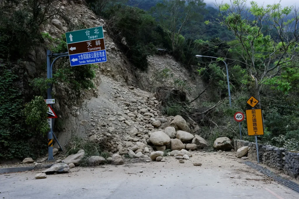
Taiwan Earthquake landslide by Reuters
In early 2024, following concerning tremor patterns, artificial intelligence systems mapped previously unknown fault structures beneath Taiwan in just 24 hours. Human teams would have required several months to accomplish the same task using conventional analysis methods.
The AI-generated maps revealed dangerous stress accumulation patterns completely invisible to traditional monitoring. Emergency officials credited the rapid assessment with saving hundreds of lives through targeted evacuations before a significant 6.2-magnitude earthquake devastatingly hit the region.
The Taiwan case showed the world how artificial intelligence can detect danger signs weeks earlier than conventional methods – dramatically extending the precious window for emergency preparations.
But perhaps most tellingly, post-event analysis confirmed that traditional monitoring systems had recorded the warning signals but lacked the analytical capacity to recognize their significance.
The AI identified previously unknown fault lines hidden beneath layers of compacted sedimentary rock. It pinpointed stress accumulating at the boundary between a hard igneous intrusion, softer surrounding strata, and precisely the kind of geological interface where catastrophic failures often initiate.
The system differentiated between microseismic noise from coastal sedimentary basins and critical signals from deeper metamorphic formations.
Because of the region’s complex geology – featuring a chaotic mix of metamorphic, igneous, and sedimentary zones compressed together by tectonic forces – this rapid mapping provided essential insights.
Inside the AI seismic brain
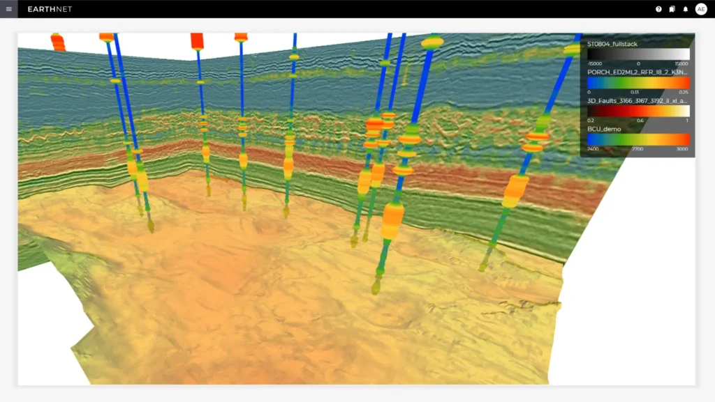
Photo by Earth Science Analytics
Today’s seismic AI systems employ sophisticated deep learning architectures, particularly convolutional neural networks that excel at pattern recognition across massive multi-dimensional datasets. Now, these aren’t necessarily static programs following rigid rules – they are learning systems that continuously retrain themselves with each new tremor, effectively becoming more accurate with every single earthquake or volcanic event they monitor worldwide.
Rather than working with simplified models of Earth’s structure, AI incorporates real-world complexities and irregularities that have historically made accurate forecasting nearly impossible. The AI trains on data from thousands of past events, learning the distinct failure patterns of different rock types – brittle slate versus granular sandstone, crystalline granite versus foliated schist.
It incorporates data on rock hardness, similar to principles geologists use with the Mohs scale, to predict how different formations will fracture under stress. The models learn to recognize the subtle seismic precursors that indicate stress changes deep within igneous plutons, like those massive underground formations found beneath Dartmoor or the Scottish Highlands.
When waves are absorbed or reflected, the AI can infer the presence of features like fossils, gas pockets, or sedimentary layers – features that affect stability in ways that matter during seismic events. The system’s neural networks prove particularly adept at identifying the foliated or banded patterns in seismic data that correspond to metamorphic rock formations, those ancient stones transformed by heat and pressure into new configurations.
Predicting volcanic eruptions before visual signs
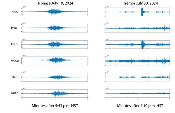
Volcanoes ‘whisper’ through distinctive micro-seismic patterns days or weeks before showing visible signs of activity. Artificial intelligence systems now routinely decode these communications, detecting the subtle seismic signatures of magma movement long before it approaches the surface.
While traditional methods that wait for physical changes like ground deformation or increased gas emissions, artificial intelligence catches the earliest tremors. Recent evacuations in Iceland, Indonesia, and the Philippines were triggered by artificial intelligence warnings issued before conventional monitoring systems detected actionable threat levels.
The technology shows particular promise for ‘silent’ volcanic threats – situations where gases, pressure, and build up without obvious external indicators until catastrophic failure occurs. Artificial intelligence systems prove particularly effective in volcanic regions dominated by igneous rocks like basalt and granite, as these materials have predictable fracture patterns when subjected to rising temperatures and pressures.
The technology tracks the movement of magma through underground channels, identifying how it fractures and melts existing rock formations. In places like the Isle of Skye or Giant’s Causeway – regions famous for their columnar basalt formations – artificial intelligence could analyze tremors within the ancient basalt columns to predict renewed volcanic activity.

It detects subtle changes in gas pressure that cause micro-fractures in the overlying rock, a key precursor to an eruption. The artificial intelligence distinguishes the low-frequency tremors of moving magma from the high-frequency snaps of cooling igneous rock, separating the truly dangerous signals from the routine sounds of geologically active terrain.
Expanding the warning timeline for better preparedness
Traditional earthquake early warning systems provide seconds to minutes of notice – barely enough time to take cover – while artificial intelligence–based forecasting aims for days to weeks of advance warning. This expanded timeline makes possible previously unthinkable preparation measures: controlled power grid shutdowns, hospital evacuations, and strategic resource positioning before disaster strikes.
Early detection through micro-seismicity analysis allows communities to transition from mere emergency response to genuine disaster prevention with dramatically reduced casualty rates. To create more targeted evacuation strategies, planners need to understand the specific failure point of local geology – whether it’s layered sedimentary rock or a solid igneous mass.
This allows for preemptive reinforcement of infrastructure built on less stable ground, such as areas with soft sandstone, or shale. Water and utility pipelines running through known fault zones in sedimentary basins can be shut down in advance to prevent secondary disasters like flooding, or gas explosions.
Emergency services can preposition heavy rescue equipment near areas identified as having high-risk metamorphic or igneous formations prone to catastrophic failure. However, the difference between responding after the fact and preparing in advance often measures out in lives saved and communities preserved.
Unexpected Applications of Seismic Technology
The same AI techniques revolutionising earthquake prediction have found surprising applications far beyond disaster forecasting. Technology developed to save lives during natural catastrophes now protects infrastructure, optimises energy production, and prevents industrial accidents.
Where Seismic AI is Making a Difference
Infrastructure Monitoring
AI systems now monitor bridges, dams, and buildings for developing structural weaknesses. Micro-fractures that would eventually lead to catastrophic failure get detected years in advance – when repairs are still straightforward and affordable.
Geothermal Energy
Energy companies use similar algorithms to optimise geothermal extraction whilst minimising induced seismicity risks. The AI predicts which underground operations might trigger earthquakes and adjusts drilling parameters accordingly.
Mining Safety
Underground mining operations deploy micro-seismic AI to predict tunnel collapses before they occur. The technology has already prevented numerous accidents by detecting subtle changes in rock stress distribution around excavation sites.
Construction Planning
AI monitors foundation settling on different substrates – from solid granite bedrock to compressible clay and mudstone. It helps map subsurface limestone caves and voids that could pose risks to new construction, preventing sinkholes before buildings appear above them.
Dam Safety
Water management authorities monitor the stability of dams built on or with sedimentary rocks, which can erode over time. AI tracking of micro-seismic activity reveals developing weaknesses before visible cracks appear.
Carbon Capture Monitoring
Projects injecting CO2 into underground storage formations use AI seismology to ensure stored carbon remains safely contained. The system detects any micro-fractures that might allow leakage, providing early warning long before environmental damage occurs.
Each application demonstrates how technology developed for one purpose often finds unexpected utility elsewhere – turning disaster prevention tools into everyday safety systems.
Current challenges and limitations of AI seismic forecasting
Despite impressive advances, AI seismic forecasting still struggles with certain geological contexts where tremor patterns differ significantly from training data or where sensor coverage remains sparse. False positives – predicted events that never materialize – create significant social and economic disruption, requiring careful balancing of sensitivity, precision, and reliability in AI systems.
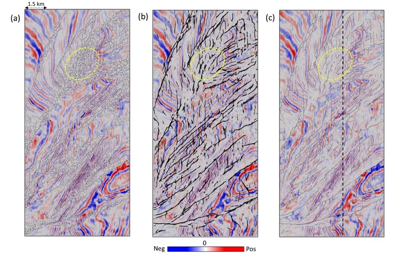
AI Application to Seismic Fault Interpretation
Many developing nations with high seismic risk lack the dense sensor networks, computational infrastructure, and technical expertise needed to implement these life-saving AI systems effectively. Given this, the technology raises complex ethical questions about responsibility when predictions fail or when warnings create panic despite scientific uncertainty about timing and magnitude. This poses some critical questions:
- Who bears responsibility when an AI-predicted earthquake never arrives, but evacuations have already disrupted thousands of lives?
- What happens when the technology that could save lives remains accessible only to wealthy nations whilst earthquake-prone developing regions continue operating blind?
- And perhaps most troubling: how do we balance the moral obligation to warn communities against the risk of causing panic over events we can predict in timeframe but not with absolute certainty?
AI’s predictive accuracy can be lower in geologically complex ‘mélange’ zones where sedimentary, igneous, and metamorphic rocks are jumbled together by tectonic forces. Areas with extensive soft sedimentary deposits, like river deltas, can dampen micro-seismic signals, making them harder for the AI to detect and interpret.
An AI trained primarily on data from subduction zones with igneous activity may perform poorly in continental rift zones dominated by sedimentary basins. False alarms can be triggered by non-tectonic events, such as the collapse of underground limestone caverns, large-scale quarrying operations, or other activities that mimic the seismic signature of natural tremors.
Quantum-enhanced seismic AI for the next generation
Emerging quantum computing applications promise to solve complex wave equations exponentially faster, potentially pushing prediction windows from weeks to months for major events. Next–generation seismic sensors with dramatically increased sensitivity will feed AI systems with even more detailed micro–tremor data from previously inaccessible depths.
Satellite–based measurements of ground deformation combined with traditional seismic data will create multi–modal AI systems capable of detecting preparation stages of major events.
Machine learning models are beginning to incorporate factors beyond seismicity alone – including groundwater changes, electromagnetic signals, and gas emissions – for more accurate predictions.
Quantum computers could model the behavior of individual mineral grains within a rock under stress, a level of detail currently impossible with classical computing. Next–generation systems will integrate real–time chemical analysis of groundwater, detecting changes caused by rock fracturing deep underground – changes that occur before the fractures grow large enough to generate detectable tremors.
A safer future, written in micro-tremors
The planet gives off signals long before a major quake; we’re finally getting better at recognizing them before the damage starts.
AI-driven seismology represents one of the most significant advances in disaster science – potentially saving thousands of lives annually as implementation expands globally. The technology transforms invisible micro-tremors into actionable intelligence, giving communities precious time to prepare for events that were once considered unpredictable.
The Earth will continue shaking. Volcanoes will continue erupting. These are all geological realities we simply cannot change. But what we can change is how we respond – we can listen to the whispers instead of low-magnitude seismic signals
AI seismology offers humanity a rare gift: advance notice of impending disaster. Whether that gift saves lives depends entirely on what we choose to do with it.
The data is there, and for the first time, we’ve the tools to actually use it. The challenge now is getting this technology into the regions that need it most.
Want to stay informed about technological breakthroughs reshaping our relationship with the planet? Visit the Geoscopy Instagram for more insights into Earth science, geology, and life-saving innovations.