


Introduction
The deepest blue hole in the world sits under a few meters of murky, brackish water about 4.5 kilometers off a fishing town on Mexico’s Caribbean coast, and no one has ever touched its floor. Its name is Taam Ja’, “deep water” in Yucatec Maya, and in December 2023 a probe lowered on a cable sank past 400 meters into the dark without finding a bottom. On one descent the instrument logged 416.0 meters below sea level. On a second, it reached 423.6 meters. Both times it ran out of cable, nerve, or patience before it ran out of hole. That makes Taam Ja’ the deepest known underwater sinkhole on Earth, and one of the few record-holders in geography defined less by what we have measured than by what we still cannot reach.
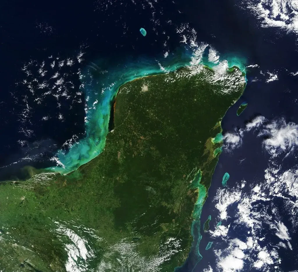
The Yucatán Peninsula is a vast slab of porous limestone, the same soluble rock that produces thousands of cenotes inland and blue holes offshore. Image: NASA Earth Observatory (Terra/MODIS), by Lauren Dauphin. Public domain. Source: NASA Earth Observatory.
What is the deepest blue hole in the world, and where is it?
Taam Ja’ lies in Chetumal Bay, a wide, shallow estuary tucked into the southeast corner of the Yucatán Peninsula, in the Mexican state of Quintana Roo, right against the border with Belize. The precise spot is in the central part of the bay, roughly 4.5 kilometers from Tamalcab Island and about 19.2 kilometers from the city of Chetumal, inside a state-protected reserve called the Chetumal Bay–Manatee Sanctuary. From a boat, you would never guess what is below. The bay here is only about five meters deep, the water is cloudy with sediment, and the surface gives nothing away except, as local fishermen noticed long ago, an oddly calm patch where the chop seems to flatten out.
Drop below that flat patch and the seafloor falls away into a near-vertical shaft. The mouth is almost a perfect circle covering about 13,690 square meters, with walls plunging at slopes steeper than 80 degrees. The whole structure narrows downward like an enormous cone lined with biofilm, soft limestone, and ledges of gypsum. And it keeps going down, past the reach of scuba divers, past the limit of the research team’s cable, into water that has never seen sunlight and that may, the scientists suspect, connect through hidden passages to the open Caribbean.
The depth figure deserves care, because it is one of the most commonly garbled facts about this place. Taam Ja’ is not “423.6 meters deep” in the way the Empire State Building is 443 meters tall. The 423.6-meter reading is a confirmed minimum. The bottom has never been reached, so the real depth is unknown and certainly greater. The honest way to state it is the way the researchers themselves do: more than 420 meters below sea level, with its floor still beyond instruments.
How deep is the Taam Ja’ Blue Hole, exactly?
The headline numbers come from two casts of an oceanographic profiler on December 6 and December 13, 2023. As the team wrote in their April 2024 paper, “The depths attained from CTD casts on both December 6th and 13th, 2023, recorded 416.0 and 423.6 mbsl, respectively. Consequently, these new findings unequivocally establish the Taam Ja’ Blue Hole (TJBH) as the world’s deepest known blue hole, with its bottom still not reached.”
That 423.6-meter mark put Taam Ja’ comfortably past the previous champion, the Sansha Yongle Blue Hole, better known as the Dragon Hole, in the South China Sea. The Dragon Hole’s depth was announced by China’s Xinhua News Agency in July 2016 at 300.89 meters, and a more detailed 2017 survey with a remotely operated vehicle, published in Scientific Reports, refined it: “The observed deepest portion of the SYBH is at 301.19 m below the local 10-year mean sea level.” Call it roughly 301 meters either way. Taam Ja’ beats it by more than 120 meters, and, crucially, the Mexican hole was still descending when measurement stopped. The gap between first and second place is almost certainly larger than the records show.
Dr. Juan Carlos Alcérreca Huerta, the coastal-engineering researcher at ECOSUR (El Colegio de la Frontera Sur) who led both studies, put it bluntly to ZME Science: “The maximum depth is a complete mystery.” The team stopped lowering the cable not because they hit rock but because going further risked destroying the instrument under mounting pressure.
Why “subtract 80 meters” is the wrong way to read the depth
Here is where a lot of popular coverage trips. The cable used to lower the profiler was about 500 meters long. The instrument recorded only 423.6 meters of depth. A tempting shortcut is to assume roughly 80 meters of “extra” cable means the real hole is shallower than the cable length suggests, or to treat the discrepancy as measurement error. The truth is more interesting and more physical.
Depth on a CTD is not derived from how much cable you pay out. It is calculated from water pressure, which rises predictably, about one atmosphere for every ten meters or so of seawater. The instrument knows how deep it is regardless of cable angle. The reason the cable was longer than the measured depth is that the profiler did not fall straight down. As the paper notes, “The CTD measurements revealed a depth shorter than the cable length (~500 m) employed to lower the CTD profiler, indicating an oblique descent of the instrument at an angle of approximately 32.1–33.7° from the vertical.”
In plain terms: the probe slid down at a slant of roughly 32 to 34 degrees off vertical, so it traveled more cable-distance than vertical-distance, the long side of a right triangle. The team could not say for certain whether that lean was caused by the shape of the shaft itself (a tilted or curving cave, not a clean vertical pipe) or by currents pushing the line sideways. Either way, the deployed cable length and the true vertical depth are two different quantities, and conflating them is the single most common error you will read about Taam Ja’. The pressure reading is the depth; the cable just had to go around a corner to get there.

A CTD (conductivity, temperature, depth) profiler being deployed from a research vessel. At Taam Ja’, a Valeport SWiFT CTD measured depth from water pressure as it descended, and revealed it had sunk at a slant of 32–34° off vertical. Image: CSIRO ScienceImage #10807, CC BY 3.0. Source: Wikimedia Commons.
How do blue holes form? A short course in karst
To understand Taam Ja’, you have to understand the rock it sits in. The Yucatán Peninsula is built from limestone, a soft, soluble carbonate rock laid down over millions of years from the skeletons of marine organisms. Limestone has a chemical weakness: it dissolves in slightly acidic water. Rain picks up carbon dioxide from the air and soil, becomes mildly carbonic, and eats away at the stone wherever it seeps through cracks. Geologists call the resulting landscape of caves, sinkholes, and underground rivers karst, and the process of carving caves out of it speleogenesis.
Blue holes are karst features that finished forming on dry land and then drowned. During the Pleistocene ice ages, enormous volumes of water were locked up in continental ice sheets, and global sea level dropped by roughly 100 to 120 meters. Stretches of seafloor that are submerged today stood exposed as dry, weathering limestone. Rainwater drained downward through that rock, hollowing out caverns and vertical shafts. Where a cave roof grew too thin to support itself, it collapsed, leaving a steep-walled pit. Then the ice melted, sea level climbed back up, and the sea flooded the holes from the bottom up. Woods Hole Oceanographic Institution describes the result well: in a few rare spots “the ocean floor suddenly falls away hundreds of feet into a round, gaping, steep-walled maw big enough to swallow a small ship.”
Two zones matter in this story. The vadose zone is the unsaturated rock above the water table, where air-filled caves form and stalactites can grow as mineral-rich water drips. The phreatic zone is the saturated rock below the water table, where water fills every pore and dissolution works differently. As ice-age sea levels rose and fell, the water table moved up and down through the limestone, and the boundary between these zones, where dissolution is most aggressive, migrated with it. That migration helps explain the ledges and terraces found inside many blue holes, including Taam Ja’, which preserves discontinuous shelves near its rim.
The deep blue color that gives these features their name is simply optics. Shallow water over pale carbonate sand scatters light and looks turquoise. Over a deep shaft, light sinks and never comes back, so the surface reads as a dark sapphire disk against the bright lagoon. Curiously, Taam Ja’ is less vividly blue than famous examples like Belize’s Great Blue Hole, because Chetumal Bay’s sediment-laden water is greenish and murky, which is exactly why this colossal hole stayed hidden for so long.
Who discovered the Taam Ja’ Blue Hole?
The scientific discovery rests on local knowledge, as these things often do. The most widely repeated origin story holds that a local diver, Jesús Artemio Poot-Villa, found the hole around 2003, by one account literally following a grouper that darted into its mouth. That backstory is reported in popular accounts rather than settled in the peer-reviewed literature, so it is best treated as community memory, not documented fact. What is documented is that Poot-Villa, a regional fisherman and fly-fishing guide with intimate knowledge of Chetumal Bay, brought the feature to the attention of ECOSUR scientists.
The institutional thread runs through a long-term oceanographic monitoring program. As Oceanographic magazine recounts, there was “the seven-year monitoring project focused on studying the dynamics of the Gulf of Mexico and the Caribbean Sea coordinated by Dr. Laura Carrillo,” beginning around 2016. As that work wrapped up, Poot-Villa mentioned an “interesting structure” in the bay and invited the researchers to look. ECOSUR has been emphatic about crediting him: “the significant collaboration of community guide Jesús Artemio Poot Villa was fundamental for the start of the investigations at Taam ja’.” The first instruments down the hole were almost comically low-tech, a rock on a rope, which reached 30 meters, then 50, then 130 without touching bottom. That was the hint that something extraordinary lay below.
The 2021–2023 survey: a record that turned out to be too small
The first formal expedition took place in September 2021, using scuba, echosounders, CTD profilers, and water sampling. The results appeared on February 23, 2023 in Frontiers in Marine Science, in a paper titled “First insights into an exceptionally deep blue hole in the Western Caribbean: The Taam ja’ Blue Hole” (DOI 10.3389/fmars.2023.1141160).
That study pegged the maximum depth at 274.4 meters below sea level, which already made Taam Ja’ the second-deepest blue hole on Earth and the only one known inside an estuary. The 2023 paper also laid out the hole’s anatomy in detail: a nearly circular mouth at about 4.5–5.0 meters depth, an area of roughly 13,690 square meters, walls steeper than 80 degrees, and a conic profile coated in biofilms with limestone and gypsum ledges. The mouth’s long axis runs 151.8 meters and is oriented about 10.76 degrees clockwise from north, strikingly close to the orientation of major faults in the area, hinting that the hole’s growth was guided by fractures in the bedrock.
The water inside was already known to be strangely layered, even at 274 meters: a hypoxic (low-oxygen) zone from about 5 to 20 meters, a chemocline (a sharp chemical transition) between roughly 50 and 80 meters, and an anoxic (oxygen-free) layer below about 110 meters. Chemical analysis showed the water was mostly diluted seawater. But the 2021 instruments couldn’t confirm the true bottom, echo-sounding gets confused in a layered, possibly non-vertical cave, and that unfinished business set up the return trip.
The December 2023 expedition: how scientists measured a hole they couldn’t see
In December 2023 the team came back with a different tool: a CTD profiler, specifically a SWiFT model made by Valeport, a UK oceanographic-instrument manufacturer. CTD stands for conductivity, temperature, and depth. The device measures the electrical conductivity of the water (which gives salinity), its temperature directly, and depth from pressure, transmitting readings up the cable in real time. It is, as several outlets noted, one of the most standard instruments in oceanography, but using it inside a near-bottomless karst shaft is anything but standard.
Divers first explored the upper section down to about 30 meters, mapping the rim. They found the opening easier to see a few meters down, once below the murk; walls that started soft and biofilm-coated near the top and grew steeper and firmer with depth; and an occasionally overhanging, tilted roof largely free of biofilm where light no longer reached. Then came the casts on December 6 and December 13. Both blew past 400 meters. Neither found the floor.
Why did a CTD succeed where echo-sounding had failed? Sonar works by timing an echo, but in a blue hole the speed of sound bends and scatters as it crosses layers of sharply different density, temperature, and salinity. Worse, a sound pulse can bounce off a slanting wall or ledge and return early, fooling the system into “seeing” a false bottom, which is very likely how the 2021 echosounder produced its too-shallow 274-meter figure. A physical instrument on a cable, reading pressure directly, sidesteps that problem entirely. It just has to survive the descent.
Why hasn’t anyone reached the bottom of Taam Ja’?
Several obstacles stack up. Pressure is the first: at more than 420 meters, the water column presses with over 40 atmospheres, and the team declined to push the CTD deeper for fear of damaging it. Human divers are out of the question, recreational and even technical scuba bottoms out hundreds of meters shallower, and the deep water is anoxic and likely laced with toxic hydrogen sulfide. The oblique, ~32-degree descent also suggests the shaft is not a clean vertical tube; it may tilt, narrow, widen into chambers, or branch into side passages, meaning the deepest point might not even sit directly beneath the opening. And the murky, layered environment defeats the remote-sensing shortcuts that work elsewhere.
The researchers were explicit that this is a technology gap, not a closed question. They called for future work to “incorporate advanced underwater navigation technologies in conjunction with CTD profilers” to build an accurate three-dimensional picture. Asked how his team might measure past 423 meters, Alcérreca-Huerta told ZME Science: “Further exploration of the TJBH’s depths could be facilitated through the deployment of Remotely Operated Vehicles (ROVs) and CTD profilers capable of withstanding the water pressure.”
The layered water column, and the Caribbean tunnel hypothesis
The December 2023 casts did more than set a depth record. They mapped the water’s vertical structure, and the structure tells a story. The profiler picked up several pycnoclines, thin bands where water density jumps abruptly. Strong density boundaries resist mixing, so the layers above and below can stay separate for long stretches of time, almost like distinct fluids stacked in a glass. Near the surface, conditions matched what you’d expect in an estuary: warmer, fresher water, fed by land runoff into a partly enclosed bay. As the instrument descended, temperature and salinity shifted in steps, with sharp jumps marking each boundary.
Then something changed below roughly 400 meters. The trend reversed: temperature ticked upward and salinity climbed further, until the deep water resembled the open Caribbean. ECOSUR’s own summary makes the point: the water in the depths of the blue hole “resembled those that have been reported in the Caribbean Sea at depths of 0–150 m, which suggests the probable existence of subterranean connections between Chetumal Bay and the Caribbean Sea through this blue hole.”
This is the tantalizing part, and the part most prone to overstatement. The matching water mass is a strong hint that Taam Ja’ is plumbed into a deeper network of caves and conduits linking it to the sea, possibly part of an interconnected karst system threading through the Yucatán’s fractured bedrock. Some coverage has run further, floating links to aquifers as distant as Florida. But the researchers frame it as a hypothesis requiring confirmation, writing that the focus going forward is “deciphering its maximum depth and the possibilities of forming part of an underwater intricate and potentially interconnected system of caves and tunnels.” A subterranean Caribbean connection is plausible and exciting. It is not yet proven.
What lives in a blue hole? Anoxic water, sulfur bacteria, and astrobiology
Below their sunlit rims, blue holes turn hostile fast, and that hostility is precisely what makes them scientifically precious. Oxygen vanishes with depth, and in many holes a layer of dissolved hydrogen sulfide forms a chemical lid. The classic example is Belize’s Great Blue Hole, where a 2018 submarine expedition funded by Richard Branson, with Fabien Cousteau and submersible pilot Erika Bergman, documented a layer of hydrogen sulfide at roughly 300 feet (91 m), below which the water turns dark, anoxic, and lifeless. Below it, Bergman described total darkness and “absolutely no life”, a graveyard of conch shells and crabs that had sunk through and suffocated, and, somberly, the preserved remains of two divers lost years earlier.
Yet “no life” is true only for animals. In the anoxic, sulfur-rich depths of blue holes, specialized microbes thrive by metabolizing sulfur compounds like hydrogen sulfide instead of breathing oxygen, chemistry that is toxic to almost everything else. Taam Ja’s own anoxic layer, identified below about 110 meters in the 2021 survey, is a candidate home for exactly this kind of community. Researchers studying blue holes worldwide note that microbial diversity in these features can run several times higher than in ordinary ocean settings, and that the organisms living in permanent darkness on sulfur metabolism are compelling analogs for how life might persist in extreme places, including the buried, sunless oceans hypothesized beneath the icy crusts of Jupiter’s moon Europa and Saturn’s moon Enceladus. A blue hole, in other words, is a low-cost rehearsal stage for the search for life beyond Earth.
Blue holes are archives, too. The still, oxygen-starved water at the bottom preserves sediment in fine annual layers and protects fossils from decay. Bahamian blue holes have yielded records of ancient hurricanes, droughts, sea-level change, and even the bones of extinct tortoises and crocodiles. Western Caribbean blue holes like Taam Ja’ remain comparatively understudied, which is part of why the find matters: it opens a new natural laboratory in a region where these features were barely on the scientific map.
How does Taam Ja’ compare to the world’s other famous blue holes?
Putting the record in context shows just how far Taam Ja’ has pulled ahead of the field.
- Taam Ja’ Blue Hole (Mexico): more than 420 m and counting; confirmed casts of 416.0 m and 423.6 m; bottom not reached. The deepest known blue hole on Earth.
- Dragon Hole / Sansha Yongle (South China Sea): about 301 m (300.89 m by the 2016 survey; 301.19 m by the 2017 ROV study). The former record holder, near the Paracel Islands; local legend ties it to the Monkey King’s cudgel in Journey to the West.
- Dean’s Blue Hole (Bahamas): 202 m. Long Island’s freediving mecca, home to the Vertical Blue competition.
- Dahab Blue Hole (Egypt): about 130 m, in the Red Sea, with a notorious archway (“The Arch”) at around 56 m that has earned it a grim diving reputation.
- Great Blue Hole (Belize): about 318 m across and 124 m deep, near the center of Lighthouse Reef Atoll. The most photographed blue hole on the planet, and the one Jacques Cousteau put on the map in 1971. Taam Ja’ is more than three Great Blue Holes stacked on top of one another.
A common point of confusion is worth clearing up: Mexico’s Zacatón is a water-filled sinkhole about 335 meters deep, deeper than the Dragon Hole, but it is an inland, freshwater pit, not a marine blue hole, so it doesn’t compete for this title. The deepest known cave of any kind is Veryovkina (and historically Krubera-Voronya) in Georgia’s Caucasus, plunging past 2,000 meters. Taam Ja’s record is specifically for blue holes: marine or brackish, open to the surface, with their depth developed below sea level.
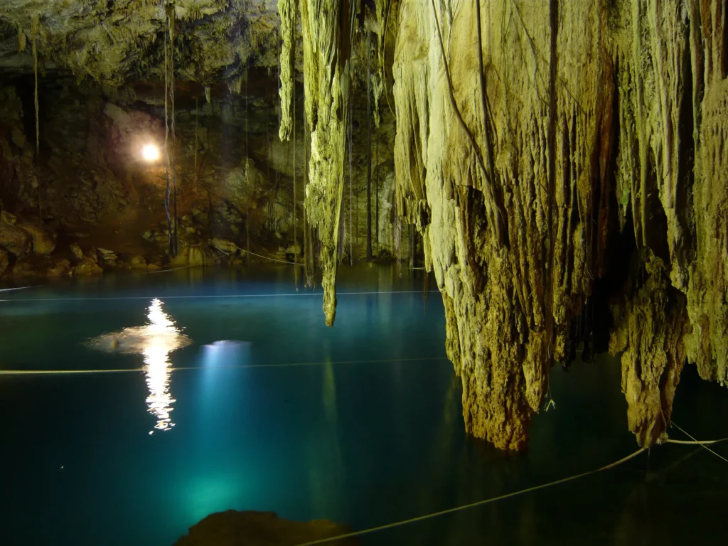
Cenotes vs. blue holes: the Yucatán’s drowned underworld
Taam Ja’ belongs to one of the most spectacular karst provinces on the planet. The Yucatán is honeycombed with cenotes, sinkholes that open to freshwater. The word comes from the Yucatec Maya ts’onot, meaning roughly “well” or “hole with water.” Estimates put the number at “at least 6,000 cenotes in the Yucatán Peninsula,” with some counts for the state of Yucatán alone running higher. Beneath them snake the longest flooded cave systems ever mapped. Sistema Sac Actun runs to hundreds of kilometers of surveyed passage, while Sistema Ox Bel Ha has long traded the world record with it and currently holds the lead: as of early 2026, CINDAQ put its surveyed length at roughly 541.7 km. Together, these two Mexican systems are the longest underwater caves on Earth.
So what separates a cenote from a blue hole? Chemistry and setting. Cenotes are inland sinkholes filled mainly with fresh groundwater, often perched above or within the freshwater aquifer. Blue holes are marine: they sit offshore or in estuaries, their water is salt or brackish, and their depth develops below sea level. Taam Ja’ has the morphology of a cenote, a near-circular, steep-walled karst pit, but the seawater chemistry and fully submerged setting of a blue hole. It is, in a sense, the bridge between the two. ECOSUR notes that before this discovery, blue holes weren’t even on the regional radar: the assumption was that the Yucatán had cenotes, full stop.
For the ancient Maya, these openings were not just water sources in a riverless landscape, they were sacred portals to Xibalba, the underworld, where priests communicated with the gods and the boundary between the living and the dead blurred. Divers in Sac Actun and related systems have recovered pre-Hispanic artifacts, ceremonial offerings, and some of the oldest human remains found in the Americas. The Yucatán’s karst also carries a deep-time scar: the northern peninsula hosts the Ring of Cenotes, a regional-scale arc of sinkholes that traces the buried rim of the Chicxulub impact crater: the mark left by the asteroid that struck about 66 million years ago and ended the age of dinosaurs. The same brittle, fractured limestone that recorded that catastrophe is the rock in which Taam Ja’ dissolved its way downward.
What happens next at Taam Ja’?
The April 2024 paper is, deliberately, a beginning rather than a conclusion. The obvious next step is a remotely operated vehicle rated for the pressure, paired with multibeam sonar, to build a true three-dimensional map of the shaft, find the actual floor, and test whether side passages branch off toward the Caribbean. The researchers have flagged exactly this approach, citing the decade-plus campaigns it took to map the Dragon Hole as a realistic template. Mapping the water exchange between the hole and the surrounding estuary matters for more than curiosity: contaminants and nutrients moving through the karst could travel in and out of the hole and on to the coral reefs and seagrass beds that local communities depend on.
That last point carries a warning. A world-record natural wonder a short boat ride from two countries’ coasts will draw visitors and pressure. Taam Ja’ lies within the Chetumal Bay–Manatee Sanctuary, and the team has noted that regulatory measures may be needed to protect both the fragile microbial communities in its depths and the broader reserve. There is a quieter human dimension, too: the discovery has become a point of local pride around Chetumal, complete with a song composed in the blue hole’s honor.
For now, Taam Ja’ keeps its central secret. We know it is the deepest blue hole in the world. We do not know how deep. Somewhere past 420 meters, in water that may have come from the open sea through passages no one has mapped, the shaft continues into the dark. Its record rests on a peculiar fact: no instrument has ever touched the floor.
Related reading on Geoscopy: the Kola Superdeep Borehole, humanity’s deepest hole into the land (confirm slug); Lituya Bay and the tallest wave ever recorded (confirm slug); Blood Falls and the microbes that live without sunlight (confirm slug).
Frequently asked questions about the Taam Ja’ Blue Hole
What is the deepest blue hole in the world?
The Taam Ja’ Blue Hole in Mexico’s Chetumal Bay, off the southeast Yucatán Peninsula, is the deepest known blue hole in the world. A CTD profiler measured it to at least 423.6 meters (about 1,390 feet) below sea level in December 2023 without reaching the bottom, so its true depth is greater than that and still unknown.
How deep is the Taam Ja’ Blue Hole?
Two CTD casts recorded 416.0 m and 423.6 m below sea level, both without touching the floor. The figure is a confirmed minimum, not a final depth, the bottom has never been reached. An earlier 2021 echo-sounder survey had estimated only 274.4 m, but that method was fooled by the hole’s layered water and non-vertical shape.
What does “Taam Ja'” mean?
“Taam Ja'” means “deep water” in Yucatec Maya, the language of the region where the blue hole was found. The name honors the Maya culture of the Yucatán Peninsula.
Is the Taam Ja’ Blue Hole connected to the Caribbean Sea?
Possibly, but it isn’t proven. Below about 400 meters, the water’s temperature and salinity start to resemble open-Caribbean conditions, which suggests Taam Ja’ may link to the sea through a hidden network of caves and tunnels. Researchers treat this as a hypothesis that needs confirmation from remotely operated vehicles and further mapping.


