Introduction
Two billion years ago, a rock between 20 and 25 kilometers across slammed into what is now the Free State province of South Africa, gouging a hole roughly 250 kilometers wide and turning a 25-kilometer section of the planet’s crust on its end. That figure, 20 to 25 kilometers, comes from a 2022 reanalysis published in the Journal of Geophysical Research: Planets, and it makes the Vredefort impactor larger than the asteroid that killed the dinosaurs.
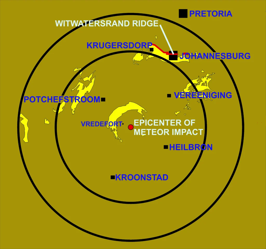
The crater itself is gone. What remains is the Vredefort Dome, an eroded dome about 90 kilometers across, ringed by hills that marks the rebound peak at the dead center of the largest confirmed impact structure on Earth. In 2022, a set of computer simulations rewrote the size of the object that made it.
How big was the asteroid that created the Vredefort crater?
For decades the textbook answer was an object about 15 kilometers in diameter traveling at 15 kilometers per second. That combination produces a crater roughly 172 kilometers wide. The problem is that the geological evidence at Vredefort points to a crater far larger than that. As the Allen team wrote in 2022, “commonly used estimates hover around 170–300 km diameter, with most leaning toward the larger end of that range (250–280 km).”
In 2022, a team led by Natalie Allen, who began the work as an undergraduate class project at the University of Rochester and published it as a PhD student at Johns Hopkins University, set out to reconcile the impactor with the crater. Working with Miki Nakajima, an assistant professor of Earth and environmental sciences at Rochester, along with Kai Wünnemann of the Museum für Naturkunde in Berlin, Søren Helhoski, and Dustin Trail, Allen ran impact simulations using the shock-physics code iSALE. Their paper, “A Revision of the Formation Conditions of the Vredefort Crater,” appeared in the Journal of Geophysical Research: Planets on August 8, 2022.
The simulations showed that to excavate a crater about 250 kilometers across, the impactor had to be much larger than 15 kilometers. Two combinations fit the evidence. As the authors put it, “we found an impactor of 20 km with an impact velocity of 25 km/s creates a crater the size of Vredefort”; alternatively, an object 25 kilometers across striking at 15 kilometers per second works equally well. The team summarized the impactor as 20 to 25 kilometers across, moving between 15 and 25 kilometers per second.
The model did more than match the crater diameter. It reproduced the distribution of shock features still visible in the rock today: breccias, shatter cones, and planar deformation features in quartz. That match confirmed a larger, faster impactor is consistent with the physical record.
Why this means it beat the dinosaur-killer
The asteroid that formed the Chicxulub crater in Mexico 66 million years ago, the one tied to the extinction of the non-avian dinosaurs, is generally modeled at around 10 kilometers in diameter, and Chicxulub spans roughly 180 kilometers. A Vredefort impactor of 20 to 25 kilometers is larger, and the crater it left was wider.
The bigger impactor left no mass-extinction layer, because there was almost nothing complex to kill. “Unlike the Chicxulub impact, the Vredefort impact did not leave a record of mass extinction or forest fires given that there were only single-cell lifeforms and no trees existed two billion years ago,” Nakajima said. “However, the impact would have affected the global climate potentially more extensively than the Chicxulub impact did.” She added that dust and aerosols would have blocked sunlight and cooled the surface, and that “after the dust and aerosols settled, which could have taken anywhere from hours to a decade, greenhouse gases such as carbon dioxide that were emitted from the impact would have raised the global temperature potentially by several degrees for a long period of time.”
The simulations also tracked where debris landed. Earlier work had matched impact ejecta to the Karelia region of present-day Russia. Allen’s model implies that two billion years ago the landmass carrying Karelia sat only about 2,000 to 2,500 kilometers from the crater, far closer than the two regions are today, and a possible check on reconstructions of where ancient continents sat.
How old is the Vredefort crater?
The impact happened about 2.02 billion years ago, in the Orosirian Period of the Paleoproterozoic Era. The most precise date comes from a 1996 study by Sandra Kamo, Wolf Uwe Reimold, Thomas Krogh, and W. P. Colliston, published in Earth and Planetary Science Letters. They measured a concordant uranium-lead age of 2,023 ± 4 million years from newly crystallized, unshocked zircon grains inside recrystallized pseudotachylitic breccia near the center of the structure, material that formed at the moment of impact.
That age has held up across methods. Argon-argon dating of coesite- and stishovite-bearing pseudotachylytes by John Spray, Simon Kelley, and Reimold in 1995 placed the event near the same point, and the granophyre dikes and Witwatersrand goldfield breccias all return ages around 2,020 million years. Some studies cite slightly different figures of 2.019 to 2.020 billion years, but the spread is small.
The Vredefort rocks themselves are far older than the impact. The granite-greenstone basement at the core belongs to the Kaapvaal Craton and dates to between roughly 3.1 and 3.5 billion years. The impact at 2.02 billion years simply rearranged crust that had already existed for more than a billion years.
Is Vredefort the largest impact crater on Earth?
By the consensus of impact researchers, yes, Vredefort is the largest confirmed impact structure on Earth. UNESCO describes it as the oldest, largest, and most deeply eroded complex meteorite impact structure in the world, and the site of the greatest single energy-release event known to have affected the planet. The original crater outranked the 200-kilometer Sudbury Basin in Canada and the roughly 180-kilometer Chicxulub crater.
The exact diameter is uncertain, and reputable sources disagree. NASA’s Earth Observatory states the crater measured “somewhere between 180 and 300 kilometers wide.” Wikipedia’s range runs from 170 to 300 kilometers. The Allen team adopted an original diameter of 250 to 280 kilometers. Scaling work by Ann Therriault, Richard Grieve, and Reimold in 1997, based on the spread of shock features, pointed toward roughly 300 kilometers. UNESCO’s documentation cites an overall diameter of “some 3-400 km” and a radius of 190 kilometers for the full disturbed zone.
Roger Gibson of the University of the Witwatersrand, a leading expert on the structure, explained why pinning down the number is so hard. “If you consider that the original impact crater was a shallow bowl like you would serve food in, and you were able to slice horizontally through the bowl progressively, you would see that the bowl’s diameter will decrease with each slice you take off,” he said. “For this reason, we are unable to categorically fix where the edge now lies.” More than two billion years of erosion has sliced away the upper part of the bowl, so the surviving width is smaller than the crater ever was.
The ‘largest’ title applies to confirmed structures. The Wilkes Land feature buried under the East Antarctic ice sheet, if it ever turns out to be an impact crater, would be far larger, but its impact origin is unconfirmed.
Is Vredefort the oldest crater on Earth?
No, it lost that title in 2020. The Yarrabubba impact structure in Western Australia was dated to 2,229 ± 5 million years by a team led by Timmons Erickson, then at NASA’s Johnson Space Center, working with researchers from Curtin University. They measured uranium-lead ages on shock-recrystallized monazite and zircon. That makes Yarrabubba about 200 million years older than Vredefort, and the current record-holder for the oldest confirmed impact structure on Earth.
Vredefort therefore sits as the second-oldest precisely dated impact structure, ahead of the 1,850-million-year-old Sudbury Basin. Older candidates exist (the Suavjärvi structure in Russia, the Maniitsoq structure in Greenland, the Dhala structure in India), but each has either a poorly constrained age or contested evidence that it is an impact at all. Among the trio of large, precisely dated Precambrian impacts, Vredefort is the biggest.
Where is the Vredefort Dome located?
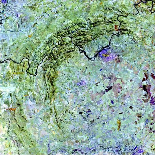
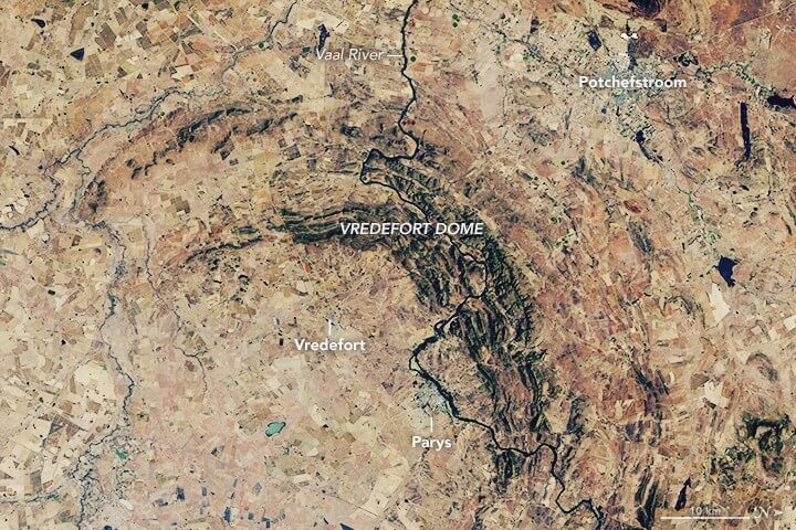
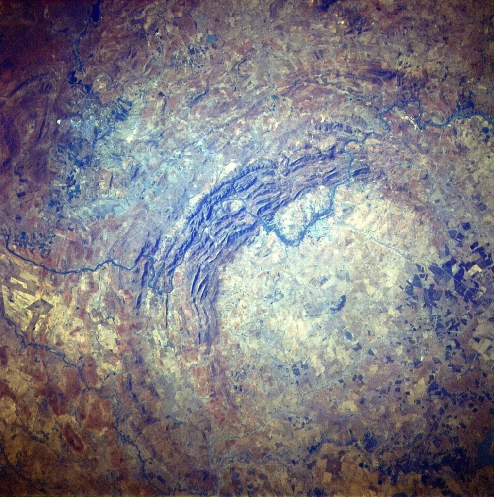
The Vredefort Dome sits about 120 kilometers southwest of Johannesburg, straddling the boundary between South Africa’s Free State and North West provinces. The small farming town of Vredefort lies near the geometric center; the larger town of Parys, on the Vaal River, is the local tourist hub. Koppies and Venterskroon round out the cluster of settlements inside the structure. The Vaal River winds through the ring of hills, and the steepest part of its course runs through the dome, producing rapids and an unusual braided pattern.
From the ground the impact is nearly invisible because of its size and erosion. The pattern only resolves from the air or from orbit, where the northwestern half of the dome appears as a semicircular set of concentric ridges. The southeastern half is buried beneath younger rocks of the Karoo Supergroup, which is why the visible ring is a crescent rather than a full circle.
UNESCO inscribed the Vredefort Dome as a World Heritage Site in 2005, the seventh such site in South Africa. The serial property covers about 30,111 hectares, a main area of 30,108 hectares plus three one-hectare satellite components, and is wrapped in a five-kilometer buffer zone meant to shield it from development. The committee listed it under natural-heritage criterion (viii), calling it the only place on Earth that exposes a full geological profile of an astrobleme below the crater floor.
What is the difference between the Vredefort Dome and the Vredefort crater?
The two names describe different things. The Vredefort crater, or more precisely the impact structure, is the entire 250-to-300-kilometer feature blasted out by the asteroid, most of which has eroded away or lies buried. The Vredefort Dome is the much smaller central uplift at the heart of that crater: the rebound peak of rock that surged upward in the minutes after impact, the way water rebounds into a column after a stone drops into it.
When a large object strikes, the ground first punches down into a deep transient cavity, then the floor rebounds. At Vredefort the rebound lifted deep crust upward by an estimated 25 kilometers and rotated the surrounding strata until they stood nearly vertical. The dome is what survived after roughly 8 to 11 kilometers of overlying rock weathered off; impact modelers typically adopt about 10 kilometers. Measured today, the dome’s ring of hills spans about 70 kilometers, the broader uplifted structure about 90 kilometers, and the granite core at the very middle about 40 kilometers.
That deep erosion is the source of Vredefort’s scientific value. Most craters are studied from the top down, through their preserved floors and rims. Vredefort can only be studied from the bottom up: erosion removed the bowl entirely and exposed the deep rock that once lay beneath it. Visitors driving the 50 kilometers from Potchefstroom toward Vredefort cross rock that grows older with each kilometer, ending on 3.1-to-3.5-billion-year-old granites that once sat about 25 kilometers underground. “Such exposed crustal sections are incredibly rare on Earth,” Gibson said. “The added bonus here is that the rocks preserve an almost continuous record spanning almost one-third of Earth’s history.”
How geologists proved it was an impact, not a volcano
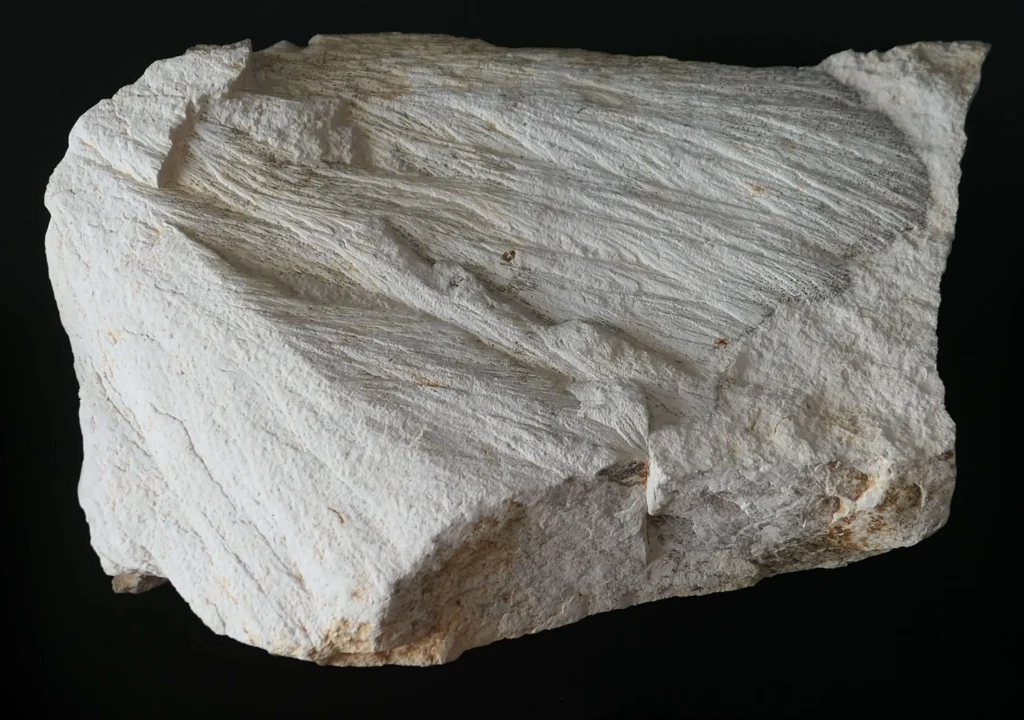
For most of the twentieth century, the Vredefort Dome was read as a volcanic or “cryptoexplosion” feature welling up from below. The shift began in the 1930s, when American geologists John Boon and Claude Albritton noted the absence of volcanic material and the resemblance to known impact sites. In 1961, R. B. Hargraves documented shatter cones in the Vredefort rocks, the conical, striated fracture patterns that form only under the extreme shock of an impact or a nuclear blast. The case hardened through the mid-1990s, when microdeformation studies confirmed the planar features in Vredefort quartz as genuine shock damage and zircon dating tied the deformation to a single event 2.02 billion years ago. Geochemists also detected a small meteoritic component in the melt rock.
Shatter cones at Vredefort appear in rocks up to about 90 kilometers from the center. Planar deformation features in quartz, microscopic lattice damage diagnostic of shock, extend to roughly 45 kilometers, and impact breccias reach about 150 kilometers out. Those radii are the rulers researchers use to back out a crater diameter of 250 to 300 kilometers. The structure also preserves coesite and stishovite, dense high-pressure forms of silica that, in rocks this close to the surface, can only have formed under impact shock, further evidence no slow geological process can mimic.
Granophyre dikes and pseudotachylite: the melt record
Vredefort preserves two kinds of impact-generated melt rock, and they tell different parts of the story. The Vredefort Granophyre is true impact melt, rock that was liquefied by the collision. It survives today as nine known dikes that fill vertical fractures in the dome. Within the granite core, these dikes run up to 20 meters wide and 4 kilometers long; along the core-collar boundary they reach up to 65 meters wide and 9 kilometers long, according to measurements by Ann Therriault and colleagues. The granophyre carries about 20 percent shocked rock fragments by volume and contains geochemical traces of the impactor itself, marking it as drained remnants of the melt sheet that once pooled in the crater.
The second kind, pseudotachylitic breccia, forms dark veins and networks that range from millimeter-thin seams to bodies tens of meters across. These appear throughout the dome and far out into the Witwatersrand goldfields. They formed by a mix of frictional melting as crustal blocks slid past one another and decompression melting as the central uplift collapsed.
The melt rocks also place an upper bound on how long the structure took to settle. Work on the granophyre dikes indicates that emplacement occurred in two or more pulses and that crustal relaxation following the impact lasted on the order of a million years, a slow tail to an event whose violent phase lasted only minutes.
The gold connection: why Johannesburg owes its wealth to an asteroid
The Witwatersrand Basin around Vredefort holds the richest gold deposit ever found. The basin has produced more than 40,000 tonnes of gold, estimates of its share of all the gold ever mined run from roughly a fifth to as much as half, depending on whose accounting you use. Gold was discovered in the basin in 1886, on the Langlaagte farm near present-day Johannesburg, and the rush that followed built the city. The same gold-bearing strata crop out in the dome’s collar, roughly 120 kilometers to the southwest.
The gold predates the impact: it was laid down in ancient river sediments starting around three billion years ago. But the impact may explain why it is still here to mine. The collision downfaulted and folded the gold-bearing strata, dragging some of it deeper and rotating the layers into the concentric arcs seen today. As Reimold and colleagues noted in their synthesis of the structure’s melt rocks, the Witwatersrand resource “is now believed by some workers to have been preserved from erosion primarily as a consequence of the downfaulting and folding of the gold-bearing strata due to the Vredefort impact.” The impact’s heat also drove fresh fluid flow through rock whose original pores had long since sealed, reshaping how the gold sits in the reefs.
The relationship runs the other way too. The structure has generated at least 750 scientific publications since 1937, by the count in its World Heritage documentation, many of them driven by mining and exploration drilling on the geology and natural resources of Vredefort, many of them driven by mining and exploration drilling that exposed the structure’s deep architecture. The same mining the impact made worthwhile ended up mapping the impact itself.
Reading the rings: how the impact rearranged the crust
The concentric pattern visible from space is the eroded root of the crater’s deformation. Around the granite core, the impact overturned and steeply tilted the layered rocks of the Witwatersrand Supergroup, the Ventersdorp lavas, and the Transvaal Supergroup. Moving outward, the sequence of rock ages reverses in places, the result of strata being folded back on themselves. The hardest layers, quartzites in particular, resist erosion and stand up as the white-lined ridges of the Vredefort Mountainland.
Vredefort is also one of the few multi-ring impact structures on Earth. Multi-ring basins are common elsewhere in the solar system, Valhalla on Jupiter’s moon Callisto is the classic example, but on Earth, erosion and plate tectonics have erased nearly all of them. The shock even reached features used by later science: shock waves fractured zones of weakness in much older dolomites, opening the voids that later became caves like Sterkfontein.
What the impact would have done to the planet
Two billion years ago, Earth’s biosphere was microbial. The atmosphere had only recently begun to carry free oxygen after the Great Oxidation Event, and there were no plants, animals, or forests to burn. An impactor of 20 to 25 kilometers would still have been globally consequential. The model points to dust and aerosols thrown high into the atmosphere, blocking sunlight and cooling the surface long enough to threaten the photosynthetic organisms that did exist, followed by a greenhouse rebound from impact-released carbon dioxide that could have warmed the planet by several degrees for an extended period.
Because there were no hard-shelled creatures or land plants to leave a fossil extinction layer, the climatic aftermath is reconstructed from physics rather than read from a body count. A more accurate model of the largest impact on Earth sharpens how researchers simulate other ancient impacts and assess future ones.
Frequently asked questions
How old is the Vredefort crater?
The impact occurred 2,023 ± 4 million years ago, a date measured by uranium-lead dating of impact-formed zircon grains in a 1996 study by Kamo, Reimold, Krogh, and Colliston. That places it in the Orosirian Period of the Paleoproterozoic Era. The rocks it deformed are much older still, dating back more than three billion years.
How big was the asteroid that hit Vredefort?
The 2022 Allen et al. study estimated the impactor at 20 to 25 kilometers across, traveling at 15 to 25 kilometers per second. That is larger than the roughly 10-kilometer asteroid linked to the Chicxulub crater and the dinosaur extinction. The older textbook figure of a 15-kilometer impactor produced a crater too small to match the geological evidence.
Can you visit the Vredefort Dome?
Yes. The dome is a UNESCO World Heritage Site about 120 kilometers southwest of Johannesburg, roughly a two-hour drive. The town of Parys on the Vaal River is the main base for visitors, and guided geological tours, hiking, and river rafting are available. The structure is so large that its shape is best appreciated from satellite images or elevated viewpoints rather than from a single spot on the ground.
Why is the Vredefort crater important for gold mining?
The impact deformed the gold-bearing Witwatersrand Basin, which has produced more than 40,000 tonnes of gold, about 22 percent of all the gold accounted for above the surface. By downfaulting and folding the gold reefs, the impact is thought to have helped preserve them from erosion, and the heat it generated drove fluids that reshaped the ore. Gold was discovered in these rocks in 1886.
Is Vredefort still the oldest impact crater on Earth?
No. Since 2020, the Yarrabubba structure in Western Australia, dated to 2,229 ± 5 million years, has held the record as the oldest confirmed impact structure, about 200 million years older than Vredefort. Vredefort remains the largest confirmed impact structure and the second-oldest precisely dated one.
What are shatter cones and pseudotachylite?
Shatter cones are conical, striated fractures that form in rock under the intense shock of an impact, and they are among the diagnostic surface signs of an impact structure. Pseudotachylite is a dark melt rock produced when rock is melted by friction and decompression during the impact. Both are abundant at Vredefort and helped confirm its impact origin.