Introduction
Sometime between 1504 and 1510, in the Italian Apennines, Leonardo da Vinci turned a fossil seashell over and rejected the explanation everyone accepted. These inland shells, the learned opinion held, had been swept there by the biblical Flood, or had grown inside the stone like crystals. Leonardo found both ideas absurd. Rain runs downhill, he reasoned, so a receding flood would carry shells away from mountains, not toward their summits. A shell anchored in rock could never have fed itself. They were the remains of once-living animals, buried on a seafloor that later rose. The same reasoning explains the seashells on Mount Everest, the highest rock on Earth, which was once a tropical seabed.
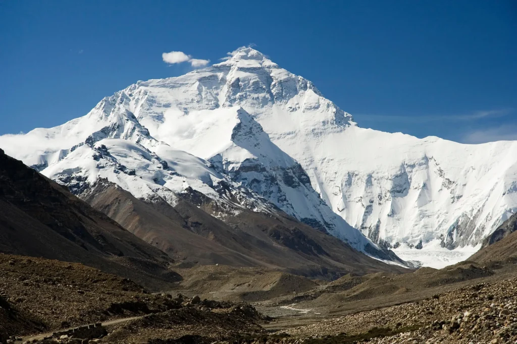
The official height of that pyramid is 8,848.86 metres, a figure Nepal and China announced jointly on 8 December 2020 after each sent survey teams to the summit and combined satellite positioning with ground-penetrating-radar data. Strip away the snow and ice and the rock itself stands at 8,844.43 metres. Either way, the topmost stone is limestone, a sedimentary rock that forms underwater from the carbonate remains of living things. The summit of the world is built from a dead sea.
This article explains, with the science stated as settled where it is settled and flagged where it is genuinely open, how marine fossils ended up on Everest. The short answer rests on two facts that sound unrelated and are tightly connected: the rock is roughly 450 million years old, and the continent it rode in on crashed into Asia. The seashells on Mount Everest are genuine marine fossils, and their presence is among the clearest physical evidence the planet offers for plate tectonics and deep time. Related reading on this site covers how limestone forms, what fossils tell us about ancient environments, and the basics of plate tectonics.
The reveal: a summit made of old seafloor
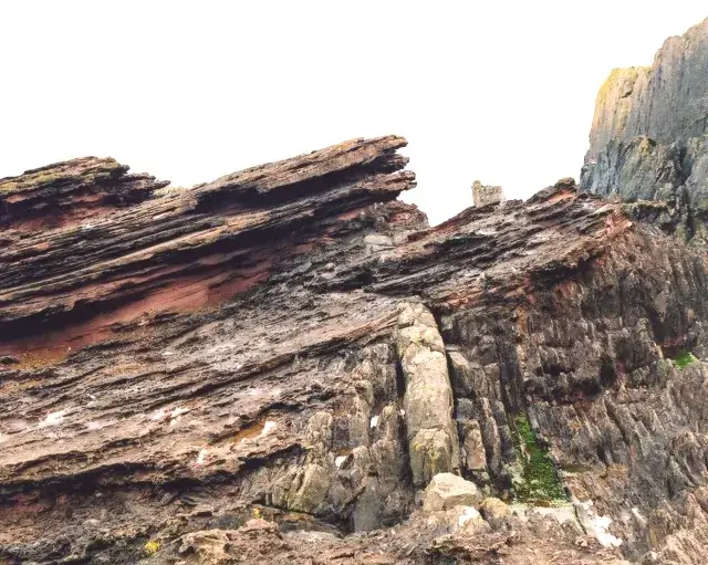
The rock unit that caps Everest has a name: the Qomolangma Formation, after Chomolungma, the Tibetan name for the mountain. It is a band of pale grey to light brown limestone that runs from the summit down to roughly 8,600 metres, where it meets the formation below. Climbers on the final pyramid walk across lithified seafloor the whole way to the top.
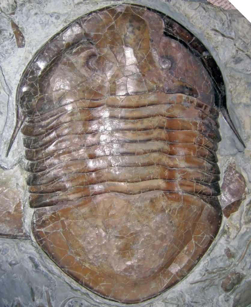
The decisive scientific description came in 2005, when Harutaka Sakai and colleagues at Kyushu University and partner institutions published a study in the journal Island Arc on limestone collected from the very top of the mountain. Under the microscope, the summit rock turned out to be a peloidal limestone, built largely of small rounded carbonate pellets and packed with the broken skeletal remains of marine invertebrates. The team identified fragments of trilobites, ostracods, and crinoids. These were pebble-sized pieces of debris interbedded within finely layered lime mud, and the authors read them as material that had broken off a shallow carbonate bank and been redeposited on the gentler slopes around its margin. The summit, in short, is storm-shuffled rubble from a warm, shallow tropical sea, cemented into stone and later carried to the height it now occupies.
The animals in the stone
The Everest assemblage reads like a census of the early Paleozoic seafloor. Crinoids, commonly called sea lilies, are echinoderms, relatives of starfish and sea urchins. They anchored to the bottom on long, segmented stalks and filtered food from the passing water, and their disc-shaped stem segments, called ossicles, are scattered through the rock. Some Ordovician seafloors held dense meadows of them. Trilobites were armoured arthropods, their bodies divided lengthwise into three lobes, that crawled and swam across the same floor; the group survived for nearly 270 million years before vanishing at the end of the Permian. Ostracods are tiny crustaceans housed in hinged, bean-shaped shells, still common in the oceans today.
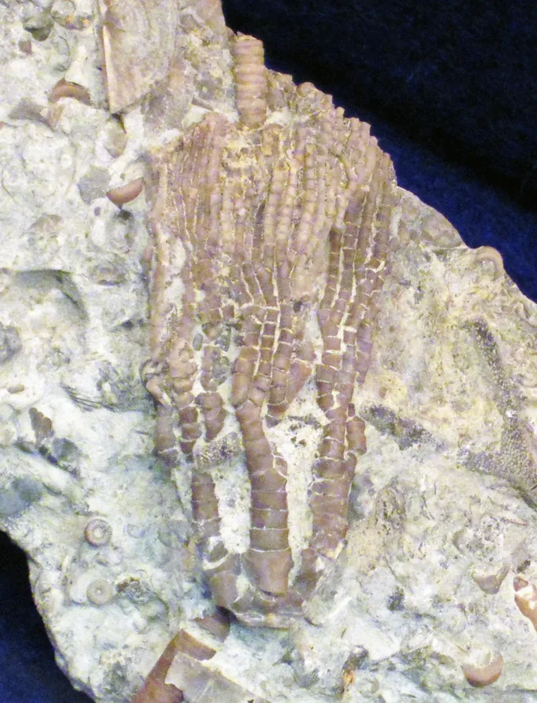
Work on equivalent rock layers exposed at lower altitude near Nyalam, in southern Tibet, has widened the list. The Chiatsun Group there, the same succession that correlates with the summit beds, has yielded brachiopods (lamp shells, superficially clam-like but unrelated to clams, attached to the seafloor by a fleshy stalk), conodonts (the tooth-like microfossils of an eel-shaped early vertebrate), nautiloids (shelled relatives of squid and octopus), gastropods, and more trilobites and crinoids. Renbin Zhan and colleagues, in a 2014 paper in Palaeontology, described a brachiopod fauna dominated by suspension-feeding orthides and strophomenides from these beds, and Stephen Donovan and colleagues, in Geological Journal in 2012, described a primitive stalked crinoid from the same group. The picture is of a busy, shallow, sunlit seafloor crowded with filter feeders.
The first definite fossils on the mountain were found a century ago. Noel Odell, the geologist on the 1924 British expedition who was the last man to see George Mallory and Andrew Irvine alive, recorded his discovery at about 7,770 metres in his own words: “At about 25,500 feet I came upon a limestone band which to my joy contained fossils – the first definite forms found on Everest!” Later study of his and others’ samples found that even the Yellow Band carries crinoid debris: petrographic work on marble collected high on the mountain, reported in Augusto Gansser’s 1964 Geology of the Himalayas, found it to contain roughly 5 percent recrystallized crinoid ossicle fragments. Edmund Hillary collected limestone near the summit on the 1953 first ascent. These fossils were among the first scientific facts ever brought down off the mountain.
These animals lived during a burst of evolutionary activity that paleontologists call the Great Ordovician Biodiversification Event, or GOBE. As Thomas Servais and David Harper set out in a 2018 review in Lethaia, this was the most sustained increase in marine biodiversity in the planet’s history, running roughly from 485 to 460 million years ago, an interval in which the number of marine animal genera expanded several-fold. The groups that would go on to dominate Paleozoic seas, including articulate brachiopods, crinoids, bryozoans, and cephalopods, rose to prominence and displaced the older fauna of the Cambrian. The creatures in Everest’s summit limestone were participants in that radiation. More than that, the rock dates from one of the most consequential chapters in the history of animal life.
How the age is known
An Ordovician age for the summit was first established in the 1970s, and it has been sharpened considerably since. The most precise dating comes from conodonts, whose rapidly evolving forms make them excellent timekeepers for the early Paleozoic. In 2021, Svend Stouge, David Harper, and colleagues reported in Geological Magazine on conodonts from the Chiatsun Group near Nyalam. They tied part of the section to the Pygodus serra conodont zone, which falls in the upper Darriwilian stage of the Middle Ordovician. That places the rock at roughly 460 to 470 million years old, with associated material in the broader sequence reaching down toward the Cambrian–Ordovician transition below. The IUGS summarizes the summit’s age as about 450 million years, a round figure that sits comfortably within this window.
The same conodont study carried a bonus. Conodont fossils change colour permanently when heated, and the degree of darkening, captured in a measure called the colour-alteration index, records the maximum temperature the rock later reached. The Nyalam conodonts indicate finite temperatures of about 350 to 550 degrees Celsius, a direct trace of the burial and heating these rocks endured tens of millions of years after they formed, during the building of the Himalaya.
The deposition itself is written into the rock fabric. The limestone preserves cycles of shallow-shelf carbonates and peritidal dolomites, the rhythmic layering produced near a coastline where water depth rises and falls with tides and sea-level swings. The fauna belonged to the Toquima–Table Head faunal province, a band of warm-water communities that ringed the Ordovician tropics. Everest’s summit, then, was laid down in warm, shallow water near the equator, the kind of setting that today produces the carbonate banks of the Bahamas or the lagoons behind a reef.
How did seashells get to the top of Mount Everest?
The answer is a journey of thousands of kilometres over tens of millions of years, driven by the slow machinery of plate tectonics. The seashells on Mount Everest did not rise on their own. The seafloor they sat on was carried north on a moving continent, then crushed skyward when that continent collided with another.
A shelf at the edge of an ancient ocean
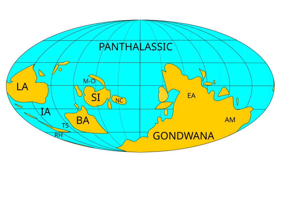
In the Ordovician, the continents sat in unfamiliar places. Most of the southern landmasses were assembled into one giant continent, Gondwana, which stretched from the equator toward the South Pole. India was part of Gondwana, and what is now the high Himalaya formed the northern continental shelf of the Indian portion, a stable passive margin facing an ancient ocean. Paleomagnetic data, as Trond Torsvik and colleagues and the broader literature have established, place this Tethyan Himalayan margin firmly at the northern edge of cratonic India through the early Paleozoic, in tropical latitudes consistent with the warm-water carbonates the rock preserves. The northern margin of India is reckoned to have stayed remarkably stable, with little rotation or deformation, from the Early Ordovician all the way to the Eocene collision.
The ocean off that shelf belonged to the Tethyan family of seaways that occupied the gap between Gondwana and the continental fragments drifting north of it across the Paleozoic and Mesozoic. The exact naming is a point of technical care rather than dispute: the Ordovician ocean bordering India here predates the better-known Neo-Tethys that India would later cross, and is often labelled the Proto-Tethys or simply an early Tethyan ocean. The IUGS uses the general phrase “an ancient Tethyan Ocean.” On that shelf, far from any future mountain, the summit limestone accumulated grain by carbonate grain.
India’s long journey north
For hundreds of millions of years, plate motion ferried India northward across the closing Tethys. The decisive event came in the Cenozoic. Several independent lines of evidence converge on India beginning to collide with Asia at roughly 55 million years ago: the cessation of marine sedimentation along the suture zone, a sharp slowdown in the rate of plate convergence, the first appearance of Asian-derived debris in Himalayan basins, and paleomagnetic reconstructions of the two plates’ positions. The IUGS site description and the wider literature both use the 55-million-year figure for the onset of collision, while noting that the full effects of that collision unfolded over the following tens of millions of years. The round 55-million-year figure and the 52-million-year value used in some plate-motion studies derive from different datasets and reference points; the discrepancy is one of calibration, not of fundamental disagreement that a collision occurred in the Early Eocene. The precise date and style of first contact remain genuinely debated. Jonathan Aitchison and colleagues, for instance, have argued for a two-stage process in which India first met an intra-oceanic island arc around 55 million years ago and only welded to Asia proper closer to 35 million years ago. The science here is unsettled in its details, and honest accounts say so.
The arithmetic of the collision is staggering and revealing. Plate reconstructions indicate that India and Asia have converged by a great distance since first contact, yet the crustal shortening measurable at the surface accounts for substantially less. Estimates of when that first contact occurred vary from about 55 to 52 million years ago depending on the dataset, and the discrepancy in the bookkeeping holds whichever figure one adopts. As Douwe van Hinsbergen and colleagues put it in a 2012 study in the Proceedings of the National Academy of Sciences, “Since 52 Ma, the two plates have converged up to 3,600 ± 35 km, yet the upper crustal shortening documented from the geological record of Asia and the Himalaya is up to approximately 2,350-km less.” The missing distance drives active research. Van Hinsbergen’s team proposed the Greater India Basin hypothesis, in which a wide tract of thinned Indian continental and oceanic lithosphere was subducted beneath Tibet between roughly 50 and 25 million years ago, swallowing much of the shortfall. Whatever the final bookkeeping, the consequence at the surface was the same. The leading edge of India, including its old Ordovician shelf, was rammed against and partly under Asia, then folded and stacked skyward to build the highest mountains on Earth.
The Qomolangma detachment and the Yellow Band
The way the rock was stacked left a sharp signature on Everest, and it is visible as a change from summit to base. Below the unmetamorphosed summit limestone lies the Yellow Band, a conspicuous layer of pale, weathered marble and calc-silicate rock that rings the upper mountain and gives it the distinct band of colour climbers use as a landmark. Between the summit limestone and the Yellow Band runs the Qomolangma detachment, a low-angle fault that slides younger rock over older. Sakai and colleagues located an exposure of this fault in 2005 at about 8,520 metres, at the base of the feature climbers call the First Step on the northeast ridge. There, strongly fractured but unmetamorphosed Ordovician limestone sits directly on metamorphosed Yellow Band rock, the two separated by a sharp fault plane with a zone of crushed rock, or breccia.
The Qomolangma detachment is the upper strand of the South Tibetan Detachment System, a network of north-dipping low-angle normal faults that runs the length of the Himalaya. This is one of the genuine curiosities of the range. Even as India drove relentlessly into Asia under compression, the upper crust along the crest of the Himalaya was being pulled apart along these extensional faults. Geologists reconcile the paradox with models such as channel flow, in which a hot, weak slab of middle crust was squeezed southward and extruded toward the surface between the South Tibetan Detachment System above and the Main Central Thrust below, behaving over geological time like a viscous fluid forced from a tube. Whether the detachment acted purely as an extensional fault or partly as a roof thrust is still argued in the structural-geology literature, and competing models such as channel flow and tectonic wedging are tested against field data along the range.
Paul Myrow and colleagues, in a 2009 study in the Geological Society of America Bulletin, traced the stratigraphy across these faults and showed that the rocks between the Qomolangma and Lhotse detachments, the unit historically called the Everest Series, still preserve sedimentary textures matching Cambrian strata more than 1,000 kilometres away in northern India. They also pinned down a striking detail: the base of the summit pyramid, at the foot of the so-called Third Step, is a 60-metre-thick bed of fossil microbial rock called thrombolite, the lithified remains of ancient bacterial mats, whose top crops out only about 70 metres below the summit. A climber standing near the top of the world is within a stone’s throw of a fossilized microbial reef.
The timing of the metamorphism beneath the detachment has been dated directly. Sakai’s team measured argon-isotope ages on the mineral muscovite from the Yellow Band and found two events, at about 33.3 and 24.5 million years ago. The older records the peak of a Barrovian-type metamorphic episode, the Eo-Himalayan event, when the rock was buried and heated deep in the growing mountain belt. The younger records a later, decompressional high-temperature event as the rock began to be exhumed. Fission-track ages on the minerals zircon and apatite from the same rock, around 14 million years, show that the hanging wall of the detachment then cooled rapidly, from roughly 350 to 130 degrees Celsius over a short interval in the mid-Miocene, as the fault carried it toward the surface.
Why the summit limestone is barely cooked
Here is the elegant part. The Yellow Band below the detachment was metamorphosed, recrystallized by heat and pressure into marble, its original fossils largely erased. The summit limestone above it was spared that fate, or nearly so, and it still holds recognizable fossils. The fault between them is the reason. It juxtaposed rock with two very different histories, sliding a slice that stayed relatively cool and shallow over a slice that had been cooked deep in the crust. That is why a climber can stand at 8,848 metres and, in principle, pick up a slab in which the outlines of 460-million-year-old sea creatures remain legible — a slice of seafloor that escaped the cooking its neighbour endured.
Still rising: how fast, and why
The Himalaya are not a finished monument. They are actively growing, and Everest with them. Getting the numbers right matters here, because the popular shorthand that “Everest grows about four millimetres a year” compresses several different measurements into one figure and obscures more than it reveals.
What the geodesy shows
India and Asia are still converging. As Roger Bilham and colleagues reported in Nature in 1997, “approximately one-third of the present-day convergence rate between India and Asia (58 ± 4 mm yr⁻¹)” is taken up across the Himalaya; the same study measured Himalayan contraction at about 17.5 millimetres per year and slip of India beneath southern Tibet at roughly 20.5 millimetres per year on the Main Himalayan Thrust, the great fault that dips under the range. That horizontal shortening is converted into vertical motion. Spirit-leveling and InSAR satellite data across Nepal record surface uplift of two to three millimetres per year in the Lesser Himalaya, rising to roughly four to seven millimetres per year in the Greater Himalaya.
Those figures describe the mountain front broadly. For the summit region itself, the picture is more specific and more interesting. The 2024 study led by Xu Han, Jin-Gen Dai, and Matthew Fox notes that GPS data give Chomolungma a short-term rock-uplift rate of about 2 millimetres per year, while long-term thermochronology records roughly 1 millimetre per year. The summit appears to be rising faster now than its long-run average, and that discrepancy is a real scientific puzzle rather than a rounding error. Some of the apparent change in any given decade is also offset by earthquakes, which release accumulated strain in seconds.
The 2024 river-piracy finding
That gap between short-term and long-term uplift is what a notable 2024 paper set out to explain. Writing in Nature Geoscience, Han, Dai, Fox and their co-authors proposed that part of Everest’s anomalous height comes from isostatic rebound triggered by a river. Everest stands about 250 metres taller than the next-tallest Himalayan peaks, an outlier that ordinary along-strike tectonics does not easily account for, given how uniform the range is in its setting. The authors modeled the drainage of the Kosi River and its major tributary the Arun, which cuts a spectacular gorge through the range north and east of Everest, dropping some seven kilometres in elevation over a span of only about 35 kilometres.
Their best-fit reconstruction suggests that the Arun captured a river system to its north about 89,000 years ago, an event geologists call river piracy. The enlarged river then incised its gorge much faster, stripping mass off the surrounding landscape. As that mass was removed, the crust beneath floated upward to compensate, the way a boat rises when cargo is unloaded. This flexural isostatic rebound, the authors estimate, lifts Everest at an additional 0.16 to 0.53 millimetres per year and has contributed on the order of 15 to 50 metres of extra elevation over the life of the gorge, an amount they frame as roughly 10 to 50 percent of the current GPS-derived rock-uplift rate. The neighbouring giants Lhotse and Makalu, the world’s fourth and fifth highest peaks, received a similar boost.
This is a modeling result, not a direct measurement, and the paper is careful to say so. It presents the river-capture contribution as a partial mechanism layered on top of the fundamental tectonic cause, not a replacement for it; the authors state plainly that crustal thickening and rock uplift driven by the collision remain the basic reason Everest is high. The fair takeaway is that Everest’s height has at least two ingredients: the deep tectonic engine of the India–Asia collision, plus a more recent, more local isostatic top-up from erosion.
Erosion, isostasy, and a mountain that has long been high
The interplay of uplift and erosion is the constant background of the range’s life. Rivers and glaciers strip material away even as tectonics pushes it up, and the balance between the two governs how the topography evolves. The principle that valley incision can actually raise neighbouring peaks, by unloading the crust and letting it rebound, goes back to L. R. Wager in 1933 and David Montgomery in 1994; the 2024 study applies it with modern modeling. The same logic implies that erosion, not tectonics alone, sets both a ceiling and a character on how high mountains can stand.
One consequence is that the Everest region has been high for a very long time. Aude Gébelin and colleagues, in a 2013 study in Geology, used the hydrogen-isotope composition of minerals deformed in the South Tibetan Detachment shear zone as a paleoaltimeter. Because the isotopic fingerprint of rain and snow changes systematically with elevation, minerals that exchanged with high-altitude precipitation carry a record of how high the land stood. Their analysis concluded that the Everest area already reached mean elevations of at least 5,000 metres by the late Early Miocene, roughly 15 to 17 million years ago. The Everest region was already among the planet’s high places long before any human walked the Earth, and the marine fossils on the summit had by then been hoisted most of the way to where they sit today.
A note on measuring the unmeasurable
The precision of “8,848.86 metres” hides a long and contentious history. The mountain was first identified as the world’s highest by the Great Trigonometrical Survey of British India in the 1850s, when computations from observations made across the Gangetic plain put “Peak XV” at about 8,840 metres; the calculation is widely credited to the Bengali mathematician Radhanath Sikdar. A 1954 Survey of India figure of 8,848 metres became the textbook standard for decades. A 1999 American expedition using GPS reported 8,850 metres, including the snow cap. A 2005 Chinese survey, measuring to the rock beneath the snow, reported 8,844.43 metres and ignited a years-long disagreement over whether the official height should include the summit snow and ice. The 2020 joint survey resolved the dispute diplomatically and technically at once: surveyors from both countries reached the summit, used global navigation satellite systems together with ground-penetrating radar to separate rock from snow, tied their measurements to sea level through long survey lines, and agreed on the single figure of 8,848.86 metres. The number is the most accurate ever produced, and, because the mountain keeps moving, it is also already slightly out of date.
A lineage of seeing clearly: Leonardo, Steno, and deep time
The fossils on Everest are not a riddle to modern science. They are a confirmation. The line of reasoning that turned mountaintop seashells from a theological curiosity into hard evidence for the Earth’s history deserves tracing, because it shows the core insight was within reach centuries before plate tectonics had a name or a mechanism.
Leonardo and the petrified shells

Return to the cold open. In folios 8 through 10 of the Codex Leicester, the notebook he compiled between about 1504 and 1510, Leonardo da Vinci worked methodically through the problem of marine shells found far inland and high above the sea. The two explanations of his day both failed his tests. If a single great Flood had carried the shells uphill, the receding water should have washed them back down, since rain flows toward the sea rather than away from it. And the rival idea, that fossils grew spontaneously inside rock, ignored the evidence: many shells showed growth lines, were sorted by size into distinct sedimentary layers, and bore the borings of other organisms, all marks of animals that had genuinely lived and died. His conclusion, written plainly, was that where there is now land there had once been sea, and the shells were the remains of creatures buried before the rock was lifted. Leonardo had no mechanism for the lifting. He had the observation exactly right, and he recorded it more than three centuries before geology became a formal science.
The Codex Leicester itself survived as the only one of Leonardo’s notebooks still in private hands. It passed through Italian collectors, was bought by Thomas Coke, Earl of Leicester, in the early eighteenth century, and in 1994 was sold at auction for just over 30 million dollars, the most ever paid for a manuscript at the time. The pages that preserve Leonardo’s reasoning have themselves outlasted nearly every other trace of his scientific notebooks.
Steno’s tongue stones and the law of superposition
The next decisive step came from the Danish anatomist Nicolas Steno. In 1666 the Grand Duke of Tuscany had the head of a large shark, caught off Livorno, sent to Steno for dissection. Steno was struck by how closely the shark’s teeth resembled the triangular stones called glossopetrae, or tongue stones, found embedded in rocks across the Mediterranean and widely believed to have fallen from the sky or grown in the ground. He argued the obvious conclusion that others had resisted: the tongue stones were fossilized shark teeth, identical in form to the real ones in front of him, changed in chemistry but not in shape.
In his 1669 work, with the long Latin title abbreviated to Prodromus, Steno generalized the insight into the foundations of geology. He reasoned that a solid object found inside another solid, a tooth inside rock, a crystal inside a vein, must have solidified at a different time from its container, and that this principle could be used to read the order of events in the Earth. From it he drew the law of superposition: in an undisturbed stack of sedimentary layers, the lower beds are older than the upper ones. With superposition, fossils became a record that could be read in sequence, and rock layers became the pages of a history book. The University of California Museum of Paleontology summarizes Steno as the figure who turned the puzzle of solids-within-solids into a method for unravelling the Earth’s structure and history.
From mountaintop fossils to plate tectonics
Leonardo and Steno could establish that mountain rocks had once lain beneath the sea. What neither could supply was the force that raised them. That arrived in the twentieth century with the theory of plate tectonics, and marine fossils lifted onto high ground became one of its supporting observations. NASA notes that the presence of marine limestone and fossils at the top of the Himalaya was among the pieces of evidence cited as plate tectonics was first being argued. The pattern is not unique to Everest. Marine fossils and whole shell beds occur high in the Andes; ammonites weathered out of the Himalaya are venerated in Nepal as shaligram stones from the Kali Gandaki valley. Everest is simply the most extreme case: the highest exposed rock anywhere on the planet, and it is fossil-bearing marine limestone. The seashells on Mount Everest close a circuit of reasoning that runs from a Renaissance notebook through a seventeenth-century shark dissection to modern satellite geodesy, and every link in it has held.
Recognized as a world heritage of geology
On 28 October 2022, at the event marking its 60th anniversary in Zumaia, Spain, the International Union of Geological Sciences named the Ordovician marine rocks of Mount Everest one of the First 100 IUGS Geological Heritage Sites. The IUGS citation describes the summit as a tropical Middle Ordovician limestone bearing brachiopods, conodonts, and crinoids that lived during the Great Ordovician Biodiversification Event, rock deposited in an ancient Tethyan ocean and thrust skyward when India collided with Asia about 55 million years ago. The selection drew on more than 200 specialists from nearly 40 countries.
The designation places Everest’s old seafloor in the company of Siccar Point, where James Hutton read deep time in an unconformity; the Great Unconformity at the Grand Canyon; and the Chengjiang fossil beds of the Cambrian explosion. These are the places that taught the world how the Earth works. Everest earns its spot for what the rock at the top of it records, quite apart from the mountain’s height.
The roof of the world is a fossilized seafloor, and it is still rising.
Frequently asked questions
Was Mount Everest once underwater?
Yes. The rock at Everest’s summit is the Qomolangma Formation, a marine limestone that formed on the floor of a warm, shallow tropical sea roughly 450 to 470 million years ago, during the Ordovician period. That seafloor sat on the northern continental shelf of India, then part of the supercontinent Gondwana. It was later carried north and lifted nearly nine kilometres when India collided with Asia.
How old are the fossils on Mount Everest?
The summit limestone is Middle Ordovician, dated by conodont microfossils to the upper Darriwilian stage, roughly 460 to 470 million years old. The IUGS summarizes the age as about 450 million years. Some associated rocks lower in the Everest succession reach down toward the Cambrian–Ordovician transition and are older still.
What kinds of fossils are found on Everest?
The summit limestone contains fragments of trilobites, crinoids (sea lilies), and ostracods (tiny shelled crustaceans), identified in a 2005 study in the journal Island Arc. Equivalent rocks at lower altitude in southern Tibet also yield brachiopods, conodonts, nautiloids, and gastropods. The fossils are mostly broken skeletal debris rather than whole animals, swept together on an ancient carbonate seafloor.
How did seashells get to the top of a mountain?
Plate tectonics. The fossils formed on a tropical seafloor on India’s northern margin. As India drifted north and collided with Asia beginning about 55 million years ago, that former seabed was thrust, folded, and stacked upward to build the Himalaya. On Everest, a low-angle fault called the Qomolangma detachment carried the relatively uncooked summit limestone over the metamorphosed Yellow Band, preserving its fossils nearly nine kilometres above sea level.
Is Mount Everest still growing?
Yes. India and Asia are still converging at about 58 millimetres per year, roughly a third of which is absorbed across the Himalaya, producing surface uplift of several millimetres per year. A 2024 study in Nature Geoscience argued that river erosion in the nearby Arun gorge adds an extra isostatic rebound of about 0.16 to 0.53 millimetres per year to Everest specifically. Earthquakes can offset this; the 2015 Gorkha earthquake is thought to have lowered the summit by roughly 2.5 centimetres, an amount close to the limit of what the satellite measurements could resolve.