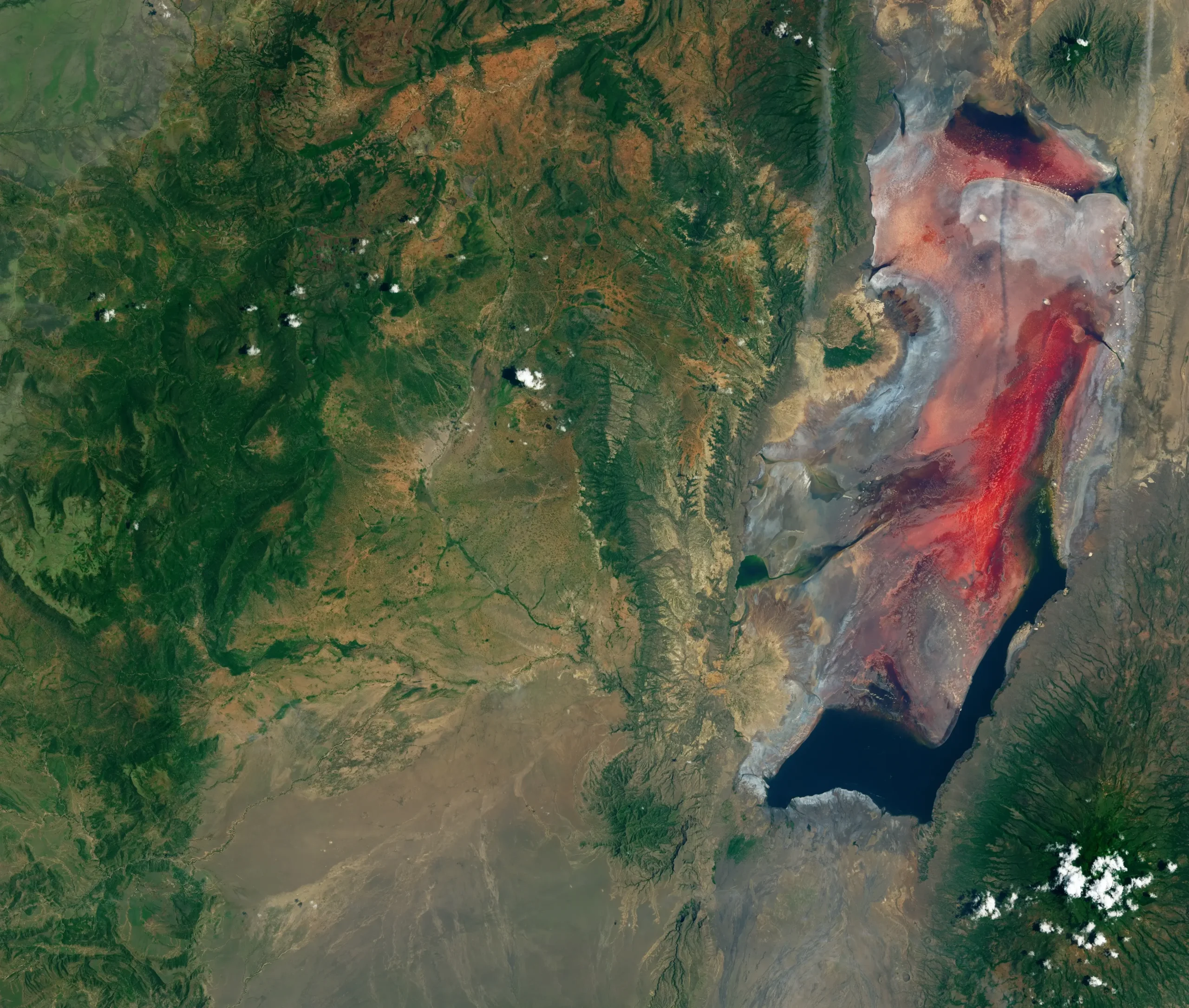
On a hillside in West Turkana, late-Miocene mudstones tilt toward the sky in alternating bands of rust and bone. Christian Rowan has been mapping these strata for years, climbing the same gullies where Kamoya Kimeu’s “Hominid Gang” once knelt with dental picks, brushing 1.5-million-year-old vertebrae out of the dust. From the ridge at Lothagam, you can look east across an arid plain studded with extinct cinder cones toward the brackish, jade-green expanse of Lake Turkana, the world’s largest desert lake. It is a landscape that looks finished, geology at rest. It is not.
Roughly thirteen kilometres beneath Rowan’s boots, the crust of the African continent has been stretched and necked so thin that it now sits at the threshold where continents do not merely deform but tear. A study he led, published on 23 April 2026 in Nature Communications, reports that the crystalline crust along the Turkana Rift axis has thinned to about 12.7 km, down from more than 35 km outside the rift: a measurement that puts this stretch of northern Kenya into a tectonic phase that has never before been documented in an active continental rift on Earth. Crustal necking, geologists call it: the moment when stretching localizes, weakens, and becomes irreversible.
The same forces that will, over millions of years, lower these plains beneath an arm of the Indian Ocean are the forces that buried Turkana Boy, sealed Lucy in volcanic ash, and built the thickest, most continuous record of human evolution anywhere on the planet. The geological process that will erase this landscape is the one that preserved us.
A continent unzipping from the Red Sea to the Zambezi
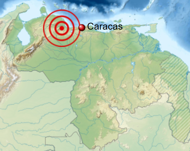
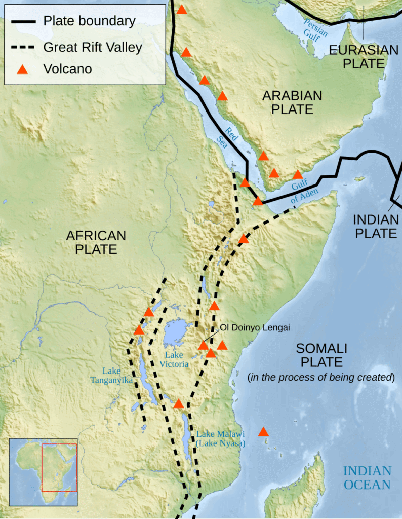
The East African Rift System is the largest active continental rift on Earth, a roughly 6,400-kilometre fracture extending from the Afar Depression of Ethiopia south through Kenya, Tanzania, and Malawi to the Mozambique coast. It is the surface trace of a slow-motion divorce: the Nubian plate, which carries most of the African continent, and the smaller Somali plate to its east are pulling apart at rates that vary by latitude but average a few millimetres per year, slower than a fingernail grows.
In the Turkana segment, those rates have been measured by GPS at roughly 4.7 mm per year, the figure Rowan and his colleagues use. Further north, where the rift meets the Red Sea Rift and the Gulf of Aden Rift at the Afar triple junction, the Arabian plate is retreating from Nubia at about 1 to 1.5 cm per year, fast enough that the Red Sea is already, by most definitions, a young ocean. South of Lake Turkana, the rift splits into two limbs: the Eastern or Gregory Rift, which runs through the Kenyan highlands past Lake Naivasha and the geothermal field at Olkaria, and the Western or Albertine Rift, which arcs through the deep lakes of the Albertine basin, Tanganyika, Kivu, Edward, and down to Lake Malawi.
Those lakes are not incidental scenery. They sit in the structural troughs the rift has carved, and they hold something like a quarter of all the unfrozen surface freshwater on Earth. The African Great Lakes together hold about 25% of the world’s unfrozen surface fresh water and harbour roughly 10% of the world’s fish species, figures the UK Hydrographic Office reproduced in a September 2023 note on regional navigation. When geologists talk about the rift “drowning” the Horn of Africa, they are not speaking metaphorically. The plumbing for a future ocean is already in place.
What “necking” means, and why Turkana is the only place on Earth showing it
Continental rifting is usually described in three acts. In the first, the crust simply stretches, broad, brittle deformation along normal faults that drop blocks into grabens but leave the continent fundamentally intact. In the second, necking, the stretching localizes into a narrow zone where the crust thins disproportionately, like the elongating middle of a piece of saltwater taffy pulled at both ends. In the third, oceanization, the necked crust ruptures, mantle melt rises into the gap, and new oceanic crust accretes on either side of a fresh spreading ridge.
Most active rifts on Earth, the Rio Grande, the Baikal Rift, the Rhine Graben: are stuck in the first act. The Atlantic margins of North America and West Africa are necked margins long since gone to ocean. The middle act, the one in which a continent crosses the threshold of no return, has been observable only in ancient rocks. Until now.
Using high-resolution seismic-reflection data acquired with industry partners and the Turkana Basin Institute, the field organization founded by the late paleoanthropologist Richard Leakey, Rowan and colleagues at Columbia University’s Lamont-Doherty Earth Observatory mapped the depth of the top of crystalline basement along and across the Turkana Rift. The numbers are the headline. Outside the rift, the crystalline crust is more than 35 km thick; along the rift axis, it has been thinned to 12.7 ± 2.8 km. The implied stretching factor, β, is between 1.9 and 3.1: well into the range that, on rifted margins worldwide, marks the transition from continental thinning to incipient breakup.
“We found that rifting in this zone is more advanced, and the crust is thinner, than anyone had recognized,” said Christian M. Rowan, a PhD student at Lamont-Doherty and the study’s lead author, in the press release from Columbia Climate School. “Eastern Africa has progressed further in the rifting process than previously thought.”
His co-author Anne Bécel, a geophysicist at Lamont-Doherty, framed the significance bluntly in Eos: “This is one of the unique places on Earth where you can see a continental rift. The East African Rift System has been studied for a very long time by geologists to really learn about our planet and how continents break apart, and then transpose that to mid-ocean ridges where oceanic plates spread apart.” In the Columbia release she added that the rift has “reached that critical threshold” of crustal breakdown: “We think this is why it is more prone to separate.”
A third detail in the paper deserves attention: the onset of necking is dated to roughly 4 million years ago, following a major pulse of volcanism in Turkana. That date matters, because it sits squarely on top of the hominin record.
“It challenges some of the more traditional ideas of how continents break apart,” Rowan said. The team also found evidence of an earlier, failed rifting event, the Mesozoic-to-early-Cenozoic Central African Rift System (CARS), that pre-weakened the Turkana crust. The interval of less than 17 million years between the end of CARS rifting and the magmatism that followed the onset of the present rift was too brief for lithospheric healing, leaving a pre-existing scar that the current rift has exploited. Co-author Folarin Kolawole, also at Lamont, put the moment in perspective: “In essence, we now have a front row seat to observe a critical rifting phase that had fundamentally shaped all rifted margins across the world.”
The heartbeat under Afar
If Turkana is the unzipping seam, Afar is the engine room. Six hundred kilometres to the north, in the Danakil Depression of Ethiopia, three rifts meet: the Red Sea, the Gulf of Aden, and the northern end of the East African Rift. Above the junction, the surface sinks more than 100 metres below sea level, salt pans bake under temperatures regularly exceeding 45 °C, and basaltic volcanoes like Erta Ale host one of the planet’s few persistent lava lakes: a feature that, according to the Smithsonian Institution’s Global Volcanism Program, has been more or less continuously active since at least 1967 and possibly since 1906.
Geologists have long suspected that a hot upwelling of mantle, a plume, sits beneath Afar, driving the extension and the volcanism. What they did not know, until last year, was the plume’s structure or its tempo.
On 25 June 2025, a team led by Earth scientists at the University of Southampton published in Nature Geoscience the most detailed picture yet of the Afar upwelling. Lead author Dr Emma Watts, who conducted the work at Southampton and is now at Swansea University, and her co-authors analysed the geochemistry of more than 130 young volcanic samples spanning the three rifts of the triple junction, combining the data with seismic constraints and statistical modelling. What emerged was not a single, uniform column but an asymmetric, chemically banded upwelling whose composition repeats across the rift system “like geological barcodes.”
“We found that the mantle beneath Afar is not uniform or stationary: it pulses, and these pulses carry distinct chemical signatures,” Watts said in the Southampton press release. “These ascending pulses of partially molten mantle are channelled by the rifting plates above. That’s important for how we think about the interaction between Earth’s interior and its surface.”
The metaphor the team reached for was visceral. Tom Gernon, Professor of Earth Science at Southampton and a co-author of the study, told the press: “The chemical striping suggests the plume is pulsing, like a heartbeat. These pulses appear to behave differently depending on the thickness of the plate, and how fast it’s pulling apart. In faster-spreading rifts like the Red Sea, the pulses travel more efficiently and regularly like a pulse through a narrow artery.”
The implication is that mantle dynamics in a rifting region are not autonomous. They are filtered by the geometry of the lithosphere above them: an idea that Dr Derek Keir, an associate professor at Southampton and the University of Florence, summarized in the same release: “We have found that the evolution of deep mantle upwellings is intimately tied to the motion of the plates above. This has profound implications for how we interpret surface volcanism, earthquake activity, and the process of continental breakup.”
Read alongside the Turkana necking finding, Watts’ result fills in a piece of the same picture from the opposite side. The crust is thinning passively in the south because the mantle is pumping actively in the north, and the two ends of the system are talking to each other. Geoscopy readers interested in how such deep upwellings connect to even larger structures may want to revisit LLSVPs: Hidden Giants at Earth’s Core–Mantle Boundary, which sits one layer further down in the same plumbing.
A rift caught in the act: the 2005 Dabbahu episode
Theories of how continents break apart used to rest almost entirely on inference from old, dead margins: the salt-buried passive edges of the Atlantic, or seismic profiles across the Norwegian shelf. Then, between 14 September and 4 October 2005, the Afar rift gave geologists something they had never had before: a continental rupture happening live.
In a sequence reconstructed by Tim Wright (then at Oxford, now Leeds), Cynthia Ebinger (then at Royal Holloway, later Rochester), Juliet Biggs, Atalay Ayele, Gezahegn Yirgu, Derek Keir, and Anna Stork, and published in Nature in July 2006, a 60-kilometre-long magmatic segment of the Afar rift ruptured in less than a fortnight. Magma forced its way upward through the crust as a near-vertical sheet, a dyke, between roughly 2 and 9 km depth, prying open the segment by as much as 8 metres at its widest and pumping roughly 2.5 cubic kilometres of molten rock into the plate boundary. 163 earthquakes of magnitude greater than 3.9 rattled the Afar floor. On 26 September, an explosive fissural eruption opened a 500-metre-long vent at Da’Ure, on the flank of Dabbahu volcano.
What made the 2005 event historically important was not just its scale, comparable in volume to the entire decade-long Krafla rifting episode in Iceland in 1975–1984, but the speed with which it was captured. Interferometric satellite radar from the European Space Agency’s Envisat mission, combined with on-the-ground seismology by Addis Ababa University and a hurriedly deployed international team, allowed Wright and colleagues to produce a three-dimensional picture of a continental dyke intrusion within months. Their conclusion was that the rift’s along-axis segmentation is maintained not by faulting but by repeated magma injection, the same process that maintains slow-spreading mid-ocean ridges. Continental breakup, in other words, looks like seafloor spreading rehearsed on land.
Subsequent work by Ian Hamling and colleagues (Geophys. J. Int., 2009) tracked more than a dozen further dyke intrusions in the same Manda Hararo–Dabbahu segment through 2009, showing that Afar’s rifting cycle continues in repeated pulses. Each one widens the segment by metres in days, then quiets for years. Over millions of such episodes, an ocean basin is built. Catching those pulses early — and telling a magma-driven intrusion apart from purely tectonic faulting — is one frontier where machine learning is reshaping seismology, as Geoscopy has covered in How AI Is Deciphering Micro-Seismicity to Forecast Earthquakes and Eruptions.
The cradle and the rift are the same place
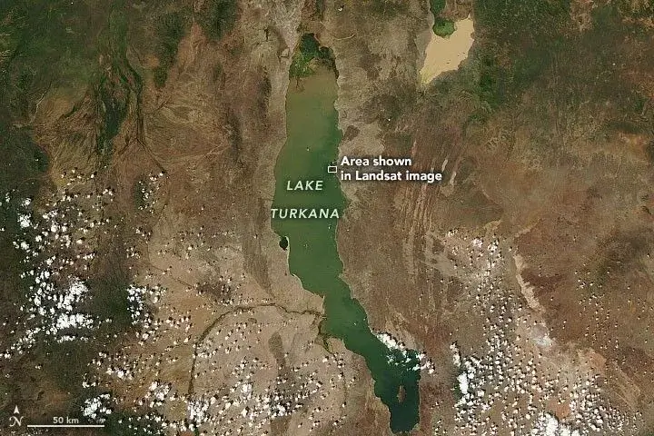
The hominin fossil record reads, with a few crucial exceptions, like a list of localities along the East African Rift. Lucy, Australopithecus afarensis, catalogue number AL 288-1, was found by Donald Johanson on 24 November 1974 at Hadar, in the Awash Valley of Ethiopia’s Afar region, in sediments dated to about 3.2 million years old. Turkana Boy, KNM-WT 15000, the most complete early human skeleton ever recovered, was spotted by Kamoya Kimeu on the dry bed of the Nariokotome River on the west shore of Lake Turkana in 1984, in tuffs dated to roughly 1.6 million years old; he was a Homo erectus juvenile about eight or nine years old at death, whose anatomy rewrote our understanding of body proportions in early Homo. The Leakey family’s decades of work at Olduvai Gorge in Tanzania, on the Eastern Rift’s flanks, established the deep antiquity of stone toolmaking. Across the Turkana Basin alone, more than 1,200 hominin fossils spanning 4 million years have been recovered.
Why here? The conventional answer was selection: that the rift’s mosaic of habitats, lake-margin, savanna, woodland, drove the diversification of our lineage. Rowan and his colleagues, in the same 2026 paper that announced the necking finding, propose something more deflationary, and harder to dismiss. The necking of the Turkana crust, beginning about 4 million years ago, dropped the basin floor and created the closed, subsiding lake system in which fine-grained sediments accumulated continuously, on top of regular ashfall from nearby volcanoes. Those ashes provided the dateable horizons that make Turkana’s record so unusually crisp. The same process that thinned the crust filled the basin with a near-perfect preservation matrix.
“The conditions were right to preserve a continuous fossil record,” Rowan said in the Columbia Climate School press release. The Turkana Rift, in this telling, may not have been a uniquely productive cradle of human evolution so much as a uniquely good archive of it.
That is a quietly radical reframing. It does not deny that East African environments shaped our ancestors: climate-driven mosaics surely mattered, and Bécel notes that rifting processes connect to climate, vegetation, and landscape evolution. But it removes some of the teleology from the story. The fact that hominin bones lie thick on the ground in northern Kenya and Ethiopia is, in part, a side effect of the same rifting that is now visibly tearing the continent apart.
What the East African Rift will look like in 5–10 million years
The end-state is not in doubt; only the timing. Once the Turkana crust ruptures and oceanization begins, magma rising freely into the gap to form new basaltic seafloor, water from the Indian Ocean will pour southward through the Afar lowlands, then westward and south as the rift floor subsides further. The Red Sea, which is already a narrow proto-ocean, will widen. The Gulf of Aden, fed by ocean to its east, will push further inland. Within a few million years, a long, narrow seaway will separate a new Somali microcontinent, eastern Ethiopia, Somalia, Kenya, and parts of Tanzania, from the rest of Africa, much as the Red Sea separates Arabia today.
How long? The Rowan paper and its accompanying Columbia release are careful with the number. “It will take a few million more years before necking gives way to oceanization, the next stage in rifting, when magma will surge through the cracks and create a new seafloor for water that pours in from the Indian Ocean to the north,” the Columbia Climate School press release states. Across the broader literature, the consensus window is on the order of 5 to 10 million years for a Red Sea–scale ocean to be born along the Turkana–Afar axis. The Red Sea itself is the closest active analogue: continental rifting between Arabia and Nubia began essentially simultaneously along its full length at roughly 23 million years ago (Bosworth, Geological Evolution of the Red Sea, 2015), and the basin still hosts only a narrow, embryonic spreading ridge. Plate-motion work summarized by the geologist Ken Macdonald of UC Santa Barbara puts Nubia–Somali separation at roughly half a centimetre per year, with Arabia leaving Nubia faster: about 1 to 1.5 cm per year. At those rates, every human generation widens the rift by less than a metre. Across the entire history of our species, the rift has crept apart by perhaps a couple of kilometres.
That is what makes the language around East Africa’s “splitting” so easily abused. The continent is splitting, but not on any timescale that requires Nairobi to evacuate. The relevant unit is the megayear, not the news cycle.
Living on a splitting continent: geothermal energy, volcanism, and ground fissures
The slow part of the story is the new ocean. The fast part is everything else.
Kenya’s Olkaria geothermal complex, in Hell’s Gate National Park on the floor of the Eastern Rift, draws its steam from reservoirs that exist precisely because the crust here is thinned and the mantle is close. The Olkaria stations had a combined installed capacity of 810.3 MW as of 2020 (KenGen data, with Olkaria I Unit 6 adding 83.3 MW in 2022), and geothermal supplied 47% of Kenya’s electricity generation in 2023: the leading source in the country’s mix, according to the IEA’s Kenya 2024 Energy Policy Review. Kenya’s Vision 2030 strategy calls for further geothermal expansion at Menengai, Eburru, and Suswa, with national theoretical potential put at 10,000 MW (10 GW) in the same IEA review, distributed across rift-valley prospects. That entire industry is a direct dividend of the same rifting that will, in the very long run, drown it.
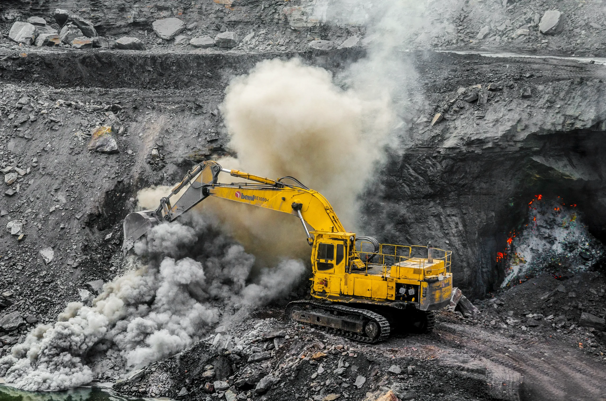
The hazards are the other side of the same coin. Nyiragongo, the steep-sided stratovolcano above Goma in the Democratic Republic of the Congo, sits on the Western Rift. The 17 January 2002 flank eruption caused, according to Komorowski and colleagues (Cambridge University Press, Global Volcanic Hazards and Risk, 2015), “about 470 injuries and about 140 to 160 deaths,” mostly from CO₂ asphyxiation and the explosion of a fuel station overrun by lava. On 22 May 2021, with the city’s volcano observatory crippled by World Bank funding cuts that had taken its monitoring offline, Nyiragongo erupted again with almost no warning. Lava reached the northern outskirts of the city of two million; at least 32 people died, more than 400,000 were displaced, and post-eruption earthquakes destroyed homes and disrupted water supply for weeks. Subsequent reanalysis by Delphine Smittarello and colleagues, published in Nature in 2022, showed that the underlying dyke had propagated at less than 500 metres depth, passing as shallow as 450 metres beneath Goma, closer than monitors realized at the time, and closer than the city’s residents had any way of knowing.
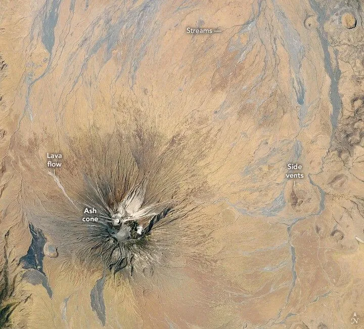
Ol Doinyo Lengai, on the Tanzanian floor of the rift south of Lake Natron, is the only volcano on Earth currently erupting natrocarbonatite lava:a sodium- and potassium-rich melt that emerges at temperatures of around 500–600 °C, roughly half that of basalt, and is so fluid it pours like motor oil. The lava is jet-black when fresh and turns white as it absorbs atmospheric moisture, giving the cone an unearthly piebald appearance. It is the most distinctive surface expression of the magmatic system that drives the slow extension of the Gregory Rift.
In northern Ethiopia, Erta Ale and its neighbours along the Danakil have hosted persistent lava lakes for more than a century and continue to erupt; a renewed phase of intra-caldera activity since October 2023 has refilled former pit craters and produced new lava flows for the first time since a 2017 flank eruption drained the long-lived lakes.
And then there are the surface fissures. In March 2018, after weeks of heavy rain and minor tremors, a several-kilometre-long crack opened across the Mai Mahiu–Narok road in Kenya’s Rift Valley Province, swallowing a section of highway and destabilising homes. Most geologists, including the Kenya Geological Survey and earthquake scientist Wendy Bohon, concluded that the immediate trigger was erosional piping through soft volcanic ash on a pre-existing fault rather than tectonic rupture per se. But the underlying fault system is a Gregory Rift structure, and a 2023 paper in Scientific Reports documented 22 such ground fissures across the Kedong Basin alone, with mantle-sourced helium leaking from many of them. Whether tectonic, magmatic, or erosional, those features keep cutting roads, railways, and water mains across an active rift floor. East Africans live on top of a continent in the act of separating; the engineering consequences are immediate, even if the ocean is not. A useful comparison case from another tectonic setting is documented in Geoscopy’s coverage of Campi Flegrei: Roman Columns, Bradyseism and the Volcano Under Pozzuoli, where a similarly slow geological process makes daily life unstable.
How geologists read a splitting continent: seismic reflection, InSAR, and mantle geochemistry
The Turkana, Afar, and Dabbahu studies are part of a wider shift in how geologists are reading rifts: from the surface down through the crust into the mantle, with techniques borrowed from seismology, geodesy, and geochemistry. Active-source seismic reflection of the kind Rowan and Bécel deployed, sending acoustic pulses into the ground and listening for the echoes off subsurface layers, is the same method used to image hydrocarbon reservoirs, repurposed to look at the architecture of a breaking continent. Interferometric synthetic aperture radar (InSAR) from satellites like Envisat and Sentinel-1 lets researchers measure ground deformation to the millimetre across thousands of square kilometres, the technique that made the 2005 Dabbahu reconstruction possible.
The geochemical side of the work, exemplified by Watts and colleagues’ 2025 paper, treats erupted lavas as samples of the mantle they came from. By measuring trace elements and the isotopes of strontium, neodymium, and lead in basalts spanning the Afar triple junction, the Southampton team could reconstruct the composition of the upwelling and watch its chemistry shift as the plume interacts with rifts of different ages and spreading rates. The result is a mantle that behaves less like a featureless conveyor belt and more like a tide modulated by the shoreline above it.
These methods are converging on a picture in which rifts are not isolated tears but coupled systems, surface fault networks, magma plumbing, and deep mantle flow communicating across hundreds of kilometres. The same techniques are being applied beneath the Cascadia subduction zone, the North Atlantic margin, and ancient sutures in the deep continental interior, including the recently identified anomaly Geoscopy explored in The Northern Appalachian Anomaly: The Hot Blob Drifting East. Africa is the laboratory because it is the only place those processes can be watched as they happen.
Geologic time, human time: the rift from Lucy to a future ocean
Stand at Koobi Fora in the morning, before the heat sets in, and you can see the rift’s geometry without instruments. The basin floor is flat and grey-brown with sediment. The rift shoulders rise on either side, etched by old fault scarps. Volcanic plugs poke through the flats. The lake glitters to the west. Beneath all of this, the crystalline crust is about thirteen kilometres thick.
The numbers Rowan, Bécel, and Kolawole report this year, 12.7 km of crust, a stretching factor between 1.9 and 3.1, necking onset at roughly 4 million years ago, are quietly extraordinary because of what they signify. They mean that the continental phase of the East African Rift is, in geological terms, nearly over. Not within a human lifetime, not within a recorded civilisation, but within the span of time that separates us from Lucy. Roughly the same interval that produced our genus is, on the other end, what remains before the basin we evolved in becomes an arm of the sea.
The symmetry is structural, not poetic. The rifting that thinned the crust dropped the basin that captured the ash that buried our ancestors. We are, in a literal sense, sediments of the same process now reaching its terminus. When the necking gives way and water from the Indian Ocean finally pours south, the bones at Nariokotome and Hadar will not be lost; they will be far underground, in strata that some future geologist, if there is one, will read the way Rowan reads Lothagam. The rift will have closed its loop, from cradle to seafloor, on a timescale that does not care for the distinction.
FAQ: People Also Ask
Will Africa really split in two?
Yes, but slowly. GPS measurements show the Nubian and Somali plates moving apart at roughly 4–7 mm per year across the East African Rift, with the Arabian plate retreating from Africa across the Red Sea at about 1–1.5 cm per year. The 2026 Rowan et al. paper in Nature Communications reports that the Turkana segment has thinned its crust to roughly 13 km, the necking stage that precedes full continental breakup. The eventual outcome is a new ocean basin separating a Somali microcontinent (parts of Ethiopia, Somalia, Kenya, and Tanzania) from the rest of Africa.
How long until a new ocean forms in Africa?
On the order of 5 to 10 million years. The Columbia Climate School press release accompanying the Rowan paper states that “it will take a few million more years before necking gives way to oceanization.” The Red Sea, where continental rifting between Arabia and Nubia began about 23 million years ago and which still hosts only a narrow, embryonic spreading ridge, is the closest current analogue for what the Turkana–Afar corridor will look like.
What is the East African Rift?
The East African Rift System is a roughly 6,400-km active continental rift extending from the Afar Depression in northeastern Ethiopia south to Mozambique. It marks the boundary along which the Nubian plate (the bulk of Africa) and the Somali plate (the eastern strip) are pulling apart, with a third arm meeting the Red Sea and Gulf of Aden rifts at the Afar triple junction. It includes the Eastern (Gregory) Rift through Kenya and the Western (Albertine) Rift through the African Great Lakes.
Is the East African Rift dangerous?
On human timescales, the slow tectonics themselves are not. The associated volcanism is. Nyiragongo in the DRC killed about 140–160 people in 2002 (Komorowski et al., 2015) and at least 32 in 2021, with more than 400,000 displaced; Ol Doinyo Lengai in Tanzania erupts unique natrocarbonatite lavas; Erta Ale in Ethiopia has hosted a near-continuous lava lake for more than a century. Surface fissures, like the 2018 Mai Mahiu crack across a major Kenyan highway, also damage infrastructure, particularly after heavy rains.
Where can I see the East African Rift?
The most accessible viewpoints are along Kenya’s Eastern Rift: the escarpments around Lake Naivasha, Hell’s Gate National Park, the steaming fumaroles of the Olkaria geothermal field, and the soda lakes of Bogoria and Magadi. In Tanzania, the Ngorongoro crater complex and Lake Natron sit at the rift’s edge. In Ethiopia, the Danakil Depression and Erta Ale, with appropriate guides and security, offer the most dramatic active expression of the rift, including the Afar triple junction itself.