Introduction
It is a wet September night in 1931, and the trawler Colinda is working a patch of seabed about 40 km (25 miles) off the Norfolk coast, over the Leman and Ower Banks. Her skipper has the kind of name a novelist would reject as too obvious: Pilgrim E. Lockwood. The net comes up from roughly 120 feet, dragging the usual junk with the fish: shells, broken wood, and chunks of black compressed peat the crews call moorlog. Lockwood swings a shovel to break a lump apart and chuck it back. The shovel hits something hard. “I hear the shovel strike something. I thought it was steel,” he told a visitor who wrote it down verbatim on 14 March 1932.
Inside the moorlog sits an antler point about 21.5 cm (8.5 in) long, carved from red deer antler, its row of barbs still sharp enough to draw blood. It is a Maglemosian harpoon, the sort of weapon a Mesolithic hunter would have used to take eels or pike, direct AMS radiocarbon dating of the antler at the Oxford Radiocarbon Accelerator Unit returned an uncalibrated age of 11,740 ± 150 BP, which calibrates to roughly 13,800–13,400 cal BP: Late Glacial, near the Allerød/Younger Dryas transition. The barb morphology is classic Maglemosian, but the date sits earlier than the typical Maglemose floruit; the discrepancy is a known anomaly, and it has just come up from beneath roughly thirty-six metres of seawater. Lockwood takes it home. In 1932 the artefact is accessioned by Norwich Castle Museum as NWHCM:1932.39, the Colinda point (Norfolk Museums Service catalogue). The peat is sent for pollen analysis to the Swedish palynologist Gunnar Erdtman and the British palaeobotanist Eleanor M. Reid; the diatoms and pollen come back unmistakably freshwater (Reid & Erdtman 1933; Norfolk Museums Service catalogue; Urbanus, Archaeology Magazine, March/April 2022).
The implication is uncomfortable for a 1930s map of the world.
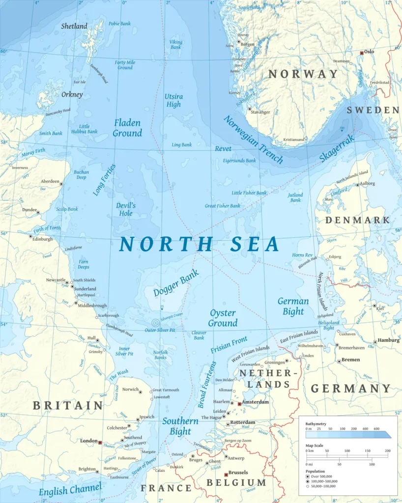
The Leman and Ower Banks are more than a fishing ground. They are the eroded surface of a country we now call Doggerland.
Doggerland is the now-submerged Pleistocene to early Holocene landmass that once joined Britain to mainland Europe across what is now the southern North Sea. It was inhabited continuously by Neanderthals and then by modern humans, and finally drowned by post-glacial sea-level rise between roughly 9,000 and 7,000 years ago. The Colinda harpoon was the first physical artefact to prove the land had been populated, rather than merely existed.
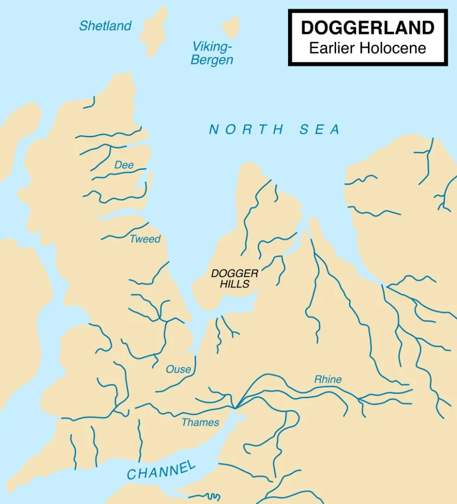
Doggerland: A Continent Under the North Sea
For most of the last glacial cycle, the southern North Sea was not a sea at all. Doggerland was the habitable post-glacial landscape that connected Britain to mainland Europe between roughly 18,000 and 7,000 years ago, before rising seas drowned it beneath what is now the southern North Sea. It was a low plain crossed by rivers, dotted with lakes and reed marsh, fringed by tundra in the cold spells and by woodland in the warm ones. The British archaeologist Bryony Coles, then at the University of Exeter, gave it a name in her 1998 paper “Doggerland: a Speculative Survey” in Proceedings of the Prehistoric Society (Coles 1998, vol. 64, pp. 45–81). She argued that calling the region a “land bridge” missed the point. It was, she wrote, “”a landscape as habitable as neighbouring regions… [emphasising] its availability for settlement by prehistoric peoples” (Coles 1998).
Coles drew her hypothetical maps by hand. Within a few years the geophysics caught up. A team at the University of Birmingham, Vincent Gaffney, Kenneth Thomson and the PhD student Simon Fitch, realised that the 3D seismic-reflection data the oil and gas industry used to find hydrocarbon traps could also be reinterpreted for the upper hundred metres of section, where rivers and palaeosols and tunnel valleys lay buried under Holocene mud. Their monograph Mapping Doggerland: The Mesolithic Landscapes of the Southern North Sea (Gaffney, Thomson and Fitch 2007) reported the first results, covering more than 23,000 km² of the British sector of the North Sea — an area roughly the size of Wales (Gaffney et al. 2007). Later phases under the ERC-funded Europe’s Lost Frontiers programme, financed by a €2.5 m ERC Advanced Grant to Gaffney (project number 670518, running 2015–2021, involving more than thirty academics; CORDIS EU project database), extended that mapping further.
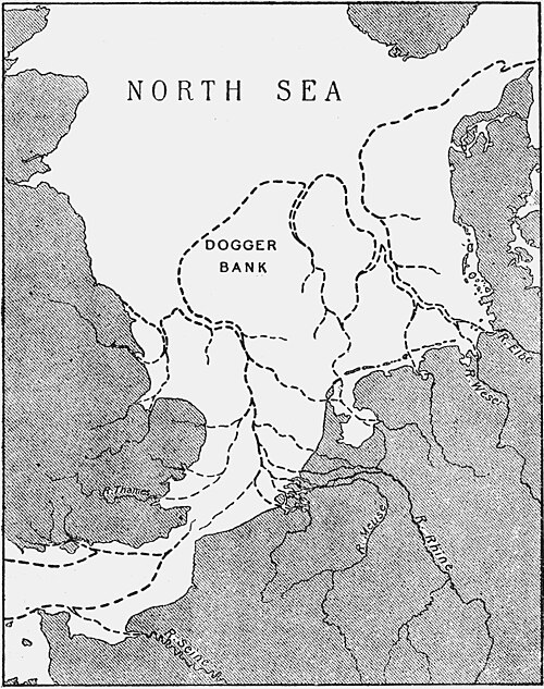
What the seismic showed was a landscape, not a slope. Meandering river channels: one of them, “the Southern River,” draining north and east out of what is now East Anglia toward a large estuarine basin near the Outer Dowsing Deep. Tunnel valleys cut by Pleistocene meltwater. Low ridges where Permian salt domes had risen through the overburden. Lakes. Salt marshes. A working country, written into the seabed.
The flora has now been reconstructed in unprecedented detail. In March 2026, Robin Allaby of the University of Warwick and colleagues published in Proceedings of the National Academy of Sciences a sedimentary-ancient-DNA (sedaDNA) analysis of 252 samples taken from 41 marine cores along the Southern River palaeo-channel (Allaby et al. 2026, PNAS, DOI 10.1073/pnas.2508402123). The DNA showed temperate woodland species, oak, elm, and hazel, present in southern Doggerland by around 16,000 years ago, several thousand years earlier than mainland British pollen records would suggest. Lime (Tilia) appears about 2,000 years earlier than its mainland British record. Allaby, in the Warwick press release of March 2026, said: “By analysing sedaDNA from Southern Doggerland at a scale not seen before, we have reconstructed the environment of this lost land from the end of the last Ice Age until the North Sea arrived. We unexpectedly found trees thousands of years earlier than anyone expected, and evidence that the North Sea fully formed later than previously thought” (University of Warwick press release, 2026).
The same cores yielded a more provocative, tentative signal: DNA putatively assigned to Pterocarya, a wingnut tree last recorded in north-western European pollen records around 400,000 years ago (Allaby et al. 2026). The team flags it as a finding that needs independent replication; sedaDNA can be reworked, and a single genus picked up in cores is not the same as a population. But if real, Pterocarya in Doggerland implies that pockets of the southern North Sea acted as glacial microrefugia for warmth-loving trees long after their supposed extirpation.
The Trawlers’ Museum: How Doggerland Was Discovered
The Colinda point did not start the science of Doggerland by itself. It made it unignorable. Trawlers working the southern North Sea in the late nineteenth and early twentieth centuries had been dredging up the bones of land mammals, mammoth molars, woolly rhinoceros teeth, aurochs horncores, the antlers of giant deer, for decades. The English geologist Clement Reid had collected and described them in his 1913 Submerged Forests. But bones could be argued away as carcasses dropped from icebergs or rafted out by rivers. An antler harpoon, manufactured, used, lost, could not.
After being examined and politely returned by the British Museum, the point was acquired by the Lowestoft surgeon and naturalist H. Muir Evans, who bequeathed it to Norwich Castle Museum (Norfolk Museums Service catalogue, NWHCM:1932.39). It was exhibited at the Prehistoric Society of East Anglia in February 1932 and announced the following year in E.M. Reid and Erdtman’s pollen analysis of the surrounding moorlog, which confirmed a freshwater, terrestrial environment at the find depth. Whoever had lost the harpoon had lost it on land.
After that, the trail went cold for the better part of seventy years. Luc Amkreutz, curator of prehistoric collections at the National Museum of Antiquities in Leiden, told Archaeology Magazine in 2022 that the point’s significance had always been understood but could not be acted on. “It’s an important object,” Amkreutz said, “because the idea became clear that not only was this a landscape that was not always sea, but that it must have been one inhabited by humans” (Amkreutz quoted in Urbanus, Archaeology Magazine, March/April 2022).
The impasse broke through a methodological pivot. At a Birmingham seminar on the Mesolithic in 2001, Fitch, then a graduate student, and Thomson, a basin geomorphologist, realised the same 3D seismic cubes oil-industry geologists used to image Rotliegend sands could be reinterpreted for the post-glacial sediment cover. By 2007 they had mapped this palaeolandscape across the southern North Sea (Gaffney, Thomson and Fitch 2007). The Lost Frontiers project, funded by Gaffney’s ERC Advanced Grant from 2015, extended the mapping and then married it to vibracoring, sedaDNA, and tsunami sedimentology in the field. The Geoscopy story of the 1700 Cascadia earthquake and orphan tsunami, where a tsunami without a felt earthquake on one continent was traced across the Pacific by sand layers and dead cedar stands on another, applies the same logic at a different scale: the geological record of a wave is recoverable centuries or millennia later if you know how to look at peat and mud.
How Doggerland Drowned: Sea-Level Rise Before the Storegga Wave
The story of Doggerland is sometimes told as if it ended in a single afternoon, smashed by a North Sea tsunami around 8,150 years ago. The geology says something more interesting and more relentless. The wave was the last act of a drowning that had been under way for ten millennia.
At the Last Glacial Maximum about 26,500 years ago, global sea level stood roughly 120 metres below modern, and the area we now call Doggerland was a permafrost-fringed lowland connected to mainland Britain on one side and to the mouths of the Rhine and Thames on the other. As the Laurentide and Eurasian ice sheets melted through the late Pleistocene, water came back to the oceans in lurches. Meltwater Pulse 1A, the largest of these, raised global mean sea level by 17.9 m (95% confidence interval 15.7–20.2 m) in 500 years around 14,650 years ago (Lin et al. 2021, Nature Communications, DOI 10.1038/s41467-021-21990-y). By the start of the Holocene, the North Sea was already eating into Doggerland from north and south. The Geoscopy story of the Messinian Salinity Crisis covers the opposite-sign analogue: a continental-scale change in base level driving a basin to dry, while Doggerland documents what happens when the basin fills.
A finer rhythm sits on top of that long curve. In 2019, Marc Hijma and Kim Cohen at Utrecht University compiled the Rhine–Meuse delta record into a single Holocene sea-level database and resolved two distinct sea-level jumps just before the 8.2 ka cold event (Hijma and Cohen 2019, Quaternary Science Reviews, DOI 10.1016/j.quascirev.2019.04.027). The first, dated 8.44 ± 0.41 ka, raised local relative sea level by 1.7 ± 0.6 m, about 2.5 ± 0.9 m once corrected for glacial isostatic adjustment to a global eustatic equivalent. A smaller second pulse of 0.2 ± 0.2 m followed at 8.22 ± 0.65 ka. Both are widely interpreted as the signature of the final drainage of Lake Agassiz–Ojibway in northern Canada, the same outburst that perturbed the Atlantic Meridional Overturning Circulation and triggered the 8.2 ka cold event (Barber et al. 1999, Nature; Hijma and Cohen 2019).
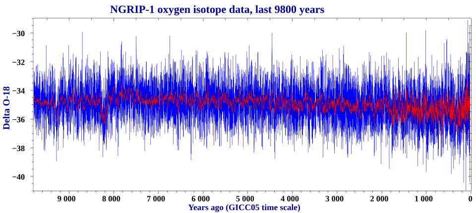
That cooling shows up in the Greenland NGRIP ice core as a δ¹⁸O excursion of more than 1‰, implying central Greenland surface cooling on the order of 3 °C, lasting about 160 years (Thomas et al. 2007). It would not have killed anyone on Doggerland by itself. But the sea-level jump that came with it removed a few more metres of shoreline at a stroke. By 8,300 years ago, what remained of Doggerland was an archipelago: a large Dogger Island over what is now the Dogger Bank, plus a scatter of smaller islands and shoals stretching south toward the Brown Bank and east toward Jutland (Walker et al. 2020, Antiquity, DOI 10.15184/aqy.2020.49). The British mainland and the continental shore were already separate countries.
The Storegga Slide
About 100 kilometres off the coast of Møre in western Norway, the continental slope drops from the shelf break down toward the Norwegian Sea over a span the Norwegians have always called Storegga, “the big edge.” The shelf there had been receiving glacial debris from the Fennoscandian ice sheet for tens of thousands of years, layer on layer of fine clay separating coarser glacigenic units. When the ice retreated in the early Holocene, the continental crust started to rebound. Bottom-water temperatures rose. Methane-bearing gas hydrates near the base of the hydrate stability zone began to lose their cap.
Sometime around 8,150 ± 30 calendar years before present, a section of that slope failed (Bondevik et al. 2012, Quaternary Science Reviews 45: 1–6, DOI 10.1016/j.quascirev.2012.04.020; Bondevik et al. 2003, Eos, DOI 10.1029/2003EO310001). It failed retrogressively, not as one block but as a cascade of perhaps seventy or more individual headwall failures racing back up the shelf. The classical reconstruction by Haflidason et al. (2005, Marine and Petroleum Geology, DOI 10.1016/j.marpetgeo.2004.10.008) put the total volume mobilised at 2,400–3,200 km³, with a run-out of about 800 km onto the Norwegian Basin floor, enough sediment, GEOMAR have noted, to bury all of Germany under seven to nine metres of mud (GEOMAR press release, 2023).
That volume estimate has tightened since. Jens Karstens of GEOMAR Kiel and co-workers, in Communications Earth & Environment (Karstens et al. 2023, DOI 10.1038/s43247-023-00710-y), reinterpreted high-resolution echosounder profiles and sediment cores from the northern slide scar and concluded that more than 35 m of section there belongs not to the 8.15 ka event but to a previously unrecognised slope failure, which they named the Nyegga Slide, at the end of the Last Glacial Maximum around 20,000 BP. Stripping that material out reduces the tsunamigenic 8.15 ka Storegga volume substantially, to the order of 1,300–2,300 km³. The paper carries an unsettling corollary: “large slope failures at the mid-Norwegian margin occur more frequently than previously thought, indicating a higher tsunami hazard for the North Atlantic” (Karstens et al. 2023). A smaller slide than the one geophysicists had been imagining produced the same wave. That wave needs less material to recur.
The trigger remains an active debate. Bryn et al. (2005, Marine and Petroleum Geology) emphasised the role of weak contouritic clay layers loaded by glacial sedimentation, with an earthquake from post-glacial isostatic rebound as the most likely seismic catalyst. Bünz, Mienert and others have pointed to gas-hydrate dissociation as a contributing destabiliser. Bondevik et al. (2024, Nature Communications, DOI 10.1038/s41467-024-47347-9), a separate paper from the volume question, added a wrinkle: many of the Nordic Sea sediment cores used to characterise the 8.2 ka cold event are contaminated by Storegga-tsunami reworking, which means parts of the climate record everyone had been reading were partly the slide’s own signature.
The Storegga Tsunami: Onshore Evidence and Run-up
Onshore evidence for the Storegga tsunami was first identified by Alastair Dawson, David Long and David Smith on the east coast of Scotland in the late 1980s: a single anomalous sand sheet in coastal peat (Dawson et al. 1988, Marine Geology). Through the 1990s and 2000s, Stein Bondevik and colleagues at the University of Bergen extended the record up the Norwegian coast, onto the Faroes, and into Shetland. The numbers they reported were, for the Holocene, extraordinary.
“Approximately 3500 km³ material slid out and generated a huge tsunami dated to about 7300 ¹⁴C yr BP, or ca 8150 calendar years BP,” they wrote. The paper then demonstrated that at Shetland, the tsunami reached onshore heights “at least 20 m above the sea level of that time.” (Bondevik et al. 2003, Eos, DOI 10.1029/2003EO310001). In their later synthesis (Bondevik et al. 2005, Marine and Petroleum Geology), they put outer-coast Norwegian run-up at 10–12 m, north-east Scottish run-up at 3–6 m, and Faroese run-up at around 10 m. Younger work has traced equivalent deposits into the inner Varangerfjord in Arctic Norway and onto the east coast of Greenland.
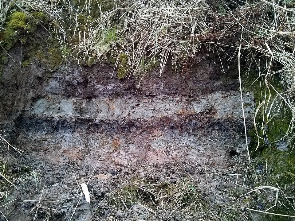
The Shetland deposits are the clearest. At Sullom Voe and Maggie Kettles Loch, a sharp-based grey sand sheet sits inside a peat sequence, capped and floored by woody organic mud. Where the tsunami was strong enough to entrain peat rip-up clasts, those clasts sit re-deposited at the top of the sand layer, evidence of more than one wave: the first eroding the marsh, the backwash and the second pulse re-depositing what had been picked up (Bondevik et al. 2003).
What had been missing for decades was evidence from the southern North Sea, the part of the basin where Doggerland’s last archipelago actually sat. Storm-deposited sand sheets in Holocene peat occur everywhere along the German, Dutch and English coasts and look annoyingly similar to tsunami beds. The southern North Sea is a shallow, wide shelf that should attenuate a tsunami arriving from the north. It was reasonable to suspect the wave had quietly died before it got there.
That suspicion broke in 2020. James Walker, Gaffney, Fitch and colleagues, working from the Europe’s Lost Frontiers vibracores, published a multi-proxy reconstruction of core ELF001A: a sediment column from a palaeo-river channel system in the Outer Dowsing Deep, off the Lincolnshire coast (Walker et al. 2020, Antiquity, DOI 10.15184/aqy.2020.49; Gaffney et al. 2020, Geosciences, DOI 10.3390/geosciences10070270). The core contained an erosively-based bed of clastic sediment, broken shells, stones and rip-up clasts dated by OSL and radiocarbon to within decades of 8.15 ka. It carried foraminifera mixed across normally-segregated assemblages and a sedaDNA signature dominated by oak and hazel mixed with marine indicators. It was, the authors argued, the first directly-cored Storegga tsunami deposit from the southern North Sea.
The framing was deliberately cautious. “Around 8150 BP, the Storegga tsunami struck North-west Europe,” the Walker paper opened. “The size of this wave has led many to assume that it had a devastating impact upon contemporaneous Mesolithic communities, including the final inundation of Doggerland… the authors present the first evidence of the tsunami from the southern North Sea, and suggest that traditional notions of a catastrophically destructive event may need rethinking” (Walker et al. 2020).
Four years later, Andreas Vött, Hanna Hadler and colleagues at the University of Mainz pushed the southern limit further still. Core Garding-2A, from the Eiderstedt Peninsula in North Frisia on the German Bight, produced a 5 m sequence with a sharp-based, fining-upward sand layer carrying rip-up clasts and a strongly-mixed foraminiferal assemblage at the right depth and date. “We identified a high-energy event layer with sedimentological (e.g., erosional unconformity, rip-up clasts, fining-upward), microfaunal (e.g., strongly mixed foraminiferal assemblage) and other features typical of tsunami influence and identical in age with the SST, dated to ca. 8.15 ka cal BP,” they wrote (Vött et al. 2024, Geosciences, DOI 10.3390/geosciences14100262). “SST candidate deposits identified at Garding represent the southernmost indications of this event in the southeastern North Sea.” A wide shallow shelf may damp a tsunami, but it does not stop it.
Was It the End of Doggerland?
For about twenty years after the Bondevik papers established the run-up heights, the standard narrative was straightforward and bleak. Bernhard Weninger of the University of Cologne and co-authors gave it its hardest form in Documenta Praehistorica in 2008: “Around 8200 calBP, large parts of the now submerged North Sea continental shelf (‘Doggerland’) were catastrophically flooded by the Storegga Slide tsunami, one of the largest tsunamis known for the Holocene” (Weninger et al. 2008, Documenta Praehistorica 35: 1–24). They modelled the inundation as the final blow that pushed already-vulnerable archipelago populations across the threshold into extinction, with knock-on cultural effects rippling into northern Germany and Jutland.
Walker, Gaffney and the Lost Frontiers team have spent the last several years dismantling that picture from the cores up. Their argument turns on three observations from ELF001A and the surrounding seismic.
First, the tsunami deposit at ELF001A is overlain by lacustrine and terrestrial sediments. The land came back. Whatever the wave did to that particular palaeo-channel, it did not drown the site. “SedaDNA evidence from the cores suggests a withdrawal of floodwaters and recovery of the land on the Dogger Littoral,” Walker and colleagues wrote. “Hence, the eventual inundation of the remaining parts of Doggerland resulted from the inexorable sea-level rise, rather than a great wave” (Walker et al. 2020).
Second, the topography mattered. By 8.15 ka, what was left of Doggerland was a fragmented archipelago, with the remnant Dogger Island acting as a partial barrier between the wave’s northern propagation and the southern flats. Numerical modelling by Jon Hill at Imperial College and colleagues, incorporating realistic palaeobathymetry, found wave heights “high enough to inundate Doggerland” (Hill et al. 2014, Ocean Modelling 83: 11–25, DOI 10.1016/j.ocemod.2014.08.007); follow-up work argued the resulting run-up across the surviving archipelago was destructive but bounded — on the order of a few metres rather than a wall of water (Hill et al. 2017, preprint arXiv:1707.05593).
Third, and most importantly for any account of Doggerland’s “end,” the new sedaDNA timescale from Allaby et al. (2026) implies that recognisable terrestrial ecosystems persisted in parts of southern Doggerland not just past the Storegga wave but for another millennium beyond, to perhaps 7,000 years ago. Allaby’s phrasing in the PNAS paper is precise: oak/elm/hazel woodland communities show DNA-recoverable presence well after 8.15 ka in some cores, with full marine inundation arriving in stages through the seventh millennium BP (Allaby et al. 2026).
This is not a vindication of the no-impact view. Vött’s Garding-2A core shows that the wave reached the German coast with enough energy to leave a rip-up bed several tens of kilometres inland of the contemporary shoreline. On parts of the Norwegian coast, lithic technologies before and after the event have been argued to show population disruption. What the new evidence does mean is that the wave was an episode within a much longer drowning, not the drowning itself. The killing force for Doggerland was eustatic sea-level rise of a few millimetres per year over thousands of years. The wave was punctuation.
Doggerland’s Buried Archive: What the North Sea Still Holds
The southern North Sea is one of the most heavily-trawled and dredged seas on Earth, and the spoil heaps it produces are an unintentional museum. Dutch beach replenishment programmes use sand dredged from offshore borrow pits, and walkers along the Zandmotor and the Maasvlakte regularly find Ice Age fauna among the shells: woolly mammoth molars, woolly rhinoceros teeth, bison and aurochs bone, cave-lion and wolf jawbones, the antlers of giant deer. The National Museum of Antiquities in Leiden curates one of the world’s largest collections of dredged Pleistocene fauna.
Then, in 2001, an aggregate dredger working the Zeeland Ridges, about 15 km off the Dutch coast, raised a fragment of human frontal bone alongside Middle Palaeolithic flint tools and faunal remains. In 2009, Jean-Jacques Hublin (then at the Max Planck Institute for Evolutionary Anthropology in Leipzig), Wil Roebroeks (Leiden University) and colleagues published the find in the Journal of Human Evolution (Hublin et al. 2009, J. Hum. Evol. 57: 777–785). The supraorbital morphology and 3D geometric-morphometric assessment of the bone “unambiguously assign the Zeeland Ridges frontal bone to Homo neanderthalensis,” the paper reported, with morphometric affinities to Late Pleistocene Neanderthals such as those of La Chapelle-aux-Saints and La Ferrassie 1 (Hublin et al. 2009); the Leiden University press release accompanying the publication gave an indicative age of roughly 60,000–70,000 years. The bone shows a lesion that Hublin and colleagues interpreted as an intradiploic epidermoid cyst, the first such pathology diagnosed in Neanderthal remains. He was a young adult male, sick, and a long way from any modern shoreline.
Mesolithic finds from the post-glacial Doggerland surface are now numerous enough to fill a museum on their own. Barbed antler points like the Colinda piece. Aurochs jawbones with cut marks. A 13,000-year-old aurochs bone from the Brown Bank engraved with a zigzag pattern that may be the oldest figurative art yet recovered from the southern North Sea (collections of the Rijksmuseum van Oudheden, Leiden). Mesolithic stone tools, including a chert hammerstone dredged near the Southern River estuary site, are recovered with regularity by trawlers working between Lowestoft and Den Helder.
The future of the field is more cores and more DNA. The Europe’s Lost Frontiers programme finished its primary coring phase in 2021; the Submerged Landscapes Research Centre at the University of Bradford continues to integrate seismic, sedimentology, palaeobotany and sedaDNA across the basin. The Vött group at Mainz has signalled that further Storegga candidate deposits along the German Bight are now under investigation. The 1932 Norwich accession card for the Colinda point still reads, in pencil, “from peat, Leman & Ower Bank.” Nine decades later, the rest of the country it came from is finally being put back together.
Doggerland and Modern Sea-Level Rise: Why It Matters Now
Doggerland is the closest analogue the geological record offers to the inundation of populated low-lying land by post-glacial sea-level rise. It is not a perfect analogue. The long-run average rates that drowned it, typically a few millimetres per year, peaking briefly above 40 mm/year during meltwater pulses, are smaller than the high-end transient rates projected for the late twenty-first century under the IPCC’s very-high-emission scenario (likely global mean sea-level rise of 0.63–1.01 m by 2100 relative to 1995–2014 under SSP5-8.5; Fox-Kemper et al. 2021, IPCC AR6 WGI Chapter 9, Table 9.9). The coast that drowned was not engineered. The communities living on it had no levees and no insurance.
What Doggerland does show is what the geological record looks like when a slow, multi-millennial drowning is punctuated by sudden events, meltwater pulses, deglaciation-driven landslides, the wave that the Storegga generated. The Bondevik and Walker work makes a specific point that travels: tsunamis on wide, shallow continental shelves are not erased by bathymetry. The Vött 2024 paper makes it twice: the German Bight, long held to be too shallow and too far from Storegga to register, did register. The hazard frame for the modern North Atlantic, for the Faroes, Shetland, Norway and Scotland, needs the Karstens 2023 finding that the mid-Norwegian margin has failed more often than people thought.
There is a quieter implication too. The Allaby 2026 sedaDNA work shows that ecosystems we believed had been wiped out 16,000 or even 400,000 years ago survived in pockets of marginal terrain that no one was looking at. That has implications for how we read modern refugia: patches of habitat that look unpromising but may carry persistence value across glacial cycles.
In 2023 a Dutch dredger working off the Brown Bank brought up a chunk of moorlog about the size of a kitchen table. A vibracore taken from a similar piece by the Europe’s Lost Frontiers team a few years earlier had dated to around 8,600 cal BP, older than the Storegga wave, older than the catastrophic narrative the wave used to anchor. The peat, hauled out into the air, was still soft enough to take the print of a thumb. Somewhere beneath it, in a layer everyone is now learning to read more carefully, is the bed of a country that has been drowning, in pieces, since before anyone wrote anything down.
Frequently Asked Questions
When did Doggerland sink?
Doggerland drowned in stages over thousands of years, not in a single event. The Last Glacial Maximum lowstand of roughly 120 m below modern sea level rose through the late Pleistocene and early Holocene, fragmenting the landmass into an archipelago by around 8,300 years ago. The Storegga tsunami struck what remained at 8,150 cal BP. SedaDNA evidence published in 2026 shows that parts of southern Doggerland remained above water until around 7,000 years ago.
Did the Storegga tsunami destroy Doggerland?
No. The Storegga tsunami, generated by a submarine landslide off the Norwegian coast at about 8,150 cal BP, was a major event with run-up heights reaching 20 m on Shetland and over 10 m on the Norwegian coast. But Doggerland was already an archipelago by then, drowning under millennia-long eustatic sea-level rise. Sediment cores from the southern North Sea show that affected land surfaces recovered after the wave. The final inundation was caused by continued sea-level rise over the following thousand years, not by the tsunami itself.
What artefacts have been found from Doggerland?
The most famous Doggerland artefact is the Colinda harpoon, a Maglemosian antler point dredged off the Norfolk coast in 1931. Since then, trawlers and aggregate dredgers have recovered Mesolithic stone tools, barbed antler points, an aurochs bone engraved with a zigzag pattern (sometimes called the oldest Dutch artwork), Pleistocene mammoth and woolly rhinoceros remains, and a Neanderthal frontal bone from the Zeeland Ridges off the Dutch coast. The National Museum of Antiquities in Leiden curates one of the world’s most important Doggerland collections.