Introduction
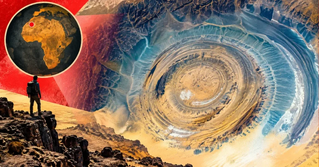
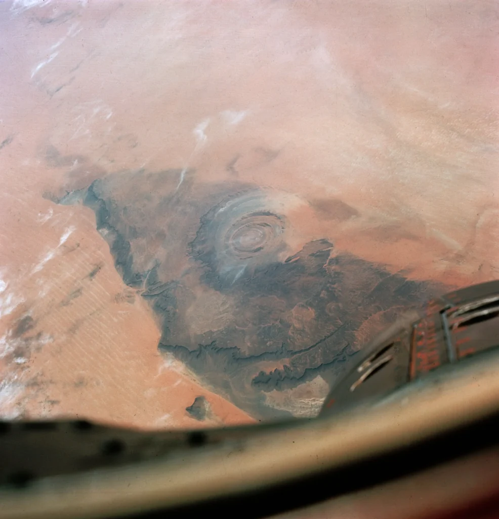
On June 4, 1965, James McDivitt and Ed White were less than a day into Gemini IV, the flight on which White became the first American to walk in space. NASA had asked the crew to photograph the terrain below, and possible scars of ancient impacts were among the features of interest. Somewhere over the western Sahara, one of them aimed a Hasselblad out the window and pressed the shutter. The frame, catalogued as GEM04-16-34670, captured a near-perfect bullseye of stone rising out of an ocean of sand: rings within rings, dozens of kilometers across, staring back at the spacecraft like a vast unblinking eye.
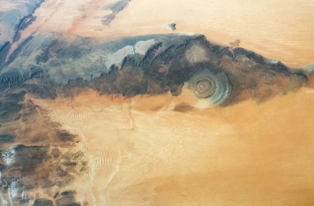
That photograph turned a little-known patch of Mauritanian desert into one of the most recognizable landforms on the planet. We call it the Eye of the Sahara now, or the Eye of Africa. Geologists call it the Richat Structure. And for decades, almost everyone, including the scientists, got its origin story wrong.
What it is, and where
The Richat Structure sits on the Adrar Plateau near the oasis town of Ouadane, in the Adrar Region of northern Mauritania, at roughly 21°N, 11.5°W. It marks the northwestern edge of the Taoudeni Basin, a great slab of ancient sedimentary rock that underlies much of West Africa. NASA’s Earth Observatory pegs the bullseye at 40 kilometers (25 miles) wide, and the team that resolved its origin, Matton, Jébrak and Lee, described it as a dome “at least 40 km in diameter.” It is big enough that, from ground level, you would never guess you were standing inside a circle at all. You’d see only ridges, valleys, and sand.
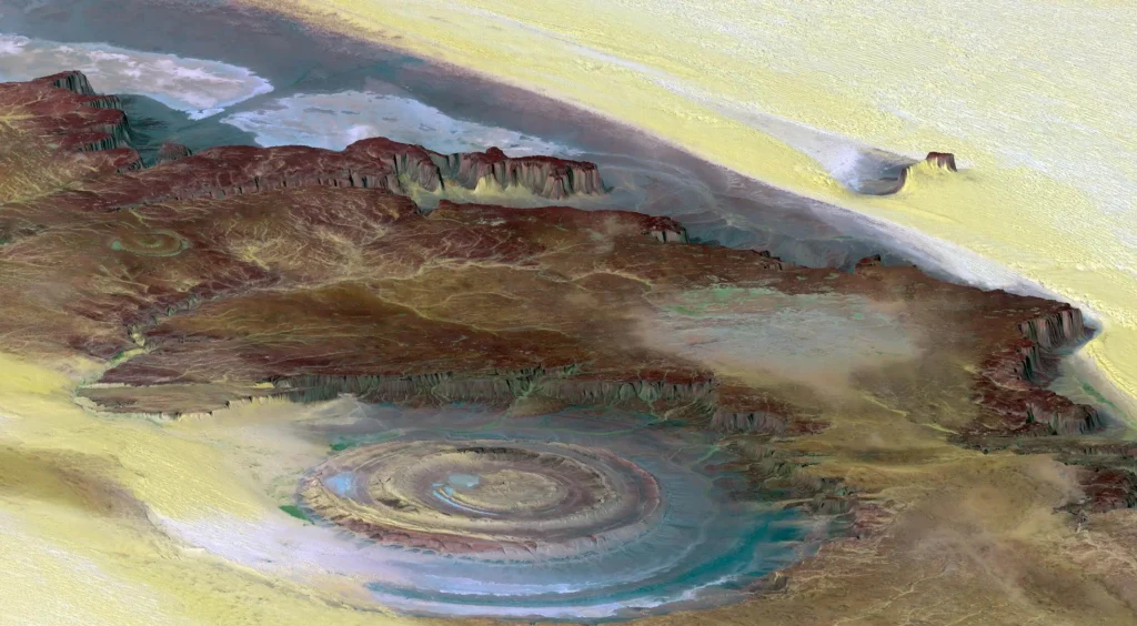
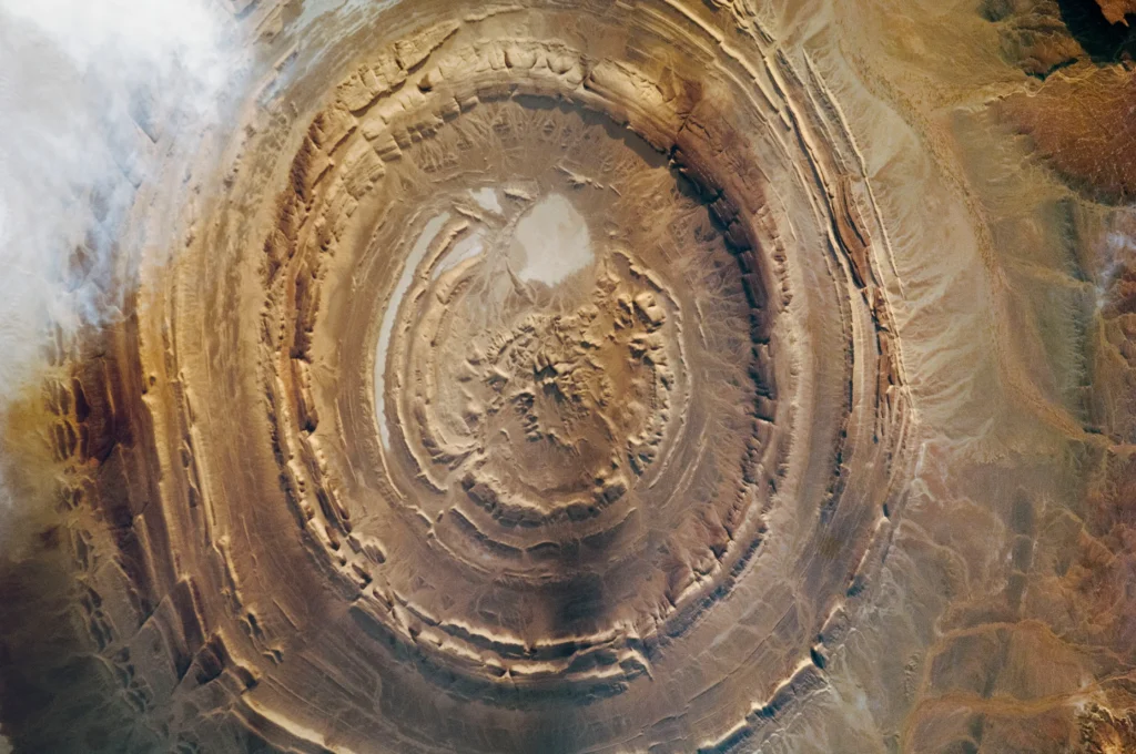
From orbit the geometry snaps into focus. Concentric rings of rock, made of strata ranging from Late Proterozoic to Ordovician in age, dip gently outward from the center at 10 to 20 degrees. Resistant bands of quartzite stand up as steep-sided ridges, geologists call them cuestas, while softer layers between them have been scooped out into circular valleys. The oldest rocks are exposed at the very middle, the youngest around the rim, exactly the pattern you’d expect from an eroded dome sliced flat across its top.
The result is a feature so symmetrical it looks engineered. It isn’t. It is the work of deep heat, slow uplift, and a hundred million years of wind and water.
From “buttonhole” to bullseye
French geographers working in colonial Mauritania first put the structure on the map in the 1930s and 1940s, describing it as the Richât crater or, more evocatively, the boutonnière du Richât, the Richat buttonhole, a slit in the fabric of the desert. In 1948 the French geographer Jacques Richard-Molard proposed that it had been pushed up from below, the result of a laccolithic uplift, molten rock intruding and doming the layers above it.
Then came a complication. In 1952, an expedition led by the naturalist Théodore Monod catalogued four “crateriform” features in the Mauritanian desert. Three of them, Aouelloul, Temimichat-Ghallaman, and Tenoumer, really are impact craters, gouged by meteorites. The Richat sat in the same neighborhood and shared the same suspicious circularity. Guilt by association set in, and the impact idea took hold.
Gemini IV poured fuel on it. When the world saw that bullseye from space in 1965, an impact scar seemed the obvious explanation. Big rocks from the sky make big circles. What else could it be?
The impact theory falls apart
The case for an impact rested heavily on one mineral. In 1964, the French geologist André Cailleux and colleagues reported finding coesite in rock samples from the Richat. Coesite is a high-pressure form of silica that, on Earth’s surface, forms almost exclusively under the ferocious shock of a hypervelocity impact. Its presence would have been a smoking gun.
In 1969, the American geologist Robert Fudali tested that claim and demolished it. Writing in Science, he reported that the “shattered sandstone” said to contain coesite was actually a tectonic breccia, a crushed zone formed during the structural doming, and that the supposed coesite was nothing of the kind. An optical and X-ray examination showed the mineral was barite, a common, harmless sulfate carried into the crushed rock by groundwater. The X-ray reflections attributed to coesite, he found, belonged to barite all along.
That same year, Robert Dietz, Fudali, and William Cassidy published a paper whose title said the rest out loud: “Richat and Semsiyat Domes (Mauritania): Not Astroblemes.” Field surveys turned up none of the diagnostic signatures of an impact, no shocked quartz, no melt rock, no shatter cones. The Eye of the Sahara had never been hit by anything.
How the Eye of the Sahara actually formed
The modern picture, assembled over decades and crystallized in a landmark 2005 paper by Guillaume Matton, Michel Jébrak, and James Lee in the journal Geology, is more interesting than any impact. The Richat is a deeply eroded geologic dome, a domed anticline, that formed when molten rock pushed up from beneath, lifting and arching the sedimentary layers above it like a blister.
The plumbing beneath is a textbook alkaline igneous complex. Matton and Jébrak’s later work describes it as a bimodal tholeiitic suite, rhyolitic volcanic centers and gabbroic rock, crosscut by swarms of carbonatite (a rare, carbonate-rich igneous rock) and kimberlite, the same kind of rock that elsewhere carries diamonds. According to field, aeromagnetic and gravimetric mapping, the gabbro forms two concentric ring dikes: an inner ring about 20 meters wide roughly 3 kilometers from the center, and an outer ring about 50 meters wide some 7 to 8 kilometers out. Swarms of carbonatite dikes and sills, generally around 300 meters long and 2 to 4 meters wide, have been mapped within the structure, alongside rhyolitic eruptive centers interpreted as the eroded roots of two maar volcanoes.
The Eye of the Sahara is not a wound. It is a window, erosion’s cross-section through the guts of a dead volcano.
At the very center sits one of the structure’s strangest features: a kilometer-scale siliceous megabreccia, a jumble of shattered, silica-cemented rock fragments. Matton and his colleagues argued this wasn’t blasted into place but dissolved and collapsed, the product of hot, mineral-rich fluids carving out cavities deep underground, a kind of hydrothermal karst, until the roof gave way. Once the dome stopped rising, wind and water went to work, stripping away the softer rock faster than the hard quartzite and igneous ridges. Differential erosion did the rest, etching the rings we see from orbit.
How old is the Eye of the Sahara?
Dating the Richat has been a long, messy job, and the numbers reward a careful reading. Apatite fission-track work in the 1990s on the carbonatite dikes returned ages of 99 ± 5 million years and 85 ± 5 million years, squarely in the mid-Cretaceous. The central hydrothermal breccia was dated to 98.2 ± 2.6 million years by the argon-argon (⁴⁰Ar/³⁹Ar) method in the 2005 study. A kimberlite plug came in around 99 million years. That cluster around 100 million years ago places the alkaline magmatism and the doming firmly in the Cretaceous.
Then the story got a second chapter. In 2024, El Houssein Abdeina and colleagues, writing in Lithos, reported the first argon-argon ages on plagioclase from the Richat’s gabbros. Here the authors are admirably blunt: no robust age was obtained. Instead, numerical modelling of their data suggests the gabbros were intruded between 230 and 200 million years ago. That 230–200 Ma figure is a modelled bracket, not a precise measured age, a distinction worth keeping straight.
Why does it matter? Because that bracket overlaps the Central Atlantic Magmatic Province, or CAMP, a colossal pulse of volcanism whose peak phase has been dated by U-Pb zircon geochronology to about 201.5 Ma (Blackburn et al., Science, 2013), erupting as Pangaea began to tear apart and the Atlantic Ocean started to open. The Abdeina team argues the Richat’s gabbros are two CAMP sills, injected into the Taoudeni Basin’s strata around 200 million years ago, and that roughly 100 million years later a separate alkaline intrusion, the carbonatites, domed everything up into the circle we see today. In their words, the Richat records a two-stage igneous history separated by about 100 million years. The eye, in other words, has two birthdays.
In October 2022 the International Union of Geological Sciences put the Richat on its inaugural list of the world’s first 100 geological heritage sites, calling it “a spectacular example of a magmatic concentric alkaline complex.”
And no, it isn’t Atlantis
It was probably inevitable. A giant set of concentric rings in the desert, and Plato’s Atlantis, described in the dialogues Timaeus and Critias around 360 BC as a city of alternating rings of land and water, were always going to find each other on the internet. The claim, popularized in viral videos, runs roughly: the rings match, the scale fits a great metropolis, and a once-green Sahara could have hidden a drowned civilization.
It’s a fun idea, and it falls apart the moment you look at the rock.
Start with the rock itself. The Richat is a natural igneous and sedimentary dome whose magmatism dates to the Cretaceous and whose deeper sills may reach back 200 million years. It predates not just any human city but the entire human lineage by tens of millions of years. There is nothing to build on top of a structure that built itself.
Then there’s the archaeology, or its absence. As the archaeologist Sean Rafferty has noted, beyond the superficial fact of being circular, the Richat bears little resemblance to Plato’s Atlantis, and its location far inland in a desert flatly contradicts the account. The skeptic Steven Novella has pressed the same point: there is no evidence of a built city, no temples, no ring-shaped canals, none of the engineering Plato describes. Stone tools and rock art attest that ancient humans passed through the region, but a hand axe is not a harbor.
Finally, the geography is simply wrong. Plato placed Atlantis on an island “larger than Libya and Asia combined,” beyond the Pillars of Hercules, the Strait of Gibraltar, that sank beneath the sea in a single day and night. The Richat is a 40-kilometer dome, not a continent; it sits about 500 kilometers (300 miles) inland from Mauritania’s Atlantic coast, not as an island in the ocean; and it never sank. Most classicists, for their part, read Atlantis as exactly what its structure suggests: a philosophical fable about hubris, invented by Plato to make a point, not a place to be found on a map.
The Eye of the Sahara isn’t a lost city. It’s a slice through the machinery of a planet, the fossilized plumbing of an ancient volcanic system, hauled to the surface and laid bare by erosion, sitting in plain sight for any astronaut to see.
The bottom line
For all the mythology that has accreted around it, the Eye of the Sahara is a triumph of ordinary geology made extraordinary by scale and circumstance. Heat lifted it, fluids hollowed it, and the relentless erosion of a desert that has no trees to soften the view exposed its anatomy in perfect, concentric clarity. The astronauts who first saw it were right to stare. They were just wrong about why.
Frequently asked questions
Is the Eye of the Sahara an impact crater? No. Early reports of coesite, a shock-formed mineral, were shown in 1969 to be a misidentification of barite, and field surveys have never found shocked quartz, melt rock, or shatter cones. It is a deeply eroded geologic dome above an alkaline igneous complex.
How old is the Eye of the Sahara? The alkaline magmatism and doming cluster around 100 million years ago (mid-Cretaceous). A 2024 study suggests the deeper gabbro sills may date to roughly 200 million years ago, tied to the Central Atlantic Magmatic Province, giving the structure a two-stage history.
Is the Eye of the Sahara Atlantis? No. The structure is tens of millions of years older than the human lineage, shows no trace of a built city, and sits about 500 kilometers inland rather than as an island in the ocean. The match to Plato’s account is superficial.
How big is the Eye of the Sahara? About 40 kilometers (25 miles) across.