Most geology runs at speeds you can’t perceive in a lifetime. Rivers are the exception. Watch one long enough and you can see how rivers shape the land in real time: banks slumping, gravel bars shifting, channels jumping their banks during a flood. We treat rivers as scenery, as plumbing, as boundaries on maps. They are machines for taking continents apart and reassembling them somewhere else, and they have been running on every landmass since there was rain. This is a guide to how they cut canyons, build deltas, abandon meanders, and respond when we get in their way.
How Rivers Erode, Transport, and Deposit Sediment
Geologists describe what rivers do in three words: erosion, transport, and deposition. These are not separate phenomena, and they are playing out continuously, everywhere there is moving water and a slope.
The Four Mechanisms of River Erosion
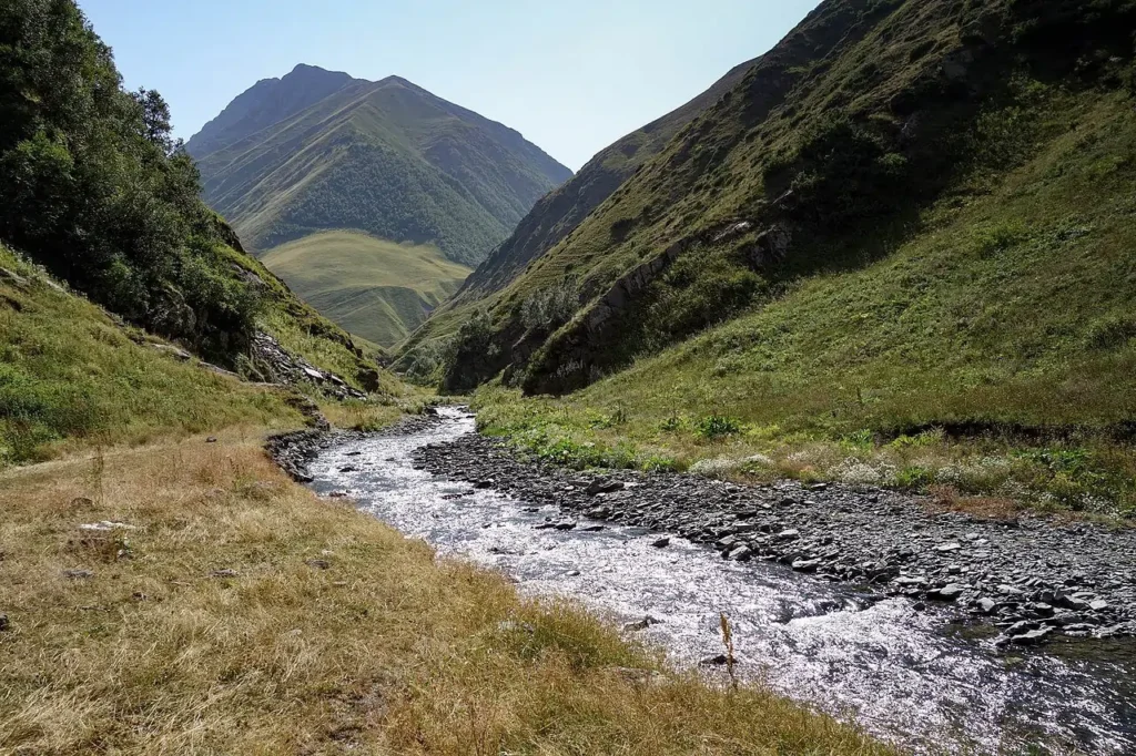
Rivers cut their channels through four mechanisms acting at the same time. Standing in a steep alpine torrent during snowmelt, you can feel three of them at once.
The most obvious is hydraulic action: the brute force of moving water. Fast flow over a jointed bed creates rapid pressure changes that pry water and air into fractures, loosening blocks and ripping fragments away. During floods this can dismantle bedrock in hours.
Mixed in with that water is the river’s load: sand, pebbles, boulders. They turn the river into sandpaper. Cobbles tumbling along the bed grind against bedrock: this is abrasion, the dominant cutting mechanism in steep upper reaches with a coarse load. The same particles also grind against each other, fracturing and rounding off as they travel. Geologists call that attrition, and it is why mountain rivers carry angular cobbles while lowland rivers carry rounded gravel. By the time a quartz grain reaches the sea it may have travelled thousands of kilometres, been buried, re-eroded, and recycled through more than one sedimentary cycle.
The fourth mechanism is invisible. Rainwater absorbs CO₂ from the atmosphere and from soil, becoming weak carbonic acid. Wherever that acid meets limestone, dolomite, or gypsum, it dissolves the rock along joints and bedding planes. This is solution (or corrosion), and it is the engine behind every karst landscape; the cave systems of Slovenia, the Yucatán, the Dinaric Alps. A young alpine torrent is mostly hydraulic action and abrasion. A slow river through chalk country is mostly solution. Most rivers are doing all four at once.
These four mechanisms operate everywhere, but their relative importance shifts with rock type, gradient, climate and sediment supply. A young alpine torrent is mostly hydraulic action and abrasion; a slow river through chalk country is mostly solution.
How Rivers Transport Sediment
Once material is detached, the river moves it four ways at once.
The smallest fraction is invisible: dissolved minerals carried as ions. The Mississippi alone delivers millions of tonnes of dissolved calcium and silica to the Gulf of Mexico every year. Slightly larger particles, fine clay and silt, ride in suspension, held up by turbulence. This is what makes the Yellow River yellow and the Rhine grey-green. Sand grains too heavy to suspend hop along the bed in short ballistic jumps called saltation. The largest particles, gravel, cobbles, boulders, roll along the bed by traction, often only during floods.
Two terms govern what a river can move. Competence is the size of the largest particle a river can shift. Capacity is the total mass it can carry. Both rise sharply with velocity, and not in a flattering way for anyone living downstream: a commonly taught rule of thumb says the largest particle a stream can move scales roughly with the sixth power of flow velocity. Total capacity also depends on discharge, turbulence, grain size, sediment supply, and channel shape. This is why a quiet stream becomes a boulder-throwing monster after a thunderstorm, and why most of the geomorphic work in any river is done not on average days but during the rare, violent flood.
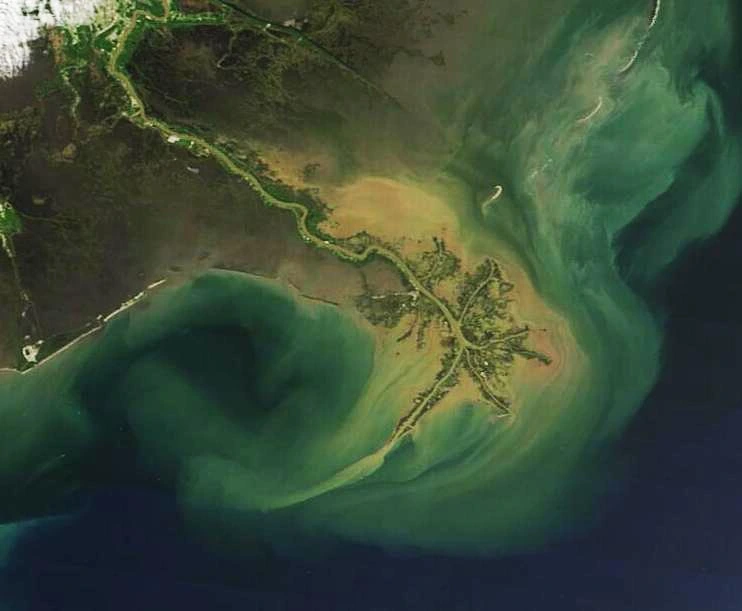
Where Rivers Build New Land: Floodplains, Fans, and Deltas
When a river loses energy, gradient flattens, the channel widens, the flow slows, it can no longer carry its load and starts dropping it. That is how floodplains, alluvial fans, point bars and deltas are built. The Po Valley, the Indus floodplain, almost every Swiss alluvial cone: all built this way.
Why Rivers Meander, Braid, or Run Straight
Rivers come in four basic patterns: straight, meandering, braided, and anastomosing. Two American geomorphologists, Luna Leopold and M. Gordon Wolman, showed in a now-classic 1957 paper for the U.S. Geological Survey that channel pattern is governed primarily by slope and discharge. At a given discharge, low-slope rivers meander; steeper rivers, especially those overloaded with coarse sediment, braid.
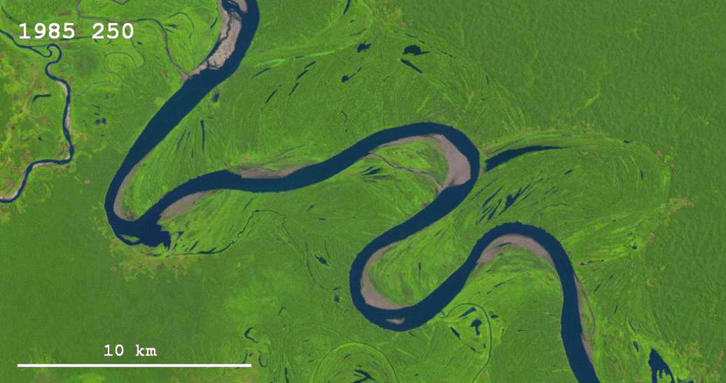
Meandering rivers are the iconic snaking pattern of lowland systems, the Mississippi, the Amazon, the Po. Sinuosity (channel length divided by valley length) above 1.5 is the textbook threshold. Meanders aren’t decorative. They’re the geometry rivers settle into when they have plenty of suspended fine sediment, gentle slopes and cohesive banks. Once a river starts to bend, hydrodynamics take over: water on the outside of a curve moves faster, scouring the bank, the cut bank. On the inside, flow slows and sediment drops, building a point bar. The bend grows tighter and migrates downstream.
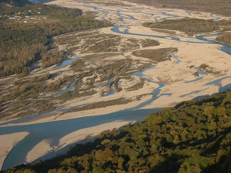
Braided rivers are wide, shallow systems split into countless threads weaving around gravel bars. They form where sediment supply outpaces transport capacity, typically in mountainous terrain, glacier-fed valleys and just-flooded outwash plains. The Tagliamento, in northeast Italy, is the clearest large braided river left in Europe. Its 150-square-kilometre active corridor is a constantly reshuffling mosaic of gravel islands; a single major flood can rework more than 60% of its channel pattern in a few days. Iceland’s Þjórsá and Markarfljót, born from glacier melt across volcanic ash plains, paint similarly dramatic silver-blue networks across black sand.
Anastomosing rivers are multi-thread but stable, separated by vegetated islands rather than bare gravel bars. The lower Magdalena in Colombia and parts of the upper Columbia in British Columbia are textbook examples. Straight rivers are rare in nature, almost any reach longer than a few channel widths picks up a curve.
How Meanders and Oxbow Lakes Form
Each bend grows wider, then tighter, until two adjacent loops touch and the neck between them collapses. The river abandons the loop, takes the shortcut, and leaves behind a curved scar of standing water: an oxbow lake.
The Ucayali River in Peru abandons meanders so frequently that satellite time-lapses from the 1980s to today look like the river is pacing across its floodplain. North America’s largest oxbow lake, Lake Chicot in Arkansas, was once part of the Mississippi; it was cut off about 600 years ago. Australia’s billabongs and South Texas’s resacas are oxbow lakes by another name.
The regularity of meanders is strictly mathematical. Leopold and Wolman noticed that across rivers of wildly different sizes, the wavelength of meanders is roughly 7 to 11 times the channel width, and the radius of curvature about 2 to 3 times the width. This scale invariance is one of the most reliable patterns in geomorphology, and one of the reasons rivers seen from a plane look strangely similar whether you are flying over Siberia, the Pantanal or Alaska.
Modern work using high-resolution satellite imagery shows that bends do not migrate at their sharpest point. There is a small downstream lag, and that lag is what makes bends slide sideways and downstream simultaneously, producing the elongated, comma-shaped scroll bars visible on every meandering floodplain.
The Stream Power Law: How Erosion Scales With Slope and Discharge
The single most useful equation in fluvial geomorphology is the stream power law:
E = K · Am · Sn
Where E is erosion rate, A is upstream drainage area (a proxy for discharge), S is local channel slope, and K, m, n are empirical constants depending on rock type and climate.
What this says is, erosion goes up faster when there is more water and more slope. It helps explain why reaches with the right combination of drainage area, slope, rock erodibility and climate can incise rapidly, especially in uplifting landscapes where rivers are forced to cut down faster than their profiles can smooth out.
A related rule, Hack’s law (John Hack, USGS, 1957), connects basin area to main-channel length: L ∝ Ah, with h consistently around 0.5 to 0.6. This is a strikingly stable relationship across basins. It works for Appalachian streams, Andean rivers, and even for unchannelised hillslopes in laboratory experiments.
What Is a Knickpoint? How Rivers Record Uplift
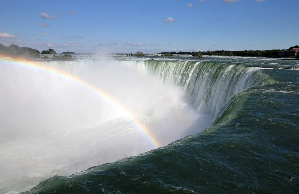
A knickpoint is a sharp break in a river’s longitudinal profile, a waterfall, a steep rapid, a gorge entrance. Knickpoints record disturbances. When the land beneath a river rises, or when sea level falls, the river suddenly has more potential energy to spend, and it spends it by cutting downward. The downcutting starts at the bottom of the system and propagates upstream, leaving a knickpoint like a wave travelling backward through the network.
Niagara Falls are classic examples. About 12,000 years ago, when the Laurentide Ice Sheet retreated from the Niagara Escarpment, a fresh 50-metre cliff stood in the river’s path. Since then it has eaten its way roughly 11 kilometres upstream. The historical retreat rate was around 1 metre per year; today, with most of the flow diverted for hydropower, it has slowed to roughly 0.03 to 0.3 m/yr depending on the section, perhaps a tenth of its natural rate.
Knickpoint propagation is among the clearest tectonic signals visible in the landscape. Recent work in the southeastern Tibetan Plateau shows that the Late Miocene incision of the Yangtze gorges, 1 to 2 kilometres of downcutting, was driven not by uplift alone but by drainage capture, where one growing river beheaded another and inherited its discharge. Similar transient incision waves are still propagating up the São Francisco River in northeastern Brazil and through the active subduction-zone islands of the Solomons.
When you see a waterfall, you are usually looking at a record of regional uplift, a base-level fall, or a piece of harder rock the river has not yet eroded through.
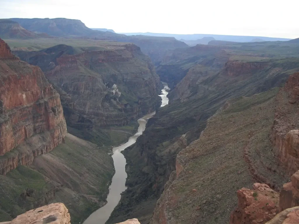
The Grand Canyon’s Missing Five Million Years
The Grand Canyon is the most famous fluvial landform on Earth, and until very recently it was also one of the least understood. The rocks at its rim are almost 300 million years old. The canyon itself is much younger, but exactly how young, and how it formed, has been argued for over a century.
Twelve different hypotheses have been proposed in the geological literature. The Colorado River clearly existed in western Colorado around 11 million years ago, but it did not exit the Grand Canyon area until roughly 5 to 6 million years ago. What was happening in between?
In April 2026, John J. Y. He (lead author), Ryan Crow of the U.S. Geological Survey, John Douglass (Paradise Valley Community College) and colleagues from the USGS, Arizona Geological Survey and UCLA published a Science paper that strongly strengthens one side of the debate. They analysed thousands of detrital zircon crystals, tiny minerals that act simultaneously as sedimentary fingerprints and U-Pb radiometric clocks, from the Bidahochi Basin in northern Arizona. Their results were striking: starting around 6.6 million years ago, the basin’s lake sediments show the unmistakable mineral signature of the upper Colorado River system. The proto-Colorado had reached the basin and filled it like a bathtub. When the lake overtopped the Kaibab Arch, the spilling water carved its way west and began incising the canyon. The work hasn’t ended the debate. Rebecca Flowers (University of Colorado Boulder) and others in the older-paleocanyon school have pushed back, arguing that notches in the Kaibab uplift would have let water escape the Bidahochi basin without rising as high as He et al. propose, and that an ancestral canyon may already have existed before the Colorado arrived. Flowers’s group has signalled a forthcoming paper presenting new mineralogical evidence connecting Bidahochi sands to the canyon by 4.8 million years ago.
This “lake spillover” mechanism had been argued for decades. The new zircon data provide direct provenance evidence that upper Colorado River sediment had reached the Bidahochi Basin by 6.6 million years ago. The spillover itself remains an interpretation, but it is now much better supported than before.
What the Tagliamento Teaches Us About Alpine Rivers
The Alps are one of the best places on Earth to watch fluvial processes in action, because the rivers are young, steep and, in places, only lightly engineered. The Tagliamento, draining roughly 2,900 square kilometres from the southern Alps to the Adriatic, is one of Europe’s clearest remaining examples of a large, morphologically dynamic alpine river. In dry seasons, long reaches of its broad gravel corridor split into shallow braids, exposed bars and vegetated islands; during major floods, those separate threads can merge into a single sediment-charged torrent. During snowmelt or autumn storms, the entire braidplain disappears under a single brown torrent.
Sedimentologists working in Switzerland use the modern Tagliamento as a process analogue for interpreting Pleistocene gravel deposits across the Swiss Mittelland. The same buried gravels that the Tagliamento helps us understand today host much of Switzerland’s drinking water. Modern braided rivers, preserved in rock, sit metres beneath the central plateau.
Switzerland’s own alpine rivers, the Aare, Rhône, Reuss and upper Rhine, have largely been straightened. Where they were once braided, they now flow in single deepened channels. The geomorphic consequences are real and ongoing: the Rhône’s gravel bedload has collapsed, its delta into Lake Geneva has retreated, and large-scale river restoration projects (the Thurkorrektion, the Aare-Hagneck restoration) are now reintroducing space for the river to wander, partly as flood protection and partly as habitat recovery. The Swiss Mittelland’s modern landforms were carved by repeated glacial cycles and their meltwater rivers over the past million years, sitting on top of a much older Molasse sedimentary basin. To understand Switzerland’s geology is to understand how its rivers built it.
The Anthropocene River: Dams, Sediment, and Sinking Deltas
Humans are now the most powerful geological agent acting on rivers. In roughly two centuries we have re-plumbed the global sediment cycle.
The foundational work here is by James Syvitski and colleagues, in two papers (Science, 2005; Philosophical Transactions of the Royal Society, 2011) that quantified what we had done. Pre-human global rivers carried about 12 to 14 billion tonnes of sediment to the oceans every year. Land clearing, agriculture, deforestation, road-building, mining, pushed soil erosion up by roughly 2.3 billion tonnes per year. But the proliferation of dams since the 1950s now traps about 1.4 billion tonnes per year upstream of where it would naturally reach the coast. The two effects partially cancel along the way, but at the river mouths, where it matters, sediment delivery is collapsing. Globally, around 49% of pre-dam sediment now reaches the sea, and more than 70% of major deltas have lost over half of their natural sediment supply.
The Three Gorges Dam, which began impounding the Yangtze in 2003 and was structurally completed in 2006, illustrates the scale. Sediment loads at Yichang, just downstream of the dam, have dropped by 97%. At the Yangtze delta apex 1,200 kilometres further downstream, the reduction is still 75%. The Yangtze delivered around 510 million tonnes of sediment per year to the East China Sea in the 1960s. Today it delivers under 140 million tonnes, roughly the same amount it was carrying 2,000 years ago, before agriculture had ramped erosion upward.
The Mississippi tells a similar story. Sediment load fell roughly 3.5 times between the early and late 20th century, primarily because of dams on the Missouri and Arkansas tributaries and the closing of the floodplain by levees. Coastal Louisiana has lost about 5,000 square kilometres of wetlands since the 1930s, partly because the river that built that land is no longer feeding it.
This matters because deltas are quietly sinking. Subsidence is natural: fresh delta sediments compact under their own weight at rates of several millimetres per year. Pre-dam, that subsidence was offset by new sediment arriving with each flood season. With sediment shut off, subsidence wins, and accelerating sea-level rise wins faster. The Nile, Mekong, Ganges-Brahmaputra, Mississippi and Niger deltas are all losing land to the sea on the scale of square kilometres per year.
About 5% of humanity lives on a delta.
Why This Matters: Rivers Are the Most Responsive Landform We Have
Rivers make one of geology’s deepest truths visible: Earth’s surface is a balance, not a structure. Every metre of valley floor is sediment in transit. Every flat plain is the floor of an old floodplain or delta. Every canyon is a record of base-level fall. Every fertile soil is borrowed from upstream.
When we engineer rivers, and we have engineered nearly all of them, we are reaching into this balance with very limited understanding of the timescales involved. The Grand Canyon took six million years to form. The Mississippi delta took about seven thousand years to build. We can disable both of those processes in a single human generation.
Rivers also adjust faster than almost anything else on the geological menu. Remove a dam, restore a floodplain, give the channel space to wander, and the river will start rebuilding within decades. Recent dam-removal projects on the Sélune in France and on the Elwha in Washington State have shown sediment pulses re-establishing downstream beaches and gravel bars on a timescale of years, not centuries. Switzerland’s ongoing Aare and Thur restorations are showing similar early signs.