Introduction
On the night of July 9, 1958, a wall of water in a remote Alaskan fjord ran 524 meters up a forested mountainside, the highest tsunami run-up ever documented. Nearly seventy years later, a rockslide into a cruise-ship fjord south of Juneau came within about 150 meters of that record, and the reason both events happened is now understood as a single, growing hazard tied to retreating glaciers.
The Evening of July 9, 1958
Three fishing boats had come into Lituya Bay for the night. Howard Ulrich and his seven-year-old son, known as Sonny, had anchored the Edrie in a cove on the south side around 8 p.m., fished a little, and turned in. Bill and Vivian Swanson brought the Badger in about an hour later and tied up behind the long spit near the entrance, gathering glacial ice off Cenotaph Island before dinner. The third boat, the Sunmore, carried Orville and Mickey Wagner. The bay was calm under the fading subarctic light.
At 10:15 p.m. Pacific time the ground convulsed. Bill Swanson tumbled out of his bunk and looked toward the head of the bay, where the noise was coming from. The mountains, he said, were shaking violently, shedding rock and snow. What struck him most was the Lituya Glacier, the north glacier, which he insisted he could see rising into the air, a sight not normally visible from his anchorage. “People shake their head when I tell them I saw it that night,” he later told Alaska Sportsman. “I can’t help it if they don’t believe me.”
On the Edrie, Ulrich woke to the rocking of his boat, threw a life preserver to his son, and watched the head of the bay. A minute or so after the shaking began he heard a deafening crash. “It was not a wave at first,” he told investigators. “It was like an explosion, or a glacier sluff.” Then water rose at the head of the bay and began moving toward him. He tried to winch up his anchor; the mechanism jammed. He paid out the full 210 feet of chain, swung the bow to meet the oncoming water, and grabbed his radiophone. “Mayday! Mayday! This is the Edrie in Lituya Bay. All hell has broken loose in here. I think we’ve had it. Goodbye.”
A Bay Built to Amplify Disaster
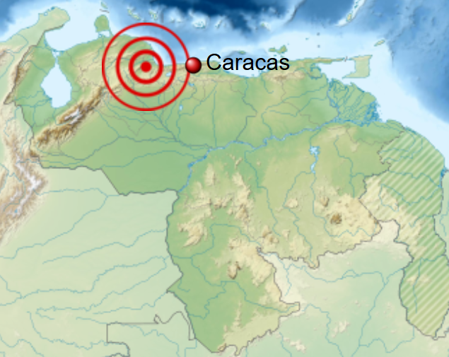
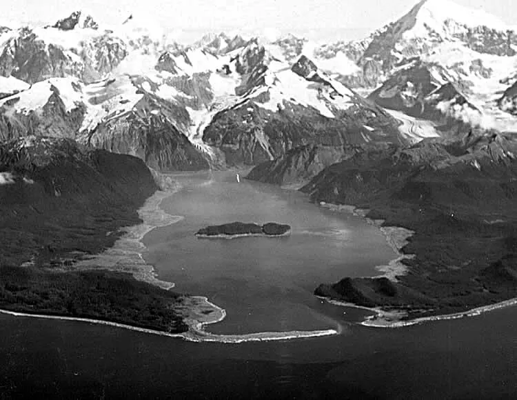
Lituya Bay sits on the Gulf of Alaska coast roughly 200 kilometers west of Juneau, on the “Lost Coast” wilderness below the Fairweather Range. It is a glacially carved tidal inlet about 11 kilometers long and up to 3 kilometers wide, dropping to a maximum depth of around 220 meters. At its mouth, La Chaussee Spit pinches the entrance down to a shallow sill, which makes the bay a rare sheltered anchorage along an exposed coast and turns its tidal currents violent.
The bay is shaped like a T. The stem runs inland from the Gulf; the crossbar at the head is formed by two arms, Gilbert Inlet to the north and Crillon Inlet to the south. Those two arms lie directly along the Fairweather Fault, a major strike-slip boundary where the Pacific Plate grinds northwest past North America. Glacial scour has exploited the weak rock along the fault to carve the long linear trench the inlets occupy. Three glaciers spill into the head of the bay, Lituya, North Crillon, and the smaller Cascade, and the walls around Gilbert and Crillon Inlets rise steeply, fjord-like, to thousands of feet. The combination is close to ideal for manufacturing a giant wave. The fault weakens the rock; the seismic source sits directly beneath it; the water at the head of the bay is deep enough to take a falling mountainside whole; and the basin is too narrow to let the resulting energy spread.
The danger was old news to the Tlingit, whose story of Kah Lituya, the “Man of Lituya,” describes a being who shakes the water to capsize those who enter his territory. When the French explorer Jean-François de Lapérouse anchored here in 1786, he named it Port des Français, he noted forest that looked “as though everything had been cut cleanly with a razor blade,” and lost 21 of his men when their boats capsized in the entrance current. The island at the bay’s center was named Cenotaph, an empty tomb, in their memory.
The Earthquake and the Rockslide
The earthquake that struck the Fairweather Fault that night is given a moment magnitude between 7.8 and 8.3, depending on the analysis, with a maximum Modified Mercalli intensity of XI (Extreme) near the bay. The modern USGS catalog value is Mw 7.8; the higher 8.3 figure derives from older estimates that the physical-modeling literature, including Fritz and colleagues, has continued to use. The shock was felt across some 400,000 square miles, from Seattle in Washington to Whitehorse in the Yukon. Surface breaks measured by Don Tocher and D.J. Miller a few miles southeast of Crillon Inlet recorded the offset directly. As Tocher (1960) put it, “A displacement in which the southwest side moved relatively northwest 21½ feet and up 3½ feet was measured at one point on the fault just east of the north end of Crillon Lake”, roughly 6.5 meters of horizontal slip, the kind of sudden ground motion that can shake a mountainside loose.
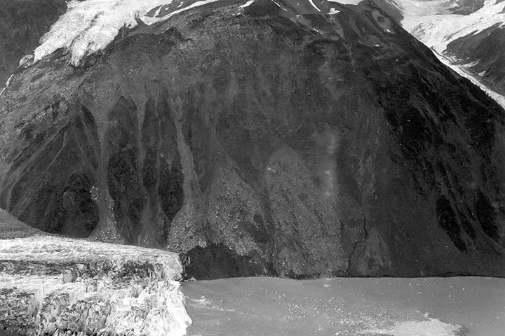
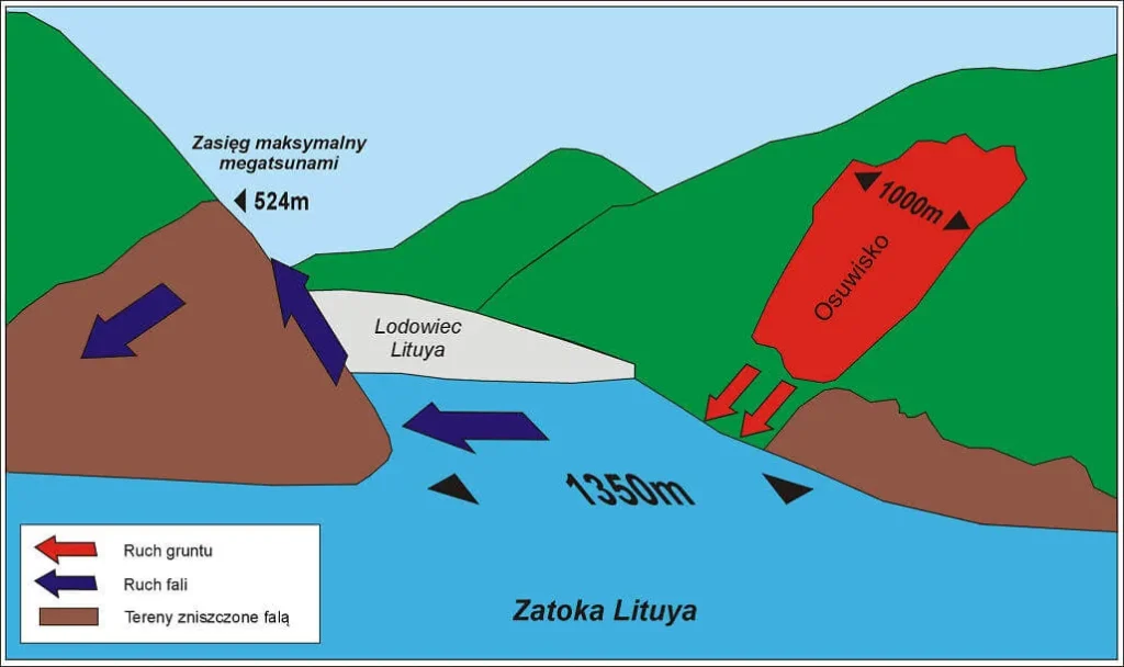
And a mountainside came loose. On the steep northeast wall of Gilbert Inlet, a slab of rock broke away from an altitude near 3,000 feet (about 914 meters) and plunged almost vertically into the deep water at the head of the inlet. By the Western States Seismic Policy Council’s summary, the chunk was “estimated to be 2,400 feet by 3,000 feet by 300 feet” and “dropped 2,000 feet” into the bay. Miller put the volume at about 40 million cubic yards, or 30.6 million cubic meters, on the order of 90 million tons of rock. The impact was heard 80 kilometers away.
The Wave
What the rock did to the water was extraordinary. The slide drove into Gilbert Inlet and threw water up the opposite slope, a spur ridge in direct line with the slide’s path, to an elevation of 524 meters, or 1,720 feet. Everything above that line was scoured away; Miller found bedrock left “as bare and clean as though washed down with a hose.” The impact also sheared roughly 400 meters (about 1,300 feet) of ice off the front of the Lituya Glacier.
From Gilbert Inlet the wave swept down the length of the bay. Ulrich watched it round Cenotaph Island, where it stood roughly 30 meters (about 100 feet) high, breaking on the north side of the island and staying smooth on the south where the Edrie rode. The wave snapped his anchor chain “like a string,” lifted the boat, and carried it toward the southern shore, Ulrich could see treetops below the hull, before a backwash dropped the Edrie back into the churning, log-choked center of the bay with father and son shaken but alive.
The Swansons on the Badger fared worse and survived anyway. The wave picked up their boat near the entrance and carried it stern-first over La Chaussee Spit; Bill Swanson said he looked down at spruce trees some 80 feet below the hull as the boat surfed backward across the barrier. Beyond the spit the wave broke and smashed the Badger down onto the bottom. A tree trunk crushed into the pilothouse, breaking several of Swanson’s ribs, but the couple escaped in their skiff with little more than the clothes they wore and were rescued about two hours later by the Lumen, which had answered Ulrich’s mayday. The Sunmore tried to run for the entrance and never made it; the wave caught it and drove it down, and the Wagners were never found. Five people died across the wider earthquake zone that night, including three at Yakutat and on Khantaak Island; the Wagners were the two killed by the wave itself.
“The wave did not go up 1800 feet—the water splashed there.”, Howard Ulrich, describing what he saw at the head of the bay
Don Miller Reconstructs the Impossible
The man best prepared to make sense of it was already in the neighborhood. D.J. Miller, a U.S. Geological Survey geologist, had been studying Lituya Bay’s strange forest trimlines since the early 1950s and was aboard a USGS barge in Glacier Bay when the earthquake struck; he watched rock fall from cliffs into the water there. The next morning he chartered a float plane and flew to Lituya Bay with pilot Kenneth Loken. They could not land, the surface was a raft of tree trunks and ice blocks extending miles out to sea. Miller saw hillsides dripping water, swollen streams, the vanished delta in Gilbert Inlet, the sheared glacier front, and high on the northeast wall the fresh rockslide scar still shedding stone.
Miller’s 1960 report, USGS Professional Paper 354-C, Giant Waves in Lituya Bay, Alaska, and his companion paper in the Bulletin of the Seismological Society of America, became the foundational documents of the field. He had initially suspected the fault motion itself produced the wave; once he saw the scale of the rockfall he concluded the slide was the cause. The Berkeley seismologist Don Tocher argued for the landslide source as well, pointing to the horizontal fault motion, the apparent radiation of the wave outward from Gilbert Inlet, and the delay Ulrich described between the shaking and the wave. Miller’s reconstruction reset how scientists thought about large waves, establishing that a falling mass of rock, not just seafloor displacement, could generate a wave dwarfing ordinary tsunamis. These are now called megatsunamis, defined as waves exceeding about 30 meters.
Miller did not live to extend the work. He drowned on the Kiagna River with a young assistant in 1961. A research vessel later named for him served as George Plafker’s base for studying the 1964 Great Alaska earthquake.
How Tall Was the Lituya Bay Wave? 524 Meters Is the Run-Up, Not the Height
The “524 meters” is almost always reported as the wave’s height, but it is the run-up: the maximum elevation the water reached as it splashed and surged up a slope, rather than the height of a wave standing in the bay. Ulrich said it plainly: the water splashed to that height; the wave did not stand 1,800 feet tall. The distinction matters because the run-up was produced by the slide’s momentum carrying water up a steep ridge directly opposite the impact, in a confined inlet that focused the energy.
When Hermann Fritz, Willi Hager, and colleagues rebuilt a cross-section of Gilbert Inlet at 1:675 scale and fired a pneumatic landslide generator into it to satisfy Froude similarity, the slide hit the water at a modeled mean velocity of about 110 meters per second, and the experiment reproduced the 524-meter trimline. In that physical model the wave crest itself was on the order of 150 meters (about 490 feet) tall. So the accurate picture is a wave roughly 150 meters high in the inlet that ran up to 524 meters on the opposing ridge, then traveled down the bay at perhaps 100 to 130 miles per hour as a wave tens of meters high. Earlier numerical work by Charles Mader had failed to reproduce the run-up from the displaced water of a simple rockfall alone; Fritz’s group showed that a high-speed slide drags a large air cavity into the water behind it, displacing far more volume than the rock itself.
The mechanism is still debated at the margins. In 2010 Steven Ward and Simon Day argued that the volume of sediment infilling the floor of Gilbert Inlet was far larger than the rockfall alone could explain, and proposed a “dual slide”: the rockfall sheared the toe of the Lituya Glacier and triggered a much larger, slower submarine slide of glacial sediment that helped drive the wave through the outer bay. Confirming that would require dating the sediment layers on the inlet floor. Nearly seven decades on, the broad picture is settled and the fine mechanics are not.
A Bay That Has Done This Before
The 1958 wave was not an aberration. Miller documented a sequence of earlier giant waves from the bay’s trimlines, dating them by tree rings and old photographs. His tally of maximum trimline altitudes: 1,720 feet in 1958; 490 feet on October 27, 1936; about 200 feet around 1899; about 80 feet around 1874; and 395 feet in 1853 or 1854. Each successive wave tended to erase the shoreline evidence of the ones before it, which is why the record is partly inferential and the dates carry question marks.
The causes varied. The 1936 waves were generated in Crillon Inlet, described by eyewitnesses as three waves of increasing height traveling about 22 miles per hour, with no associated earthquake recorded; Miller could not pin the mechanism. The 1853–54 event is tied to Tlingit accounts of a village abandoned on the north shore after canoes were lost. The 1899 wave may relate to the great Yakutat Bay earthquakes of that year. Whatever the trigger, the lesson Miller drew was blunt: Lituya Bay is a dangerous body of water that produces a few enormous waves per century, and it will do so again.
Megatsunami vs. Tsunami: Why Landslide Waves Behave Differently
A landslide-generated wave behaves nothing like the ocean-crossing tsunami most people picture. The familiar ocean-crossing tsunami comes from seafloor displacement along a long fault rupture; it has a very long wavelength, travels as a shallow-water wave at the speed set by water depth, loses little energy, and can devastate coastlines an ocean away. The 2004 Indian Ocean and 2011 Tohoku disasters were that kind.
A wave born from a localized mass dropping into a confined basin is different in character. Its source is small and roughly a dipole, its wavelength is much shorter, and it is far more affected by frequency dispersion. Close to the source it is ferocious, capable of run-ups no tectonic tsunami approaches; with distance it attenuates fast. The destructive reach of a landslide tsunami is essentially near-field. That is precisely why a wave can scour a fjord wall to 524 meters and yet register only centimeters on a tide gauge a few hundred kilometers away. The steep, narrow walls of a fjord concentrate the energy instead of letting it spread, which is the common thread linking Lituya Bay to every modern analog.
The Modern Hazard
For decades Lituya Bay looked like a freak of one remote inlet. It is now understood as one instance of a hazard that glacial retreat is making more common. When a tidewater glacier thins and pulls back, it removes the buttress that held the valley wall in place. The freshly deglaciated rock, often further weakened by thawing mountain permafrost, is left primed to fail. Jeffrey Coe and colleagues at the USGS documented the pattern directly: using Landsat imagery from 1984 to 2016, they cataloged 24 rock avalanches across a 5,000-square-kilometer area of Glacier Bay National Park, with a cluster of unusually large, mobile avalanches from June 2012 through June 2016, beginning about two years after the long-term mean annual maximum temperature in the area may have crossed 0°C. None of those were triggered by earthquakes.
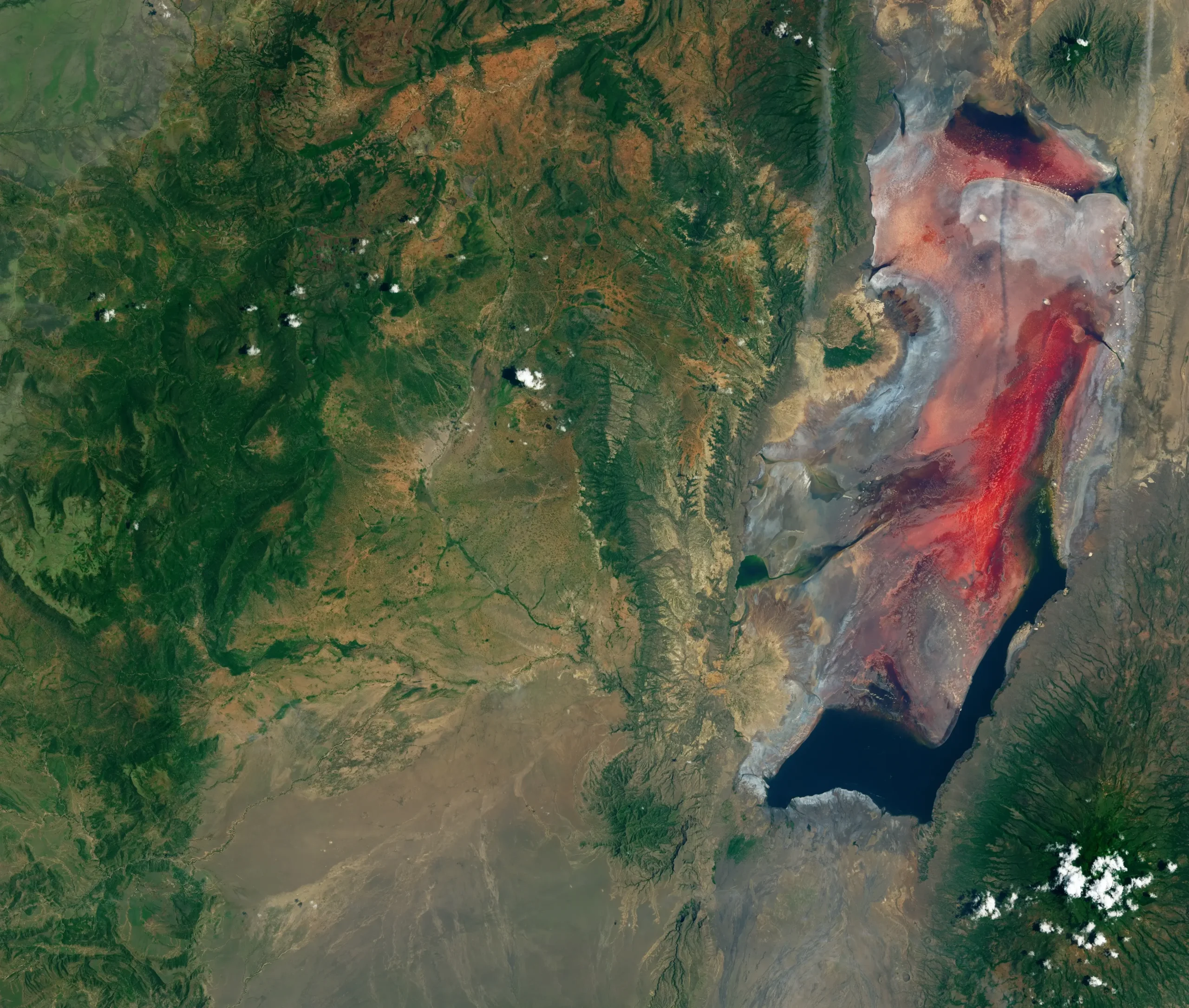
Taan Fjord, 2015
Tyndall Glacier had been retreating for half a century before the mountain above it let go. On October 17, 2015, a slope at the glacier’s terminus in Taan Fjord, an arm of Icy Bay in Wrangell–St. Elias, collapsed into the water. Bretwood Higman and colleagues, writing in Scientific Reports in 2018 (DOI 10.1038/s41598-018-30475-w), documented a slide of roughly 7.6 × 10⁷ cubic meters, about 180 million tons of rock, that drove a tsunami to a peak run-up of about 193 meters on the opposite slope. The U.S. National Park Service summary of the study calls it “the fourth highest ever recorded.” The slope had been primed by Tyndall’s retreat: the glacier thinned more than 400 meters and retreated 17 kilometers between 1961 and 1991. The authors framed the event as a clear consequence of deglaciation and a benchmark for modeling, and noted that precursory deformation had begun decades before failure.
Tracy Arm, 2025
The clearest echo of Lituya Bay came on August 10, 2025, in Tracy Arm, a narrow fjord southeast of Juneau threaded by cruise ships and kayakers. Dan Shugar of the University of Calgary and a large team published the reconstruction in Science on May 6, 2026, under the title “A 481-meter-high landslide-tsunami in a cruise ship–frequented Alaska fjord” (DOI 10.1126/science.aec3187, Science vol. 392, no. 6798). More than 64 million cubic meters of rock collapsed near the South Sawyer Glacier early that morning. The maximum run-up, measured by a helicopter-mounted altimeter, was 481 meters (±7.6 m) on the south side of the fjord, about 3.3 kilometers across from the slide, the second-highest run-up ever recorded, within about 150 meters of Lituya Bay’s record. The run-up followed an initial breaking wave about 100 meters high traveling more than 70 meters per second.
Unlike Lituya Bay, no earthquake triggered it; the slide had been preceded by several days of escalating microseismicity that intensified until roughly an hour before failure, and the slide itself produced globally recorded seismic waves equivalent to a magnitude 5.4 earthquake. Water continued to slosh inside the fjord as a seiche for up to 36 hours, generating a long-period (~66-second) signal recorded worldwide, only the second time a days-long seiche has been observed that way. The event was a near miss. The cruise ship Hanse Explorer had departed the area roughly twelve hours earlier; kayakers camped on Harbor Island some 55 kilometers away woke to water carrying off a kayak and their gear, and a small cruise vessel in neighboring Endicott Arm reported surging currents. Tracy Arm and Endicott Arm receive more than 20 vessels a day in summer, including large cruise ships carrying thousands of people. Shugar’s team warned that had the slide occurred hours later, with passengers ashore in small boats, the outcome could have been catastrophic. The disruption persisted into the next season: AP News reported on April 12, 2026 that “Cruise companies to Alaska are avoiding a popular excursion to Tracy Arm after a massive landslide,” with major lines rerouting to Endicott Arm and Dawes Glacier.
Barry Arm
The Barry Arm slope in Prince William Sound is the case scientists are watching before it fails. A citizen scientist flagged it in spring 2020, and Chunli Dai, Bretwood Higman, Patrick Lynett and colleagues documented it that year in Geophysical Research Letters (DOI 10.1029/2020GL089800): an unstable slope with a total volume of 455 × 10⁶ cubic meters in a recently deglaciated fjord. The slope moved rapidly between 2010 and 2017, displacing about 120 meters horizontally, closely correlated with the thinning and retreat of Barry Glacier. Their preliminary modeling of a worst-case scenario, the entire slope failing at once, suggested a maximum run-up of about 300 meters near the landslide.
What happened next shows science walking back its own alarm. The USGS Open-File Report 2021-1071 by Katherine Barnhart and colleagues ran more detailed simulations with new lidar and bathymetry. The worst case still produced run-up over 500 meters on the opposite fjord wall right at the source, and wave heights over 200 meters in northern Barry Arm. But at Whittier, the community about 50 kilometers away, the modeled peak was just over 2 meters offshore, arriving about 26 minutes after the slide, far below the roughly 30-foot (about 9-meter) figure that had circulated from the 2020 preliminary work. The USGS framed the refined assessment as “likely less severe than previously thought” for the towns, while stressing it would still be hazardous near the slope. As of early 2026 the Barry Arm landslide showed no large-scale active deformation, though smaller surface instabilities still pose a localized tsunami threat, and mariners are urged to stay alert.
Greenland
The phenomenon is not confined to Alaska. On September 16, 2023, a rock-and-ice avalanche of about 25 × 10⁶ cubic meters plunged into Dickson Fjord in East Greenland, generating a tsunami with an initial run-up near 200 meters. The wave became a seiche that sloshed back and forth for nine days, producing, in the words of Svennevig et al. in Science (DOI 10.1126/science.adm9247), “a 9-day-long, global 10.88-millihertz (92-second) monochromatic very-long-period (VLP) seismic signal” that registered on instruments from the Arctic to Antarctica and baffled seismologists. The Geological Survey of Denmark and Greenland describes the team that traced it as 68 scientists from 40 institutions in 15 countries. As in Alaska, the trigger was a glacier thinned by decades of warming until the mountain above could no longer be held up.
What It Means
Lituya Bay set the template, and the template is now repeating on a warming planet. The same conditions now describe a growing list of fjords across Alaska, Greenland, Norway, and British Columbia: deep water below slopes that glaciers have stopped bracing, stone fractured by old faults and fresh frost, and a shape that traps a wave instead of releasing it. The waves these collapses produce are local and brief, and almost unsurvivable at close range. Whether anyone dies comes down to where they happen to be standing. Howard Ulrich rode out the tallest wave ever recorded because his boat happened to face it on the smooth side of the swell. A mountain came down in Tracy Arm in 2025 and killed no one because it came down at 5:26 in the morning with no ship in the fjord. As the seismologist Jacqueline Caplan-Auerbach put it after Tracy Arm, nobody had been watching that slope as a place failure was expected, “and there are undoubtedly many places like this.”