Tuzo and Jason: The Continent-Sized Blobs Inside Earth
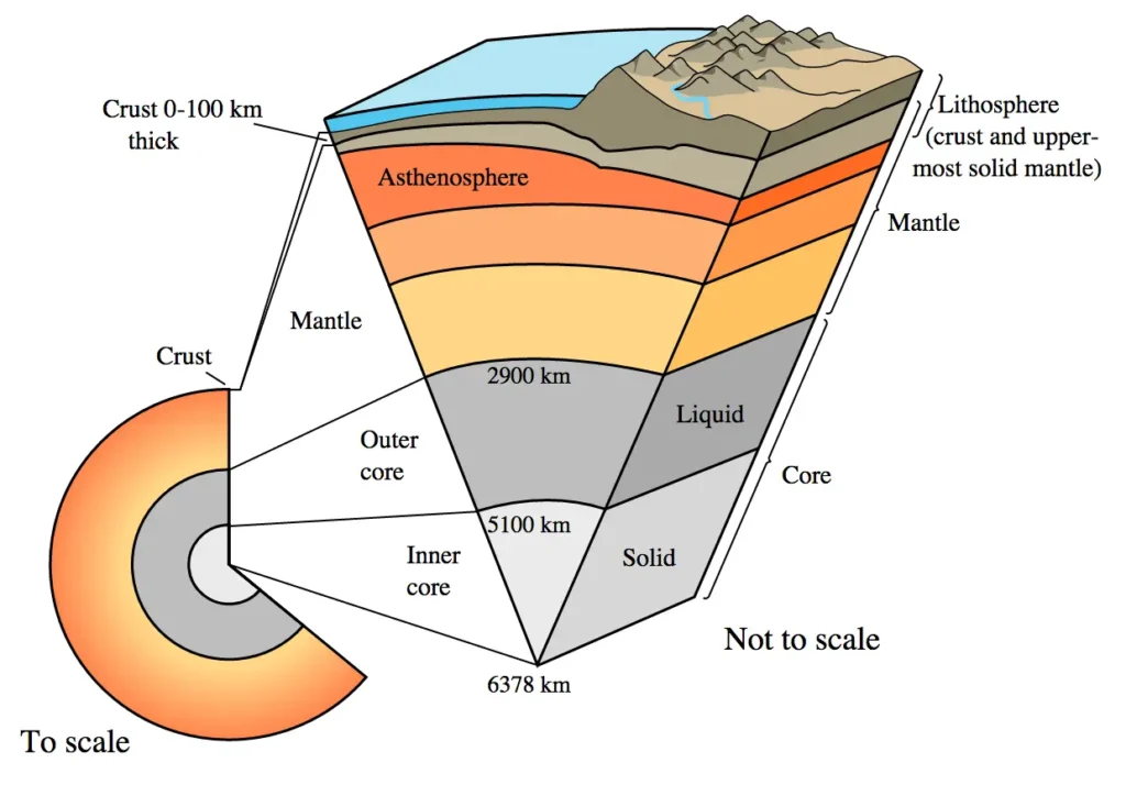
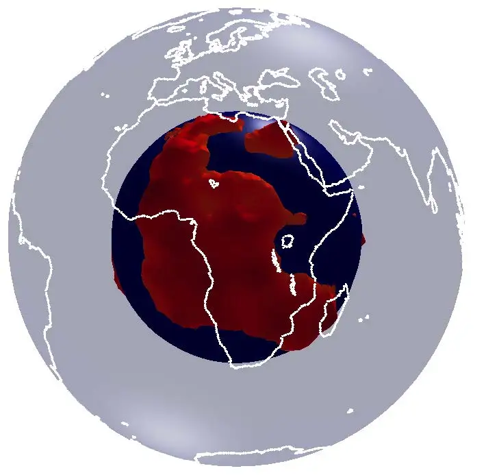
Drop straight down through the floor of the South Atlantic for 2,900 kilometres and you arrive at the core–mantle boundary, the most dramatic interface inside the planet. Above your head sits 2,900 kilometres of solid silicate rock. Below your feet, an ocean of molten iron sloshes around a solid inner core. And right here, draped across the boundary like a hot, sluggish hood, is one of the two largest objects in our planet that nobody has ever seen, only heard.
Seismologists have been listening to these objects for forty years. They call them Large Low Shear-Wave Velocity Provinces, or LLSVPs. The two of them together cover something like a quarter to a third of the core–mantle boundary surface, and each is wider than a continent. One sits beneath Africa and reaches well into the Atlantic and Indian Oceans. The other sits beneath the central Pacific. In 2011 the geologist Kevin Burke gave them backronyms: TUZO (The Unmoved Zone Of Earth’s deep mantle) for the African pile, JASON (Just As Stable ON the opposite meridian) for the Pacific one. Both names honour mantle-plume pioneers, J. Tuzo Wilson and W. Jason Morgan, and both encode Burke’s main claim, that the piles have stayed put for hundreds of millions of years.
What is an LLSVP
An LLSVP is a continent-sized region of Earth’s lowermost mantle, sitting right on the core–mantle boundary at roughly 2,900 km depth, where seismic shear waves slow by about 0.5 to 3 per cent compared with the surrounding mantle. A shear wave is the type of seismic wave that vibrates rock sideways as it travels; its speed depends on how rigid and how dense the rock is, so any slowdown means the rock is hotter, chemically different, or both. Two LLSVPs are known: Tuzo beneath Africa, Jason beneath the Pacific.
The slowdown is small in percentage terms and enormous in implication. Shear waves traversing the deep mantle behave like a flashlight on the floor of a cave: you cannot see the walls directly, but you can map them by how the beam bends. By the late 1980s seismologists had bent enough beams to be sure the lowermost mantle was not the smooth, hot soup the textbooks assumed. There were two antipodal regions where the rock was persistently different from its surroundings.
How we found them: tomography in the 1980s
Global seismic tomography is the technique of using thousands of earthquakes as floodlights, recording how their waves arrive at hundreds of seismograph stations, and inverting the travel times into a three-dimensional picture of Earth’s interior. The method matured in the early 1980s in the hands of Adam Dziewonski at Harvard and Don L. Anderson at Caltech. Dziewonski’s 1984 paper in the Journal of Geophysical Research, “Mapping the lower mantle: Determination of lateral heterogeneity in P velocity up to degree and order 6,” was the first to resolve the two antipodal, equatorial low-velocity domains at the base of the mantle. In an obituary for Dziewonski in Eos, Barbara Romanowicz and colleagues noted that he later preferred to call them “pillars of the Earth,” disliking the clumsy “LLSVP” name his community had settled on.
For two decades after Dziewonski’s paper the structures stayed peripheral to most mantle research. Burke, Steinberger, Torsvik and Smethurst’s 2008 paper in Earth and Planetary Science Letters moved them to the centre by pinning down their shape.
The geometry of two continents at the bottom of the world
The four authors laid tomography models on top of one another and contoured the regions where shear waves slow by at least 1 per cent. Tuzo and Jason emerged as two broad, lobate domes whose footprints together cover roughly 20 to 30 per cent of the core–mantle boundary. Each is several thousand kilometres across at its base. Each rises hundreds of kilometres into the mantle above the core.
How far up they rise is one of the longest-running fights in deep-Earth seismology. Garnero, McNamara and Shim in their 2016 Nature Geoscience review settled on “up to about 1,000 km” as a general figure. Yuan and Li’s 2022 Nature Geoscience study found that the African LLSVP is roughly 1,000 km higher than the Pacific LLSVP. Conversely, regional waveform modelling by Ni and colleagues had earlier pushed the African pile as high as 1,500 km. Tuzo is tall (perhaps a thousand kilometres or more), Jason is shorter and broader, and the boundaries are not flat. Numbers between 600 and 1,500 km appear in the literature and depend on which tomographic model and which velocity-anomaly threshold you trust.
The two piles sit very nearly opposite each other on the planet, both close to the equator. Yaoling Niu of Durham University points out in his 2018 paper that this position is not an accident. If you imagine two heavy masses on a spinning rotational solid, the stable equilibrium is for them to lie on the equator and 180 degrees apart, so their combined centre of mass sits on the spin axis.
Why they have stayed put for at least 320 million years
Persistence is the harder problem. Tuzo and Jason appear to have been parked at roughly their present locations since the Palaeozoic, while the continents above them migrated by tens of thousands of kilometres.
The 2014 Proceedings of the National Academy of Sciences paper by Trond Torsvik, Rob van der Voo, Pavel Doubrovine, Kevin Burke and colleagues at the Centre for Earth Evolution and Dynamics in Oslo made the case. They reconstructed the eruption sites of all the great flood-basalt provinces and kimberlite fields of the past 320 million years, restoring each to its position at the time of eruption using palaeomagnetic data. Almost every restored site landed above the present-day edge of either Tuzo or Jason. They then pushed the reconstruction back to 540 Ma, the start of the Cambrian, and found that the pattern still held within the resolution of their reference frame. The two thermochemical reservoirs at the base of the mantle, then, have not moved much, if at all, since complex life began.
“Since the Pangea supercontinent formed about 320 million years ago,” the Torsvik group wrote in the abstract of their 2014 paper, “plumes that sourced large igneous provinces and kimberlites have been derived from the edges of two stable thermochemical reservoirs at the core–mantle boundary.”
Where do Tuzo and Jason come from? Two leading ideas
The origin question is open, and arguments are sharp. Two hypotheses dominate the current literature, with a third (the Theia giant-impact idea) gaining attention since 2023.
- Subducted ocean crust graveyards (Niu 2018). The piles are the accumulated wreckage of basaltic oceanic crust that has subducted into the lower mantle over billions of years and sunk to the very bottom because, at lower-mantle pressures, transformed mid-ocean-ridge basalt is denser than the surrounding peridotite.
- Primordial core contamination (Deng, Miyazaki et al. 2025). The piles are the crystallised residue of an early basal magma ocean that was continuously fed by magnesium-oxide and silicon-dioxide grains exsolving out of the cooling metallic core some four billion years ago.
The subducted-crust hypothesis
Yaoling Niu’s 2018 paper in Geoscience Frontiers argued the case for piles of ancient subducted ocean crust, what Niu, somewhat morbidly, calls a “permanent graveyard” of slabs that have died beneath the trenches and never come back up. The argument rests on petrology. Mid-ocean-ridge basalt, once subducted and transformed under lower-mantle pressures and temperatures, becomes about 2.3 per cent denser than the ambient peridotitic mantle. Negative buoyancy at that magnitude is enough to defeat the upward push of mantle convection. Slabs that reach the core–mantle boundary sit there, accumulate, and build up over billions of years into thick basal piles. The piles act as thermal blankets that trap heat from the core and, at their edges where the temperature contrast is sharpest, generate the mantle plumes that drive surface volcanism.
Niu’s idea needs nothing exotic, just normal plate tectonics running for four billion years. The geochemistry is where it runs into trouble. Ocean-island basalts erupting today above the edges of Tuzo and Jason carry isotopic signatures (high 3He/4He, distinctive lead, neodymium and strontium ratios) that look more primordial than recycled. Mark Gleeson and colleagues, working on the Galápagos basalts in a 2021 paper in Geochemistry, Geophysics, Geosystems, found “little to no data” in those lavas to support the slab-graveyard model for the Pacific pile.
The core-contamination hypothesis
On 12 September 2025, Jie Deng of Princeton, Yoshinori Miyazaki of Rutgers, Qian Yuan of Texas A&M, and Zhixue Du of the Chinese Academy of Sciences published a paper in Nature Geoscience with the unwieldy title “Deep mantle heterogeneities formed through a basal magma ocean contaminated by core exsolution.” The acronym they coined for it (BECMO, for ‘basal exsolution-contaminated magma ocean’) is no friendlier.
Early Earth passed through magma-ocean stages, especially after giant impacts and during core formation. As the metallic core cooled and began to crystallise, light oxides (magnesium oxide and silicon dioxide) exsolved out of the liquid iron and rose into the deep silicate magma ocean above. Those oxides dissolved in the basal magma and altered its composition. As the magma ocean then crystallised from below, it produced a residue that was slightly denser than the rest of the mantle, but enriched in silicon rather than iron. The Deng group ran geodynamic simulations to show that this residue, swept by billions of years of mantle convection, would naturally clump into thick piles above the converging downwellings. The pictures look, to a first approximation, like Tuzo and Jason.
“They are fingerprints of Earth’s earliest history”, Miyazaki said in a Rutgers press release. announcing the paper. “If we can understand why they exist, we can understand how our planet formed and why it became habitable.” The model also reproduces the small, dense, ultra-low-velocity patches that hug the core–mantle boundary inside and around the piles, which earlier basal-magma-ocean models could not.
The 2025 paper does not retire the subducted-crust hypothesis. But it does change the conversation. The piles may have been seeded primordially and then topped up by slabs over four billion years, in which case Niu and Deng are both partly right.
There is a third option still in play: Qian Yuan and Mingming Li argued in Nature in November 2023 that fragments of Theia, the Mars-sized impactor that formed the Moon, sank through the early mantle and survived as Tuzo and Jason. That paper rests on the assumption that the lower half of the mantle did not melt completely during the giant impact. Independent geochemical tests of the prediction (whether Tuzo and Jason carry a Theia-like isotopic signature distinct from both subducted crust and primordial residue) have not yet been done.
Older interpretations: the thermochemical pile
Before BECMO and before the Theia idea, the consensus model for the LLSVPs was the ‘thermochemical pile,’ a phrase that crops up in almost every review since Edward Garnero and Allen McNamara introduced it in Science in 2008. The pile model treats Tuzo and Jason as chemically distinct, denser-than-average mantle material that has piled up at the base of the mantle and is being shaped from the outside by the cold, downwelling slabs of plate tectonics. The shape of the piles is set by where slabs are not landing.
Allen McNamara’s 2019 review in Tectonophysics is the standard summary. The piles, he argued, are very probably compositionally distinct from the surrounding mantle, denser at their base, and the source of the plumes that feed hotspot volcanism. What he could not say, and still cannot, is what they are made of. The 2016 review by Garnero, McNamara and Shim in Nature Geoscience made the same admission with the same caveats. The existence of the piles, their excess density, and their longevity are all reasonably well established by seismology and palaeomagnetic reconstruction. Their chemistry is not.
The plume connection: why volcanoes know where the blobs are
Take the active hotspots, the great flood-basalt provinces, and the kimberlite fields of the past 320 million years, and restore each one to its eruption-time position. More than 90 per cent of them sit above the edges of Tuzo or Jason. That is the central finding of Burke and Torsvik (2004), refined by Burke, Steinberger, Torsvik and Smethurst (2008), and confirmed again by Torsvik et al. (2014).
The narrow ribbons where the shear-wave velocity drops sharpest at the core–mantle boundary, the LLSVP margins, are called plume generation zones. The piles are hotter than the surrounding mantle (because the core is hot, and the piles insulate it). At their margins, where temperature contrast is steepest, the mantle becomes unstable and lifts off in narrow plumes that rise the entire 2,900 km to the lithosphere. When a plume head arrives under a plate, it melts; the result is a flood basalt province, an oceanic plateau, or a long-lived hotspot track.
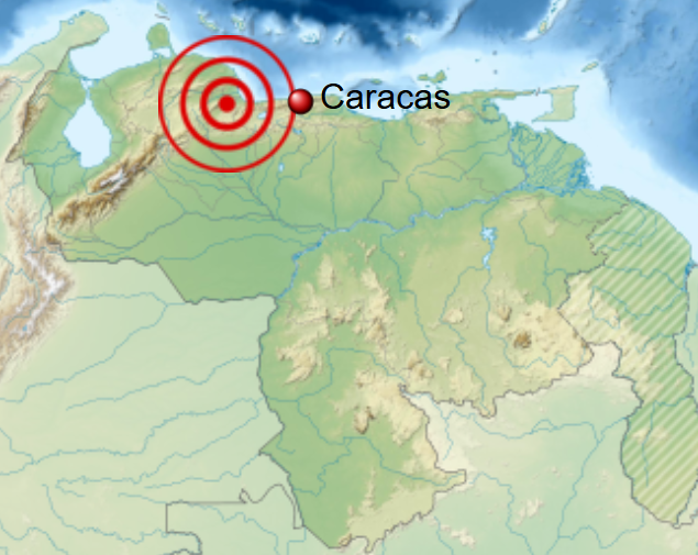
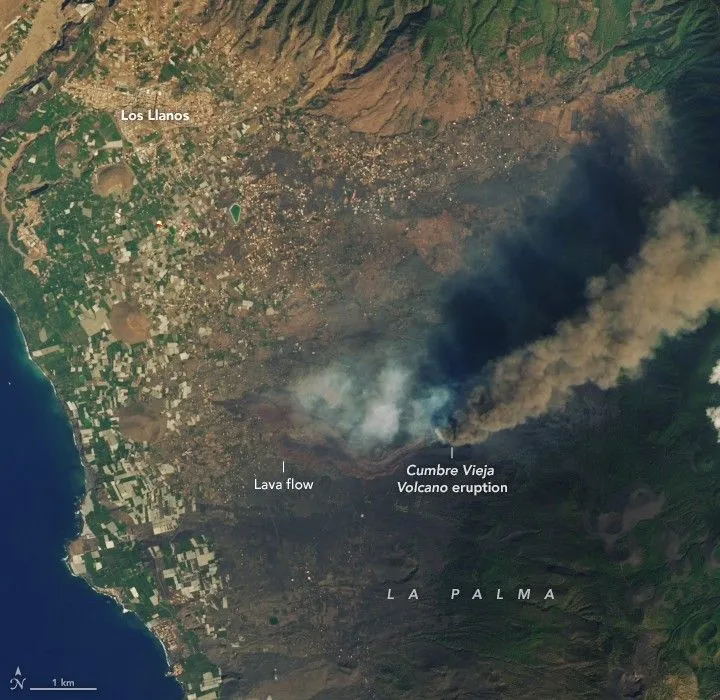
Specific examples line up with the geometry. Hawaii sits above the western edge of Jason. Iceland is often associated with the northern margin of Tuzo, though its plume root’s exact relationship to the African LLSVP is still debated. Réunion, source of the Deccan Traps that erupted 66 million years ago at the Cretaceous–Palaeogene boundary, lies above Tuzo’s eastern flank. The Canary Islands, including La Palma, which erupted in September 2021, sit above Tuzo’s northwest edge. Samoa sits above Jason’s southern edge and overlies one of the largest mapped ultra-low-velocity zones. The Siberian Traps, which erupted 252 million years ago at the Permian–Triassic boundary, project down to the small PERM anomaly, which several authors interpret as a northeastern arm of Tuzo.
The Siberian connection is the heaviest of the six. The Siberian Traps are the largest exposed continental flood-basalt province on Earth, and their eruption coincided with the worst mass extinction in the fossil record. The end-Permian event wiped out roughly 81 per cent of marine genera and the majority of land vertebrate families, the most severe biotic crisis in the Phanerozoic record. A 2023 paper in Nature Communications by Li and colleagues at Jilin University found electromagnetic evidence of a high-conductivity anomaly in the mantle transition zone beneath the Siberian craton, sitting almost directly above the PERM anomaly. They interpret it as the cooling remnant of the superplume that fed the Siberian Traps: a fossil plume caught mid-decay.
The Deccan Traps, smaller but still vast, erupted in pulses over the few hundred thousand years bracketing the asteroid impact at Chicxulub. A 2024 modelling study in the Journal of Geophysical Research: Solid Earth by Ghosh and colleagues linked those pulses to a thermochemical plume rising from the eastern flank of the African LLSVP. The non-avian dinosaurs died during a crisis dominated by the Chicxulub impact, with Deccan volcanism remaining a major debated contributor to the environmental stress around the boundary. If Ghosh and colleagues are right, the Deccan eruption itself traces back to a plume rising off Tuzo’s eastern flank.
The little patches at the edges: ultra-low velocity zones
If you zoom in on the margins of Tuzo and Jason at high resolution, you find something stranger still. In isolated patches measuring tens of kilometres thick and hundreds of kilometres across, the seismic-wave slowdown is no longer a gentle 3 per cent. It is up to 50 per cent for shear waves and roughly 10 per cent for compressional waves. These are the ultra-low-velocity zones, or ULVZs. They cluster at the LLSVP edges like fringes on a rug.
The largest known ULVZ sits beneath the Hawaiian hotspot. It is roughly 1,000 km across and 20 km tall, and its very low shear-wave velocities suggest something close to partial melt or extremely iron-rich material. A second mega-ULVZ sits beneath Samoa, about 800 by 250 kilometres in plan and shear-velocity reduction of around 45 per cent. Maxim Ballmer, Sanne Cottaar and colleagues have argued that these mega-ULVZs may be the deep anchors of whole-mantle plumes, marking the precise spot on the core–mantle boundary where a hotspot’s roots terminate.
Recent seismic-array work has begun to map ULVZs in regions that were previously dark. A 2024 paper in the Journal of Geophysical Research: Solid Earth by Agboola and colleagues used PcP-wave double-array stacking, taking advantage of the spread of new broadband stations south of about 30°S, to image ULVZ structure beneath the southern hemisphere, including beneath the southern Indian Ocean. They found patchy, variable ULVZ structure even far from the LLSVP edges, which complicates the neat picture of ULVZs as fringe ornaments and hints that they may form by multiple processes. Maureen Long and Jonathan Wolf, in a 2023 paper in Geochemistry, Geophysics, Geosystems, mapped two previously undetected ULVZs to the south-east of Hawaii and showed that seismic anisotropy and ULVZ material co-locate at the Pacific LLSVP edge, hinting that the deep mantle there is flowing in a measurable direction.
Whether ULVZs are pockets of partial melt, dense iron-rich oxide accumulations left over from a magma ocean, or piles of ancient subducted banded iron formation, is unresolved. The 2025 Deng paper suggests that diapirs of core-exsolved oxide could account for at least some of them, which would make ULVZs the most directly observable consequence of a leaking core.
What we still don’t know
For all the progress, the basic chemistry of Tuzo and Jason remains a hypothesis. The density question is still unsettled. Tidal tomography by Lau and colleagues inferred that the lower two-thirds of the LLSVPs may be about 0.5 per cent denser than the surrounding mantle, although that excess mass could be concentrated near the very base. Stoneley-mode work by Koelemeijer, Deuss and Ritsema found the opposite tendency for the structures as a whole: their data were best fit by lower overall LLSVP density, while not ruling out a thin, denser basal layer. In other words, even the sign of their net buoyancy is still model-dependent. They have sharp edges where shear-wave velocity changes by several per cent over a few tens of kilometres: too sharp to be purely thermal, almost certainly compositional. They are stable on the 320-million-year timescale of reconstructed flood basalts and seem stable on the 540-million-year timescale of Torsvik’s full Phanerozoic reconstruction. None of that tells us, definitively, what they are made of.
A few questions are still open. Are the piles net buoyant the piles (hot but compositionally distinct, lifted by their temperature) or are they net dense (chemically heavier, holding their position despite being hot)? Different normal-mode studies give different answers. Are their edges as sharp as the seismology suggests, or is the sharpness an artefact of how tomography handles fast lateral gradients? Are they truly stable on billion-year timescales, or do they shift slowly and merely appear stable because our resolution back through deep time is poor? A 2017 modelling paper in Nature by Flament, Williams and colleagues argued that “Perm-like” anomalies can be born, migrate at one centimetre per year, and reabsorb. So absolute stillness may be a story we have told ourselves.
One of the most promising new probes is mineralogical. Super-deep diamonds, rare gems that crystallise between about 300 and 1,000 km depth and arrive at the surface as inclusions in kimberlite pipes, carry tiny fragments of lower-mantle minerals, ferropericlase, bridgmanite, CaSiO₃-perovskite, ringwoodite, locked inside them. As Fabrizio Nestola and colleagues have argued in Communications Chemistry and elsewhere, these inclusions are direct samples of mantle material from depths normally inaccessible. Kimberlite eruption sites cluster at LLSVP edges, which means the diamonds they carry may be the closest physical samples humanity will ever have of the rock surrounding Tuzo and Jason. The chemistry of their inclusions, especially the iron and oxygen content, is exactly what we need to test whether the piles are subducted ocean crust, primordial residue, or both.
Why this matters at the surface
The reason to care about two structures 2,900 km beneath your feet is that they appear to choose where Earth’s biggest volcanic catastrophes happen. Flood basalts on the scale of the Siberian Traps or the Deccan Traps are not common events (perhaps a dozen in the last 300 million years) and at least three of them coincide closely with mass extinctions. The Siberian Traps at 252 Ma marks the worst extinction in the fossil record. The Central Atlantic Magmatic Province at 201 Ma marks the end-Triassic extinction. The Deccan Traps at 66 Ma overlapped with the end-Cretaceous extinction that killed the non-avian dinosaurs.
If Torsvik and Burke are right, every one of those provinces was fed by a plume that rose from the edge of Tuzo or Jason. The chain runs through the plumes, not straight from the piles. Lava and volcanic gases on the surface are what kill species, over thousands to millions of years. The piles only sit at the start of the chain, generating the plumes that feed the eruptions. They are the long, slow underlying pattern beneath the catastrophes.
This is also why the September 2025 Deng paper attracted the press attention it did. The Princeton–Rutgers group pushes further than tracing the seeds of the LLSVPs to roughly four billion years ago. They argue that the chemistry of the material exsolved from the cooling core may have made early Earth uniquely habitable, by influencing core convection, magnetic-field generation, and the delivery of light elements to the deep mantle reservoirs that later fed early plume volcanism. The chain of reasoning is long and most of its links are still being tested. That researchers are willing to draw it at all is a measure of how central the LLSVPs have become to almost every story about how this planet came to be the way it is.
A continent, but not really
It is tempting to call Tuzo and Jason “continents at the bottom of the world.” The comparison has some merit: they are continent-scale, chemically distinct from the rock around them, and they have stayed in roughly the same place for hundreds of millions of years. The metaphor breaks down where you would expect. They are not rigid plates and they do not move as a unit. They flow on geological timescales, in the way that all mantle rock flows, but they flow more slowly than the rock around them and they stay in roughly the same place while continents above them migrate by tens of thousands of kilometres. They are also, almost certainly, much hotter than continents (perhaps 200 to 300 K above the ambient lower-mantle temperature), and that excess heat is one reason their margins are good at launching plumes.
Two structures the size of continents, on opposite sides of the planet, between them generate the plumes that have driven some of the largest volcanic events in Earth history. What looked like a smear in Dziewonski’s 1984 tomography model is now a feature of the deep Earth that has a name and a contested origin story. Three things should sharpen the picture over the next decade: denser broadband seismic arrays in the southern hemisphere and the oceans, where station coverage is still thin; new super-deep diamond inclusions from kimberlite fields that sit above the pile margins; and mineral-physics experiments running at pressures closer to those of the core–mantle boundary itself.
Until then they sit where they have sat for at least 320 million years, 2,900 kilometres below us, the deep source of the plumes that built the Deccan and the Siberian Traps.