A new thermochronology study from the North China Craton argues that supercontinent tectonics, not Cryogenian glaciation, removed most of the rock missing beneath Earth’s most famous gap in time.
A Hand on the Boundary
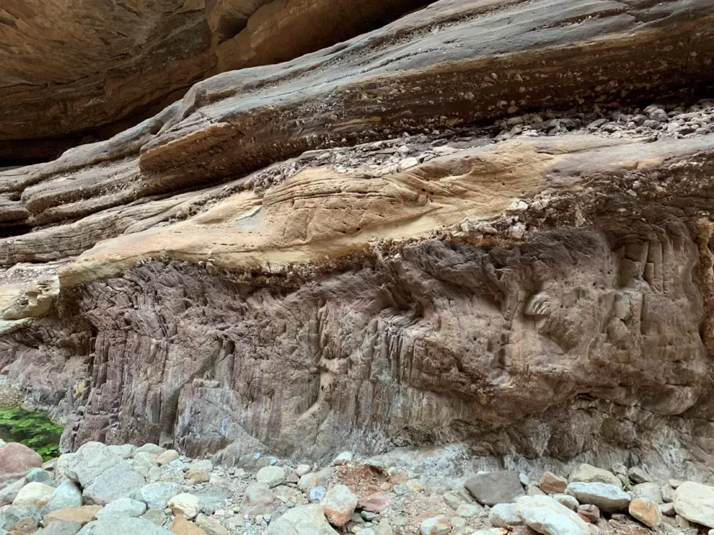
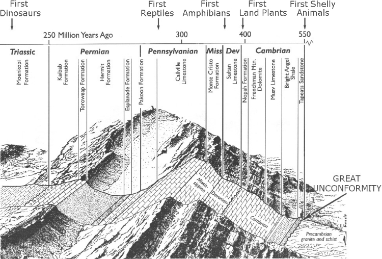
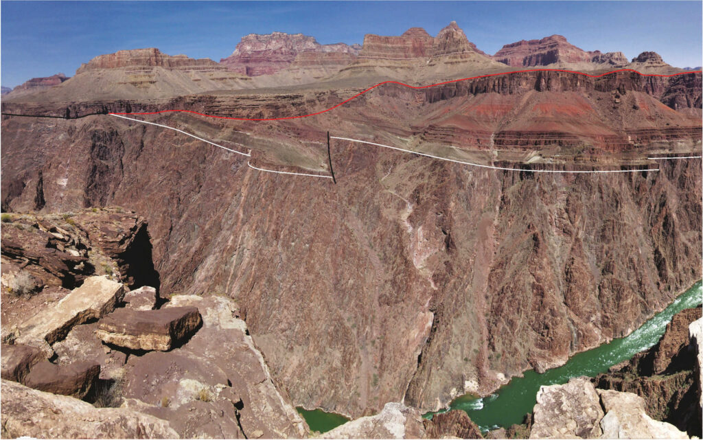
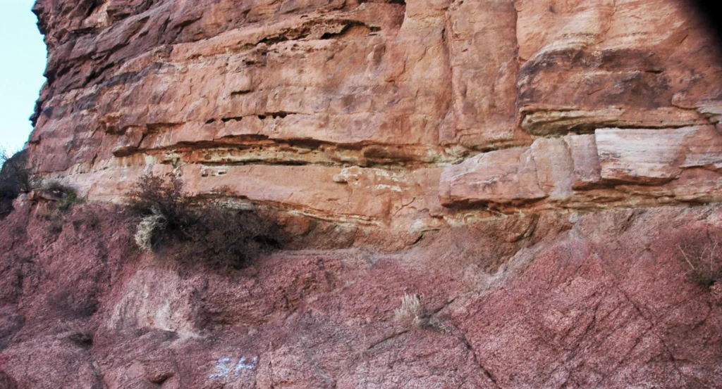
At River Mile 120 on the Colorado, a slot called Blacktail Canyon opens into the Inner Gorge of the Grand Canyon. The walls close in until a hairline contact comes down to chest height. Below the line is dark, vertically foliated Vishnu Schist, around 1.75 billion years old, threaded with pink Zoroaster Granite. The tan, horizontally bedded sandstone above it is the Tapeats, about 505 million years old. The line itself is the width of a pencil mark. Press a fingertip into it and the skin spans roughly a quarter of Earth’s history. This is one of the classic exposures in the Grand Canyon type area of the Great Unconformity: the surface where John Wesley Powell, in the summer of 1869, first described a gap of more than a billion years between the rocks at his feet and those above his head.
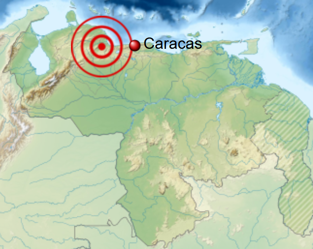
Eleven thousand kilometers away, in the southernmost Lüliang Mountains of Shanxi Province, an equivalent sub-Cambrian unconformity appears on a different craton. The site is logged in field notes as Xiweikou, 35°43′42.33″ N, 110°43′11.85″ E. Here, on the cratonic interior of North China, ~520-million-year-old nearshore sandstone sits directly on a 2,182-million-year-old granitic basement (Zhan et al., 2026, PNAS, 123(9), e2523891123, DOI: 10.1073/pnas.2523891123). The sample bags from Xiweikou, and from four other sites strung across the craton, were processed at Northwest University in Xi’an and at the University of Padova in northern Italy. Their zircons are the central evidence in a paper that returns to a long-running question: what removed the rock that should have recorded Earth’s missing billion years?
What Powell Saw in 1869
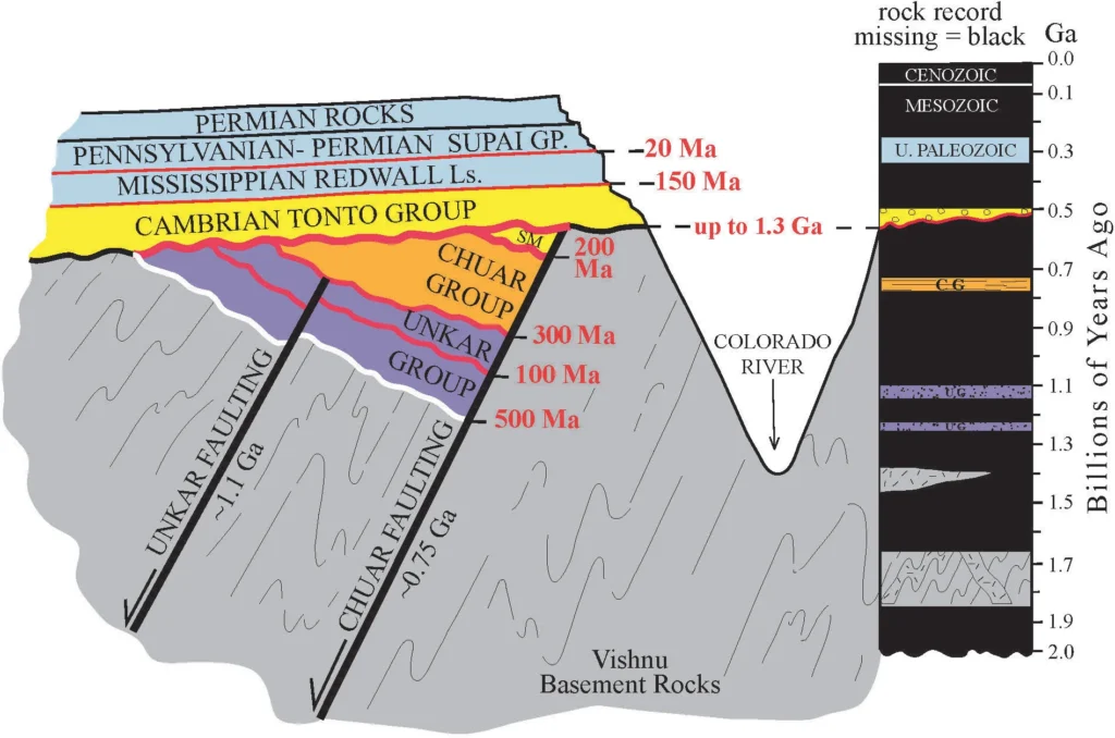
Powell launched from Green River, Wyoming, on May 24, 1869, with ten men and four wooden boats. He had lost his right arm below the elbow at Shiloh seven years before, and he had no detailed maps of the canyons downstream. By August, the expedition had ground its way into what Powell named Marble Canyon and then into the Granite Gorge of the eastern Grand Canyon. There, where the river cuts through schist and granite, the geologist saw something he could not yet date but could plainly read: flat, fossil-bearing sandstone resting on tilted, contorted, foliated basement. In his 1875 report, Exploration of the Colorado River of the West and Its Tributaries, Powell drew a stratigraphic section with two erosional surfaces marked at “x” and “y” (Powell, 1875). Seven years later, Clarence Dutton named the lower surface the Great Unconformity in his Tertiary History of the Grand Cañon District (1882).
Powell understood the surface as a record of mountain ranges raised and worn down before any Cambrian sea covered them (McKee, paraphrased in Karlstrom and Timmons, 2012). Radiometric dating did not yet exist. Powell could see that time was missing but had no way to quantify it. Modern measurements have since pinned the Tapeats Sandstone at ~505 Ma and the underlying Vishnu Basement Rocks at ~1.75 Ga, giving the contact at Blacktail roughly 1.2 billion years of missing record (NPS, “Missing Time at Grand Canyon”). Where the Tapeats falls on still older basement elsewhere along the canyon, the figure rises to roughly 1.6 billion years.
Twelve years before Powell’s expedition, John Strong Newberry had already noticed a similar gap along the lower Colorado River during the 1857–58 Ives expedition, but the Civil War interrupted publication and Powell’s account became the famous one. Alka Tripathy-Lang traced the lineage in a 2022 Eos retrospective.

A Similar Gap on Many Cratons
Similar sub-Cambrian unconformities appear on many continental cratons, especially where Cambrian or near-Cambrian sandstones rest directly on much older crystalline basement. On the Laurentian craton, the ancient core of North America, it runs from the Grand Canyon to the Front Range of Colorado, where 1.08 Ga Pikes Peak granite meets the Cambrian Sawatch Sandstone at the base of Manitou Springs (Flowers, Macdonald, Siddoway, and Havranek, 2020, PNAS, 117(19), 10172–10180, DOI: 10.1073/pnas.1913131117). In the Ozark Plateau of Missouri, Precambrian rhyolites of the St. Francois Mountains lie under Cambrian sediment with about a billion years of time missing between them (Joel, 2018, Eos, “Erasing a Billion Years of Geologic Time Across the Globe”). Around the western shore of Lake Superior, the structurally inverted Midcontinent Rift system is capped by the surface; thermochronology there indicates the basement experienced nearly a billion years of quiet stability beneath it (Hodgin et al., reported in Eos, “Structural Inversion of an Intracratonic Rift System in Deep Time”). The Shoshone Canyon exposure in Wyoming juxtaposes Archean crystalline rocks of the Wyoming craton, around 2.65–2.80 Ga, against 520 Ma Cambrian Flathead Sandstone, a gap of more than two billion years.
Outside Laurentia, the surface persists. On Baltica, the cratonic block beneath Scandinavia and the East European Platform, late Precambrian basement lies under Cambrian cover with hundreds of millions of years missing. On Amazonia, the Brazilian shield shows the same gap. The Karlstrom-Thurston team’s 2024 GSA Bulletin synthesis (Thurston, Guenthner, Karlstrom, Heizler, Ricketts, and McDannell, 2024, GSA Bulletin, 136(11–12), 4815–4835, DOI: 10.1130/B37358.1) lists comparable thermochronologic patterns on the Canadian Shield, the Wyoming craton, and the Colorado Plateau. And in the southernmost Lüliang Mountains of the North China Craton, the Xiweikou site of Zhan et al. (2026) shows the same contact: ~520 Ma sandstone on ~2.18 Ga granitic basement, with cratonic-margin sites at Subaigou and Luotuoshan showing shorter gaps that grow longer toward the craton interior.
Though the pattern spans every continent, the age of the contact varies considerably from site to site. At Frenchman Mountain east of Las Vegas, the strata are tilted ~50° and the Tapeats-on-Vishnu contact is accessible from a short walk off Lake Mead Boulevard (Rowland, UNLV; Las Vegas Sun, July 2024). On the Indian Peninsula, the Eparchaean Unconformity at Tirumala spans the Archean basement and overlying Cuddapah strata. Each site preserves its own clock, and whether all those clocks read the same time has become the central question.
The Snowball Earth Hypothesis
By the 2010s, two large hypotheses had emerged for what removed kilometers of crust at roughly the same point in the rock record on so many continents. The first, the glacial hypothesis, was given its modern form by C. Brenhin Keller and colleagues in PNAS (Keller, Husson, Mitchell, Bottke, Gernon, Boehnke, Bell, Swanson-Hysell, and Peters, 2019, PNAS, 116(4), 1136–1145, DOI: 10.1073/pnas.1804350116). Working from the global preserved sedimentary rock volume, which jumps by more than a factor of five across the Phanerozoic-Proterozoic boundary, and from oxygen and hafnium isotope excursions in detrital and magmatic zircon, the team argued that an enormous, geographically broad erosional event coincided with the Cryogenian glaciations. They estimated a global average of 3–5 vertical kilometers of continental denudation, distributed by repeated ice sheets that scoured whatever stood above sea level during the snowball intervals.
Continental ice sheets, when thick and warm-based, scour cratonic interiors as well as their margins. Mantle convection and tectonics, by contrast, drive uplift mainly at plate boundaries. An erosion event reaching deep into every continent more or less synchronously would point to ice, not tectonics. The Cryogenian Period offered two candidate snowballs of the right magnitude. Cryogenian glaciation is now constrained by Re-Os geochronology to two long, synchronous events: the Sturtian, from 717 to 660 Ma, and the Marinoan, lasting from sometime after 651 Ma to 635 Ma (Rooney, Strauss, Brandon, and Macdonald, 2015, Geology, 43, 459–462, DOI: 10.1130/G36511.1).
The Keller model also connected the erosion event to early animal evolution. If glaciers stripped continents of weatherable rock and dumped sediment into shallow seas, the resulting nutrient flux could fertilize early animal ecosystems. The Cambrian explosion, the rapid appearance of nearly all major animal phyla beginning around 539 Ma, would then follow the Snowball Earth as a kind of geochemical aftershock. Shanan Peters and Robert Gaines had argued for that linkage in Nature in 2012; Keller and colleagues placed it on a global isotopic foundation.
The Tectonic Hypothesis
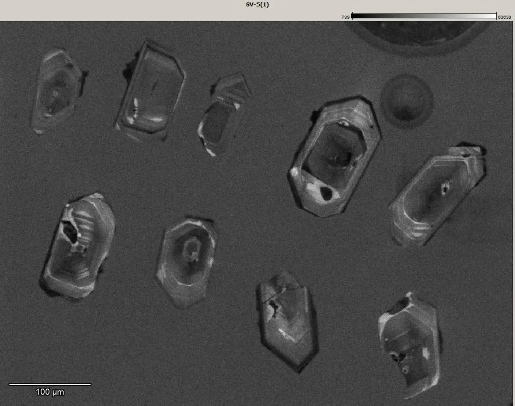
The competing hypothesis came from a Colorado outcrop near the mountain town of Manitou Springs. There, Rebecca Flowers of the University of Colorado Boulder and her collaborators sampled the contact between the 1.08 Ga Pikes Peak granite and the overlying Cambrian Sawatch Sandstone. They extracted zircon grains and ran them through zircon (U-Th)/He thermochronology, a method sensitive to the temperature history of a rock as it cools through about 200°C, the temperature at which a mineral begins to retain the helium produced by radioactive decay of uranium and thorium.
The Pikes Peak data did not fit the snowball model. The bulk of the cooling, and therefore the bulk of the kilometers-scale erosion, had already happened before the Cryogenian (Flowers, Macdonald, Siddoway, and Havranek, 2020). At Pikes Peak, an estimated 3–5 km of crust came off before 717 Ma, leaving little for the snowball glaciers to remove. Geological corroboration came in the form of Tavakaiv injectites, sand bodies forcibly intruded into the granite during the Sturtian, which can only have formed if Cambrian-equivalent sand was already at the surface, meaning the basement had already been exhumed (Flowers et al., 2020). The team concluded that “multiple, regionally diachronous Great Unconformities” existed, and that they were tectonic in origin.
A year later, Barra Peak, working in the same Boulder thermochronology lab, took the method to the Grand Canyon itself (Peak, Flowers, Macdonald, and Cottle, 2021, Geology, 49(12), 1462–1466, DOI: 10.1130/G49116.1). Peak and colleagues sampled crystalline basement above and below the eastern-to-western Grand Canyon transect and produced zircon (U-Th)/He dates as old as 809 ± 25 Ma. The dates varied across faults at scales of tens of kilometers, which can only be explained by syndepositional normal faulting during the Mesoproterozoic and Neoproterozoic, exactly the kind of multiphase tectonic activity expected during Rodinia assembly and breakup. Olivia Thurston and colleagues, working with Karl Karlstrom at the University of New Mexico and William Guenthner at the University of Illinois, extended the dataset in 2024 with combined zircon (U-Th)/He and K-feldspar 40Ar/39Ar measurements, again finding deep, multi-stage cooling well before 717 Ma (Thurston et al., 2024).
Zhan and colleagues’ 2026 paper tests the tectonic argument on a continent outside Laurentia.
What Thermochronology Actually Measures
Thermochronology rests on a single physical fact: helium leaks out of zircon at a rate that depends sharply on temperature. Zircon crystals, ZrSiO₄, incorporate trace uranium and thorium when they crystallize from magma. Those isotopes decay through long chains, producing alpha particles that thermalize into ⁴He atoms trapped in the crystal lattice. At temperatures above roughly 200°C, helium diffuses out of zircon fast enough that any accumulated helium escapes. Below about 140–180°C, depending on the zircon’s accumulated radiation damage, helium begins to be retained. The transition between these states is the “partial retention zone.”
Zircon (U-Th)/He dating measures the modern ratio of helium to its parent uranium and thorium, which yields the age at which the grain cooled through that retention threshold. Because zircon grains in a basement sample can carry different amounts of radiation damage, and because damage changes diffusion behavior, a single rock can yield a spectrum of dates that, modeled together, reconstruct a time-temperature path stretching back more than a billion years (Guenthner, Reiners, Ketcham, and others have developed the radiation-damage diffusion framework). When combined with K-feldspar 40Ar/39Ar thermochronology, which is sensitive to a higher temperature window of 150–350°C, the two methods together constrain a rock’s path from depths of tens of kilometers to the surface. Basement exhumation, the rise of crystalline rock toward the surface as overlying material is stripped away, is recorded in those cooling curves.
Converting temperature to depth requires an assumed geothermal gradient. Most studies use 20–30°C per kilometer, the modern value for stable continental crust. Zhan et al. (2026) note this assumption explicitly in their discussion of uncertainties: a different gradient changes the depth estimate but not the timing of cooling. The timing, the shape of the curve, where it falls steeply and where it flattens, lets the method distinguish a rapid Cryogenian event from a protracted Proterozoic one.
The 2026 PNAS Result
Rong-Ruo Zhan and eleven coauthors, a team based at Northwest University in Xi’an, the University of Padova, the Chinese Academy of Sciences, and Columbia University’s Lamont-Doherty Earth Observatory, published their results in PNAS on February 23, 2026 (Zhan, Duan, Zattin, Christie-Blick, Wan, Wei, Yang, Wang, Gou, Olivetti, Chen, and Zhang, 2026, PNAS, 123(9), e2523891123, DOI: 10.1073/pnas.2523891123). The paper combines field observations at five sites in North China with a battery of dating methods: zircon and monazite U-Pb, biotite and muscovite Rb-Sr, and zircon (U-Th)/He thermochronology. Three sites , Qingshuihe, E’hutan, and Xiweikou, sit in the cratonic interior. Two, Subaigou and Luotuoshan, sit on the cratonic margin.
The interior sites, including Xiweikou with its 2,182-million-year-old granitic basement under 520-million-year-old sandstone, record cooling histories that look nothing like a Cryogenian pulse. The basement rocks cooled most rapidly between about 2.1 and 1.6 billion years ago. Over that interval they lost at least 370°C of heat, which under standard geothermal assumptions corresponds to about 12 kilometers of unroofing. After 1.6 Ga, cooling continued at a slower rate, accumulating another 9–13 kilometers of erosion before the Cambrian Tapeats-equivalent sandstones were laid down at ~520 Ma. Liang Duan, a coauthor at Northwest University, told the Columbia Climate School news service that “the basement rocks in the cratonic interior of North China formed at depths of about 25 kilometers. To fully exhume them to the surface requires roughly that amount of erosion.” About 60 percent of the total occurred before 1.6 Ga; about 75 percent had occurred before 1.35 Ga (Fowler, 2026, Columbia Climate School / Lamont-Doherty Earth Observatory press release, March 11, 2026).
There is no distinct cooling pulse during the 717–635 Ma window when Sturtian and Marinoan glaciers were active. Zircon cooling ages from one interior sample range from 620 to 544 Ma, which means those rocks were already at shallow crustal levels by Cryogenian time. The youngest ages overlap with a late Precambrian ice age recorded in North China, so glaciation could have contributed locally, but the magnitude is small. “If glaciation had been the dominant driver, you’d expect to see a clear pulse of erosion at the time of the Cryogenian ice ages,” Nicholas Christie-Blick, the Lamont coauthor, told Columbia Climate School. “We don’t see that pattern in the North China data.”
The timing the team does find aligns with the assembly of supercontinent Columbia (also called Nuna), the planet’s earliest true supercontinent, which came together between roughly 2.1 and 1.6 Ga through a series of orogenies on multiple continents. Zhan and colleagues compare their North China cooling histories to published thermochronologic data from Laurentia, Baltica, and Amazonia. The cratonic interiors of all four show the same first-order signal: most of the kilometers-scale erosion below the Great Unconformity happened during or shortly after Columbia assembly, with a long, slow exhumation tail running through the Mesoproterozoic and Neoproterozoic.
In cratonic interiors where the rock record can be read, snowball glaciation removed far less crust than tectonics did. The dominant signal corresponds to Columbia, not to Rodinia or the Cryogenian. The 12–13 km exhumation figure for North China is the team’s headline. The authors note it depends on assumptions about the geothermal gradient and on extrapolating point measurements across a craton.
The Cambrian Explosion Connection
For more than a decade, the Great Unconformity, Snowball Earth, and the Cambrian explosion have been linked into a single causal chain. The version stated most directly by Peters and Gaines (2012, Nature, 484, 363–366) and elaborated by Keller et al. (2019) ran like this: Cryogenian glaciers scoured kilometers of continental rock; the resulting sediment, rich in calcium, phosphorus, and other nutrients, flushed into shallow seas; ocean chemistry shifted; metazoans diversified rapidly; the Cambrian explosion began at ~539 Ma.
If most of the erosion happened during Columbia assembly more than a billion years before the explosion, the chain breaks on timing. The 60 percent of erosion that Zhan et al. (2026) place before 1.6 Ga cannot have flushed a Cambrian ocean. The remaining 25–40 percent, distributed across 1.35 Ga to 520 Ma, includes Rodinia breakup, the Cryogenian, and the Cambrian transgression itself, and is harder to tie to a single nutrient-pulse mechanism. Zhan and colleagues allow for a geological cause behind the Cambrian explosion, but not the Cryogenian erosion event of earlier models.
The Cambrian transgression, the gradual flooding of cratonic interiors by shallow seas beginning around 540 Ma, happened across the same surface and on the same continents. That flooding alone could redistribute weathered crust into ocean basins. Late Neoproterozoic rifting along Rodinia’s margins also produced its own erosion. And in the western Grand Canyon and other locations, the youngest cooling phase in the data does fall in the Cryogenian-to-Ediacaran interval, suggesting some glacial or post-glacial contribution. Zhan and colleagues distribute the cause across more than a billion years. The largest single contributor is the assembly of Columbia.
Open Questions
The 2026 study reframes the debate without closing it. The published literature shows active disagreement on several fronts.
Is the unconformity one feature or many?
Rebecca Flowers argued in 2020 that ‘we may need to change our language’ and speak of multiple Great Unconformities, each with its own age and cause. Zhan et al. (2026) lean toward a similar diachronous picture, with North China’s interior carved primarily by Columbia-era tectonics and its margins carved later. Other geologists, including Karl Karlstrom at the University of New Mexico, have long emphasized that “many unconformities make one Great Unconformity”, that the surface seen in the Grand Canyon is a composite of at least three erosional surfaces stacked into one visible contact (Karlstrom and Timmons, 2012, GSA Special Paper 489). The semantic question, singular term, plural, or composite, affects how the science gets communicated to non-specialists.
Did glacial erosion contribute meaningfully anywhere?
McDannell, Keller, and colleagues responded to Flowers et al. (2020) in PNAS (McDannell, Keller, Guenthner, Zeitler, and Shuster, 2022, PNAS, 119, e2118682119, DOI: 10.1073/pnas.2118682119) with thermochronologic data from the central Canadian Shield interpreted to show kilometers of Cryogenian-age cooling. Their reading: the snowball did real geomorphic work in some cratonic interiors, even if not everywhere. The Sturrock et al. (2021) study of the same region in Geochemistry, Geophysics, Geosystems reached a related but distinct conclusion, that the central Canadian Shield unconformity formed after ~650 Ma, possibly tied to mantle-plume uplift. The Canadian Shield argument is no longer glaciation versus tectonics; it is which late-Neoproterozoic mechanism dominated.
How representative is the cratonic interior?
Zhan et al. (2026) sample five sites. The cratonic interior of North China has been tectonically stable for at least 1.6 billion years, which makes the signal cleaner than it would be on a more reworked block. The team explicitly compares results to Laurentia, Baltica, and Amazonia and finds the same pre-1.6 Ga signal in all four. Whether that signal extends into more deformed cratonic margins, and whether all margins record a younger, possibly glacial overprint, remains to be tested with similar sampling density elsewhere.
What is the right geothermal gradient for the deep past?
The 12–13 km exhumation estimate depends on a chosen gradient. Earth’s mantle was hotter in the Paleoproterozoic, and gradients in stable continental crust may have differed from today’s values. The paper’s authors acknowledge this as a standard but non-trivial assumption. A 10 percent change in the assumed gradient shifts the depth estimate by roughly 10 percent; it does not shift the timing of cooling, which is the more robust result.
Back at Blacktail
Back at Blacktail Canyon, the contact still looks like a pencil line. The schist below it formed during the assembly of supercontinent Columbia, when life on Earth was almost entirely microbial and atmospheric oxygen was still climbing toward modern levels. The sandstone above it formed in a Cambrian sea full of trilobites, brachiopods, and the early ancestors of nearly every modern animal phylum. By Zhan et al.’s figures, about 60 percent of the crust unroofed below the unconformity in North China had been removed before 1.6 Ga, and about 75 percent before 1.35 Ga. By the time the Cryogenian glaciers arrived, the basement was already close to the surface. The snowball glaciers, when they came, did not have nearly as much rock to work on as the older models assumed.
The Lamont-Doherty release put it plainly: the North China data ‘support a tectonic explanation for most of the rock removed at the Great Unconformity.’ The next phase will look much like the last fifteen years: more zircons from more sites, aimed at sharper questions. The open questions: where the snowballs reached and didn’t, whether the Columbia signal turns up in Gondwana’s older cratons, and whether the Cambrian explosion followed the unconformity causally or just chronologically.
Zhan and colleagues have now read the rock at Xiweikou in the same spirit that generations of geologists have read Blacktail Canyon. The contact still marks missing time. But in North China, most of that missing rock was already gone long before Snowball Earth. The Great Unconformity may still be one of geology’s most famous lines, but it is looking less like a single global scrape and more like a long, uneven record of continents being built, lifted, stripped, and finally drowned by Cambrian seas.
Great Unconformity: Key Figures
| Item | Value | Source |
|---|---|---|
| Time span of gap (varies by site) | ~250 Myr to ~1.6 Gyr | NPS 2024; Karlstrom & Timmons 2012 |
| Grand Canyon: Tapeats Sandstone age | ~505 Ma (Cambrian) | NPS, “Missing Time at Grand Canyon” |
| Grand Canyon: Vishnu Schist age | ~1.75 Ga (Paleoproterozoic) | NPS; Karlstrom et al. 2024 GSA Bulletin |
| North China cratonic interior basement age (Xiweikou) | 2,182 Ma | Zhan et al. 2026, PNAS 123(9) |
| North China overlying nearshore sandstone age | ~520 Ma | Zhan et al. 2026 |
| Pikes Peak granite age | 1.07–1.08 Ga | Smith et al. 1999; USGS |
| Estimated total exhumation, North China interior | ~21–25 km total; ~12 km before 1.6 Ga; +9–13 km after | Zhan et al. 2026 |
| Estimated total exhumation, Pikes Peak | ~3–5 km, mostly before 717 Ma | Flowers et al. 2020, PNAS 117(19) |
| Fraction of erosion completed before 1.6 Ga (North China) | ~60% | Zhan et al. 2026; Lamont-Doherty 2026 |
| Fraction completed before 1.35 Ga | ~75% | Zhan et al. 2026 |
| Sturtian glaciation | 717–660 Ma | Rooney et al. 2015, Geology 43 |
| Marinoan glaciation | ~650–635 Ma (4–16 Myr duration) | Rooney et al. 2015; Hoffmann et al. 2004 |
| Cambrian explosion onset | ~539 Ma | International Commission on Stratigraphy |
| First scientific description | John Wesley Powell, 1869 (Colorado expedition); named by Clarence Dutton, 1882 | Powell 1875; Dutton 1882 |
Frequently Asked Questions
What is the Great Unconformity?
The Great Unconformity is a globally recognized erosional surface where young sedimentary rocks, mostly Cambrian in age, rest directly on much older crystalline basement. At its type locality in the Grand Canyon, ~505-million-year-old Tapeats Sandstone overlies ~1.75-billion-year-old Vishnu Schist with no record of the intervening time. The contact represents kilometers of removed crust and hundreds of millions to over a billion years of unrecorded Earth history. It was first described by John Wesley Powell in 1869 and named by Clarence Dutton in 1882 (Karlstrom and Timmons, 2012).
How much time is missing at the Great Unconformity?
The gap varies by location. In the Grand Canyon at Blacktail Canyon, about 1.2 billion years of rock record are absent between the Vishnu Basement Rocks and the overlying Tapeats Sandstone. At Xiweikou in North China, the gap exceeds 1.6 billion years, with 520 Ma sandstone resting on 2,182 Ma granitic basement (Zhan et al., 2026). In Wyoming’s Shoshone Canyon, where Cambrian Flathead Sandstone overlies the Archean Wyoming craton, the gap can exceed two billion years. The general range cited by geologists is 250 million to 1.6 billion years.
Where can you see the Great Unconformity?
The classic exposure is in the Inner Gorge of the Grand Canyon, accessible at river level in Blacktail Canyon and visible from rim viewpoints. Other readily visited exposures include Frenchman Mountain east of Las Vegas (where the contact is tilted ~50° and reachable from Lake Mead Boulevard), the base of Pikes Peak near Manitou Springs in Colorado, Shoshone Canyon west of Cody in Wyoming, the St. Francois Mountains of Missouri, and the Xiweikou section in the southernmost Lüliang Mountains of Shanxi Province, China.
What caused the Great Unconformity: Snowball Earth or plate tectonics?
Both hypotheses have peer-reviewed support. Keller et al. (2019, PNAS) argued that Cryogenian Snowball Earth glaciations removed 3–5 km of crust globally between 717 and 635 Ma. Flowers et al. (2020, PNAS), Peak et al. (2021, Geology), and Zhan et al. (2026, PNAS) used zircon (U-Th)/He thermochronology to show that most of the erosion at Pikes Peak, the Grand Canyon, and the North China Craton happened well before the Cryogenian, driven by tectonics linked to the supercontinents Columbia (Nuna) and Rodinia. The 2026 study finds that ~60% of the North China erosion predates 1.6 Ga.
Is the Great Unconformity connected to the Cambrian explosion?
The proposed link, advanced by Peters and Gaines (2012, Nature) and Keller et al. (2019, PNAS), held that glacial erosion fertilized Cambrian oceans with weathered nutrients, helping trigger animal diversification at ~539 Ma. Recent thermochronology results from North China (Zhan et al., 2026) complicate that story by placing most erosion in the Paleoproterozoic, more than a billion years before the explosion. A residual connection through the Cambrian transgression and Rodinia-related rifting remains plausible, but the simple “snowball-fertilized-the-Cambrian” narrative has weakened.
Who discovered the Great Unconformity?
John Wesley Powell first described the surface during his 1869 Colorado River Exploring Expedition, the first scientific traverse of the Grand Canyon. He published the description in his 1875 report, Exploration of the Colorado River of the West and Its Tributaries. The name “Great Unconformity” was coined by Clarence Dutton in 1882 in his Tertiary History of the Grand Cañon District. John Strong Newberry had earlier observed similar relations during the 1857–58 Ives expedition in New Mexico, but the Civil War delayed wide publication.
How do geologists know how much rock is missing?
Geologists combine radiometric dating of rocks above and below the contact with thermochronology, which records the temperature history of the lower rock as it cooled toward the surface. Zircon (U-Th)/He dating tracks cooling through about 140–200°C, and K-feldspar 40Ar/39Ar dating tracks cooling through 150–350°C. Together, they yield time-temperature paths that, combined with assumed geothermal gradients of 20–30°C per kilometer, translate cooling into unroofed depth. The Zhan et al. (2026) North China study used both methods plus zircon and monazite U-Pb and mica Rb-Sr dating to derive a ~12 km exhumation figure before 1.6 Ga.