



Introduction
On 23 November 2025, a shield volcano in Ethiopia’s Afar Depression produced its first documented eruption in roughly 12,000 years. The ash crossed continents. The science begins now.
A morning in the Danakil
It was 11:30 in the morning. The Afar sun was already brutal. Then the ground spoke.
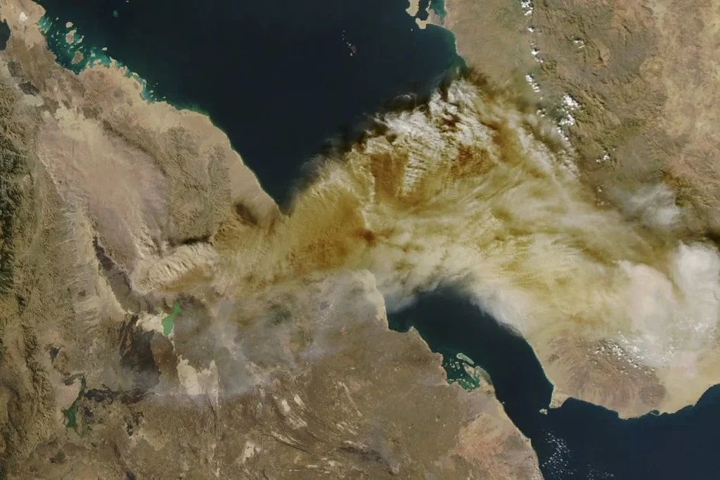
In the village of Afdera, on the southwestern shoulder of one of the hottest inhabited basins on Earth, Ahmed Abdela heard a loud sound and what he later described to the Associated Press as a shock wave passing through his body. “It felt like a sudden bomb had been thrown with smoke and ash,” he said. Fifty kilometres outside Semera, the regional capital, itself 190 kilometres south of Hayli Gubbi: the explosion was still audible. At the same instant, 08:30 Universal Time, Sunday, 23 November 2025, a planet-watching satellite belonging to the commercial firm Planet Labs happened to pass overhead. Its image, captured at 08:31 UTC and posted later that day by the volcanologist Simon Carn of Michigan Technological University, is the first photograph anyone has ever taken of an eruption at Hayli Gubbi.
“An explosive eruption of Hayli Gubbi volcano, located SE of Erta’Ale in the Afar Rift (Ethiopia), began at ~08:30 UTC on Nov 23,” Carn wrote on Bluesky that afternoon. “[…] Hayli Gubbi has no record of Holocene eruptions. Toulouse VAAC reporting ash to ~15 km.”
The volcano in question is unprepossessing. A low-profile shield rising barely 500 metres above the salt-pan floor of the Danakil Depression, Hayli Gubbi is the southernmost cone of the Erta Ale Range, a 150-kilometre line of basaltic vents that follows the rift axis in northern Ethiopia. Until that Sunday morning, the Smithsonian Institution’s Global Volcanism Program had recorded exactly one confirmed eruptive episode in the volcano’s history, dated to in or after 6250 BCE on the basis of lava flows that overlie 8,200-year-old lake sediments on the Giulietti Plain. The volcano had no instruments on it, no seismometers, no gas monitors, no permanent observers. It had a number, 221091 in the Smithsonian catalogue, and almost nothing else.
What followed was brief. The Toulouse Volcanic Ash Advisory Centre, the French meteorological agency that tracks volcanic plumes for the world’s aviation sector across Africa and southern Europe, declared the explosive phase ended by 20:00 UTC the same day. Visible activity had subsided altogether by 25 November. The plume, however, did not subside. By the time it dissipated a week later, it had crossed the Red Sea, the Arabian Peninsula, the Arabian Sea and the Indian subcontinent, reached western China, and disrupted air traffic from Kochi to Amsterdam. It had also become the largest stratospheric injection of sulfur dioxide from an East African volcano since Nabro in Eritrea fourteen years earlier.
Mohammed Seid, the local administrator who spoke to AP from Afdera, kept his account practical. “While no human lives and livestock have been lost so far, many villages have been covered in ash and as a result their animals have little to eat,” he told the agency. Tourists bound for the Danakil Desert, a draw for hardy travellers who come to see Erta Ale’s lava lake, were stranded in Afdera as ash blanketed the road. Abedella Mussa, the official in charge of health in the Afdera district, said two mobile medical teams had been dispatched to the affected kebeles of Fia and Nemma-Gubi. Residents were coughing. The district’s livestock official, Nuur Mussa, told AP that “many animals, especially in the two affected kebeles, cannot drink clean water or feed on grass because it is covered by volcanic ash.”
None of this would have surprised the small community of scientists who study the Afar rift. What surprised them was that it was Hayli Gubbi.
The Holocene silence
“First eruption in 12,000 years” is a phrase that has now appeared in several thousand headlines. It needs unpacking. Taken at face value, it suggests that geologists know, with confidence, that this particular volcano was inert for the entire span of human civilisation, from Göbekli Tepe through agriculture, writing, the printing press, electricity and the internet, and then chose 23 November 2025 to reawaken. The actual claim is more modest, and more interesting.
The phrase comes from the Global Volcanism Program’s database, which classifies the world’s roughly 1,400 Holocene-active volcanoes, Holocene being the current geological epoch, beginning at the end of the last ice age about 11,700 years ago. To make the database, a volcano has to have left evidence of an eruption since that date. Hayli Gubbi, until November, had not. Its only confirmed Holocene eruption, the one dated to in or after 6250 BCE, was inferred from a single stratigraphic relation: dark basaltic flows that lie on top of older lacustrine sediments dated to around 8,200 years before present, a relation first described by Roubet and colleagues in 1969 and reproduced in the Smithsonian database. After that, nothing, until last November.
This is not the same as saying the volcano did nothing. It is saying that nobody recorded anything. Hayli Gubbi sits in one of the most logistically forbidding stretches of Africa: salt flats below sea level, surface temperatures that routinely exceed 50 °C, sulfurous springs, no roads, no infrastructure, and until very recently no satellite coverage worth the name. Eruptions in such places do not enter the geological record unless either a human being writes them down, and the Afar floor has been sparsely populated by anyone capable of writing for most of the relevant interval, or satellites with synthetic aperture radar and ultraviolet spectrometers begin to detect their signatures from orbit. The first such satellites, with the spatial resolution and revisit frequency required to catch a remote eruption in near real time, did not begin operations until the early 2010s.
Juliet Biggs, the Earth scientist at the University of Bristol who co-directs the UK’s Centre for Observation and Modelling of Earthquakes, Volcanoes and Tectonics (COMET), put the caveat plainly to Stephanie Pappas at Scientific American. “I would be really surprised if [more than 12,000 years ago] really is the last eruption date,” she said. Recent satellite imagery, she noted, shows lava flows on the volcano’s flanks that look fresh, “probably less than a few hundred years old,” in the words of one specialist quoted by the New York Times. The Smithsonian’s own page, updated after the eruption, places the south-easternmost flows “sometime within the last 8,000 years, but no additional information about how recent they might be is known.”
That uncertainty is the point. “It really just shows how understudied this region is,” Biggs told Pappas. A volcano can be silent in the literature and active in the rock. The 12,000-year figure is a statement about what scientists have written down, not about what the volcano has done.
It also raises a question with implications well beyond Hayli Gubbi. The East African Rift System contains around 78 Holocene-active volcanoes, by the count of Fabien Albino and Juliet Biggs in their 2021 Sentinel-1 InSAR survey published in Geochemistry, Geophysics, Geosystems. Of those 78, only about a quarter have reported historical eruptions. The rest are, in the database sense, “dormant”, which in practice means “we have not seen them erupt yet.” Hayli Gubbi has just moved itself from one column into the other. There is no reason to assume it will be the last to do so this decade.
What the record actually constrains
The Holocene silence at Hayli Gubbi is constrained, principally, by three lines of evidence: surface mapping of lava flows and the sediments they overlie, satellite imagery of the volcano’s geomorphology, and the absence of any contemporary report of activity in the historical record. Each is weaker than it sounds. The mapping by Barberi and Varet, the Italian geologists who produced the first systematic description of the Erta Ale range in 1970, identified Hayli Gubbi as a young shield but did not produce radiometric ages for the youngest surface flows. The eight-thousand-year-BP date refers to the sediments under the flows, not the flows themselves. The flows could be substantially younger.
Satellite imagery captures the morphology but not the chronology. The high-resolution imagery now used to map fresh flows, distinguishing them by reflectance, by lack of dust cover, by the angularity of their margins, has only been available at this quality for the last decade or two. A flow erupted in, say, the 1500s would, by now, look indistinguishable from one erupted in the 500s. And the historical record in this part of Africa is thin. The Ethiopian highlands have produced written chronicles for two millennia, but those chronicles are highlands documents: they describe the affairs of Christian kingdoms several hundred kilometres west, on the cool plateau, not the activities of nomadic Afar pastoralists in the salt desert. An eruption in the Danakil could have been seen by a handful of camel herders, integrated into oral tradition, and never reach a literate observer who would write it down.
The result is a record full of holes. Hayli Gubbi may have erupted in the 1700s, the 1300s, the year 200, at any point, and left no published trace. Biggs’s professional caution about the 12,000-year figure is not a hedge. It is an accurate description of what we know.
The triple junction underneath
To understand why a forgotten shield volcano in northern Ethiopia matters to anyone outside the Afar region, you have to look down, about fifteen kilometres straight down, which is roughly all the crust there is beneath Erta Ale, the thinnest crust anywhere in the Afar rift, as imaged by seismic refraction work going back to Makris and Ginzburg in 1987.
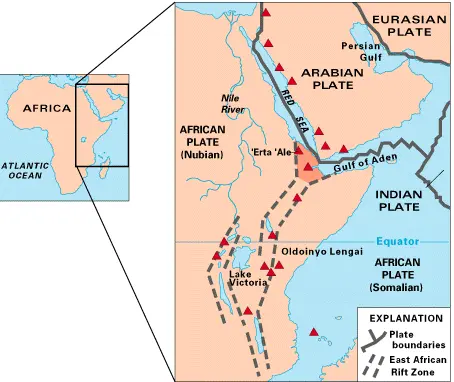
Beneath the Afar Depression, a triangular basin of about 200,000 square kilometres, bounded by the Ethiopian and Somalian plateaux to the west and southeast and by the Danakil Block to the northeast, three rift arms meet. The Red Sea Rift comes in from the north. The Gulf of Aden Rift comes in from the east. The East African Rift‘s northern, Ethiopian arm comes in from the south. The geometry is what plate tectonicists call a ridge–ridge–ridge triple junction, of the type first formalised by Dan McKenzie and Jason Morgan in 1969. It is the only such junction on Earth currently above sea level, and the only place where the transition from continental rifting to true sea-floor spreading can be observed without a research vessel.
The plates pulling apart are the Nubian Plate to the west, the Somalian Plate to the south, and the Arabian Plate to the northeast. Wedged among them, like a fragment caught in a slowly opening drawer, is the Danakil microplate, a rigid block of crust that has been rotating anticlockwise relative to Nubia for at least eleven million years, with a marked eastward acceleration since the late Pliocene as oceanic-style accretion began within Afar itself. The kinematic reconstruction by Eagles and colleagues in 2002, published in Earth and Planetary Science Letters, traced the microplate’s rotation through magnetic chron C5 to its present position and tied its acceleration eastward to the onset of oceanic-style accretion within Afar itself. The Danakil’s drift created a window in Africa’s continental crust. Through that window, magma has been rising for the better part of 30 million years.
The numbers vary by location. The total divergence rate between Nubia and Arabia, integrated across all three rift arms, is on the order of 16 millimetres a year. At the latitude of Erta Ale itself, GPS-constrained models give about 14 millimetres a year of opening, increasing southward from roughly 6 millimetres at latitude 15° N to 14 millimetres at 13.5° N, per Viltres and colleagues’ 2020 study using continuous GPS networks across the Red Sea region. Arianna Soldati, a volcanologist at North Carolina State University, summarised the local figure for Scientific American as “about 0.4 to 0.6 inches a year”, between 10 and 15 millimetres, which is the rough range for the rift segment that runs through the Erta Ale magmatic chain.
This is slow. A fingernail grows faster. But integrated over geological time, it is enough to thin the continental crust beneath the Afar floor to roughly 15 kilometres, allow the asthenosphere to rise close to the surface, and produce the parade of basaltic shield volcanoes, Dallol, Gada Ale, Alu-Dalafilla, Bora Ale, Erta Ale and Hayli Gubbi, that defines what specialists call the Erta Ale magmatic segment. Most of the time, this segment accommodates plate divergence not by visible earthquakes on the surface but by intruding dikes: vertical sheets of basaltic magma that open the crust like wedges driven into a log. The 2005 Dabbahu rifting episode further south, when a 60-kilometre dike opened in a single fortnight and produced an estimated 2.5 cubic kilometres of intruded magma, remains the canonical modern example. It also produced a sequence of thirteen further dike intrusions over the following five years, none of which fed surface eruptions of comparable scale to the first. The July 2025 dike from Erta Ale’s North Caldera, as it turned out, was the next major event of this kind in the rift.
A continent breaking up in slow motion
It is worth holding the time scale steady. The Atlantic Ocean opened over roughly 200 million years. The Red Sea has been opening for about 30. The East African Rift, in its present configuration, is perhaps 25 million years old. By the standards of the planet, the Afar triple junction is young, but the process it represents has happened before and will happen again. Emma Watts and colleagues, writing in Nature Geoscience in 2025, used geochemical data from more than 130 samples of young volcanoes across the three rifts to argue that the underlying mantle constitutes a single, asymmetric upwelling, supporting the long-standing view that a plume-like source, the “Afar plume”, has been feeding melt into the system for tens of millions of years.
The implication is that what is happening at Hayli Gubbi is not anomalous. It is a routine event in the protracted business of breaking Africa in two, an event whose anomalous appearance is largely a function of human attention. The rift accommodated about 16 millimetres of opening last year. It will accommodate roughly the same this year. Some of that opening will be aseismic, in the form of slow creep on subterranean faults; some will arrive in discrete pulses, as dikes and eruptions of varying magnitude. The cost of all this geology, for the people who live on top of it, is that East African volcanism is monitored at a fraction of the intensity of its Italian or Icelandic counterparts. Albino and Biggs’s 2021 survey found that around 20 per cent of the 78 Holocene volcanoes along the rift were deforming during a five-year window, uplift, subsidence, or post-eruptive readjustment, and yet only a handful had any ground-based instruments. Hayli Gubbi, until 23 November, had none.
Erta Ale lit the fuse
Twelve kilometres north-northwest of the Hayli Gubbi summit, the basaltic shield of Erta Ale rises 600 metres from the basin floor and hosts what is, by most counts, the longest-lived lava lake on the planet. The Southern Caldera lake has been continuously active since at least 1906, when European explorers first reliably described it. The Northern Caldera contains a transient lake that intermittently overflows. Erta Ale’s persistent lava lake is the reason a small but devoted stream of tourists makes its way each year to Afdera and then north across the salt pans on the back of a four-wheel drive or, more commonly, a camel.
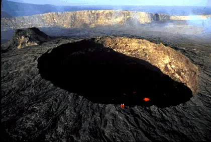
On 15 July 2025, after several weeks of unusual fountaining and crater-floor restlessness, Erta Ale erupted. The event was visible from orbit within hours. Optical sensors from the Copernicus Sentinel-2 platform recorded caldera collapse, explosions and lava flows from fissure vents that opened both inside the Southern Caldera and along the rift to the southeast. Within days, a second cluster of vents had opened only two kilometres from Hayli Gubbi’s crater. The lava lake itself drained: no lake was observed in the pit craters after 18 July, and Sentinel-1 detected centimetric uplift across the surrounding region between 21 July and 3 August, the geophysical signature of magma intruding shallowly beneath the rift floor.
The full reconstruction of what happened beneath the surface came in late 2025, in a paper published in Frontiers in Earth Science (DOI 10.3389/feart.2025.1719687) by Alessandro La Rosa of the University of Pisa and colleagues from Addis Ababa University, the University of Southampton, the GFZ Helmholtz Centre in Potsdam and South China Agricultural University in Guangzhou. Using a combination of interferometric synthetic aperture radar, optical pixel-offset tracking and local seismicity, they reconstructed the geometry of a single magmatic event spanning 25 days. A dike, a near-vertical blade of magma several metres thick, had propagated southwards from Erta Ale’s North Caldera for 36 kilometres, slicing through the basalt of the rift floor and intruding, by their corrected estimate, around 0.4 cubic kilometres of mafic magma. A correction issued in January 2026 (DOI 10.3389/feart.2025.1759997) raised the figure to ~0.4 km³ after a tabulation error in the supplementary tables, specifically Supplementary Table S2, where the volumes for two sources, SP and D2, were reported incorrectly.
“During 25 days, a dike propagated southward for 36 km, intruding a total of ∼0.4 km³ of mafic magma,” La Rosa and colleagues wrote in the corrected abstract. The InSAR modelling resolved the plumbing in more detail than any previous Afar event. The dike was fed from at least three distinct magma bodies: a deep source at roughly seven kilometres depth that supplied the initial intrusion, and two shallow sills at about one kilometre depth that fed its later stages. The geometry implies a long-lived, multi-level magma storage system beneath the Erta Ale ridge, with reservoirs at different crustal levels exchanging melt over years and decades rather than centuries. It is consistent with what Carolina Pagli and colleagues, including several of the same authors, had inferred from earlier dikes at Dabbahu in 2005, Manda Hararo in 2008–2010 and Erta Ale in 2017–2019: a stacked system of interconnected sills, fed from below by a plume-derived source, with individual intrusions tapping whichever reservoir is most pressurised at the moment.
The dike’s southward terminus, in the La Rosa et al. model, passes directly beneath Hayli Gubbi and continues a further distance into the Afrera Plain. The southernmost fissure vents observed in mid-July sat within two kilometres of the volcano’s existing summit crater. From 25 July onwards, an anomalous white plume appeared inside the summit crater itself, persisting in satellite imagery through at least 18 November, almost four months of low-level degassing, visible on virtually every Sentinel-2 pass. COMET’s event response reports, authored by Edna Dualeh, Lin Way and Biggs in Bristol with collaborators at Leeds, Manchester, IPGP and Addis Ababa, flagged the precursors but could not say where, if anywhere, magma would breach.
The connection between Erta Ale’s caldera collapse on 15 July and Hayli Gubbi’s explosion on 23 November is, on present evidence, causal but not simple. Magma intruded laterally from one volcanic system, came to rest at shallow depth beneath a different volcanic edifice 12 kilometres away, and then, four months later, broke the surface there, in a style of eruption neither volcano had produced in recorded history. The 36-kilometre dike is not the longest ever documented in the rift; Dabbahu was longer. But it is among the largest by intruded volume, and the only one yet observed to have fed an eruption at a previously dormant centre at its distal end.
The dike as bridge
What La Rosa’s reconstruction makes possible is a new kind of question. If a single dike can extend laterally for 36 kilometres along a magmatic segment, and if its emplacement can pressurise dormant edifices at its tip into eruption, then the relevant unit for forecasting is not the individual volcano but the segment. Erta Ale and Hayli Gubbi are not separate hazards. They are nodes on a shared plumbing system, and an unrest signal at one is a forecast signal at the other.
This is not a new idea. The Krafla rifting episode in Iceland in 1975–1984 produced nine separate eruptions over nine years, fed from a connected shallow reservoir system under the Krafla caldera but breaking the surface at different points along the fissure swarm. The Manda Hararo–Dabbahu rifting in Afar between 2005 and 2010 worked similarly: one chamber, fourteen dikes, multiple surface eruptions at different locations. What La Rosa’s paper does is bring the same framework to the Erta Ale segment, with quantitative geometry. The next eruption in this segment may not be at Erta Ale or Hayli Gubbi. It may be at Gada Ale, or Alu-Dalafilla, or at a vent that has no name in the database, but if it happens, it will most likely happen because the same multi-level reservoir found another exit.
Why a shield volcano built an umbrella cloud
If the dike explains how magma got beneath Hayli Gubbi, it does not explain what happened on 23 November. Shield volcanoes, broad, low-profile structures built up by repeated effusion of fluid basalt, are not supposed to do this. The textbook example is Mauna Loa in Hawai’i, which oozes lava rather than throwing it. When shield volcanoes do erupt explosively, the usual cause is something other than the magma itself.
“To see a big eruption column, like a big umbrella cloud, is really rare in this area,” Biggs told Scientific American. The phrase “umbrella cloud” is technical: it describes the laterally spreading top of a sustained eruption column that has reached its neutral buoyancy height and stalled out horizontally, like a thunderhead. The Hayli Gubbi plume, by the time NASA’s Aqua satellite caught it four hours after the eruption began, was a near-textbook umbrella, with a high arm drifting east-northeast under the subtropical jet and a lower, lobate arm spreading north along the ground. The Toulouse VAAC classified the event as sub-Plinian, the second-highest tier of explosive eruption style, characterised by sustained columns reaching the upper troposphere and widespread fine ash deposition.
For a basaltic shield, two ingredients can produce this kind of column. The first is composition. Although Hayli Gubbi is built mainly of basalt, the Smithsonian’s geological summary notes the presence of trachyte and rhyolite, significantly more silica-rich, more viscous, more gas-retentive magmas, in older deposits at the summit. If a basaltic intrusion arrived beneath a body of evolved silicic magma stored shallowly in the edifice, the result could be precisely the kind of sub-Plinian column observed: silicic magma flushed out by mafic recharge, with explosive fragmentation driven by exsolving volatiles. The bimodal basalt–rhyolite association is common in continental rift volcanoes; in the Afar, similar evolved magmas have been documented at Alu-Dalafilla and Dallol.
The second ingredient is water. The Danakil floor is below sea level. It hosts brines, salt-saturated aquifers and, in places, active hot springs. If rising magma encountered groundwater or evaporite-hosted brine at shallow depth, the result would be phreatomagmatism, explosive fragmentation driven not by magmatic gas but by the violent flashing of water to steam. Phreatic and phreatomagmatic eruptions are characteristically short, characteristically violent, and characteristically capable of generating ash columns far taller than the underlying magma would produce on its own. The most famous example is Surtsey, off Iceland, where seawater meeting basaltic magma in 1963 produced an island and an eruption style, Surtseyan, that has its own entry in the textbooks.
The field evidence available so far points toward steam. On 25 November, a Danakil expedition group led by Osman of Sora Tours Ethiopia, which had been camped at Erta Ale during the eruption, walked across the salt to within a few hundred metres of the Hayli Gubbi crater rim. Their report, posted by VolcanoDiscovery, described intense steaming and degassing from the new vents, but no fresh lava and no fluidised lava bombs. They documented massive volcanic blocks, some estimated at 100 kilograms, thrown more than 50 metres from the crater; medium to smaller projectiles scattered over a wider radius; and a thick carpet of fresh, dark-brownish ash. The fumes made it impossible to approach closer than a few hundred metres. The volcanologists writing for VolcanoDiscovery, on the basis of those observations and the eruption’s short duration, suggested the event might have been “a phreatic explosion, caused by overheated water in the underground flashing to steam, which in turn could have been caused by a rising magma body which itself has not yet arrived at the surface.”
If that interpretation holds, the implication is significant. A phreatic eruption is not a magmatic eruption. It is a pressure-release event, in which heat, but not necessarily new molten rock, reaches the surface. The fresh magma intruded from Erta Ale during July and August may still be sitting at shallow depth beneath Hayli Gubbi, unerupted, retaining its heat and its potential. The summit clearance on 23 November may be the opening act of a longer sequence, not the closing act of a brief one.
That preliminary reading is consistent with what Derek Keir, the University of Southampton Earth scientist who happened to be in Ethiopia when the eruption began, will be able to test. On Monday 24 November, Keir collected ash samples in the field, work Biggs told Scientific American would reveal “what kind of magma caused the eruption.” If the new ash contains juvenile mafic glass, the dike from Erta Ale fed it directly. If it contains a high proportion of evolved silicic shards, an older trachyte–rhyolite reservoir was tapped. If it is dominated by lithic fragments, broken bits of country rock with little juvenile component, the eruption was driven mostly by steam, with the magma itself still at depth. The petrology will be definitive. The samples are now in laboratories at Southampton, Pisa and Addis Ababa; results will follow in the coming months.
Arianna Soldati framed the broader principle for Scientific American in a sentence worth keeping. “So long as there are still the conditions for magma to form, a volcano can still have an eruption, even if it hasn’t had one in 1,000 years, 10,000 years,” she said. Dormancy, in volcanology, is not the same as extinction. It is a probability statement, and the probabilities are estimated from a record that, for places like the Afar floor, is barely a century deep.
The plume that crossed continents
From the moment the explosive phase began at 08:30 UTC, the Hayli Gubbi plume was moving east. The subtropical jet at the time was running close to its climatological position over the northern Arabian Sea, with wind speeds of 100 to 120 kilometres per hour at altitudes between 15,000 and 45,000 feet. The plume’s higher arm fed straight into it. By the time Simon Carn’s first TROPOMI measurement was taken around 11:00 UTC, two and a half hours after the eruption began, the visible SO₂ filament had already detached from the source and was spreading east, carrying about 44 kilotonnes (0.04 teragrams) of sulfur dioxide. That number is the early one. It is not the total.
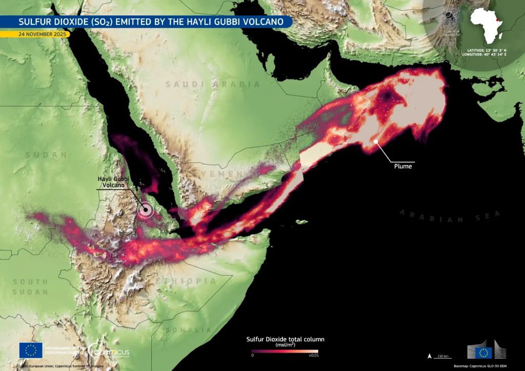
Over the following 48 hours, the SO₂ mass detected by TROPOMI climbed. The German Aerospace Center’s INPULS project, which combines Sentinel-5P retrievals with atmospheric chemistry modelling, reported peak detected mass of around 160 kilotonnes by mid-week. Smithsonian’s Global Volcanism Program, integrating across satellite passes and accounting for plume dispersion, settled on a total released SO₂ load of approximately 0.2 teragrams, about 220,000 tonnes, released between 08:30 and roughly 20:00 UTC on 23 November. Independent retrievals from IASI on the Metop satellites placed most of the SO₂ between 12 and 15 kilometres altitude, straddling the tropopause at that latitude and feeding part of the burden directly into the lower stratosphere.
A 0.2-teragram SO₂ injection is significant but not climatically large. By comparison, the June 1991 eruption of Mount Pinatubo released approximately 20 million tonnes of SO₂, about a hundred times more, as measured by the TOMS satellite and reported by Bluth and colleagues in Geophysical Research Letters in 1992. That eruption produced Northern Hemisphere surface cooling of up to 0.5 to 0.6 °C and global cooling of perhaps as large as 0.4 °C over large parts of the Earth in 1992–93, per Self and colleagues in the USGS Fire and Mud volume. The closest East African comparator is the 2011 Nabro eruption in Eritrea, which released approximately 1.5 teragrams of SO₂, roughly seven times the Hayli Gubbi load (Clarisse and others, 2012; identified by Bourassa and others, 2013 as the largest SO₂ emitter of the 2002–2012 interval), and produced a measurable but short-lived perturbation of stratospheric aerosol over Asia. The Hayli Gubbi plume is unlikely to register in global temperature records. It is, however, large enough to be tracked from orbit for weeks, and to provide a clean tracer experiment for atmospheric scientists studying long-range transport in the subtropical jet.
The first country downwind was Yemen. By 00:57 UTC on 24 November, the Toulouse VAAC reported a substantial ash-and-SO₂ cloud over Yemen and Oman. By 10:58, the plume had reached the airspace between Oman and Pakistan, moving east-northeast at altitudes between 25,000 and 45,000 feet. By 17:00, a broad ash cloud was spreading east across southern Pakistan and northeastern India. By 23:00, the plume was over Delhi, 4,130 kilometres from the source, and moving fast toward China. Himawari-8 imagery captured its passage across Nepal and Tibet through the day on 24 November.
The aviation consequences
The aviation effects followed. India’s Directorate General of Civil Aviation, the country’s flight regulator, issued an ASHTAM advisory on the evening of 24 November telling carriers to avoid published volcanic-ash-affected areas and flight levels and to conduct post-flight engine borescope inspections on aircraft that had operated through suspect airspace. According to Gulf News reporting on 25 November, seven international flights were cancelled and twelve others delayed on Tuesday as the ash passed through Indian airspace. Air India, IndiGo, Akasa Air, KLM and SpiceJet all cancelled, diverted or issued advisories on Indian Gulf and European long-haul rotations through 24 and 25 November, with the heaviest disruption on Kochi-Dubai, Kochi-Jeddah, Kannur-Abu Dhabi and Amsterdam-Delhi services.
The reason for the caution is not historical. In 1982, a British Airways 747, Flight 009, lost all four engines after flying through an undetected ash cloud from Mount Galunggung in Indonesia. The pilots restarted the engines (although engine number 2 started vibrating and the crew had to shut it down soon after), allowing the aircraft to land safely on three engines at Halim Perdanakusuma International Airport in Jakarta. In 1989, a KLM 747 lost all four engines flying through the ash from Mount Redoubt in Alaska, restarted them, and landed at Anchorage. After the 2010 eruption of Eyjafjallajökull paralysed European airspace for six days, Eurocontrol coordinated closures from 15 to 21 April 2010, in what was widely described at the time as the largest closure of European airspace since the Second World War, the International Civil Aviation Organization tightened its volcanic-ash framework.
The nine Volcanic Ash Advisory Centres now operate continuously in Toulouse, London, Anchorage, Washington, Buenos Aires, Darwin, Wellington, Tokyo and Montreal. The Toulouse VAAC’s first advisory for Hayli Gubbi was issued at 08:42 UTC on 23 November, within twelve minutes of the eruption’s onset. That response time is the product of fifteen years of investment in geostationary monitoring and automated ash-detection algorithms; it is also the kind of capability that does not yet exist in most parts of Africa for any other natural hazard. Volcanic ash advisories exist because, after Galunggung, the global aviation industry decided they had to. They are, in effect, the first piece of natural-hazard infrastructure to be built around the rift, even though the rift was not the reason they were built.
By 25 November, the ash had cleared Indian airspace. By 1 December, the SO₂ signal was still detectable from orbit over the western Pacific. The plume’s eastward leakage into the lower stratosphere will be tracked, by TROPOMI and IASI, for months. Hayli Gubbi’s signature on the global atmospheric record will outlast its eruption by a wide margin.
What comes next
By 25 November, the eruption was effectively over. By 26 November, expedition photographs and Sentinel-2 imagery revealed the new shape of the volcano. The original summit crater, around 330 metres across, had been enlarged to roughly 390 metres on its north-south axis and 360 on its east-west. About a hundred metres east-southeast of the main crater, a new vent had opened, roughly 255 metres across, and immediately south of that, a third smaller crater of about 110 metres. Ash mantled the older flows to the north, northeast and east. White plumes still rose from the main crater on 25 November and have continued, at low intensity, into early 2026.
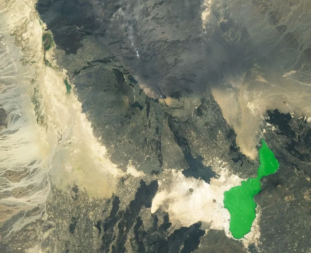
The geophysics is not finished. La Rosa and colleagues note that a dike of 0.4 cubic kilometres has injected roughly half its volume into shallow storage that has not yet erupted. Some of that magma may freeze in place, contributing to the long-term thickening of the rift’s mafic lower crust. Some may continue to evolve, find a path to the surface, and erupt elsewhere along the segment in the coming months or years. Atalay Ayele, head of seismology at Addis Ababa University and one of the few Ethiopian scientists with deep institutional memory of the rift’s behaviour, told the Associated Press that the rift is “an active area” and that monitoring would continue. “This is the first recorded eruption of Hayli Gubbi in the last 10,000 years,” he said, a sentence that, given the constraints on the record, is also the most honest one.
A baseline emerges
What the rift now has is the beginning of a baseline. NASA’s MODIS instruments captured the plume; Sentinel-5P’s TROPOMI quantified the SO₂; Sentinel-2’s optical channels mapped the new craters; Sentinel-1’s synthetic aperture radar resolved the dike; COMET’s LiCSAR pipeline at the Universities of Leeds and Bristol produced interferograms within days. The German Aerospace Center’s INPULS project, which builds higher-level products on top of Sentinel-5P retrievals, is now generating multi-day animations of the SO₂ cloud. The new Meteosat Third Generation Sounder, MTG-S, captured the eruption with its Infrared Sounder while still in its early commissioning phase, its first operational test on a major eruption. Within ten days of the eruption, three independent research papers had been submitted to peer-reviewed journals, including the La Rosa et al. dike paper, an atmospheric transport study using HYSPLIT trajectories led by Indian groups using Sentinel-5P data, and a Scientific Reports paper by Murakami and Tanaka analysing internal gravity waves embedded in the plume as imaged by Himawari-8 and Meteosat-9.
This is what a modern volcanic baseline looks like. The architecture is satellite-first because the rift permits very little else, multi-agency because no single national programme could afford to build the constellation it relies on, and fundamentally reactive: instruments designed for global monitoring captured Hayli Gubbi because they were already there, not because anyone had targeted the volcano. The whole apparatus came together inside 48 hours because the apparatus exists.
Where the gaps are
The lesson is not that East Africa needs more satellites. The constellation is good. The lesson is that East Africa needs more ground stations, more seismic arrays, more permanent gas monitors, more capacity for the universities in Addis Ababa, Asmara, Nairobi and Dar es Salaam to lead the science of their own continent. Albino and Biggs’s 2021 InSAR survey detected 18 distinct deformation signals on 14 of the rift’s 78 Holocene volcanoes during a five-year window. Each of those is a small Hayli Gubbi waiting to happen, or, just as likely, a small Hayli Gubbi quietly choosing not to. Without ground-based observations, the satellite signals cannot be inverted into eruption forecasts. They can only be inverted into hindcasts, of the kind COMET and the Universities of Pisa and Southampton produced in November 2025: rigorous, beautiful, and several months too late to warn anyone.
There are obvious candidates for closer attention. Alu-Dalafilla, 25 kilometres north of Erta Ale, last erupted in 2008; its shallow magma chamber is well-imaged. Dallol, at the northern end of the segment, has been subsiding for years over a deflating sill at 1.5 kilometres depth, as Kebede and colleagues showed in 2025. Manda Hararo, the centre of the 2005–2010 dike sequence, has been quiet but is unlikely to remain so indefinitely. Each of these volcanoes has the kind of multi-decade history that, in Italy or Iceland or Hawai’i, would have produced a permanent observatory. None of them, currently, has one.
For the people of Afdera, the practical questions are smaller. Will the ash continue to fall? Will the grass come back? Will the water be drinkable? Mohammed Seid’s villages were lucky: the eruption was brief and the ash was light. Had the explosive phase lasted three days instead of twelve hours, the answers would have been worse. Had a pyroclastic density current, and the Smithsonian’s weekly report noted features in the satellite imagery that may indicate dilute PDCs travelling 130 kilometres north, passed through inhabited terrain, the answers would have been catastrophic. The rift was generous this time. It will not always be.
The morning of 23 November, in Afdera, Ahmed Abdela heard what he thought was a bomb. It was the rift speaking, as it has been for thirty million years. The only thing different about last November is that, this time, the planet was listening.