A hole that should not exist
In mid-July 2014, helicopter crews flying over the central Yamal Peninsula in northern Russia spotted a near-perfect cylinder punched into the flat tundra, about 30 kilometres southeast of the Bovanenkovo gas field. Reindeer herders had reported a column of smoke and a flash in the same region months earlier. When a team led by Andrei Plekhanov of the Scientific Research Centre of the Arctic in Salekhard reached the site, they found a shaft roughly 20 metres across, ringed by a low rampart of frozen blocks that had been thrown clear of the rim. The walls in the lower half stood vertical, as if bored by a machine. The maximum depth measured on 16 July 2014 was 52 metres, deeper than a 15-storey building is tall.
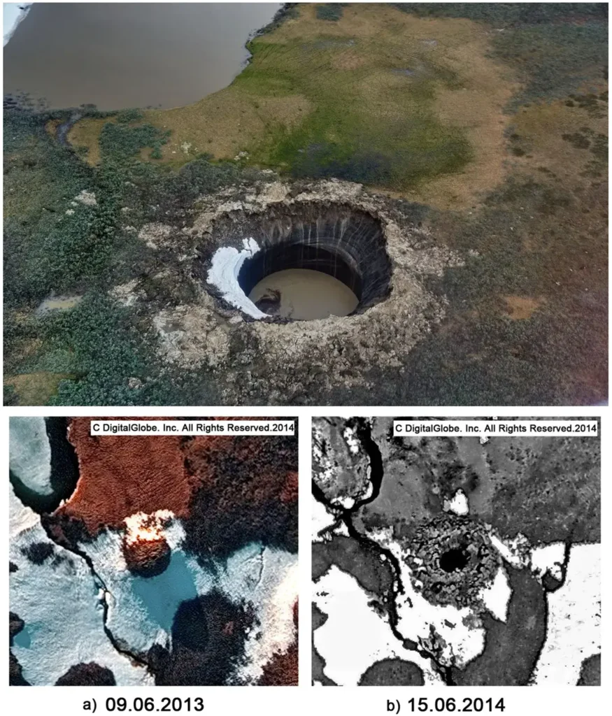
The crater sits at N69.970965 E68.369575. It has carried several names in the literature: the Yamal crater, B1, C1, and GEC-1. Inside, instruments recorded methane concentrations that reached 9.6 to 9.8 percent of the air directly in the crater, against a normal atmospheric background near 0.0002 percent. Early visitors floated explanations that ranged from a meteorite strike to a stray missile to the collapse of a buried gas facility. A spokesperson for the regional Emergencies Ministry ruled out a meteorite within days.
More than a decade later, the broad outline is settled. The Yamal crater belongs to a class of features now called gas emission craters, or GECs, and they form when gas trapped under or within the permafrost builds enough pressure to blow the frozen ground out of its own roof. What remains unsettled, and sharply contested, is the exact plumbing: where the gas comes from, what builds the pressure, and why these holes appear on the Yamal and Gydan peninsulas and nowhere else in the circumpolar Arctic. Three research teams have published competing answers, and none has closed the case.
Not the same wound as Batagay
Siberia hosts more than one kind of dramatic permafrost feature, and the gas craters are easily confused with another. The Batagay megaslump in Yakutia is a thaw scar that widens gradually as ice-rich ground melts and slumps backward, growing across years and decades into a kilometre-long amphitheatre. The gas emission craters work on a different clock and by a different force. They open in seconds to days, driven by gas pressure instead of slow surface melt, and they leave a steep cylindrical pipe, not a retreating headwall. A megaslump erodes. A gas crater detonates.
That distinction matters for what each feature can tell us. The slump records the speed of thaw. The crater records a buried reservoir of pressurized gas and the strength of the frozen lid that held it.
The anatomy of a gas emission crater
The craters share a recognizable life cycle that satellite imagery has captured across several sites. Before the explosion, a mound grows at the surface, a swelling up to about 6 metres high and 20 to 55 metres wide. At the Yamal crater, high-resolution imagery from 2012 and 2013 shows a mound roughly 8 metres tall standing where the hole later opened. These mounds resemble pingos, the ice-cored hills common to Arctic landscapes, but the GEC precursors are pushed up by pressurized fluid and gas, not by the growth of an ice core alone.
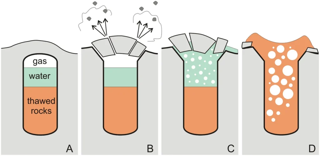
Then the ground fails. The cap fractures, gas and debris accelerate outward, and blocks of frozen soil and ground ice are flung clear. At the Yamal crater, ejected fragments were found scattered out to roughly 120 metres, and the parapet of thrown material around the rim stood up to 3.2 metres high. Geochemical work by Sergey Vorobyev and colleagues at Lomonosov Moscow State University, with Evgeny Chuvilin of the Skolkovo Institute of Science and Technology, estimated that the former talik, the body of frozen ground that fed the system, amounted to about 220,000 cubic metres.
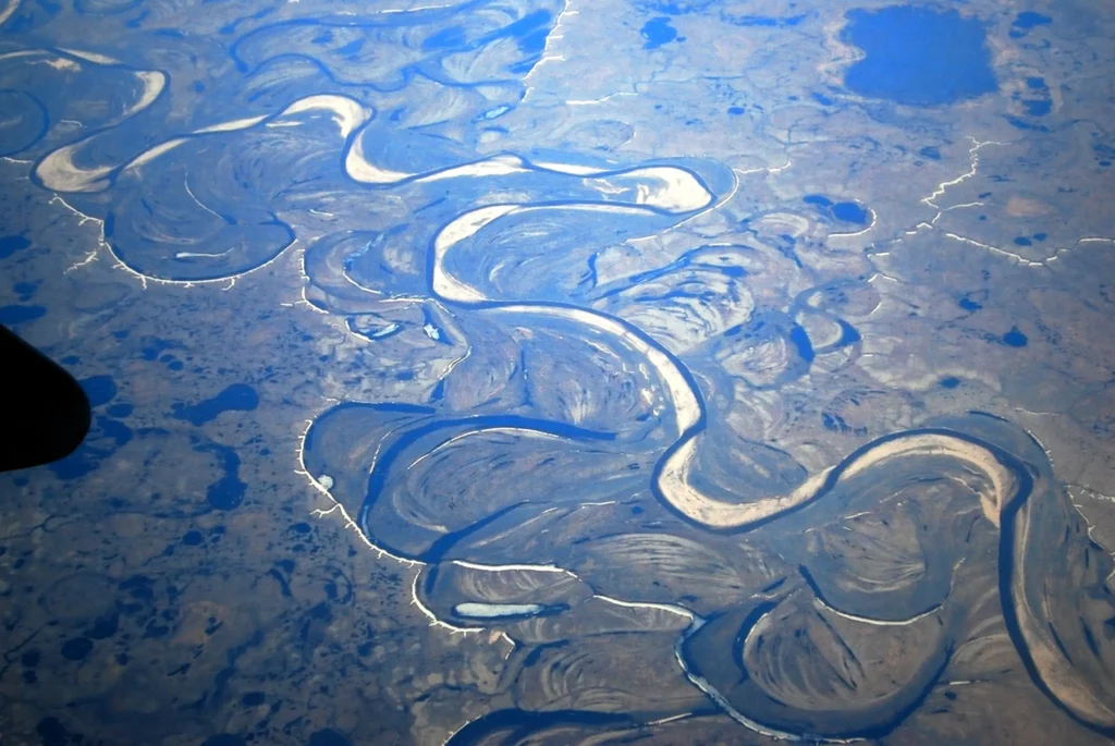
The hole does not stay a hole. Meltwater, rain, and collapsing sediment fill it quickly. Yury Dvornikov and colleagues tracked two craters, GEC-1 and AntGEC near the Gydan settlement of Antipayuta, from initial depths of 50 to 70 metres and 15 to 19 metres down to lakes only 3 to 5 metres deep within three years. Within a few seasons a fresh crater becomes a round, turbid pond that is hard to distinguish from the ordinary thaw lakes dotting the tundra. That rapid disguise is central to one of the open questions about how many of these features exist.
Why only here
The craters cluster in one of the most gas-rich regions on Earth. The Yamal and Gydan peninsulas sit atop the West Siberian hydrocarbon province, which the U.S. Geological Survey’s Circum-Arctic Resource Appraisal describes as “the largest petroleum basin in the world,” with “an areal extent of about 2.2 million square kilometers.” Evaluated gas reserves at the Yamal Peninsula and its adjacent offshore areas come to about 26.5 trillion cubic metres. The Bovanenkovo field alone feeds trunklines with an aggregate design capacity of 115 billion cubic metres of gas a year toward European markets.
Permafrost here is continuous and thick, reaching as much as 500 metres in places, and it acts as a seal over the gas below. The same region also carries a notable heat anomaly in the ground and a network of faults that can channel fluids and warmth upward. The Yamal crater formed in ice-rich permafrost with mean annual ground temperatures of −1 to −5 degrees Celsius and a bulk ice content of 30 to 65 percent by volume.
This combination is what makes the location puzzling rather than obvious. Cryopegs, ground ice, and methane hydrate are all common across Arctic permafrost, yet the explosive craters are confined to these two peninsulas. Any successful model has to explain not just the explosion but the geography.
Three teams, three mechanisms
The disagreement is active and unresolved. The competing models do not differ over whether gas pressure drives the blast, which all accept. They differ over what fills the reservoir and builds the pressure, and how deep the answer lies.
The cryovolcanic model: pressure from freezing
In 2018, Sergey Buldovicz and a team from Lomonosov Moscow State University published the first detailed mechanism in Scientific Reports, framing the Yamal crater as a case of cryovolcanism, a process previously discussed mainly for icy moons such as Triton and Enceladus. In their account, the crater formed where a thaw lake shrank and dried, exposing the ground beneath to refreezing. As the unfrozen pocket below the former lake, a talik, froze inward from all sides, gas and dissolved carbon dioxide were squeezed into a shrinking volume of wet ground. The pressure climbed until it exceeded the strength of the overlying frozen cap, and the pingo that had grown over the talik blew out. The cylindrical shape of the crater, they argued, traced the cylindrical shape of the remnant unfrozen core.
The geochemistry supported a shallow, local origin for the gas. The carbon isotope signature of methane near the crater was about −76 per mil, typical of biogenic gas produced by microbes in the ground rather than deep thermogenic gas from the hydrocarbon reservoirs. A 2019 geochemical study by Vorobyev and colleagues reinforced this, identifying the permafrost at the site as the remains of a sub-lake paleo-talik from which gas and mineralized water had been expelled.
The osmosis model: pressure from a salty lens
In 2024, a team centred at the University of Cambridge proposed a different driver. Ana Morgado, a chemical engineer, with Luis Rocha, Julyan Cartwright, and Silvana Cardoso, published in Geophysical Research Letters a model built around the cryopeg, a lens of salty, unfrozen water trapped within the permafrost. On the Yamal Peninsula such cryopegs sit below about 50 metres depth, just above a layer of metastable methane hydrate. They are brines of sodium chloride at 7 to 150 grams per litre, typically 0.5 to 12 metres thick and extending up to 300 metres across.
The salt is the engine. As the active surface layer thaws more deeply under a warming climate, meltwater migrates downward along grain boundaries, pulled by the osmotic gradient between fresh surface water and the briny cryopeg. The cryopeg cannot hold the added water, so pressure builds. Eventually the overlying soil cracks, the cracks propagate to the surface, and the pressure at depth drops suddenly. That drop destabilizes the methane hydrate beneath, which dissociates and releases gas in a physical explosion. Morgado’s team calculates that the buildup can take decades, a timescale that fits the onset of strong Arctic warming since the 1980s. Morgado has described the required setting as “very, very niche, very precise.”
Not everyone is convinced. Chuvilin called the hypothesis novel but questioned whether meltwater can reach the cryopeg at all, noting that the cryopeg lies far from the surface and that the permeability of the icy ground is very low. A separate published commentary argued the model needs to account for how salinity lowers the freezing point and for the kinetics of cryopeg expansion and hydrate dissociation.
The deep-fault model: pressure and heat from below
The most recent entry came in 2025, when Helge Hellevang, an environmental geoscientist at the University of Oslo, with Mats Ippach, Sebastian Westermann, and Mohammad Nooraiepour, published in Science of the Total Environment. Their model pushes the source deeper. Discrete conductive faults, they argue, bring natural gas and heat up from the West Siberian hydrocarbon province to the base of the permafrost, where the heat deforms and melts the frozen base from below and the gas accumulates in domal traps. Climate warming thins the permafrost from above at the same time. Where the seal grows thin enough, the trapped gas blows it out.
Hellevang’s central claim is that the permafrost by itself does not hold enough methane to drive blasts of the observed size, so the gas must come from the deep reserves. The model is built to answer the geography question directly. Hellevang told New Scientist that climate change “is likely the triggering factor, but it happens there because you have the thinning of the permafrost due to the gas.” His team concludes that focused deep heat and gas from below the permafrost is the key factor, with atmospheric heating acting only as an indirect trigger. The work was first posted as an EarthArXiv preprint and is presented by its authors as a conceptual model awaiting fieldwork and simulation.
What the physics allows
One quantitative result cuts across the debate. Lauren Schurmeier, a geophysicist at the University of Hawaiʻi at Mānoa, with Gwendolyn Brouwer and Sarah Fagents, tested in 2024 whether gas pressure alone could throw the Yamal crater’s blocks as far as they landed. Modeling the explosion in stages, the team found that the gas pressure required to launch the observed blocks, 0.6 to 2.6 megapascals, fell within “the range of the sum of the ice/permafrost tensile strength and the lithostatic pressure (0.22–2.87 MPa).” Their conclusion was direct: “the mechanism of formation of this GEC does not require pressure from the freezing of ice in the subsurface to crack and explode the overlying permafrost—gas pressure alone can produce these GECs.”
That figure aligns with field estimates. Vasily Bogoyavlensky of the Oil and Gas Research Institute of the Russian Academy of Sciences, who has surveyed several craters, has stated that the explosions occur when ground pressure reaches about 12 atmospheres, equivalent to roughly 1.2 megapascals, near the middle of Schurmeier’s modeled range.
The Schurmeier result narrows the field without picking a winner. It shows that the freezing-driven pressure central to the cryovolcanic model is not strictly necessary for the blast. It does not, by itself, settle whether the gas is shallow and biogenic or deep and thermogenic, which is the crux of the remaining disagreement.
The Erkuta crater and the case for “both”
A second well-studied crater complicates any clean split between shallow and deep gas. In June 2017, biologists tracking falcon nests in the Erkuta–Yakha River valley in southern Yamal found a fresh crater on what had been flat floodplain two years earlier. The same team had seen the ground heaving and cracking at the site in July 2016, a year before the hole opened. Chuvilin’s Skoltech team reached it in December 2017, during its first year, before it filled with water. The crater was cylindrical, 10 to 12 metres across, and had formed in the winter of 2016–2017.
The chemistry pointed two ways at once. The carbon isotope value of methane in the ground ice, about −72 per mil, was characteristic of biogenic gas, yet the ratio of methane to its heavier relatives ethane and propane indicated a component that had migrated up from a deeper, thermogenic source. The team’s formation model combined the shallow story and the deep one: an oxbow lake evolving into a freezing closed talik at the surface, fed by deep gas migration from below. The Erkuta crater suggests the mechanisms may not be mutually exclusive, and that different craters may sit at different points along a spectrum from shallow to deep sourcing.
How many are there
The count is uncertain, and the published numbers do not agree. Scott Zolkos and colleagues, in a 2021 study, searched 327,000 square kilometres of the Yamal-Gydan region with a semi-automated change-detection algorithm. As they reported, the “algorithm detected all seven GECs reported in the scientific literature and three new GEC-like features, and further revealed that retrogressive thaw slumps were more abundant than GECs.” Only seven, in other words, had appeared in the peer-reviewed literature at that point.
Russian field researchers have cited higher tallies. Regional reporting in 2020 described a newly found hole as the 17th known crater since 2014, and Skoltech researchers have referred to roughly 20 known and studied craters. The 2020 crater catalogued as C17, found on 16 July 2020 near a cluster of earlier craters, was about 25 metres across and 30 to 34 metres deep, and Bogoyavlensky linked it to a deep fault and an anomalous terrestrial heat flow.
The gap between seven in the literature and 17 to 20 cited in the field reflects how fast craters vanish. Because a crater becomes a lake within a few years, an unknown number have likely formed, filled, and been catalogued as ordinary thaw lakes. Hellevang’s team raised the possibility that GECs are more common than recognized and may be hiding among the region’s countless lakes. More are likely undiscovered, and more are likely undetectable by the time anyone looks.
The climate stakes
The craters are a hazard on two scales. Locally, an explosion that hurls frozen blocks over 100 metres threatens the gas fields, pipelines, and settlements concentrated in the region. The Seyakha crater of June 2017 formed in a river channel with self-ignition and an explosion that threw debris across hundreds of metres, and the 2014 Yamal crater opened a few kilometres from major infrastructure.
Globally, the question is methane. As NASA’s Jet Propulsion Laboratory summarizes the work of Miner and colleagues, “Arctic permafrost alone holds an estimated 1,700 billion metric tons of carbon,” roughly 51 times the carbon released worldwide as fossil-fuel emissions in 2019, and methane is a far stronger greenhouse gas than carbon dioxide over the decades after release. If the deep-fault model is right, the craters may tap gas reserves that standard permafrost-carbon budgets do not count, adding an unaccounted source on top of the emissions from thawing ground itself. Hellevang has cautioned against overstating the effect, noting that few eruptions have been observed and that the total methane escaping through them is not yet well constrained. Morgado’s team noted that the phenomenon may be infrequent while still mattering, because each event can release a large pulse of methane.
The mechanism debate is therefore not academic. A shallow, biogenic source implies one methane budget. A deep, thermogenic source channeled through faults implies a larger and less predictable one. The size of the climate feedback depends on which model, or which blend of models, turns out to describe the ground. The same gas-and-heat-from-below logic shapes other extreme landscapes, including the Danakil Depression, where the source is magmatic rather than frozen.
What remains unknown
No team has watched a giant gas emission crater form. The precursor mounds grow over one to several years and the explosions go unwitnessed, reconstructed after the fact from satellite imagery and the testimony of herders who heard a noise or saw smoke. The interior cavity geometry, the exact cap thickness at the moment of failure, and the volume of gas released remain modeled rather than measured. The deepest question, why these peninsulas and no other stretch of Arctic permafrost, is the one the newest model was built to answer and the one that fieldwork has yet to confirm.
The Yamal crater itself is now a lake, its 52-metre shaft drowned and shallowed within a few years of the day a helicopter crew first looked down into it. Somewhere on the same tundra, by the logic of every model on the table, the ground is already swelling over the next one.
Frequently asked questions
What causes the exploding craters in Siberia?
Gas, mainly methane, builds up under or within the permafrost until the pressure exceeds the strength of the frozen cap, which then blows out, flinging frozen blocks across the tundra and leaving a steep cylindrical hole. Researchers agree gas pressure drives the blast but disagree on the gas source: freezing-driven pressure, osmosis into a salty cryopeg, or deep gas and heat rising along faults.
How deep is the Yamal crater?
The first Yamal crater, designated B1, C1, or GEC-1, was about 20 metres across with a maximum measured depth of 52 metres on 16 July 2014, deeper than a 15-storey building. It sits at N69.970965 E68.369575, about 30 kilometres southeast of the Bovanenkovo gas field. Within a few years it filled with water and shallowed into a lake, as these craters consistently do.
When was the first Siberian gas emission crater discovered?
Helicopter crews spotted the Yamal crater in mid-July 2014, and a team led by Andrei Plekhanov reached it that month. Satellite imagery later showed the precursor mound had stood there in 2012 and 2013, and the explosion likely occurred in 2013. Reindeer herders had reported a flash and smoke in the wider region the previous autumn.
Are the craters caused by climate change?
Warming is widely treated as a trigger, not the whole story. Higher air temperatures thaw and weaken the permafrost cap, which helps gas break through. But every model also requires the region’s specific geology, including gas-rich ground, thick continuous permafrost, and either cryopegs or deep faults, which is why the craters appear on the Yamal and Gydan peninsulas and not across the rest of the Arctic.
How many gas emission craters are there in Siberia?
The count is uncertain. A 2021 satellite study by Zolkos and colleagues found only seven GECs reported in the peer-reviewed literature, plus three GEC-like features. Russian field researchers have cited around 17 to 20 known craters. Because each crater fills with water and resembles an ordinary thaw lake within a few years, many have probably formed and gone uncounted.
Is the Yamal crater the same as the Batagay megaslump?
No. The Batagay megaslump is a retrogressive thaw slump that widens gradually over years and decades as ice-rich ground melts and slips backward. A gas emission crater opens in seconds to days under gas pressure, leaving a steep cylindrical pipe instead of a retreating headwall. The slump is a slow collapse; the crater is an explosion.
Could the craters release dangerous amounts of methane?
Locally, the explosions threaten gas infrastructure and settlements by throwing frozen blocks over 100 metres. Globally, Arctic permafrost holds an estimated 1,700 billion metric tons of carbon, and if the craters tap deep gas reserves they may add methane that standard budgets miss. Researchers caution that few eruptions have been observed and the total methane released is not yet well constrained.