Introduction
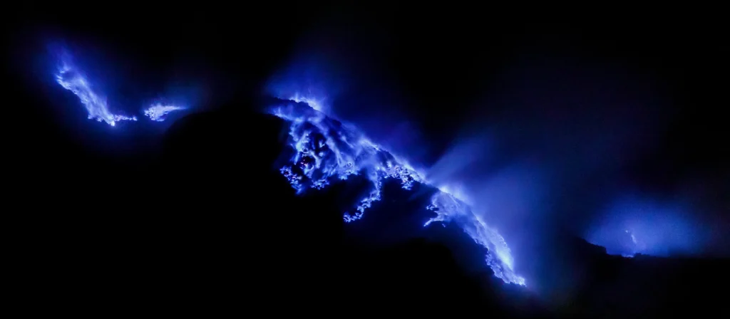
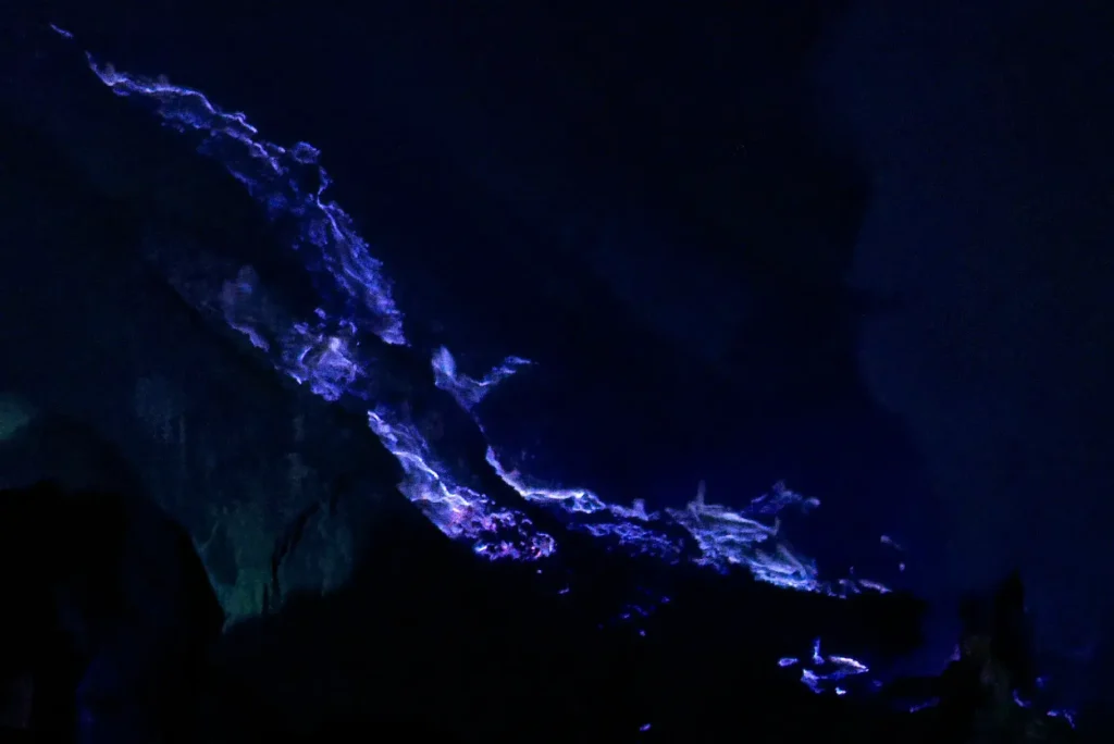
Climb to the rim of Kawah Ijen at two in the morning and look down into the crater, and you will see what looks like blue rivers running over black rock. The glow is fire, not molten rock: jets of sulfur-rich gas, escaping vents as hot as 600°C, igniting the instant they touch the air and burning with flames that can reach five metres. The Paris photographer Olivier Grunewald, whose night images made the place famous, put the correction bluntly to National Geographic: “This blue glow, unusual for a volcano, isn’t, of course, lava, as unfortunately can be read on many websites.”
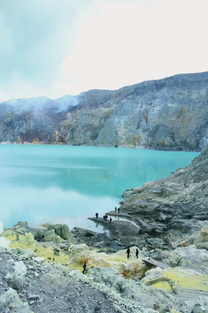
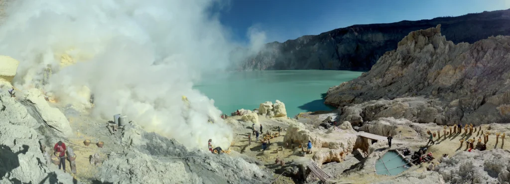
Below those flames sits the second wonder of the place: a kilometre-wide lake of turquoise water that is, by volume, the world’s largest acidic lake, the largest body of hyperacidic water on Earth. Its pH hovers near zero, its dissolved-solids load tops 100 grams per litre, and it would dissolve the clothes off anyone who fell in. Kawah Ijen is the active cone inside the much larger Ijen caldera at the eastern tip of Java, and it has been studied closely enough that we can separate the real numbers from the tourist-brochure ones. This article works through both.
Why is the fire blue at Kawah Ijen?
The color comes from what is burning, not from how hot it is. Kawah Ijen’s fumaroles, cracks and vents in the crater floor and walls, release gases dominated by sulfur dioxide and hydrogen sulfide. When that sulfur-laden gas meets oxygen at high temperature, it combusts, and burning sulfur radiates light strongly in the blue part of the spectrum. The flames glow electric blue for the same reason a gas stove ring burns blue rather than orange.
Two temperatures matter. Sulfur ignites in air at roughly 360°C, and the vent gases at Ijen can emerge far hotter than that. As Grunewald described the mechanism to National Geographic, the gases “emerge from cracks in the volcano at high pressure and temperature, up to 1,112°F (600°C),” and when they touch the air “they ignite, sending flames up to 16 feet (5 meters) high.” At those temperatures the gas lights as soon as it escapes. Some of the sulfur does not burn off as vapor but condenses into a molten liquid that runs downslope while still alight, which is what produces the illusion of glowing blue streams. The molten sulfur is deep red while hot and freezes to bright yellow as it cools.
The flames burn day and night, but daylight washes them out, so they are only visible in the dark. Kawah Ijen is the largest blue-flame area in the world; locals call it Api Biru, “blue fire.” The only other well-known place where the same sulfur combustion can be watched is the Dallol/Danakil hydrothermal area in Ethiopia, a setting Geoscopy has covered in its piece on the Danakil Depression.
Is the “blue lava” at Kawah Ijen real lava?
No. Real lava glows red to orange because of its temperature, typically around 700 to 1,200°C, and its color reflects how hot it is rather than what it is made of. To make lava actually glow blue, you would need temperatures on the order of 6,000°C, hotter than the surface of any lava on Earth and closer to the surface of the Sun. No terrestrial eruption reaches that.
What looks like blue lava at Ijen is burning gas plus burning liquid sulfur. The distinction matters. Kawah Ijen’s most recent confirmed magmatic eruption, the last time fresh molten rock reached the surface, was in 1817, according to the geochemical work of Pierre Delmelle and Alain Bernard. Everything since has been steam-driven (phreatic) activity and persistent degassing, not lava. The blue fire is a surface combustion phenomenon riding on top of a volcano that has not erupted lava in two centuries.
Grunewald and the volcanologist Régis Etienne filmed the flames for a documentary and repeatedly stressed the point because so much online coverage gets it wrong. As Grunewald told Smithsonian, the glow “is due to the combustion of sulfuric gases in contact with air at temperatures above 360°C.” For readers who want the contrast with genuinely strange lava chemistry, Geoscopy’s article on Ol Doinyo Lengai, the volcano that erupts black natrocarbonatite that weathers to white, is a useful companion.
How acidic is the Kawah Ijen crater lake?
About as acidic as natural water gets. The first detailed geochemical study, Delmelle and Bernard’s 1994 paper in Geochimica et Cosmochimica Acta, reported lake water that was hot (around 37°C), strongly mineralized (total dissolved solids of 105 grams per litre), and extremely acidic (pH about 0.4). The authors concluded that “by its volume, the Javanese lake is probably the largest accumulation in the world of such acidic waters.”
Later measurements pushed the pH even lower. A 2001 scientific expedition measured the lake at below 0.3. The Caudron-led 2015 review in the Bulletin of Volcanology noted that over the previous fifty years the lake’s pH had stayed consistently in the range of 0 to 0.4. For comparison, that is in the neighborhood of concentrated battery acid; ordinary stream water sits between pH 6 and 8.
The acidity comes from magmatic gas. Sulfur dioxide, hydrogen chloride, and hydrogen fluoride rising from the shallow hydrothermal system dissolve into the lake’s groundwater-fed body and turn it into a sulfate-chloride brine. Delmelle and Bernard’s downstream study reported the lake water carrying roughly 70,000 mg/kg of sulfate, around 21,000 mg/kg of chloride, about 1,500 mg/kg of fluoride, near 5,000 mg/kg of aluminum, and about 2,000 mg/kg of iron. Those concentrations are why the water is so corrosive and so heavily loaded with dissolved rock.
The lake is also a chemical engine that eats its own crater. Vincent van Hinsberg and colleagues showed in their 2010 work that the brine leaches almost every major and trace element out of the volcanic rock it touches, stripping it nearly clean while enriching only a handful, chiefly lead, tin and antimony, with lead concentrated up to roughly fifteenfold.. The lake is not a sink that locks elements away; it is a source that flushes them downstream.
Can anything live in it?
Barely, and only certain microbes. The first survey of the lake’s biology, by Ansje Löhr and colleagues in Microbial Ecology in 2006, found that the crater lake itself (pH below 0.3) hosted Archaea but no detectable bacteria in the water column. Down the acid river that drains the lake, the Banyupahit-Banyuputih, where pH rises from about 0.4 to 3.5, bacteria and even eukaryotic microorganisms such as algae appeared, but only where the water climbed above pH 2.6. The team concluded that tolerance to this extreme acidity is developed most fully among the Archaea. The lake is one of the most acidic natural habitats on Earth in which life has been documented at all.
How big is the lake, really? The 30-million versus 36-million dispute
Popular sources, including Wikipedia, give the lake a volume of about 36 million cubic metres, a figure the USGS volcanologist Cynthia Werner described to National Geographic as “1.3 billion cubic feet (36 million cubic meters), or about 1/320 of the volume of Oregon’s Crater Lake.” Peer-reviewed measurement gives a smaller number, and the gap is instructive.
The ~36-million figure traces to old soundings. The Caudron review documents that a 1922 estimate and lead-line soundings around 1936 yielded roughly 36.26 million cubic metres, and a 1957 survey by Mueller produced 36.72 million. Those early surveys, taken when the lake was deeper, are the root of the round “36 million” still quoted today.
The first modern bathymetric survey in decades told a different story. Takano and colleagues ran acoustic soundings in 1996 and published the results in 2004 in the Journal of Volcanology and Geothermal Research. They found that after several hydrothermal eruptions the maximum depth had become shallower, about 182 metres, down from roughly 200 metres in earlier surveys, and that the lake volume had dropped to 3.0 × 10⁷ cubic metres, about 30 million. The Smithsonian uses roughly 30 million cubic metres in its hazard assessment, consistent with Takano’s survey.
The honest summary: modern surveys put the lake well below the old figure, Takano’s 1996 acoustic survey gave about 30 million cubic metres, and the most recent echo soundings, taken in 2010–11 and cited in both the Caudron review and the Guinness World Records entry, give roughly 27 million. The older lead-line soundings gave about 36 million. The lake’s depth has genuinely shrunk over the past century, so when a site quotes “36 million” as the current volume, it is repeating a figure that predates every modern survey.
How tall is Kawah Ijen? Why you see two different elevations
Travel pages routinely list Kawah Ijen’s elevation as 2,799 metres. The peer-reviewed literature uses 2,386 metres. Both numbers are correct; they describe different things.
The Ijen complex is a cluster of cones built inside a 20-kilometre-wide caldera. The highest point of that whole complex is a separate stratovolcano called Gunung Merapi, not the famous Merapi near Yogyakarta, but an East Java namesake, which reaches 2,799 metres. The Smithsonian’s Global Volcanism Program treats 2,799 metres as the summit value for the complex as a whole.
The active cone that holds the blue fire and the acid lake sits immediately west of Gunung Merapi and rises to 2,386 metres. That is the figure Delmelle and colleagues use when they describe “Kawah Ijen (2386 m), an active stratovolcano.” So when a hiking blog says you are climbing a 2,799-metre volcano, it has attached the complex’s high point to the wrong cone. The crater rim you actually stand on is closer to 2,386 metres.
The sulfur miners: “devil’s gold” carried by hand
Kawah Ijen is one of the last places on Earth where sulfur is still mined by hand, and the operation has run since 1968. A mining company channels the hottest vent gases through a network of ceramic pipes near the lake’s edge. As the gas cools in the pipes it condenses into molten sulfur, which pours out deep red, pools on the ground, and freezes into bright yellow slabs.
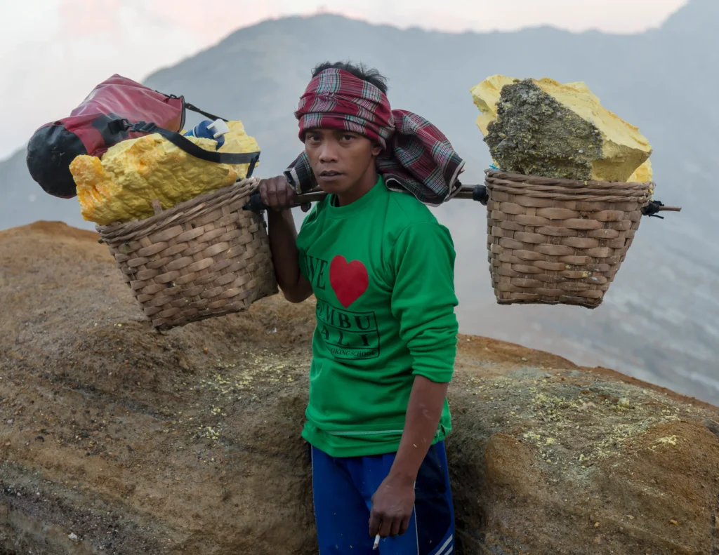
Miners break the slabs apart with steel bars and load the chunks into twin baskets slung from a shoulder pole. A typical load runs from 75 to 90 kilograms, often more than the carrier’s own body weight. They haul it up roughly 300 metres of crater wall on slopes of 45 to 60 degrees, then about three kilometres down the mountain to the weigh station in the Paltuding valley. Most do this twice a day. Accounts of the pay vary, roughly 13 US dollars a day by one 2010 figure; about five dollars a trip and 10 dollars a day in National Geographic’s reporting on the miner Sunarto. All of them outstrip the roughly 4 dollars a day a local rice-field labourer earns, which is why the work is sought after despite being brutal.
The health cost is heavy. Miners work enveloped in sulfur dioxide and hydrogen sulfide, frequently with nothing more than a wet cloth over the mouth, because gas masks are expensive and the filters need replacing. The USGS geologist John Pallister, who has studied the volcano, described the routine as “tough duty” and noted that many miners use only wet cloths for protection. Dental studies cited by the Smithsonian found that laborers suffered more tooth and gum disease than nearby residents with less gas exposure. The miners’ nickname for their product, “devil’s gold”, captures the trade-off.
Is the blue fire dangerous?
The flames themselves are hot enough to kill, but the gas that feeds them is the real hazard. Concentrated sulfur dioxide and hydrogen sulfide can incapacitate a person in seconds when a plume shifts, and the crater floor is exactly where the gas is densest. Visitors who descend to see the blue fire walk into the same air the miners breathe.
The record of harm is concrete. On 21 March 2018, a sudden gas release from the crater, locals call the phenomenon bualan, an overpressure burst of carbon dioxide and hydrogen sulfide from the lake, began around 7 p.m. and sent toxic fumes over nearby hamlets. Sutopo Purwo Nugroho, spokesman for Indonesia’s national disaster mitigation agency, reported that 30 people were poisoned and 24 were taken to the Puskesmas Ijen health center in Bondowoso, with residents of three hamlets, Margahayu, Watu Capil, and Curah Macan, evacuated after experiencing vomiting and difficulty breathing. The crater was closed to tourists, climbers, and miners. The timing was a near miss: the gas came before the usual midnight wave of blue-fire hikers arrived.
The lake can be lethal in other ways. On 29 May 2020, a gas explosion at Ijen generated waves about three metres high on the lake surface; a sulfur miner identified by local emergency officials as Andik, working at the water’s edge with a colleague named Halimik, ran when they heard the boom but slipped and fell into the lake and drowned, his body found floating the next day. Rescue efforts were suspended because of rising gas in the crater. Park authorities close the site without warning when seismicity or gas levels spike, as they did during closures in 2020 and again in 2024.
The disputed 1976 death toll
Many travel sites state that a gas event in 1976 killed 49 sulfur workers, often paired with a claim of 25 deaths in 1989. Other travel accounts give the 1976 figure as 11. Neither number can be confirmed in a primary scientific source, and that is worth saying plainly.
The peer-reviewed review by Caudron and colleagues, which compiled all available historical reports on Kawah Ijen’s activity since 1770, does not record any 1976 or 1989 event at all; its event table jumps from 1962 to 1991. The Smithsonian’s eruption list for Ijen likewise contains no 1976 or 1989 entry. The “49 in 1976” figure circulates mainly through volcano-enthusiast and photo-essay sites, while the “11” appears in first-person travel write-ups citing local guides. Treat both as unverified folklore rather than established fact: the most authoritative catalogue of this volcano’s behavior simply does not list a fatal 1976 event.
The volcano behind the spectacle
Kawah Ijen is a “wet” volcano, meaning its summit holds a crater lake that sits on top of an active magmatic-hydrothermal system. Magmatic gases rise from depth, are absorbed into shallow groundwater, and feed both the acid lake above and the fumaroles that burn blue. Delmelle and colleagues described this as a system that has held a rough dynamic equilibrium for at least the past fifty years, continuously condensing magma-derived fluids into the lake.
That wet character makes the volcano hazardous in a particular way. Because the crater holds tens of millions of cubic metres of acid brine, a phreatic eruption or a failure of the crater wall could send that water downslope as an acidic lahar. The Smithsonian notes that the lake’s roughly 30 million cubic metres could be partly or wholly expelled in such an event, threatening the roughly 5,000 people who live within 10 kilometres and, through the main drainage, the port cities to the north with a combined population near 1.5 million.
The volcano has a documented history of unrest. The Smithsonian and Indonesian agencies record phreatic activity in 1993 (three eruptions on 3–4 July), a small phreatic eruption on 3 February 1994, two phreatic explosions on 28 June 1999, and further activity in 2002. The strongest instrumentally recorded unrest came in 2011–2012. Corentin Caudron and colleagues, writing in the Journal of Geophysical Research: Solid Earth, traced a swarm of distal volcano-tectonic earthquakes in May 2011 to a probable deep magmatic intrusion, followed months later by strong shallow unrest beginning in October 2011; during that episode 237 earthquakes were located, most about a kilometre below the crater lake. Indonesia’s volcano agency, CVGHM/PVMBG, raised the alert level and imposed no-entry zones during the crisis.
Since 2010, Kawah Ijen has become one of the best-monitored volcanoes in Indonesia, with permanent seismometers and lake sensors installed in the crater. That monitoring is why the 2011–2012 unrest is so well documented and why authorities can close the site quickly when readings climb. The blue glow that draws crowds rides on a system that is watched around the clock. Geoscopy’s piece on earthquake lights explores another luminous geophysical phenomenon that has taken decades to explain.
Can you visit Kawah Ijen to see the blue fire?
Yes, and many do, by some accounts tens of thousands and in peak periods hundreds of thousands of visitors a year, but it is a guided night hike into an active crater rather than a casual walk. Most trips start from Banyuwangi on Java’s far eastern coast, easily reached by ferry from Bali. The main trail climbs about three kilometres to the crater rim, a hike of roughly an hour and a half to two hours, with a steep descent of several hundred metres from the rim to the lake shore over rocky, slippery ground.
Because the flames only show in darkness, hikers leave in the small hours to reach the crater floor before dawn. A gas mask with working filters is not optional; the air at the flame site is genuinely toxic, and tour operators typically supply masks and tell visitors when to put them on. Sturdy footwear and a headlamp matter, and anyone with asthma or a heart condition should watch the lake from the rim rather than descend.
The site has gained formal recognition. The Ijen UNESCO Global Geopark was designated at the 216th UNESCO Executive Council meeting in Paris on 24 May 2023, one of 18 new global geoparks named that session. Closures happen with little notice when the volcano stirs, so checking the current alert level from Indonesia’s geological agency before booking is sensible. The blue fire is also weather-dependent: rain, wind, and steam can hide it entirely even on an active night.
Frequently asked questions
What causes the blue fire at Kawah Ijen?
Sulfur-rich volcanic gas escapes the crater’s fumaroles at temperatures that can reach about 600°C and ignites on contact with oxygen in the air. Burning sulfur emits blue light, so the flames glow electric blue. Some sulfur condenses into molten liquid that flows downhill while still burning, which creates the look of blue rivers.
Is blue lava real?
Not in the sense people usually mean. Lava glows red to orange because of its temperature; producing blue light from incandescence alone would require roughly 6,000°C, far hotter than any lava on Earth. The “blue lava” of Kawah Ijen is burning sulfur gas and molten sulfur, not glowing rock.
How acidic is the Kawah Ijen crater lake?
Its pH has stayed roughly between 0 and 0.4 over the past half-century, with expedition measurements below 0.3 and total dissolved solids above 100 grams per litre. That is comparable to concentrated battery acid and is corrosive enough to dissolve fabric and metal, which is why swimming is forbidden and contact is dangerous.
When did Kawah Ijen last erupt?
Its last confirmed magmatic eruption, fresh molten rock at the surface, was in 1817. Since then the volcano has produced steam-driven phreatic eruptions and gas events, including activity in 1993, 1994, 1999, and 2002, plus a strong seismic unrest episode in 2011–2012 and toxic-gas releases in 2018 and 2020.
How much do the sulfur miners earn?
Estimates range from about five dollars a trip to roughly 13 US dollars a day. They carry loads of about 75 to 90 kilograms up the crater wall and three kilometres down the mountain, usually twice daily, often with minimal respiratory protection. It is well paid by local standards and physically punishing.
Is it safe to visit?
It is generally manageable with a guide, a working gas mask, and good footwear, but it is an active volcano with real risks from toxic gas. Authorities close the crater without warning when activity rises, and people with breathing or heart conditions should stay at the rim. Sudden gas bursts have hospitalized and killed people, so the hazard is not theoretical.