Introduction
On 6 June 1961, the needles on long-period seismographs scattered across the planet began tracing the same slow, insistent wobble at the same moment. For roughly eight hours the signal swelled and faded in regular beats, sinusoidal and almost too clean to be natural, with a period close to 27 seconds. No earthquake had announced it, and no volcano was erupting beneath it. And yet there it was, recorded on paper drums an ocean apart, a worldwide storm of microseisms arriving from somewhere in the equatorial Atlantic.
The young seismologist who chased that signal down, Jack Oliver, had no way of knowing he was looking at the first careful description of something that would still be unexplained sixty-five years later. The 26-second microseism, the “heartbeat” that the internet would eventually fall in love with, keeps a metronome buried somewhere off the coast of West Africa. It has been ticking since before anyone was watching, and despite decades of cleverer instruments and sharper math, the question of what actually drives it remains open. This is the story of that pulse: what it is, who found it, where it lives, and why the most honest answer a seismologist can give you in 2026 is still “we don’t know.”
What the 26-second pulse actually is
The 26-second pulse is a faint, continuous seismic signal, technically a microseism, that radiates from a fixed point in the Gulf of Guinea off West Africa, repeating with a period of about 26 seconds (a frequency near 0.038 hertz). It has been recorded worldwide since 1961, travels as Rayleigh surface waves, and despite sixty-five years of study its cause remains unexplained.
Start with the word that geophysicists use, because it strips away the mysticism: microseism. A microseism is a faint, persistent ground vibration that has nothing to do with earthquakes. The Earth’s crust is never truly still. Even on a calm day, far from any traffic or fault rupture, seismometers register a low background hum, and most of that hum traces back to the oceans. Mike Ritzwoller, a seismologist at the University of Colorado Boulder who has spent much of his career reading this noise, puts the chain of cause and effect bluntly: seismic noise exists because of the Sun. Sunlight heats the equator more than the poles, that imbalance drives wind, wind raises waves, and when waves reach a coastline or interfere with one another over the deep sea, they press rhythmically on the solid Earth and set it ringing.
The 26-second signal sits inside that ocean-driven background as something stranger than the rest of it. Where ordinary microseismic noise is broadband and smeared across a range of frequencies, this one is a spike, a narrow spectral line centered near a period of 26 seconds, which works out to a frequency of about 0.038 hertz. That is far below anything a human ear could register; the lowest note most people can hear sits around 20 hertz, more than five hundred times faster. Charlotte Bruland and Céline Hadziioannou, two geophysicists at the University of Hamburg who studied the signal recently, reached for a musical image to convey the scale of it. They compare the tone to a bass clarinet, except, as Hadziioannou described it, you would need a clarinet roughly ten kilometers long buried in the ground to play a note that deep.
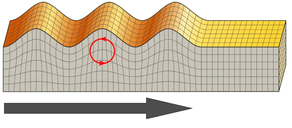
The motion itself travels mostly as Rayleigh waves, a kind of surface wave in which the ground rolls in a backward elliptical orbit, the same way a swell moves through open water. Rayleigh waves stay near the surface and carry their energy efficiently over enormous distances, which is exactly why a single small source near the equator can register on instruments in Europe, North America, and across Africa. Shapiro, Ritzwoller and Bensen measured the apparent speed of these arrivals at about 3.5 kilometers per second, close to the expected group velocity of Rayleigh waves at this period, a tidy confirmation that what stations around the world are recording really is one signal radiating outward, not a coincidence of local noise.
Two more properties make the signal genuinely odd. First, it is remarkably stable in location and frequency, behaving less like weather and more like a fixed transmitter that someone switched on decades ago and never turned off. Second, and this is the detail that has frustrated the simplest explanations, it is largely nondispersive. In a dispersive signal, different frequencies travel at different speeds, the way deep-water ocean swell sorts itself out so that long waves outrun short ones. The 26-second peak does not do that in the way a deep-water-wave origin would predict, a point that became central once Gary Holcomb examined it closely in 1980.
The discovery story: Oliver, Holcomb, and a signal that got forgotten
Jack Oliver and the 1961 storm
Jack Oliver was not, in 1961, hunting for a planetary heartbeat. He was a Lamont seismologist in the thick of the work that would make his name, and within a few years he would co-author one of the foundational papers of plate tectonics, “Seismology and the New Global Tectonics,” published in 1968 with Bryan Isacks and Lynn Sykes, a paper a former student later called the bible of the field. Oliver had earned his geophysics PhD at Columbia in 1953 under Maurice “Doc” Ewing and went on to head Lamont’s seismology program from 1955 to 1971. The 26-second signal was, by comparison, a curiosity that landed on his desk almost by accident: a colleague, Ruth Simon, drew his attention to the unusual microseism storm showing up on the Palisades records.
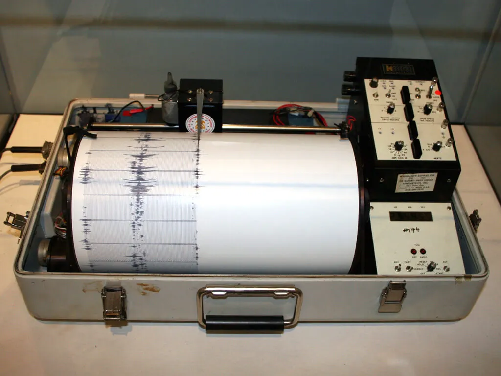
What Oliver could do with it in 1962 was limited by his tools. He worked from paper seismograms, not digital data, a constraint Ritzwoller would later point to as the gulf between what was possible in 1962 and what his own team could do in 2005. Even so, Oliver got the essentials right. In his 1962 paper, titled with characteristic precision “A worldwide storm of microseisms with periods of about 27 seconds,” he established that the waves were largely of the Rayleigh type, that they had been detected globally, and that they seemed to originate in the southern or equatorial Atlantic Ocean. His favored explanation was that dispersed ocean waves striking the coast of the Gulf of Guinea had generated them. A year later, in a 1963 follow-up, he reported that mariners’ observations of unusual swell, at the times and places his hypothesis predicted, lent support to the ocean-wave idea.
One detail from Oliver’s record has taken on new meaning since. He described that 1961 event as a storm lasting about two days during which the period slid from roughly 28 down to about 20 seconds, a drifting, gliding tone. Decades later the Hamburg group would argue that Oliver had, without realizing it, captured the very first observation of a phenomenon they would name a “frequency glide.” His paper title’s hedge, “about 27 seconds,” not 26, and certainly not the “27 to 30” that careless retellings sometimes claim, is worth honoring, because it reflects exactly the ambiguity of a signal whose frequency wanders.
Gary Holcomb and the nondispersive problem
About two decades passed before anyone looked hard at the signal again. In 1980 Gary Holcomb, a geologist with the U.S. Geological Survey, published “Microseisms: A twenty-six-second spectral line in long-period earth motion” in the Bulletin of the Seismological Society of America. Holcomb confirmed that a narrow-band peak near 26 seconds was a persistent fixture of the Earth’s background, that its amplitude shot up during storms, letting him study it in detail when it was loud, and that the energy arrived as Rayleigh waves from a source in the southern Atlantic.
His most consequential finding was the one that complicated everyone’s life: the peak is nondispersive. That mattered because the obvious explanation for an ocean-generated signal would invoke deep-water wave dispersion to isolate a narrow band of energy, and a nondispersive signal rules that particular mechanism out. Holcomb’s result meant that whatever was producing the 26-second line, it was not simply deep-water ocean waves sorting themselves by frequency. In a later 1998 study spanning 20 to 40 seconds of period, he added that the peak’s amplitude maximizes during the southern hemisphere winter, a seasonality pointing toward an atmospheric or oceanic driver. Then the trail went cold. Holcomb’s and Oliver’s papers slid into obscurity, cited rarely, while the drumbeat kept going beneath everyone’s feet, unwatched.
2005: a graduate student stumbles on it again
The pulse came back into view in 2005 in a Boulder lab, and the way it happened has become a small legend in seismology. Greg Bensen, then a graduate student at the University of Colorado Boulder, was working through seismic data using a technique called ambient noise cross-correlation, a method that mines the constant background hum to extract information about the Earth’s interior. His advisor, Ritzwoller, walked in and asked what he was working on. Bensen pulled up the data, and there it was: a strong, repeating arrival coming from somewhere far away. As Ritzwoller tells it, he and the postdoctoral researcher Nikolai Shapiro recognized immediately that something was strange, while having no idea what it was.
The team did what good scientists do with an anomaly. They checked the instruments. They checked the analysis. They examined the blips from every angle to rule out an artifact, and every test said the signal was real and out there in the world. Using the arrival-time differences between stations, they triangulated the source to the Gulf of Guinea, off the western coast of Africa. Digging into the literature, they rediscovered Oliver’s and Holcomb’s all-but-forgotten work and connected it to what they were seeing. The result was a 2006 paper in Geophysical Research Letters, Shapiro, Ritzwoller and Bensen, “Source location of the 26 sec microseism from cross-correlations of ambient seismic noise”, that revived the entire question.
That 2006 study did more than relocate the source. It showed that the signal’s location is temporally stable across months, that its amplitude maximizes during the southern hemisphere winter (echoing Holcomb), and that a similar but slightly broader-banded microseism appears in East Asia and the western Pacific, apparently originating in the North Fiji Basin near the antipode of the Gulf of Guinea. From that near-antipodal pairing the authors floated the idea that the 26-second signals might be excited by a single source in the Gulf of Guinea. (A note for the careful reader: this 2006 GRL location paper is a separate publication from the 2007 Geophysical Journal International methods paper by Bensen and colleagues, which dealt with how to process ambient-noise data and, among other things, how to filter the troublesome 26-second resonance out of cross-correlations. The two are routinely conflated online; they are not the same paper.)
Garrett Euler and the Bight of Bonny
Six years after the 2006 revival, the location tightened again. Garrett Euler, a graduate student in the seismologist Doug Wiens’s lab at Washington University in St. Louis, applied array-based noise-correlation and frequency-slowness analysis to data from temporary seismic deployments across Africa. He narrowed the 26-second source from the broad Gulf of Guinea to a specific stretch of it: the Bight of Bonny, the inner corner of the gulf where the coastline bends, with the signal sitting on the continental shelf in its northern portion. Euler presented this result at the Seismological Society of America’s annual meeting in 2013.
Here a frequent citation error is worth flagging. Euler’s peer-reviewed 2014 paper with Wiens and Andrew Nyblade in Geophysical Journal International, “Evidence for bathymetric control on the distribution of body wave microseism sources from temporary seismic arrays in Africa,” is principally about shorter-period (roughly 5 to 10 second) P-wave microseisms and argues that seafloor shape, bathymetry, together with ocean wave heights governs where body-wave microseisms are generated. The specific narrowing of the 26-second Rayleigh-wave source to the Bight of Bonny came through Euler’s conference work, not a separate 2013 journal article. The distinction matters because retellings often invent a tidy “2013 Euler paper” that does not exist in the form described.
Euler and Wiens also offered a physical rationale for an ocean-wave origin. As Wiens explains it, when waves travel across the open ocean the pressure differences they create barely reach the deep seafloor. But when those waves run up onto a continental shelf, where the solid seabed lies much closer to the surface, the changing pressure can deform the shelf and pump seismic energy into the crust, in his words, “the pressure deforms the ocean floor (much like knocking on a desk deforms the surface) and causes seismic pulses that reflect the wave action.” Ritzwoller’s version of the same analogy is a knuckle rapping a table: the tap deforms the wood right at the knuckle, but the vibration carries across the whole tabletop so that someone resting a cheek on the far edge feels it. In this picture the Bight of Bonny is the knuckle, and the planet is the table.
Why the Bight of Bonny?
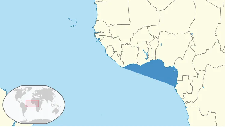
The source location is strikingly placed. It sits near the spot where the prime meridian crosses the equator, approximate coordinates (0, 0), the cartographic origin of the world, in the warm, oil-rich waters of the Bight of Bonny. This is a corner of the planet with a complicated geology. It marks the offshore stretch of the Cameroon Volcanic Line, a roughly 1,600-kilometer chain of volcanoes and intrusions that runs from islands in the Gulf of Guinea, Annobón, São Tomé, Príncipe, and Bioko, northeast onto the African mainland, where it culminates in Mount Cameroon, a 4,040-meter active volcano whose most recent eruption occurred in 2012. The line is geologically peculiar: it crosses both oceanic and continental crust and shows no clear age progression along its length, which is why geologists classify it as a volcanic “hot-line” rather than a simple hotspot track.
That setting cuts both ways for explaining the pulse, and it is the root of the central debate. On the one hand, the Bight of Bonny has a broad continental shelf and faces the long-traveled swell of the South Atlantic, promising ingredients for a wave-driven microseism. On the other hand, it sits beside a chain of volcanoes and the fluid-rich sediments of a major hydrocarbon province, which is promising for a volcanic or hydrothermal origin. The uncomfortable question that hangs over every hypothesis is the one Discover Magazine put plainly: “There are plenty of other continental shelves and volcanoes around the world that, as far as we know, aren’t causing seismic pulses, what’s so special about the Bight of Bonny?” Nobody has a satisfying answer for the uniqueness.
What causes the 26-second pulse? Ocean waves versus volcano
The wave-and-coast camp
The oldest idea is also the most intuitive, and it traces straight back to Oliver in 1962: ocean swell striking the West African coast and shelf generates the signal. Euler and Wiens sharpened this into the continental-shelf mechanism described above, in which wave pressure deforms the shallow seabed of the Bight of Bonny and radiates Rayleigh waves outward. The seasonal behavior fits reasonably well, since the peak strengthens during the southern hemisphere winter when South Atlantic storms are most vigorous and the swell reaching the gulf is largest. Holcomb’s storm correlation and the maximum during southern winter both point a finger at the ocean.
The wave camp has a stubborn problem, though, and it is Holcomb’s nondispersive result. If the signal were straightforwardly produced by deep-water ocean-wave dispersion, it should carry a dispersive signature it does not have. Producing a sharp, persistent, single-frequency tone from broadband ocean swell requires some additional trick, a resonance, a feedback, a tuned structure, and that requirement is what keeps the door open for the rival explanation.
The volcanic camp
In 2013 a team led by Yingjie Xia at the Institute of Geodesy and Geophysics in Wuhan, China, published a different reading in Geophysical Journal International. Their paper, “Twin enigmatic microseismic sources in the Gulf of Guinea observed on intercontinental seismic stations,” reported not one but two persistent, spatially localized, monochromatic sources in the gulf: one near 0.036 hertz (a period of about 28 seconds) and one near 0.038 hertz (the classic 26 seconds). The 0.036-hertz source sits close to the São Tomé volcano, which led them to suggest it is tied to volcanic processes. The 0.038-hertz source, the famous one, they could not explain by any known tectonic or oceanic mechanism, and they argued the most likely driver was still volcanic, despite the awkward fact that no active volcano has been identified at that particular spot.
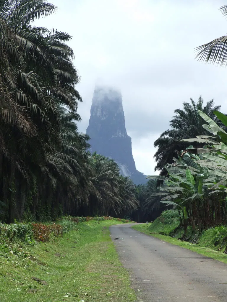
The volcanic hypothesis is not arbitrary. Volcanic and hydrothermal systems are among the few things on Earth capable of continuously feeding energy into a single location and generating sustained, near-monochromatic ground motion, what volcanologists call tremor. There is even a real-world precedent: as Discover Magazine noted, “there is at least one other place on Earth where a volcano does cause a microseism with some similarities to this one,” and that place is Aso Volcano in Japan. Aso’s long-period tremor was first documented in the 1930s, when Kenzo Sassa of Kyoto University reported it from long-period seismometers at the volcano, and the activity has persisted ever since. São Tomé itself wears its volcanic origin on its sleeve. The island’s signature landmark, Pico Cão Grande, “Great Dog Peak”, is a 663-meter spire of phonolite that rises some 370 meters straight out of the rainforest, the eroded plug of an ancient volcano that solidified in a vent roughly three and a half million years ago. It is a vivid reminder that this is, geologically, a volcanic neighborhood.
But the volcanic camp has its own gap, and it is glaring: the 26-second source does not sit on a known active volcano. The 28-second and 16-second sources hug the Cameroon Volcanic Line and have a plausible magmatic home, yet the 26-second signal lands in water with no obvious volcanic edifice beneath it. Calling it volcanic therefore requires positing a hidden or unconventional system, exactly the kind of thing that is hard to confirm and easy to argue about.
The 2023 twist: gliding tremors and a hydrothermal whistle
The most substantial recent attempt to crack the problem came in May 2023, when Charlotte Bruland and Céline Hadziioannou of the University of Hamburg published “Gliding tremors associated with the 26 second microseism in the Gulf of Guinea” in Communications Earth & Environment. Working with three-component data from two seismic arrays in Africa plus stations compiled from around the world, they found something new riding alongside the familiar 26-second tone: frequency glides. These are tremor episodes in which the frequency ramps steadily, gliding upward, rather than holding a single pitch. Crucially, the glides start at the same frequency as the 26-second peak and originate from the same fixed location in the gulf, tying the two phenomena together.
The glides behave erratically in time. They appear every few days, can last for hours or even days, and then sometimes vanish for a month, with no clear seasonal preference. When they flare up, they can be surprisingly energetic. The strongest bursts in the 26-second band can rival the seismic energy of a magnitude-5 earthquake, a figure first reported by Xia and colleagues, and, like the steady tone, can be detected on quiet stations worldwide. Bruland and Hadziioannou also reinterpreted Oliver’s 1961 storm, that two-day event with the period drifting from 28 down toward 20 seconds, as very likely the first recorded example of one of these glides, drawing a line from the discovery in 1962 straight to their own observations.
For a mechanism, they proposed something that blends both camps rather than choosing between them: pulsed gas release from a hydrothermal system, possibly modulated by storm-generated ocean swell. The intuition, as Hadziioannou put it, is that “gas regularly escaping from the Earth’s interior is forced through some kind of volcanic conduit and then through smaller cracks,” and that process, the conduit and cracks acting like the bore of that imaginary ten-kilometer clarinet, could generate the deep, sustained tone. Ocean storms might then modulate when and how strongly the system “plays,” which would neatly explain both the storm correlation that points to the ocean and the resonant, tremor-like character that points to a volcanic-style source.
The origin of these seismic waves “remains enigmatic to date.”Bruland & Hadziioannou, Communications Earth & Environment, 2023
It is essential to be clear about what this 2023 paper did and did not do, because plenty of headlines got it wrong. It did not solve the mystery. The authors explicitly called the origin enigmatic and framed pulsed hydrothermal gas release as the most likely explanation among several, while leaving the external driver of the glide events unresolved. They argued, reasonably, that the signal’s stability, its low frequency, the large physical scale it implies, and the decades over which it has persisted together expose a real gap in how geophysicists understand long-period oceanic and volcanic signals. Their closing point has a practical edge: because tremor is one of the standard tools for monitoring volcanoes, getting the 26-second source right could sharpen how seismologists read volcanic tremor elsewhere, and the signal stands as a reminder of how much remains unknown about the deep, slow processes the Earth produces.
The 2026 paper: ocean swell makes a comeback
In April 2026 the pendulum swung back toward the ocean, though, again, without anyone claiming victory. A team led by Piero Poli, with the oceanographer Fabrice Ardhuin, Tomoya Takano, and the INGV seismologist Stefania Tarantino among the authors, published “Swell-driven bursts of 26 s and 16 s seismic spectral peaks in the Gulf of Guinea” in Nature Communications. Their approach was deliberately interdisciplinary: roughly four years of continuous seismic data from 2021 to 2024 recorded by a network of stations in southern France, supplemented by a Cameroon array and a coastal Cameroon station, cross-referenced against a global ocean-wave model in the WAVEWATCH III framework and satellite altimetry from the SWOT mission.
What they found is the most quantitative link yet between the seismic bursts and the sea. By tracking individual Southern Ocean storms, including two in July and August 2023 that whipped up significant wave heights as high as roughly 15 meters, and following the resulting swell as it propagated north toward the Gulf of Guinea, they established a statistical, causal-looking relationship: when swell with periods near 16 or 26 seconds arrives at the gulf’s coastal region, the corresponding seismic peaks switch on. The bursts, in other words, are triggered by the passage of distant storm swell of matching period.
For the mechanism, the team proposed that the swell does not simply convert into seismic energy directly. Instead, the arriving swell appears to dynamically trigger the resonance of fluid-filled cracks in the crust, with fluid movement amplifying and tuning the response into the narrow 16- and 26-second lines. Modeling the resonance with a water-filled crack implied a structure a few kilometers long and a few meters wide, dimensions they note are consistent with the region’s documented seepage features, pockmarks, and mud-volcano geology. The appeal of this picture is that it ties the tone to the ocean’s rhythm while still invoking a tuned subsurface structure to produce the sharp single frequency, and it does so, in their framing, with a mechanism that “does not require undocumented active volcanic systems.”
And once again, the honest framing is hedged. The authors write that the signals “may be associated with resonance cracks dynamically triggered by swell activity,” acknowledge that alternative interpretations such as thin-plate vibrations “remain viable,” and state plainly that further observational and theoretical work will be needed to discriminate among the competing models. The 2026 study revives and quantifies the ocean-swell interpretation that goes all the way back to Oliver; it does not close the case. If anything, it reframes the question from “waves or volcano?” to “how exactly does ordinary swell get converted into an extraordinary, tuned, planet-spanning tone?”
Why is the 26-second pulse still unsolved?
Sixty-five years after Oliver first wrote it up, the 26-second microseism is genuinely, honestly unsolved. The competing explanations have converged somewhat, most current thinking involves some marriage of ocean forcing and a resonant subsurface structure, whether that structure is a hydrothermal conduit or a fluid-filled crack, but no one has produced a mechanism that explains every observation and that the community has accepted as settled. The signal’s defining features remain partly contradictory: it is narrow-band and tuned like a resonator, storm-correlated and seasonal like an ocean signal, nondispersive in a way that rules out the simplest wave mechanism, and parked at a unique location that no general theory predicts.
Part of the reason it has lingered is, frankly, priority. As Wiens has acknowledged, seismologists mostly study the signal as a way of understanding the deep structure of the Earth, and the 26-second pulse sits a little outside that core mission, it does not tell you much about the mantle or the core, so it has rarely been anyone’s top funding priority. The pulse has often been treated as noise to be filtered out rather than a target to be explained; the 2007 methods paper literally describes how to scrub the 26-second resonance out of ambient-noise correlations so it stops contaminating other measurements. There is a quiet irony in a signal so persistent that researchers built filters to ignore it.
That neglect is also why the story carries a certain charm, and why it escaped the journals to become an internet phenomenon. The webcomic xkcd devoted strip #2344, “26-Second Pulse,” to it, having a student explain the triangulated Gulf of Guinea source before veering into a darkly comic suggestion that the beat is the still-beating heart of a giant murdered by seismologists, an Edgar Allan Poe joke that captures the eeriness of a planet with a pulse no one ordered. Real seismologists have found a genuinely useful application for the signal’s regularity, too: because the tone is so stable, it can be used to detect and correct timing drift in historic seismic records, turning the mystery into a precision clock.
Ritzwoller frames the open question as a feature of the science rather than a bug. He has said the team is still waiting for the fundamental explanation, and that the lasting lesson is how many basic, interesting phenomena are known to exist in the Earth and still keep their secrets. It may take a future generation of students, working with denser ocean-bottom networks and better physics, to finally name what is humming under the Bight of Bonny. For now, the most rigorous position is also the most candid: we have narrowed the where to within a stretch of seafloor, we have a strong case that ocean swell is involved in switching it on, we have credible models for a resonant source, and we still cannot say for certain what the resonator is.
Why it matters
It would be easy to file the 26-second pulse under harmless trivia, but it earns its keep in a few real ways. The methods built to chase it, ambient-noise cross-correlation and array beamforming, are now central tools for imaging the Earth’s interior and monitoring volcanoes, and the pulse has served as a stubborn, well-behaved test case for refining them. The link between ocean storms and a tuned crustal resonance, if it holds, would be a textbook example of how tightly coupled the atmosphere, ocean, and solid Earth really are, with energy from a storm in the Southern Ocean migrating thousands of kilometers and getting converted into a seismic note radiated to the entire planet. And because the signal may involve fluid-filled cracks or a hydrothermal system, understanding it could sharpen the interpretation of volcanic tremor elsewhere, where reading the subsurface plumbing correctly can be a matter of forecasting eruptions.
There is also a less utilitarian reason to care. The 26-second microseism is a reminder that the planet has not been fully mapped and explained. It has been detectable on instruments worldwide for more than six decades, it pulses at coordinates close to the literal center of our map of the world, and the most accurate thing science can say about its cause is still framed as a hypothesis. The Earth keeps time on a clock we did not build and cannot yet read.
If this kind of slow, hidden geophysics appeals to you, Geoscopy has chased other planetary enigmas in the same spirit. Read about the Indian Ocean gravity hole, a vast low in Earth’s gravity field that is as poorly explained as it is enormous; the eerie phenomenon of earthquake lights; the deepest artificial wound in the crust at the Kola Superdeep Borehole; and the electrical fury of volcanic lightning.
The pulse goes on
As you read this sentence, somewhere beneath the warm water of the Bight of Bonny, the Earth has ticked again. It ticked while Oliver squinted at paper drums in 1962, while Holcomb tracked its nondispersive line in 1980, while Bensen pulled it out of a dataset in 2005, and while two Hamburg geophysicists compared it to a buried clarinet in 2023. It will tick roughly 3,300 more times before tomorrow. Whatever it is, a resonating crack breathing storm swell, a hidden hydrothermal whistle, something not yet imagined, it has kept perfect, indifferent time through every theory raised to explain it.
Frequently asked questions
Has the 26-second pulse been solved? No. After sixty-five years, the most current research narrows the source and strongly implicates ocean swell, but no accepted mechanism explains every observation.
Where does the 26-second pulse come from? A fixed point in the Bight of Bonny, the inner corner of the Gulf of Guinea off West Africa, near where the prime meridian crosses the equator.
What causes it? The leading candidates are ocean swell deforming the continental shelf and a resonant subsurface structure such as a fluid-filled crack or hydrothermal conduit; the 2026 evidence favors swell triggering a tuned crustal resonance.