Argoland: The Lost Continent Hidden Under Indonesia
Pascal
May 24, 2026
Introduction
Argoland is a lost continent that broke off northwest Australia roughly 155 million years ago and drifted into Southeast Asia. It is also, as it turns out, not really one continent at all. For decades, the Argo Abyssal Plain off the Pilbara coast told geologists it had left, but not where it had gone. In a 2024 paper, published online in October 2023, two researchers at Utrecht University finally explained how it made the journey, and why it stopped looking like a continent.
The Argo Abyssal Plain: The Void Off Western Australia
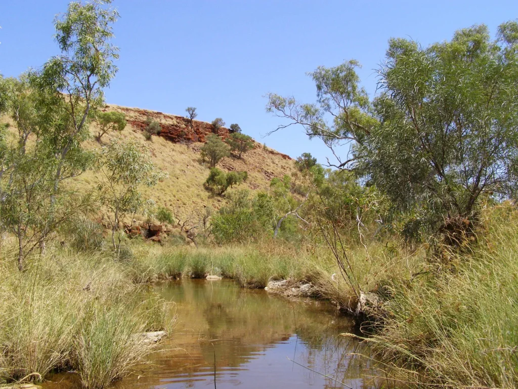
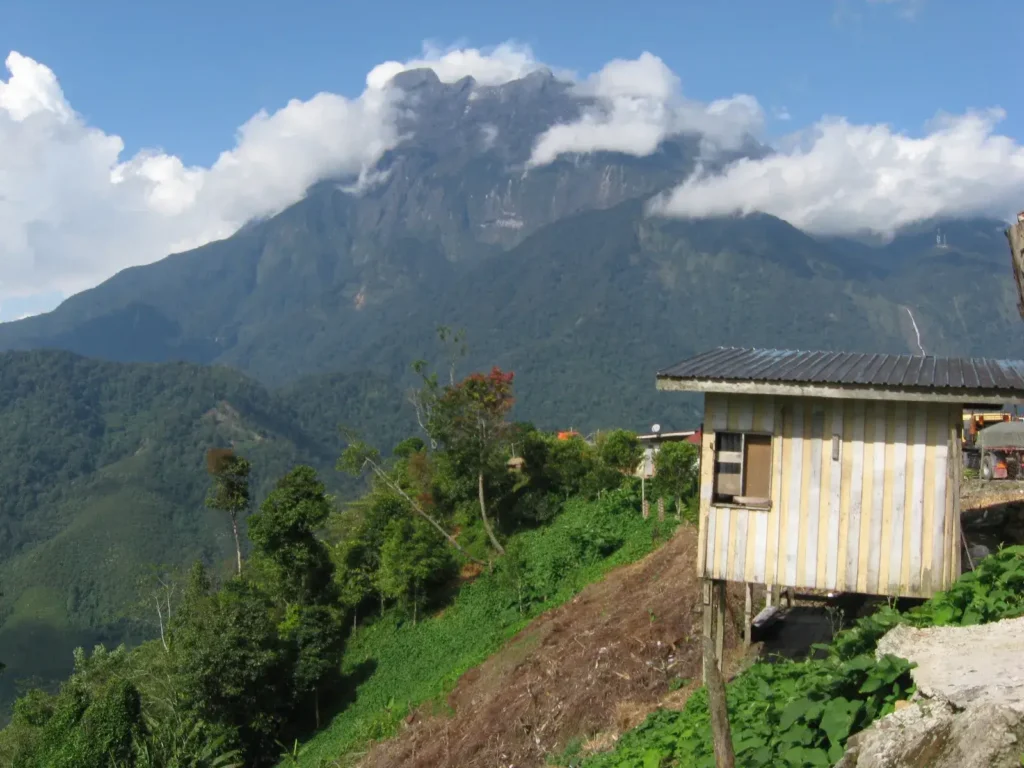
The Hamersley Range, Pilbara, Western Australia, the inland edge of the margin from which Argoland rifted away in the Late Jurassic. Source: Wikimedia Commons, CC BY-SA.
Several hundred kilometres off the Pilbara coast of Western Australia, beyond the seaward edge of the Exmouth Plateau, the seafloor falls away into a basin that looks, on a contour map, like a long blue rectangle pressed against the continental shelf. This is the Argo Abyssal Plain. It is bounded by the 5,600-metre contour and reaches a maximum depth of 5,730 metres against the inshore side of the Exmouth Plateau, with Joey Rise hemming it in to the southwest and Roo Rise farther west. Drilled, dredged, and surveyed since the late 1970s, the plain is, in a literal sense, the deepest hole in Australia’s geological story.
What makes it strange is not its depth. It is its age, and the shape of what is missing above it. The oceanic crust beneath the Argo plain dates from the Late Jurassic, with marine magnetic anomalies stepping cleanly from M26 (156.56 Ma on the Gradstein 2020 timescale) outward, recording the moment a mid-ocean ridge first opened along the northwest Australian margin. Magnetic stripes carry the same blunt information about every spreading center on Earth: when the ridge opened, what plate moved away, and in roughly which direction. Read the Argo stripes outward from the Exmouth Plateau and they say something specific. A piece of continent broke off here, roughly 5,000 kilometers long, and drifted to the northwest.
That is what a continent’s departure looks like in the rock record. The void where it used to be fills with new ocean floor; the new ocean floor remembers, in iron-bearing minerals locked to Earth’s reversing magnetic field, which way the missing piece went. That Argoland existed is not in doubt. What happened to it afterwards is.
The Argo stripes set up a problem with a fairly tight geometry. The vanished slab had to start at the northern Australian margin, bounded in the east by the Bird’s Head region of what is now West Papua, and in the west by the Wallaby–Zenith Fracture Zone: a deep oceanic scar running through approximately 22°S, 102°E, where ridge-transform offsets in the early Indian Ocean cut a step into the crust that has been surveyed during Expedition SO258 to a maximum depth of 6,625 meters. The slab had to drift northward, into the Tethys Ocean, the warm-water Mesozoic seaway that lay between Gondwana and Laurasia, and it had to end up somewhere in present-day Southeast Asia.
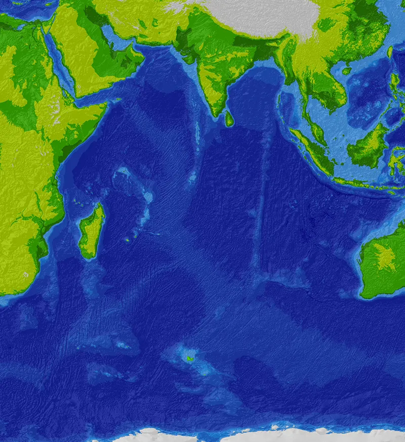
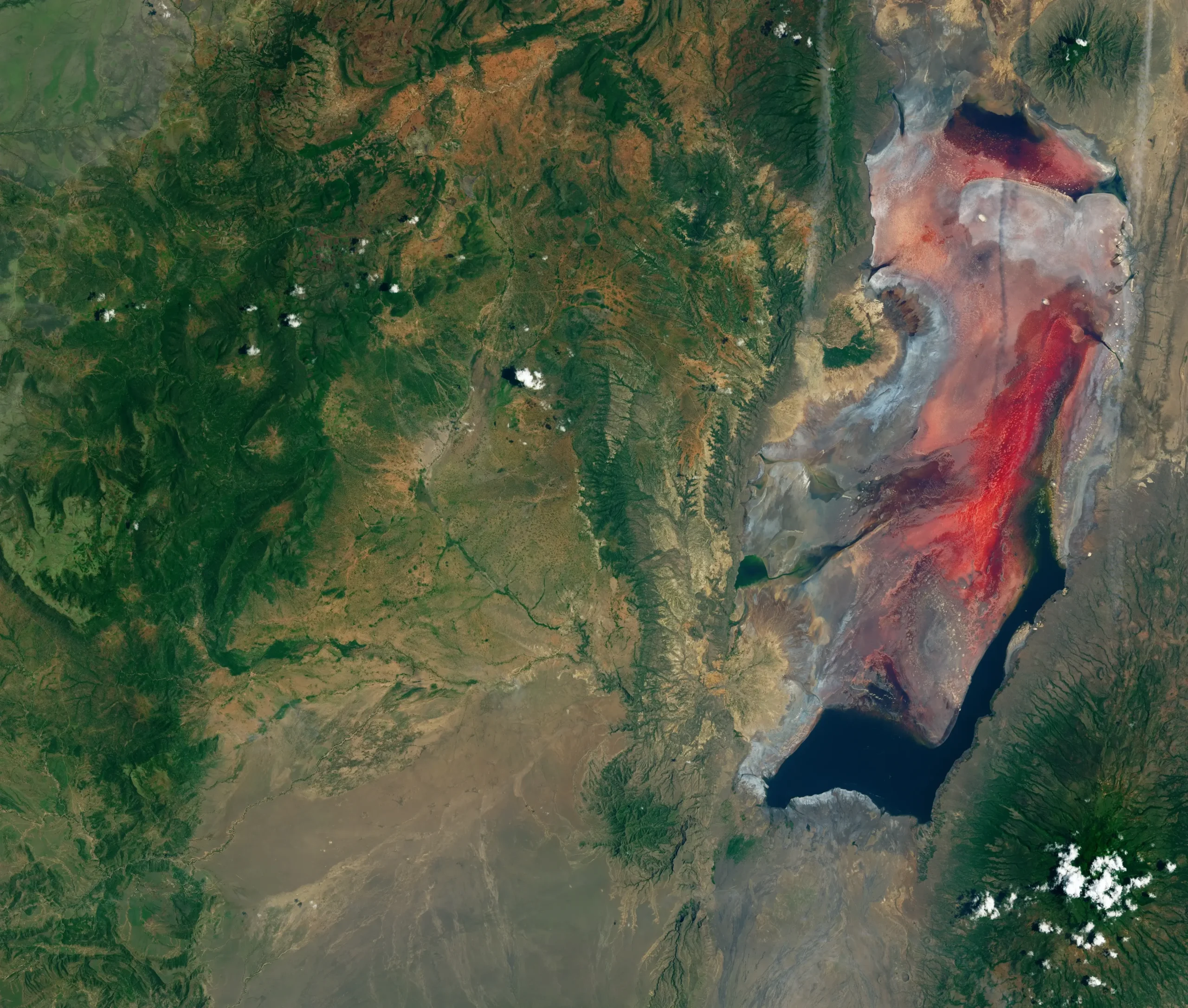
Bathymetry of the Indian Ocean. The deep blue basin off the northwest Australian coast, the Argo Abyssal Plain, is the void left behind when Argoland rifted away in the Late Jurassic. The shallow Sundaland shelf to the north, beneath Indonesia and Malaysia, contains the fragments of the continent that disappeared. Source: SRTM30_plus 30 arc-second satellite data, CC BY-SA 3.0.
Here is where the geometry runs into trouble. India, which broke off Gondwana about 30 million years later, is still a tidy continent. It plowed into Asia, raised the Himalayas, and remains visible from orbit. Australia and Antarctica are still recognizable. But run the projections forward from the Argo stripes and you should arrive at another India-sized continent jammed somewhere into the Indonesian archipelago. There is no such thing. Instead there is one of the most geologically scrambled regions on the planet: an accretionary orogen built of ribbons of continental rock, slivers of ocean floor, ophiolites stacked between, and Cenozoic volcanic arcs welded on top. Sundaland, the continental promontory that underlies the Malay Peninsula, Borneo, Sumatra, and the shallow Sunda Shelf, has been growing outward by accretion for more than a hundred million years. Whatever drifted up from Australia in the Jurassic should be inside that mess. The question, for fifty years, was where, exactly, and in how many pieces.
The void off Western Australia has a name now, and so does what came out of it. The story of how those two facts were connected ran through a doctoral thesis in NW Sulawesi, a slow recognition in Utrecht, and a seven-year reconstruction that ended with a new word: Argopelago. To understand why that word was necessary, it helps to start with two other continents we did not, until recently, know we had lost.
What a “Lost Continent” Actually Means
The phrase “lost continent” carries a tabloid weight that the geology does not. It conjures Atlantis, Mu, Lemuria, places that were never there. A continent in the technical sense is a coherent body of buoyant continental crust, with felsic composition, thicker than typical oceanic crust, distinct from its surroundings, and large enough to be considered in its own right. Continents in this sense can hide. They can be drowned beneath shallow seas; they can be scraped off and folded into a mountain belt while their roots dive into the mantle. The challenge is reading them backward from the wreckage.
Two cases changed how geologists think about that reading, and both bear directly on Argoland.
Greater Adria, Buried Under Italy
In 2020, Douwe van Hinsbergen and an international team published a 151-page paper in Gondwana Research (vol. 81: 79–229), made available online in September 2019, that reconstructed the tectonic history of the Mediterranean back to about 240 million years ago. The work peeled the region apart, layer by layer, until they could recover the original outline of a Greenland-sized continent that had broken from North Africa more than 200 million years ago and slid, over many tens of millions of years, beneath southern Europe. They called it Greater Adria. The only piece still at the surface today is the strip of Italy that runs from Turin down the Adriatic spine to the heel of the boot.
“Forget Atlantis,” van Hinsbergen said in the press materials accompanying the paper. “Without realizing it, vast numbers of tourists spend their holiday each year on the lost continent of Greater Adria.”
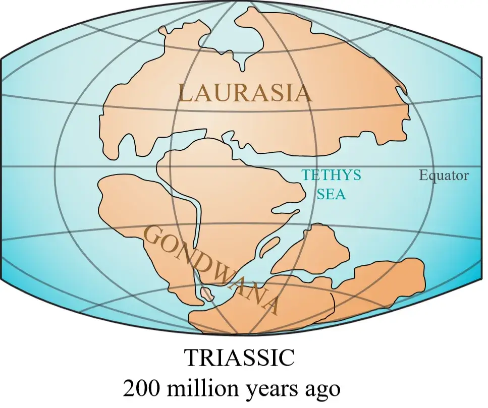
Laurasia and Gondwana approximately 200 million years ago, before the supercontinent’s breakup. Greater Adria would rift from North Africa, Zealandia from eastern Australia–Antarctica, and Argoland from the northwest Australian margin. Source: Wikimedia Commons, CC BY 3.0.
Greater Adria did not vanish. As it subducted beneath what would become the Alps, the Apennines, the Dinarides, the Hellenides, and the Pontides of Turkey, its sedimentary cover was scraped off the descending plate like barnacles. Those scrapings are now the limestone of Tuscany, the marble of the Pindus, the karst of the Balkans. The basement dove deeper, traceable as a slab of high-velocity material in seismic tomography to depths well below 1,000 kilometers. Greater Adria established a template: a continent can disappear and still leave a coherent geological signature, provided it leaves behind an obvious mountain belt.
Zealandia, the Submerged Eighth Continent
The other precedent goes the opposite direction. In early 2017, Nick Mortimer of GNS Science and colleagues published “Zealandia: Earth’s Hidden Continent” in GSA Today (volume 27, issue 3, March/April 2017), making the case that the 4.9-million-square-kilometer expanse of continental crust around New Zealand and New Caledonia satisfies every criterion for continental status, elevation above the surrounding seafloor, a diverse continental rock suite, thicker crust than the surrounding ocean basins, and a defined, coherent area large enough to stand on its own.
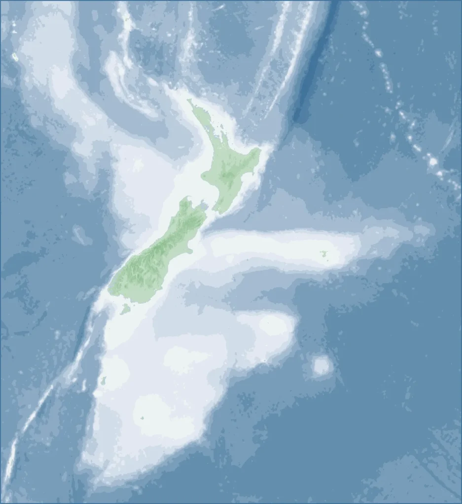
Zealandia, the submerged continent in the southwest Pacific. Roughly 94 percent of its area sits beneath the ocean; only New Zealand and New Caledonia rise above sea level. Map by Alexrk, Wikimedia Commons, CC BY-SA 3.0.
“If we could pull the plug on the world’s oceans,” Mortimer told Science News in 2017, “it would be quite clear that Zealandia stands out.” If it weren’t for the sea, he added, the continent would have been recognised long ago. Roughly 94 percent of it sits beneath the southwest Pacific, with only New Zealand and New Caledonia above sea level. It separated from Gondwana around 100 million years ago, stretched until its crust thinned, and sank below sea level. Like Argoland, Zealandia did not perform a clean continental divorce. Its margins are ragged, its basins are floored by attenuated continental crust and oceanic crust in complicated patterns, and parts of it are still being pulled apart by the Australian-Pacific plate boundary.
Together, Greater Adria and Zealandia bracket the possibilities. A continent can sink with most of its sedimentary lid intact and become a recognizable geological province on the seafloor (Zealandia). Or it can dive into the mantle, donate its skin to a new mountain belt, and survive only as a folded sedimentary record (Greater Adria). Argoland, it turned out, fit neither end of the spectrum cleanly. It had done something stranger, which is part of why finding it took seven years.
Reconstructing Argoland: Seven Years of Fieldwork
The story of how Argoland was reconstructed is, among other things, the story of two geologists’ biographies converging.
From Royal Holloway to the Meratus Mountains
Eldert Advokaat completed his PhD at Royal Holloway, University of London, in 2016, in Robert Hall’s Southeast Asia Research Group. Hall, the group’s founder and longtime director, has spent decades building the regional synthesis that shapes how the international community thinks about Sundaland’s growth. Advokaat’s thesis was titled Neogene Extension and Exhumation in NW Sulawesi, and it was built on dense field campaigns in the rainforest of the North Arm of Sulawesi, paired with U–Pb zircon geochronology, 40Ar/39Ar thermochronology, and apatite (U–Th)/He age data, a battery of geochronometers that let him peel apart phases of Middle Miocene and Late Pliocene–Pleistocene crustal stretching. The argument was that what had been read as collisional crumpling on the North Arm was in fact extension and rollback, linked to slab dynamics in the Celebes Sea.
Mount Kinabalu in Sabah, northern Borneo. The island of Borneo carries the southwest Borneo block, the largest of the six Gondwana-derived fragments Advokaat and van Hinsbergen identify as part of the Argopelago. Photo by David Haslip (Wikimedia user T0lk), Wikimedia Commons, CC BY-SA 4.0.
This sort of work is unglamorous and essential. It is the kind of fieldwork that ends with samples in a Pelican case and a Land Rover bogged in a riverbed. It taught Advokaat the texture of Sulawesi’s basement: which metamorphic complexes were exhumed when, which granitoids were syn-extensional, which ophiolitic slivers were old enough to have been part of something pre-Cretaceous. He spent time on Borneo as well. The 2018 paper he led with Hall, Lloyd White, and others in Tectonics, on the Cenozoic rotation history of Borneo and Sundaland from paleomagnetism and kinematic reconstruction, would later become essential to unwinding the eastern Indonesian arc back to its pre-collision geometry.
The Meratus Mountains of southeast Borneo, with their stretched-out belt of ophiolitic rocks and tectonically jumbled sediments, were one of the touchstone outcrops in that period. So was the Karangsambung mélange of central Java: the Luk Ulo Complex, a chaotic body of eclogite, glaucophane schist, serpentinite, gabbro, basalt, and pelagic chert that records a Cretaceous accretionary collision along the southeastern edge of Sundaland. These are the kinds of rocks that, taken one outcrop at a time, look like noise. Taken across a region, they begin to encode the geometry of arrival.
After Royal Holloway, Advokaat moved to Utrecht as a postdoctoral researcher, then to the University of Birmingham, and back to Utrecht, where he is now Research Coordinator at the Department of Earth Sciences.
The Conceptual Breakthrough at Utrecht
Utrecht University is, by virtue of personnel and methodology, one of the world’s centers of plate-tectonic reconstruction. Douwe J. J. van Hinsbergen, who took his PhD at Utrecht in 2004 and has been on the faculty since 2012, holds the Chair in Global Tectonics and Paleogeography. He is also one of the architects of the Utrecht Paleogeography model, an integrated reconstruction framework that powers tools such as paleolatitude.org and the Atlas of the Underworld, the public database of subducted slabs imaged by seismic tomography that he developed with Douwe van der Meer and Wim Spakman.
That methodological backbone is what made the rest possible. Reconstructing a continent that has already disintegrated requires more than a good map. It requires a systematic way of running deformation backward: restoring the modern accretionary collage to its pre-collision geometry along the Sundaland margin, then sending each piece back across the Tethys to wherever it started on the Australian or Greater Indian shelf. Each restoration has to honor paleomagnetic latitudes, structural cross-sections, ophiolite ages, and the magnetic anomaly pattern in the surviving oceanic crust. Run a step wrong and the entire collage stops fitting.
When Advokaat and van Hinsbergen first attempted to put Argoland back together, they assumed they were looking for a coherent piece. They were not.
“We were literally dealing with islands of information, which is why our research took so long. We spent seven years putting the puzzle together.” — Eldert Advokaat, Utrecht University press release, 23 October 2023.
The breakthrough came when Advokaat recognized that the Gondwana-derived fragments scattered through Southeast Asia had arrived at the Sundaland margin at roughly the same time, in the mid-Cretaceous, between about 110 and 85 million years ago. If the fragments arrived together, they had likely traveled together. They were not pieces of separate continents that had drifted up independently. They were pieces of one thing, a thing that had already been broken when it left Australia.
“The situation in Southeast Asia is very different from places like Africa and South America, where a continent broke neatly into two pieces. Argoland splintered into many different shards. That obstructed our view of the continent’s journey.” — Eldert Advokaat, Utrecht University press release, 23 October 2023.
That recognition is the conceptual move that the 2024 Gondwana Research paper, “Finding Argoland: reconstructing a microcontinental archipelago from the SE Asian accretionary orogen,” 103 pages long in the print version, pages 161 to 263 of volume 128, formalizes. It is open access under CC BY 4.0 and reads, in places, more like a regional geology textbook than a single study, with section after section on the structural restoration of individual blocks: SW Borneo, the Schwaner Mountains, the Meratus suture, the Luk Ulo and Bantimala mélanges of Java and Sulawesi, the West Burma block, the Mount Victoria Land sequence of western Myanmar, the Andaman ophiolite.
The fieldwork for the paper was distributed across years and across countries, Sumatra, the Andaman Islands, Borneo, Sulawesi, and Timor, to test the model and constrain the age of key rock strata. The puzzle, as Advokaat and van Hinsbergen describe it in the paper’s discussion, fits seamlessly between the geological systems of the Himalayas to the west and the Philippines to the east. It fills a 5,000-kilometer gap in the regional plate tectonic record that had been awkwardly open since the Argo Abyssal Plain was first surveyed.
The “Argopelago”: Ribbon Continents and Intervening Oceans
The breakup of Pangaea from 250 million years ago to the present. The dispersal of Gondwana that sent Argoland north across the Tethys is part of this larger choreography: continents and microcontinents drifting away from one another while older oceanic basins between them widened. Source: USGS via Wikimedia Commons, public domain.
Advokaat and van Hinsbergen call the reconstructed entity an Argopelago, a portmanteau of Argoland and archipelago, signaling that what rifted from Australia at 155 Ma was not a continent in the contiguous sense but a collage of ribbon continents (their term) separated by older oceanic basins. The fragments traveled north together as one lithospheric raft because, by the time the Argo spreading center opened, the oceans between them were already there, locked into the same plate. Schematic reconstruction of the Argopelago, a collage of microcontinental ribbons separated by Triassic to Middle Jurassic oceanic basins, as it rifted off northwest Australia at ~155 Ma. From Advokaat & van Hinsbergen 2024, CC BY 4.0.
The “ribbon” framing is doing work. Ribbon continents are long, narrow strips of attenuated continental crust, sometimes only a few hundred kilometers wide, stretched by repeated rifting episodes and bounded by oceanic crust on both sides. The Cordilleran terranes of western North America are sometimes interpreted this way; so is the Lhasa block of Tibet. The Argopelago is a particularly clear example because it can be reconstructed back to a specific donor margin in a specific window of time.
Why Argoland Broke Up Around 215 Million Years Ago
The paper places the start of Argoland’s splintering in the Late Carboniferous to Permian, around 300 million years ago, when extensional events along the northern Gondwana margin first began carving slivers off. The pace picked up sharply in the Late Triassic. By about 215 million years ago, as the Lhasa block was rifting north toward what would become Tibet, the breakup of Argoland accelerated and the continent shattered into thin splinters separated by narrow ocean basins. By the time the Argo seafloor spreading initiated at ~155 Ma, the splinters had already been moving relative to each other for tens of millions of years.
The sequence here is the point. Argoland did not snap cleanly when continental breakup arrived. The margin had been thinning and pulling apart since Pangea was still assembling: 145 million years of cumulative extension before the Argo rift finished the job. The 155 Ma rift only finished what 145 million years of extension had already begun.
Why It Did Not Leave a Mountain Belt
This pre-fracturing also explains the most distinctive feature of Argoland’s afterlife: the lack of a coherent mountain belt marking its accretion. India, when it collided with Asia, raised the Himalayas. Greater Adria, when it dove beneath southern Europe, left the Alps and the Apennines. Argoland, dispersed across thousands of kilometers and stitched into a margin that was simultaneously consuming intervening oceanic basins, never produced an Argo-Himalaya. Its arrival is recorded instead as a long, thin, geographically discontinuous belt of sutures, ophiolites, mélanges, and accreted continental slivers, exactly the architecture of an accretionary orogen.
That accretionary orogen, Sundaland and its eastern extension into Sulawesi, the Banda Arc, and Myanmar, is the most kinematically scrambled region on Earth’s surface today. Robert Hall’s syntheses (2012 in Tectonophysics, and 2017 in the Annual Review of Earth and Planetary Sciences) describe it as a region that has been growing by terrane accretion since the Early Mesozoic, with overlapping arc systems and rolling-back subduction zones rearranging the geometry on time scales of tens of millions of years. The Argo Abyssal Plain demanded a 5,000-kilometer continental input. Sundaland delivered the locations where one could be hidden.
“If continents can dive into the mantle and disappear entirely, without leaving a geological trace at the earth’s surface, then we wouldn’t have much of an idea of what the earth could have looked in the geological past.” — Douwe van Hinsbergen, Utrecht University press release, 23 October 2023.
The Argoland reconstruction matters in part because it pushes back against the implicit assumption that vanished continents must leave clear, mountain-belt-scale traces. The Argopelago shows that a continent can disperse so thoroughly through an accretionary collage that no single mountain belt records its passage. The signal is there, but it has to be reassembled from a hundred outcrops across half a dozen countries.
The Six Fragments of Argoland
The 2024 paper identifies six Gondwana-derived blocks and mega-units that, taken together, may represent the fragments of Argoland: SW Borneo, Greater Paternoster, East Java, South Sulawesi, West Burma, and Mount Victoria Land. They are separated by sutures that contain relics of Late Triassic to Middle Jurassic oceanic basins, older than the 155 Ma Argo rift itself, exactly what the Argopelago model predicts.
Southwest Borneo
The southwest Borneo block is the largest of the fragments. It forms the basement of much of Kalimantan, including the Schwaner Mountains of the southern interior, which expose Cretaceous granitoids intruded into older metamorphic rock. To its east, the Meratus Mountains of southeast Borneo expose an ophiolitic and mélange-dominated suture, the relic of a Late Triassic to Middle Jurassic ocean basin that once separated SW Borneo from the next Argoland fragment. The Meratus suture is one of the seams of the Argopelago, sewn shut when SW Borneo welded to the rest of the collage during the mid-Cretaceous.
Greater Paternoster, East Java, and South Sulawesi
Forested terrain on Sulawesi, Indonesia. The South Arm of the island exposes the Bantimala Complex: a Cretaceous high-pressure suite with blueschist and eclogite-bearing rocks that records the closure of one of the intervening Argopelago basins. Source: Wikimedia Commons, CC BY-SA 3.0.
Greater Paternoster is the broad continental basement underlying the Paternoster Platform, the East Java Sea, and the Makassar Strait region: an area sometimes obscured in popular accounts because most of it is offshore, beneath shallow Cenozoic basins. East Java’s basement and the South Sulawesi basement, both with affinities to the same Gondwanan provenance, are reconstructed in the paper as separate but related ribbon fragments. South Sulawesi in particular is geologically important because of the Bantimala Complex: a Cretaceous high-pressure metamorphic suite, including blueschist and eclogite-bearing rocks, that records subduction of an oceanic basin on the leading edge of one of the Argoland ribbons.
The Karangsambung mélange of central Java, the Luk Ulo Complex, is another part of this story, exposing the mixing zone where one Argoland ribbon was shoved against the next as the intervening basins closed. The paper draws on the published radiolarian biostratigraphy of these mélanges, alongside detrital zircon ages and structural restorations, to bracket when each suture was active.
West Burma and Mount Victoria Land
The two westernmost Argoland fragments now lie in Myanmar. The West Burma block forms much of the basement of western Myanmar, sutured along its eastern edge against the Sibumasu block (which is itself Gondwana-derived but on an older trajectory, having rifted in the Early Permian). The Mount Victoria Land sequence, named for the highest peak of the Chin Hills of western Myanmar, exposes a Triassic flysch and overlying ophiolite that correlate, in age and lithology, with the Yarlung-Zangbo suture ophiolite of southern Tibet. Earlier workers, including Mitchell and colleagues in the 1980s and 1990s, had argued that Mount Victoria Land was a separate Gondwana-derived block that had collided with Burma in the Early Cretaceous following subduction of an intervening ocean. The Argoland reconstruction places this scenario within a coherent regional framework: Mount Victoria Land was the westernmost ribbon of the Argopelago, the first of the fragments to dock at the Sundaland margin as the collage swept north.
The paper also discusses material on the Andaman Islands, a transitional region where Argoland-related ophiolites are exposed along an island chain that today sits between West Burma to the north and Sumatra to the south. Advokaat’s fieldwork in the Andamans was one of the late additions to the dataset.
What ties the six fragments together is the docking window. Restored back through the upper plate above the modern Sunda trench, every Argoland ribbon arrived at the Sundaland margin between roughly 110 and 85 million years ago, in the mid-Cretaceous. They left Australia together, drifted together, and docked together, even though by docking time the intervening oceanic basins between them had already been narrowing for 100 million years.
What Argoland Tells Us About Lost Worlds We Still Cannot See
The immediate scientific result of the Argoland reconstruction is filling a hole in the global plate tectonic record. The deeper one is what the project demonstrates about method. If a continent the size of the contiguous United States could disappear into the geology of Southeast Asia and remain elusive for fifty years, then other continents may still be hiding under other orogens.
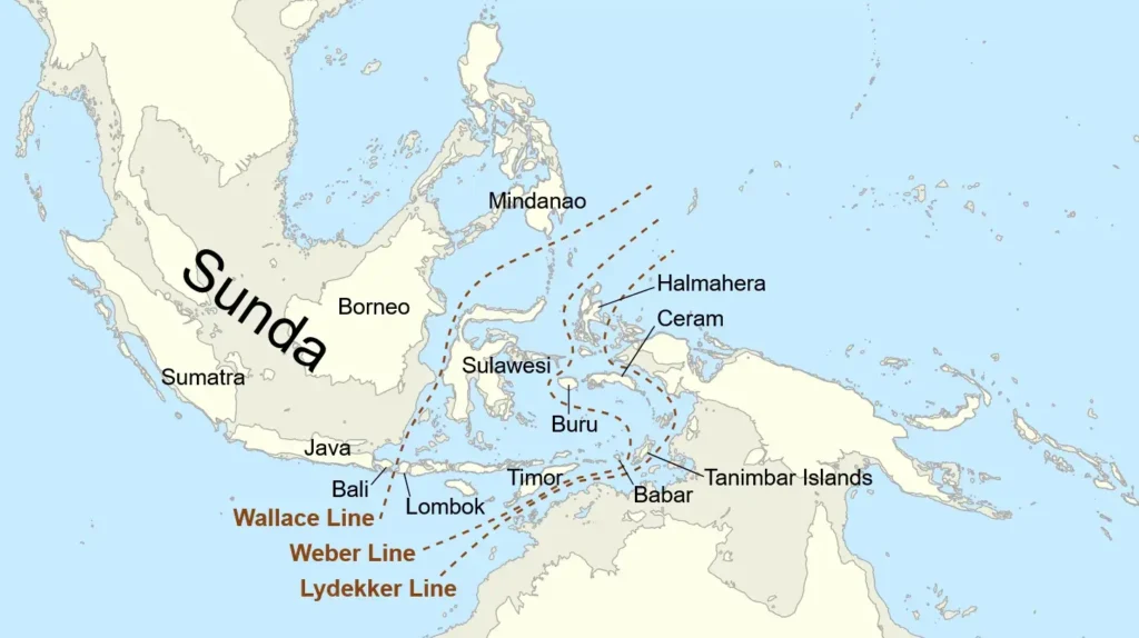
The Wallace Line and Biodiversity
The Wallace Line, Weber Line, and Lydekker Line bracket Wallacea, the biogeographic transition between Asian and Australasian faunas. Argoland fragments underlie basement on both sides of this divide. Source: Wikimedia Commons, CC BY-SA 4.0.
Alfred Russel Wallace first described the discontinuity in 1859, in a paper communicated by Darwin and read at the Linnean Society on 3 November 1859, published the following year as “On the Zoological Geography of the Malay Archipelago,” Journal of the Proceedings of the Linnean Society: Zoology 4 (1860): 172–84. He noticed that the animals on either side of a narrow strait in eastern Indonesia refused to mix. Bali, Java, and Borneo carry an Asian fauna, tigers, elephants, primates. Lombok, Sulawesi, and the islands eastward carry an Australasian fauna, cockatoos, marsupials, megapodes. The Lombok and Makassar straits between them are narrow but old, and old enough to have acted as biogeographic filters.
The Argoland paper does not claim to solve the Wallace Line. But the paleogeographic framework it provides bears directly on Wallacean biogeography. If Argoland fragments, SW Borneo, Greater Paternoster, East Java, South Sulawesi, were drifting northward through the Tethys for tens of millions of years before docking at Sundaland in the mid-Cretaceous, then the deep history of the islands on either side of the Wallace Line is asymmetric in a way that ordinary continental geography does not capture. Some Wallacean islands sit on basement that traveled with Argoland from Australia; others sit on basement that has always been Asian. That deep asymmetry, layered beneath the Cenozoic arc volcanism and the Quaternary sea level history that biogeographers usually emphasize, could plausibly seed differences in the platform that later biotic dispersals had to negotiate.
The 2024 paper frames this lightly. Reconstructions of this kind are “vital for our understanding of processes like the evolution of biodiversity and climate,” van Hinsbergen has said. The bar for claiming that Argoland’s history actively shaped the Wallace Line is much higher, and the paper does not vault it.
Critical Minerals in Accretionary Belts
Accretionary orogens are mineral provinces. The ophiolitic sutures between Argoland ribbons host chromite, nickel, and platinum-group elements; the volcanic arcs welded across the suture zones carry porphyry copper and epithermal gold; the granitoids of the Schwaner Mountains and the West Burma block include tin and tungsten in their accessory mineralogy. Indonesia is now the world’s single largest nickel producer, commanding 61.3% of global mine production in 2024, with the Philippines a distant second at 9.2%, according to Natural Resources Canada data compiled by Statista (January 2026). Malaysia and Myanmar have long histories in tin. Sundaland’s economic geology is the inverted shadow of its accretionary history. Knowing which crustal block came from where, when it docked, and what it carried into the collision is not abstract paleogeography, it is a map of the leads worth following.
How Many Continents Are We Still Missing?
Argoland joins Greater Adria and Zealandia on a short list of continental-scale paleogeographic entities reconstructed in the last decade. Mauritia, a postulated microcontinent established by Lewis D. Ashwal, Michael Wiedenbeck, and Trond H. Torsvik in “Archaean zircons in Miocene oceanic hotspot rocks establish ancient continental crust beneath Mauritius,” Nature Communications, 31 January 2017 (DOI 10.1038/ncomms14086), finding zircons as old as 3 billion years inside 5.7 Ma trachytic rocks on Mauritius, may be another. The Tethys Himalaya is, in some readings, the metamorphosed and folded remnant of a similar drifting margin. The implication is methodological as much as it is regional: the techniques that recovered Argoland, paleomagnetic restoration, kinematic backward modeling, careful integration of structural cross-sections and zircon geochronology, paired with the Atlas of the Underworld‘s tomographic catalog of subducted slabs, can be turned on other deformed regions, with reasonable expectation of finding more.
The deeper point is van Hinsbergen’s: a continent can dive into the mantle and effectively disappear at the surface. The question is whether the geological community has the methods to recognize the partial signals it leaves behind. After Argoland, the answer is closer to yes than it was a decade ago.
Back at the void off Western Australia, the Argo Abyssal Plain remains 5,730 meters of saltwater above nearly a kilometer of pelagic sediment above the oldest sliver of Indian Ocean floor anyone has yet drilled. What fills it now is Tethyan oceanic crust that opened in the wake of Argoland’s departure, capped by the slow rain of pelagic carbonate that has accumulated since the Jurassic: a record of the empty ocean that replaced a continent, written in the carapaces of plankton on a basement of pillow basalt. The continent itself is 4,000 kilometers north, distributed across the green jungles of Borneo and Java and Sulawesi and the hill country of Myanmar, sutured into a margin that did not exist when Argoland left.